Document 11277514
advertisement
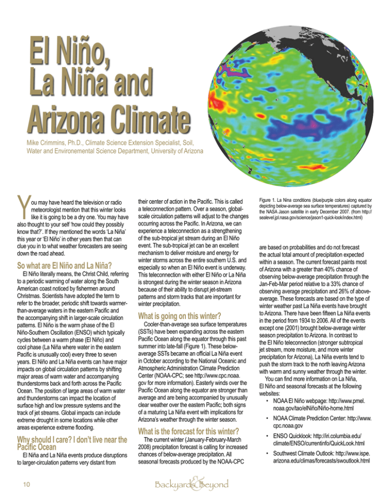
El Niño, La Niña and Arizona Climate Mike Crimmins, Ph.D., Climate Science Extension Specialist, Soil, Water and Environemental Science Department, University of Arizona Y ou may have heard the television or radio meteorologist mention that this winter looks like it is going to be a dry one. You may have also thought to your self ‘how could they possibly know that?’. If they mentioned the words ‘La Niña’ this year or ‘El Niño’ in other years then that can clue you in to what weather forecasters are seeing down the road ahead. So what are El Niño and La Niña? El Niño literally means, the Christ Child, referring to a periodic warming of water along the South American coast noticed by fishermen around Christmas. Scientists have adopted the term to refer to the broader, periodic shift towards warmerthan-average waters in the eastern Pacific and the accompanying shift in larger-scale circulation patterns. El Niño is the warm phase of the El Niño-Southern Oscillation (ENSO) which typically cycles between a warm phase (El Niño) and cool phase (La Niña where water in the eastern Pacific is unusually cool) every three to seven years. El Niño and La Niña events can have major impacts on global circulation patterns by shifting major areas of warm water and accompanying thunderstorms back and forth across the Pacific Ocean. The position of large areas of warm water and thunderstorms can impact the location of surface high and low pressure systems and the track of jet streams. Global impacts can include extreme drought in some locations while other areas experience extreme flooding. Why should I care? I don’t live near the Pacific Ocean El Niña and La Niña events produce disruptions to larger-circulation patterns very distant from 10 their center of action in the Pacific. This is called a teleconnection pattern. Over a season, globalscale circulation patterns will adjust to the changes occurring across the Pacific. In Arizona, we can experience a teleconnection as a strengthening of the sub-tropical jet stream during an El Niño event. The sub-tropical jet can be an excellent mechanism to deliver moisture and energy for winter storms across the entire southern U.S. and especially so when an El Niño event is underway. This teleconnection with either El Niño or La Niña is strongest during the winter season in Arizona because of their ability to disrupt jet-stream patterns and storm tracks that are important for winter precipitation. What is going on this winter? Cooler-than-average sea surface temperatures (SSTs) have been expanding across the eastern Pacific Ocean along the equator through this past summer into late-fall (Figure 1). These belowaverage SSTs became an official La Niña event in October according to the National Oceanic and Atmospheric Administration Climate Prediction Center (NOAA-CPC; see http://www.cpc.noaa. gov for more information). Easterly winds over the Pacific Ocean along the equator are stronger than average and are being accompanied by unusually clear weather over the eastern Pacific; both signs of a maturing La Niña event with implications for Arizona’s weather through the winter season. What is the forecast for this winter? The current winter (January-February-March 2008) precipitation forecast is calling for increased chances of below-average precipitation. All seasonal forecasts produced by the NOAA-CPC & Backyards Beyond Figure 1. La Nina conditions (blue/purple colors along equator depicting below-average sea surface temperatures) captured by the NASA Jason satellite in early December 2007. (from http:// sealevel.jpl.nasa.gov/science/jason1-quick-look/index.html) are based on probabilities and do not forecast the actual total amount of precipitation expected within a season. The current forecast paints most of Arizona with a greater than 40% chance of observing below-average precipitation through the Jan-Feb-Mar period relative to a 33% chance of observing average precipitation and 26% of aboveaverage. These forecasts are based on the type of winter weather past La Niña events have brought to Arizona. There have been fifteen La Niña events in the period from 1934 to 2006. All of the events except one (2001) brought below-average winter season precipitation to Arizona. In contrast to the El Niño teleconnection (stronger subtropical jet stream, more moisture, and more winter precipitation for Arizona), La Niña events tend to push the storm track to the north leaving Arizona with warm and sunny weather through the winter. You can find more information on La Niña, El Niño and seasonal forecasts at the following websites: • NOAA El Niño webpage: http://www.pmel. noaa.gov/tao/elNiño/Niño-home.html • NOAA Climate Prediction Center: http://www. cpc.noaa.gov • ENSO Quicklook: http://iri.columbia.edu/ climate/ENSO/currentinfo/QuickLook.html • Southwest Climate Outlook: http://www.ispe. arizona.edu/climas/forecasts/swoutlook.html
