Aeromagnetic and airborne radioactivity maps
advertisement
Aeromagnetic
andairborne
radioactivity
mapsandprofilesin NewMexico
published
oropen-filed
bythe
U.S.Geological
Survey
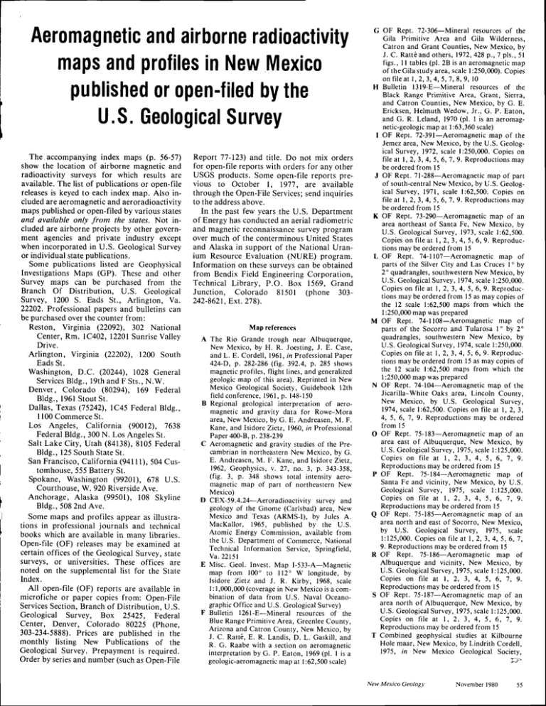
The accompanying index maps (p. 56-57)
show the location of airborne magnetic and
radioactivity surveys for which results are
available. The list of publications or open-file
releasesis keyed to each index map. Also included are aeromagnetic and aeroradioactivity
maps published or open-filed by various states
and availqble only from the states. Not included are airborne projects by other government agencies and private industry except
when incorporated in U.S, Geological Survey
or individual statepublications.
Some publications listed are Geophysical
Investigations Maps (GP). These and other
Survey maps can be purchased from the
Branch Of Distribution, U.S. Geological
Survey, 1200 S. Eads St., Arlington, Va.
22202. Professional papers and bulletins can
be purchased over the counter from:
Reston, Virginia (22092), 302 National
Center, Rm. 1C402, 12201SunriseValley
Drive.
Arlington, Virginia (22202), 1200 South
Eads St.
Washington, D.C. (20244), 1028 General
ServicesBldg., 19th and F Sts., N.W.
Denver, Colorado (80294), 169 Federal
B l d g . , l 9 6 l S t o u tS r .
Dallas, Texas (75242), lC45 Federal Bldg.,
I100 CommerceSt.
Los Angeles, California (90012), 7638
FederalBldg., 300 N. Los AngelesSt.
Salt Lake City, Utah (84138),8105 Federal
Bldg., 125South StateSt.
San Francisco,California (941l1), 504 Customhouse,555 Battery St.
Spokane, Washington (99201), 678 U.S.
Courthouse,W. 920 RiversideAve.
Anchorage, Alaska (99501), 108 Skyline
Bldg., 508 2nd Ave.
Some maps and profiles appear as illustrations in professional journals and technical
books which are available in many libraries.
Open-file (OF) releasesmay be examined at
certain offices of the Geological Survey, state
surveys, or universities. These offices are
noted on the supplemental list for the State
Index.
All open-file (OF) reports are available in
microfiche or paper copies from: Open-File
ServicesSection,Branch of Distribution, U.S.
Geological Survey, Box 25425, Federal
Center, Denver, Colorado 80225 (Phone,
303-234-5888).Prices are published in the
monthly listing New Publications of the
Geological Survey. Prepayment is required.
Order by seriesand number (such as Open-File
Report 77-123) and title. Do not mix orders
for open-file reports with orders for any other
USCS products. Some open-file reports prev i o u s t o O c t o b e r I , 1 9 ' 7 7, a r e a v a i l a b l e
through the Open-File Services; send inquiries
to the address above.
In the past few years the U.S. Department
of Energy has conducted an aerial radiometric
and magnetic reconnaissance survey program
over much of the conterminous United States
and Alaska in support of the National Uranium Resource Evaluation (NURE) program.
Information
on these surveys can be obtained
from Bendix Field Engineering Corporation,
Technical Library, P.O. Box 1569, Grand
Junction,
Colorado
81501 (phone
303242-8621. Ext.278).
Map references
A The Rio Grande trough near Albuquerque,
N e w M e x i c o , b y H . R . J o e s t i n g ,J . E . C a s e ,
and L. E. Cordell, 1961,in Professional Paper
424-D, p. 282-286 (fig. 392.4, p. 285 shows
magnetic profiles, flight lines, and generalized
geologic map of this area). Reprinted in New
Mexico Geological Society, Guidebook l2th
f i e l d c o n f e r e n c e ,1 9 6 1 ,p . 1 4 8 - 1 5 0
B Regional geological interpretation of aeromagnetic and gravity data for Rowe-Mora
a r e a , N e w M e x i c o , b y G . E . A n d r e a s e n ,M . F .
Kane, and lsidore Zielz, 1960, in Professional
Paper400-8, p.238-239
C Aeromagnetic and gravity studies of the Precambrian in northeastern New Mexico, by G.
E. Andreasen, M. F. Kane, and Isidore Zietz,
1 9 6 2 , G e o p h y s i c s ,v . 2 7 , n o . 3 , p . 3 4 3 - 3 5 8 ,
(fig.3, p.348 shows total intensityaeromagnetic map of part of northeastern New
Mexico)
D CEX-59.4.24-Aeroradioactivity
survey and
geology of the Gnome (Carlsbad) area, New
Mexico and Texas (ARMS-I), by Jules A.
MacKallor, 1965, published by the U.S.
Atomic Energy Commission, available from
t h e U . S . D e p a r t m e n to f C o m m e r c e ,N a t i o n a l
Technical Information Service, Springfield,
Ya.22151
E Misc. Geol. Invest. Map I-533-A-Magnetic
map from 100" ro l12" W longitude, by
Isidore Zietz and J. R. Kirby, 1968, scale
1: 1,000,000(coveragein New Mexico is a combination of data from U.S. Naval Oceanographic Office and U.S. Geological Survey)
F Bulletin l26l-E-Mineral
resources of t}re
B l u e R a n g e P r i m i t i v e A r e a , G r e e n l e eC o u n t y ,
Arizona and Catron County, New Mexico, by
J. C. Ratt6, E. R. Landis, D. L. Gaskill. and
R . C . R a a b e w i t h a s e c r i o no n a e r o m a g n e l i c
i n r e r p r e t a t i o nb y G . P . E a t o n , 1 9 6 9( p l . I i s a
geologic-aeromagneticmap at l:62,500 scale)
G OF Rept. 72-306-Mineral resources of the
Gila Primitive Area and Gila Wilderness,
C a t r o n a n d G r a n t C o u n t i e s ,N e w M e x i c o , b y
J . C . R a t t 6 a n do t h e r s ,1 9 7 2 ,4 2 8 p . , 7 p l s . , 5 l
f i g s . , I I t a b l e s( p l . 2 B i s a n a e r o m a g n e t i cm a p
o f t h e G i l a s t u d y a r e a ,s c a l el : 2 5 0 , 0 0 0 ) .C o p i e s
o n f i l ea t 1 , 2 , 3 , 4 , 5 , 7 , 8 , 9 , l 0
resources of the
H Bulletin l3l9-E-Mineral
Black Range Primitive Area, Grant, Sierra,
and Catron Counties, New Mexico, by G. E.
E r i c k s e n ,H e l m u t h W e d o w , J r . , G . P . E a t o n ,
and G. R. Leland, 1970 (pl. I is an aeromagnetic-geologicmap at 1:63,360scale)
I OF Rept. 72-391-Aeromagnetic map of the
Jemez area, New Mexico, by the U.S. Geologi c a l S u r v e y , 1 9 7 2 ,s c a l e l : 2 5 0 , 0 0 0 . C o p i e s o n
f i l e a t l , 2 , 3 , 4 , 5 , 6 , 7 , 9 . R e p r o d u c t i o n sm a y
be ordered from l5
J OF Rept. 7l-288-Aeromagnetic map of parr
o f s o u t h - c e n t r aN
l ew Mexico, by U.S. Geological Survey, 1971, scale l:62,500. Copies on
f i l e a t l , 2 , 3 , 4 , 5 , 6 , 7 , 9 . R e p r o d u c t i o nmsa y
be ordered from l5
K OF Rept. 73-29O-Aeromagnetic map of an
area northeast of Santa Fe, New Mexico, by
U . S . G e o l o g i c a l S u r v e y , 1 9 7 3 ,s c a l e l : 6 2 , 5 0 0 .
C o p i e so n f i t e a t 1 , 2 , 1 , 4 , 5 , 6 , 9 . R e p r o d u c tions may be ordered from l5
L OF Rept. 74-1lO7-Aeromagnetic map of
parts of the Silver City and Las Cruces I " by
2" quadrangles, southwesternNew Mexico, by
U . S . G e o l o g i c a lS u r v e y , 1 9 7 4 ,s c a l e1 : 2 5 0 , 0 0 0 .
C o p i e so n f i l e a t l , 2 , 3 , 4 , 5 , 6 , 9 . R e p r o d u c tions may be ordered from 15 as may copies of
the 12 scale 1:62,500 maps from which the
l:250,000 map was prepared
M OF Rept. 74-llO8-Aeromagnetic map of
parts of the Socorro and Tularosa 1" by 2"
quadrangles, southwestern New Mexico, by
U . S . G e o l o g i c a lS u r v e y , 1 9 7 4 ,s c a l el : 2 5 0 , 0 0 0 .
C o p i e so n f i l e a t l , 2 , 3 , 4 , 5 , 6 , 9 . R e p r o d u c tions may be ordered from 15 as may copies of
the 12 scale l:62,500 maps from which the
l:250,000 map was prepared
N OF Rept. 74-I04-Aeromagnetic r'ap of the
Jicarilla-White Oaks area, Lincoln County,
New Mexico, by U.S. Geological Survey,
19'74,scale l:62,500. Copies on file at l, 2, 3,
4 , 5 , 6 , 7 , 9 . R e p r o d u c t i o n sm a y b e o r d e r e d
from 15
O OF Rept. 75-183-Aeromagnetic map of an
area east of Albuquerque, New Mexico, by
U . S . G e o l o g i c a lS u r v e y , 1 9 7 5 ,s c a l el : 1 2 5 , 0 0 0 .
C o p i e so n f i l e a t 1 , 2 , 3 , 4 , 5 , 6 , 7 , 9 .
Reproductions may be ordered from l5
P OF Rept. 75-I84-Aeromagnetic
map of
Santa Fe and vicinity, New Mexico, by U.S.
Ceological Survey, 1975, scale l:125,000.
Copies on file at I, 2, 3, 4, 5, 6, 7, 9.
Reproductions may be ordered from l5
Q OF Rept. 75-I85-Aeromagnetic map of an
area north and east of Socorro, New Mexico,
by U.S. Geological Survey,1975, scale
l : 1 2 5 , 0 0 0C. o p i e so n f i l e a t l , 2 , 3 , 4 , 5 , 6 , 7 ,
9. Reproductions may be ordered from l5
R OF Rept. 75-186-Aeromagnetic map of
Albuquerque and vicinity, New Mexico, by
U . S . G e o l o g i c a lS u r v e y , 1 9 7 5 ,s c a l el : 1 2 5 , 0 0 0 .
C o p i e so n f i l e a t l , 2 , 3 , 4 , 5 , 6 , 7 , 9 .
Reproductions may be ordered from I 5
S OF Rept. 75-I87-Aeromagnetic map of an
area north of Albuquerque, New Mexico, by
U . S . G e o l o g i c a lS u r v e y , 1 9 7 5 ,s c a l el : 1 2 5 , 0 0 0 .
Copies on file at 1, 2, 3, 4, 5, 6, 7, 9.
Reproductions may be ordered from I 5
T Combined geophysical studies at Kilbourne
Hole maar, New Mexico, by Lindrith Cordell,
1975, in New Mexico Geological Society,
New Mexico Geology
November1980
and airbornerad
USGSaeromagnetic
-.
oRatoi,_
I
\i\
(i
'
"'
I
\R
|
o
\-
i
t.
^
,
--_--] - (
\.,\ l. 1
ir-- -l
I
I
MCKIN
Gaiiup
-
ir
I
LEY
-;
' i-1:v
,
." -in"!
:
it
rlT
VA
TOR
,--
a -:--l
"
i
t-,
I
J
"3,*'*
"t
"bo.ru.rf
"+;_r
t
I'
,'
-
lo
_-_i--^
./ \
n---{
---1'
--l
-
Lwlneton e
|
-1
..^
, 8 t - .I
_--.;
I
L
I
I
i
I
i
I
NOTE-Lettered
November 1980
New Mexico Geology
and numbered areasrefer to referenceslisted in the text (p.
rctivity mapsand profilesof New Mexico
10a.
-.'
\
'
\i\
, 'j-
,os
N1 l-.a
i
,
f
-
\r-
r o
A
J
),
Taos
l
I
N I O r-{_ ^
ru
)
\ - ( \)
'f---i----
rE
-
s.2
r-B\
\-R
\--
-l
v'
-tt
s rie,,a
oRatoni.'
\,'
t\
I
^,
t
- l - ' - ' lt
-
I
.i.
/
Gallup
/
,
-
-
i) t.
i
)
.-zj\1 t. '
/
:
ir ---l
E t .-i*.-
L
MCKIN
I
I
I
't"
.l
z'-
\
/
Luries
Estano.o
I
ITOR
I
)
_-t---------
.l
j--
t\
l2
\
-----
l\
--L a-- -
--------iz
I
a****
o Ca.nzob
t
'n
UNA
\;
.ll
I -"c
i&.s*bil9
1i i;'a"'
al-----
.]'"
I
$]
oo
1
E . . R g _ . ._
\
1
,.
'F--f
r
ANA
I
i
^;-------t--;-
rit
i\*l
t -no{3'
---l
/l-
"'J i-:---i
I
'lr'
t\
\l
.l
I
t_
gOLN
LIN
,T---r1 ne)
-t
"3,,",*J
"l
I,r
I
l/
./+'
LJl.,1
.-*o".rl I
il
Di
i
I
i nboseverf
,-l
\
/l/
-l
"""'tt"
"
-----.
i(
t.--
-
t -'I
rl
L__r___
/
'^
-"T
I
-'l
-,r;
I
, -- -\ r\ , t
Las Cruccs I
I
I
"i
\
0
-
' nl
r'-
iut
| . --'
'l
l /
it'
-,,
,'i '
58); the index maps and colors are used only as aids in locating separatesheets.
New Mexico Geology
November1980
U
Y
W
X
Y
Z
AA
BB
CC
DD
EE
FF
G u i d e b o o k 2 6 t h f i e l d c o n f e r e n c e ,p . 2 6 9 - 2 7 1
(fig. 3 is a total intensity aeromagnetic map)
OF Rept. 76-503-Aeromagnetic map of an
area north of Abiquiu, New Mexico, by U.S.
Geological Survey, 1976, scale l:62,500.
Copies on file at l, 2, 3, 4, 5, 6, 7, 9.
Reproductions may be ordered from l5
OF Rept. 76-504-Aeromagnetic map of
Wheeler Peak and vicinity, New Mexico, by
U . S . G e o l o g i c a lS u r v e y , 1 9 7 6 ,s c a l e l : 6 2 , 5 0 0 .
C o p i e so n f i l e a t I , 2 , 3 , 4 , 5 , 6 , 7 , 9 .
Reproductions may be ordered from I 5
O F R e p t . 7 5 - 3 8 5 - M i n e r a l r e s o u r c e so f t h e
White Mountain Wilderness and adjacent
areas, Lincoln County, New Mexico, by K.
S e g e r s t r o ma n d o t h e r s , 1 9 7 5 , a e r o m a g n e t i c
m a p s c a l el : 6 2 , 5 0 0 . C o p i e so n f l l e a l 1 , 2 , 3 , 4 ,
5 , 6 , 7 . R e p r o d u c t i o n sm a y b e o r d e r e d f r o m
l5
OF Rept. 76-440-lnterpretation of magnetic
s u r v e y si n i n t e r m o n t a n ev a l l e y so f N e v a d aa n d
southern New Mexico, by G. D. Bath, 1976(p.
l 5 c o n t a i n s a n a e r o m a g n e t i cm a p , d a t a f r o m
U . S . N a v a l O c e a n o g r a p h i cO f f i c e ) . C o p i e s o n
f i f ea t l , 2 , 3 , 4 , 5 , 6 , 1 , 1 l
OF Rept. 76-686-Aeromagnetic map of
Carson and vicinity, New Mexico, by U.S.
Geological Survey, 1976, scale 1:62,500
Copies on file at I, 2, 3, 4, 5, 6, 7, 9.
Reproductions may be ordered from l5
OF Rept. 76-806-Residual magnetic intensity
map of centralNew Mexico, by U.S. Geologi c a l S u r v e y , 1 9 7 6 ,s c a l e l : 2 5 0 , 0 0 0 . C o p i e s o n
f i l e a t l , 2 , 3 , 4 , 5 , 6 , 7 , 9 . R e p r o d u c t i o nm
s ay
be ordered from l5
OF Rept. 77-2s8-Aeromagnetic maps with
geologic interpretations for the Tularosa
Valley, south-central New Mexico, by G. D.
B a t h , 1 9 7 7 ,s c a l el : 6 2 , 5 0 0 a n d l : 4 0 0 , 0 0 0( d a t a
from U.S. Naval Oceanographic Office).
C o p i e so n f i l e a t l , 2 , 3 , 4 , 5 , 6 , 7 . R e p r o d u c tions may be ordered from I 5
OF Rept. 79-l452-Aeromagnetic map of the
n o r t h a n d w e s t p a r t s o f t h e S i l v e rC i t y l ' b y 2 "
q u a d r a n g l e ,N e w M e x i c o a n d A r i z o n a , 1 9 7 9 ,
s c a l el : 6 2 , 5 0 OC
. o p i e so n f i l e a t l , 2 , 3 , 4 , 5 , 6 ,
7 , 1 2 , 1 3 , 1 4 . R e p r o d u c t i o n sm a y b e o r d e r e d
from l 5
OF Rept. 79-1644-Aeromagnetic map of the
Malpais area, New Mexico, 1979, scale
l : 2 5 0 , 0 0 0 C o p i e so n f i l e a t l , 2 , 3 . R e p r o d u c tions may be ordered from l5
OF Rept. 66-137-Aeromagnetic map of San
Simon Valley and vicinity, Cochise, Graham
a n d G r e e n l e eC o u n t i e s ,A r i z o n a , a n d H i d a l g o
C o u n t y , N e w M e x i c o , 1 9 6 6 ,s c a l e l : 1 2 5 , 0 0 0 .
Copies on file at 4, 5, 8, 13. Reproductions
may be ordered from I 5
OF Rept. 80-614-Aeromagnetic map of
n o r t h e a s tA r i z o n a a n d n o r t h w e s tN e w M e x i c o ,
1 9 8 0 ,s c a l el : 2 5 0 , 0 0 0 ,4 s h e e t s .R e p r o d u c t i o n s
may be ordered from I 5
OF Rept. 80-671-Aeromagnetic map of the
Pecos area, New Mexico, scale l:62,500, 4
sheets(in process)
lE GP-18-Parts of San Miguel and Guadalupe
C o u n t i e s( R . l 6 E - R . 2 l E . a n d T . 6 N . - T . l 0
N., and part of Anton Chico Grant), by W J.
D e m p s e ya n d M E . H i l l , 1 9 5 0
Aeromagnetic maps of the following quadrangles
areat I mile = I inch scale:
355 CP-355-Parts of southern Colfax, northern
M o r a , a n d w e s t e r nH a r d i n g C o u n t i e s , b y W .
J . D e m p s e y ,E r n e s tP a g e ,a n d o t h e r s , 1 9 6 3
356 CP-356-Parts of southern Mora, northern
S a n M i g u e l , a n d w e s t e r nH a r d i n g C o u n t i e s ,b y
W J . D e m p s e y ,C a r l L o n g , a n d o t h e r s , 1 9 6 3
357 GP-3s7-Central part of San Miguel County,
by W. J Dempsey, Frank Petrafeso, and
others,1963
424 CP-424-Aeromagnetic and geologic map of
part of the Silver City mining region, Grant
C o u n t y , N e w M e x i c o , b y W . R . J o n e s ,J . E
C a s e ,a n d W . P P r a t t , 1 9 7 4 ,s c a l el : 6 3 , 3 6 0
4 6 2 G P - 4 6 2 - N a t u r a l g a m m a a e r o r a d i o a c t i v i t yo f
t h e G n o m e ( C a r l s b a d )a r e a , N e w M e x i c o a n d
Texas, by J. A MacKallor, 1964, scale
l:250,000
83E GP-838-Aeromagnetic map of the MorenciM o n t i c e l l o a r e a , s o u t h e a s t e r nA r i z o n a a n d
s o u t h w e s t e r nN e w M e x i c o , b y U . S . G e o l o g i c a l
S u r v e y , 1 9 7 2 ,s c a l el : 2 5 0 , 0 0 0
861 GP-861-Aeromagnetic map of the Carlsbad
a r e a , N e w M e x i c o a n d T e x a s ,b y U . S . G e o l o g i c a l S u r v e y , 1 9 7 3 ,s c a l el : 2 5 0 , 0 0 0
Map inspection locations
U S . G e o l o g i c a lS u r v e y L i b r a r y , R m . 4 - A - 1 0 0 ,
12201 Sunrise Valley Dr., Reston, Virginia
22092
2 U.S. Geological Survey Library, 345 Middtefield Rd.. Menlo Park, California94025
3. U S. Geological Survey Library, Stevinson
B l d g . # 3 , D e n v e r W e s t O f f i c e P a r k , 1 5 2 6C o l e
Blvd.. Golden.Colorado 80401
4 . F e d e r a lO f f i c e B u i l d i n g , R m . 8 1 0 5 , S a l t L a k e
City, Utah 84138
5. FederalBuilding, Rm. 169, l96l Stout St.,
D e n v e r ,C o l o r a d o 8 0 2 9 4
6 R m . l - C - 4 5 , I 1 0 0 C o m m e r c eS t . , D a l l a s , T e x a s
l.
1<aA1
7 . U , S . C e o l o g i c a lS u r v e y , 5 0 5 M a r q u e t t e N W . ,
A l b u q u e r q u e ,N e w M e x i c o 8 7 1 2 5
8 Arizona Bureau of Mines, University of
A r i z o n a . T u c s o n .A r i z o n a 8 5 7 2 1
9. New Mexico Bureau of Mines and Mineral
Resources.Socorro, New Mexico 87801
l 0 U . S . G e o l o g i c a lS u r v e y ,W a t e r R e s o u r c e sD i v i s i o n , S i l v e rC i t y , N e w M e x i c o 8 8 6 0 1
II
N e v a d aB u r e a u M i n e s a n d G e o l o g y , U n i v e r s i t y
o f N e v a d a . R e n o . N e v a d a8 9 5 5 7
12. Custom House, Rm. 504, 555 Battery St , San
F r a n c i s c o ,C a l i f o r n i a 9 4 1I I
IJ
(R.2l E.-R.26E.andr. 3 N.-r. 6
counries
byStephen
J Frost,
Resources
of lvlines
andMineral
NewMexico
Bureau
dent
Correspon
Names
onGeographic
U S Board
This feature will appear regularly in New
Mexico Geology and will present the decisions
of the United States Board on Geographic
Names that concern New Mexico geographic
features.
A geographic name is the proper name or
geographic expressionby which a particular
geographicentity is known. The name may be
one or more words usedconsistentlyin spoken
and written languageto refer to a particular,
relativelypermanentplace, feature, or area on
the earth's surface, or to a conceptually
related group of such places, features, or
areas.
Geographicnamesgiven New Mexico places
and features, such as mountains and rivers,
help document the history of this state. Names
are significant to any map user, but to those
dependingon a map for performanceof duty,
an erroneous name can be costly, confusing,
and time consuming.Personalplacenamesare
often a sourceof pride to a family or a community; the misspelling, misapplication, or
omissionof such a name may causedistrust of
the accuracyof an otherwiseexcellentmap.
Mangas-Locality, 26 km (16 mi) southwest
of Quemado; named for the Apache chief
Mangas Colorados, who lived with his tribe in
t h e a r e a ;C a t r o nC o u n t y ;s e c . 5 ,T . 2 S . , R . 1 4
W., New Mexico Principal Meridian; 34' 09'
2 5 ' N . , 1 0 8 ' l 9 ' 0 7 ' W . n o l . 'M a n g u s .
Pefia Blanca-Populated place, 35 km (22 mi)
s o u t h o f L o s A l a m o s ; S p a n i s hn a m e m e a n i n g
" w h i t e r o c k " ; S a n d o v a lC o u n t y ; 3 5 " 3 4 ' 1 5 '
N., 106' 20' 15" W.; not'. Pena Blanca,
Penablanca.
Quemazones,Rito de los-Stream, 3.2km (2
m i ) l o n g , h e a d sa t 3 5 " 3 l ' 1 9 ' N . , 1 0 5 ' 3 8 '
48' W., flows to Bull Creek 35 km (22 mi) east
of Santa Fe; Spanish name meaning "small
river of the burned areas" in referenceto a fire
that occured in this area about 1906; San
M i g u e l C o u n t y ; s e c .2 , T . 1 6 N . , R . 1 3 E . ;
N e w M e x i c o P r i n c i p a lM e r i d i a n ; 3 5 ' 3 8 ' 4 8 '
N., 105' 32' W.; nol: Rito Jarosa, Rito
Jaroso.
FederalBuilding,Rm. 7111,109^I: L"t
Bearcanyon-canyon, r7.7 km (ll mi) long,
h e a d sa t 3 4 " 0 2 ' 2 0 ' N ' ' 1 0 8 ' 1 7 ' 3 9 ' w "
A r i z o n a B u r eoafuc . o r o s ; ; " " ; M i . # i . . n to NesterDraw; 43 km
trendseast-northeast
nolosv,E45N. Park
of Quemado; Catron
southeast
mi)
""..,"i;;il,';r;;'ni
Q5
E5719
Survey, County;sec'12,T' 3 S" R' l3 W'; New MexU.S. Geological
Open-File
Services,
Colorado ico PrincipalMeridian;34" 03' 52' N.' 108"
Denver,
Box 25425,
Federal
Center,
f
8022s
A n g e l e sS t . , L o s A n g e l e s C
, a l i l o r n t a9 0 0 1 2
14.
l)
Total intensity aeromagnetic maps of the following
quadrangle are at I mile : I inch scale:
15 GP-IS-Parts of Guadalupe and De Baca
Names
Geographic
NeWDfilling DifeCtOfy
rdrillers 1980-l98l,comrdAssociates,Inc.,geolo). Box 684, Socorro, New
dation bores; gives addresses; details equipment
available; and is indexed by county and type of
equipment. Copies are available from W' K. Sum-
* abeticar order thef irms T;;; tr:,l:i; ;'t ::r'!;,'fi ,:: ; :"!,# : fifl';;i;;'
nles, core holes, orfoun-
58
November 1980
New Mexico Geology
