Document 10950765
advertisement
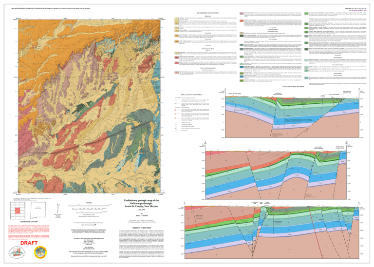
NEW MEXICO BUREAU OF GEOLOGY AND MINERAL RESOURCES A DIVISION OF NEW MEXICO INSTITUTE OF MINING AND TECHNOLOGY NMBGMR Open-file Geologic Map 30 Last Modified 26 October 2009 DESCRIPTION OF MAP UNITS Tgl Quaternary 106°00'00"W 35°30'00"N 411000 410000m E 105°57'30" 412000 QTa 8 Ts ? Qca Qa Qp 3928000m N Qp ? QTa A 418000 Ts 419000 Qca QTa Qa Qca Qca Qt Qca QTa @ ? Qa Ts QTa 88 76 Te 19 3927000 21 33 QTa QTa ? 16 C Tgu 23 Qca Qca Qp 21 QTa Qca Tgl 25 QTa QTa Qp 32 Te 14 12 36 8 38 14 14 15 14 Te 15 QTa Qa Te 16 14 Tgu 29 29 Qca Qca Te Tgl Qp Qca Tgl 3923000 Tgu 23 34 29 Tgl 42 Te Te 46 Tgu Qca Qp QTa 16 8 Te 17 22 13 Tgl 15 Te 17 Te 17 Te Tgu Qca 32 Tgl 15 Tgl 65 22 Kn2 Te 22 26 22 Te 14 Qp 21 3 35°25' 12 36 9 14 16 26 Td 64 62 75 50 24 3918000 26 69 39 24 88 38 29 Td 68 10 Qca Td Td 64 45 12 Qc Qc 35 Tgu Qa 24 76 21 Td 78 13 15 Kcj 7 13 13 Tdt 17 16 1-35 14 13 Qt 12 Tgl 12 17 Qt Kcj 14 Kns 18 15 18 Qa 7 Qt Qt 13 Qca Qt Qt Qt Qa 1-4 Qca 39 4 52 Qca 56 50 Qca Qa 33 3915000 Qca 18 Tdt Qca Tdt Qca 35°22'30"N 106°00'00"W 26 Kns Qca 20 10 5 11 Qca Qa 52 Tdt 10 25 Qt 18 Qt 7 Kdo 8 Kc 33 10 Kn1 Qca 4 60 Kns 33 17 Kcs Qa Qt Kn2 Kc Qca 414000 105°57'30" Kc 26 Kg Kn1 Kcj 412000 10 Qc 415000 6 Kn1 Kgr Kcj Kcs 10 Kcj Qt Qt Qc Qc Kns Qt Km 416000 Qt Qt Qc Kcj Qt Qt Qt Kcj Kc Qt Qt 417000 1:24,000 SALITRE CANYON BUFFALO SPRINGS 1 GALLEGOS NE NEW MEXICO ALAMOSA CANYON MEDINA MESA GALLEGOS Galisteo 0.5 1000 0 1000 0 2000 3000 1 MILE 4000 5000 6000 7000 FEET FUENTES RANCH 1 HAMPTON RANCH MONTESITO CREEK QUADRANGLE LOCATION This draft geologic map is preliminary and will undergo revision. It was produced from either scans of hand-drafted originals or from digitally drafted original maps and figures using a wide variety of software, and is currently in cartographic production. It is being distributed in this draft form as part of the bureau's Open-file map series (OFGM), due to high demand for current geologic map data in these areas where STATEMAP quadrangles are located, and it is the bureau's policy to disseminate geologic data to the public as soon as possible. After this map has undergone scientific peer review, editing, and final cartographic production adhering to bureau map standards, it will be released in our Geologic Map (GM) series. This final version will receive a new GM number and will supercede this preliminary open-file geologic map. DRAFT Magnetic Declination May, 2002 13º 0' East At Map Center 0.5 0 23 3 Kc 418000 NATIONAL GEODETIC VERTICAL DATUM OF 1929 [505] 835-5490 http://geoinfo.nmt.edu This and other STATEMAP quadrangles are (or soon will be) available for free download in both PDF and ArcGIS formats at: http://geoinfo.nmt.edu/publications/maps/geologic/ofgm/home.html 40 \ en ar ip -2,000' p ap -4,000' QTa QTa Te Te Qca Qca Qp Qca 16 Qt Kcj Kdp Qca 6 Kg Jm 0' MSL Kdo Kdo 419000 Qt Kn1 ? ? Kc-Kg-Kgr-Kdp Kd 4,000' &m/&s ? Jm ? ? Mp Je/Jt Pb/Psa/Pg 2,000' @c Py Pb/Psa/Pg @c Kd 0' MSL Py @c Pb/Psa/Pg Py Mp Py &m/&s \ Mp -4,000' Qca &m/&s May 1999 by Alvis L. Lisenbee South Dakota School of Mines and Technology, 501 E. Saint Joseph Street, Rapid City, SD 57701-3995 \ Pennsylvanian (?), Laramide, and Rio Grande rift deformation \ -6,000' -6,000' Los Angeles fault C North QTa 2-4 6,000 Feet (ASL) Te Qca Qca Lamy fault Kd Tgl Tdt A geologic map displays information on the distribution, nature, orientation, and age relationships of rock and deposits and the occurrence of structural features. Geologic and fault contacts are irregular surfaces that form boundaries between different types or ages of units. Data depicted on this geologic quadrangle map may be based on any of the following: reconnaissance field geologic mapping, compilation of published and unpublished work, and photogeologic interpretation. Locations of contacts are not surveyed, but are plotted by interpretation of the position of a given contact onto a topographic base map; therefore, the accuracy of contact locations depends on the scale of mapping and the interpretation of the geologist(s). Any enlargement of this map could cause misunderstanding in the detail of mapping and may result in erroneous interpretations. Site-specific conditions should be verified by detailed surface mapping or subsurface exploration. Topographic and cultural changes associated with recent development may not be shown. 0' MSL Cross sections are constructed based upon the interpretations of the author made from geologic mapping, and available geophysical, and subsurface (drillhole) data. Cross-sections should be used as an aid to understanding the general geologic framework of the map area, and not be the sole source of information for use in locating or designing wells, buildings, roads, or other man-made structures. -4,000' Kd Kd Jm Tdt Je/Jt Je/Jt Jm Thickness determined from TransOcean McKee #1 well Py @c Py Py -2,000' Pb/Psa/Pg 2,000' Py &m/&s &m/&s \ 0' MSL &m/ &s Mp Mp Mp @c &m/&s Mp Pb/Psa/Pg Py Py Pb/Psa/Pg 4,000' Py @c Kd 6,000 Feet (ASL) Pb/Psa/ Pg Py @c Mp Jm Kd Je/Jt @c Pb/Psa/Pg @c Jm Pb/Psa/Pg Je/Jt @c Kn1 Kc-Kg-Kgr-Kdp Je/Jt @c Jm Kc-Kg-Kgr-Kdp Jm Jm Qca Kns Kd Kns Kc-Kg-Kgr-Kdp @c Kn1 Kn1 Kn1 Je/Jt Kc-Kg-Kgr-Kdp Tdt Je/Jt Kn2 Kns Td Tdt Kns Jm Qca Qca Qca Kn1 Kc-Kg-Kgr-Kdp 2,000' C΄ South Kc-Kg-Kgr-Kdp Tgu Minimum thickness determined from Pelto #1 Ortiz well Lamy monocline Qca Te Tgl 4,000' Qca Kc-Kg-Kgr-Kdp The map has not been reviewed according to New Mexico Bureau of Geology and Mineral Resources standards. The contents of the report and map should not be considered final and complete until reviewed and published by the New Mexico Bureau of Geology and Mineral Resources. The views and conclusions contained in this document are those of the authors and should not be interpreted as necessarily representing the official policies, either expressed or implied, of the State of New Mexico, or the U.S. Government. -4,000' \ 35°22'30"N 105°52'30"W Preliminary geologic map of the Galisteo quadrangle, Santa Fe County, New Mexico. -2,000' Mp Pb/Psa/Pg 3915000m N \ &m/&s -2,000' Qca 420000m E Py &m/&s 3916000 8 Jm Jm 6,000' Je/Jt Kdo Jm ? Pb/Psa/Pg @c Jm Kc-Kg-Kgr-Kdp ? Kns Je/Jt Kd @c Km Kn2 Kn1 Jm Kc-Kg-KgrKdp Tdt Qa Qca Qca Qca Tdt Kc-Kg-Kgr-Kdp Kd Tgl @c 8 8 5 Qa Qp Tdt Tgu Tgu 2,000' Kgr 12 RD-3 Je/Jt Jm 75 18 20 RD-4 8,000 Feet (ASL) Glorieta Mesa boundary fault Lamy fault/ Lamy monocline 4,000' COMMENTS TO MAP USERS New Mexico Bureau of Geology and Mineral Resources New Mexico Tech 801 Leroy Place Socorro, New Mexico 87801-4796 \ Mp B΄ 6,000' Open-file Geologic Map 30 Mapping of this quadrangle was funded by a matching-funds grant from the STATEMAP program of the National Cooperative Geologic Mapping Act, administered by the U. S. Geological Survey, and by the New Mexico Bureau of Geology and Mineral Resources, (Dr. Peter A. Scholle, Director and State Geologist, Dr. J. Michael Timmons, Geologic Mapping Program Manager). &m/&s 8,000 Feet (ASL) Tgl New Mexico Bureau of Geology and Mineral Resources 0' South 1 KILOMETER CONTOUR INTERVAL 20 FEET Py td Mp Base map from U.S. Geological Survey 1966, from photographs taken 1958, field checked in 1964, edited in 1966. Polyconic porjection, 1927 North American datum, Projected to 1927 North American datum, UTM projection -- zone 13N 1000-meter Universal Transverse Mercator grid, zone 13, shown in red Thickness determined from Trans-Ocean McKee #1. Thickness differences inferred across the fault illustrate Pennsylvanian-age syn-tectonic deposition (after Booth, 1977) for Lamy-Canoncito area. North Kdo Qca Kcj Qt Qt Kc Kc 105°55' Mp Tdt Qca Kc 61 Qca Kcs? 18 72 Qt Kn2 Qca Tdt 9 411000 410000 Qt 29 12 20 Kn2 Kn1 Qt Mp 18 Qca Qca Qa Qa Qa Tdt 2,000' Pb/Psa/Pg Laramide-age fault may have lesser dip than reactivated Rio Grande rift fault Kgr J Kcj Qt Qc Qt &m/&s 3917000 Kdp Qa 3916000 @c -2,000' C' Kn1 Qca Qca Qa P&sc @c Kns 8 4,000' Py Je/Jt Tgl @c Qc Kcj Pb/Psa/Pg Jm Kd Je/Jt Py 6,000' @c o A' Kns Qt Qca Kc-Kg-Kgr-Kdp Qc Kcs Kcj Qt Qp Kn1 2,000' 2-4 Kcs Qca 26 Kn1 Kgr Qa Td -4,000' Qa Kc Qt many small faults Whigham Davis-Pinon 8,000 Feet (ASL) Glorieta Mesa boundary fault B 15 Kn2 A΄ 3919000 10 Qc Red-orange, dark brown, purplish gray and green, thick bedded mudstone, buff to dark red brown, cross bedded sandstone and limestone pebble conglomerate. Incomplete section exposed along western margin of Glorieta Mesa. Thickness in subsurface approximately 1850 ft. @c Kns &m/&s @c Kcs Qca McKee #1 12 Kcj Kn2 11 13 12 Jm Thickness from Booth (1977) Location and plunge direction of petrified log 3918000 Kc CHINLE GROUP Qca 6 Kcj Triassic Rocks Kn2 Tdt \ 18 20 Kc Entrada Formation — Rose, buff, and white, cross-bedded, quartz arenite. Extremely friable. Thickness approximately 100 ft in Ojo Hedionda quadrangle to south. Only the upper few feet are exposed in quadrangle. OD-1 Tdt 35°25' 18 Qca 15 Kcj Kcj Kns 23 21 16 Strike and dip of flow foliation Kns 12 17 Je Kn1 Kcj Kn2 Tdt 20 Strike and dip of bedding 8 @c Kc Kc RD-3 0' 25 21 Qp RD-2 6 12 Kc Kc Kc-Kg-Kgr-Kdp 4,000' Well drill hole Qp Kc Kn2 Tdt 24 3920000 6 Kns Kc Kcj 13 Qc 8 55 36 14 47 11 Qc 12 22 30 68 65 18 Todilto Formation — Light grayish-brown limestone: laminated and crenulated with fetid odor on fresh surface. Overlain by thin bedded, dark-gray limestone containing red jasper nodules. Thickness 40-50 ft (Booth 1977). Lamy fault/ Lamy monocline @c Conglomeratic zones 12 38 55 Qca Kc 14 65 13 Jt Fairport Shale Member — Calcareous shale, bentonite, and minor limestone with concretions. Not exposed in quadrangle but approximately 188 ft thick in Ojo Hedionda Quadrangle to south. Trace of axial plane of monocline, dashed where approximately known, dotted where concealed, plunging if arrow at the end of line shows direction of plunge. Qa 43 61 18 65 10 30 Kn2 Qp Kc Kcj 18 Qp 5 Kn1 26 Qca Kn2 5 24 3921000 16 Qp 13 68 5 Kcj Kns Qca 77 18 Kns 6 12 Kc Semilla Sandstone Member — Fine- to very fine-grained, thin bedded, bedding-parallel, bioturbated quartz arenite and interbedded shale. Three to 10 ft thick. Generally poorly exposed. Contains abundant fossils including Prionocyclus hyatti, Carota dalli, and Pinna Kaufmani. Pb/Psa/Pg Trace of axial plane of syncline, dashed where approximately known, dotted where concealed, plunging if arrow at the end of line shows direction of plunge. 26 Qp Qca Qa 12 Kn1 8 Kcs Kd Trace of axial plane of anticline, dashed where approximately known, dotted where concealed, plunging if arrow at the end of line shows direction of plunge. 12 12 5 Blue Hill Member — Dark-gray shale. Three zones of septarian concretions (3 ft) weather to rubble: Enclosing shale rarely exposed. Thickness ~160 ft. Fossils include Ptychodus whipplei and Cretolamna appendiculata. 6,000' Dip of fault or dike 3 34 Location of geologic cross section. Normal fault, ball-and-bar on downthrown side. Solid where exposed, dashed where approximately known, dotted where concealed. @c 10 61 66 Kns Kn1 83 3922000 81 Kn1 10 Kcb QTa Geologic contact. Solid where exposed or known, dashed where approximately known, dotted where concealed or inferred. 7 Qa Qca Td Td 21 15 Tdt 9 Tdt 9 7 Kns 17 Kn2 A' 13 25 Td 14 17 Kns 14 Kns 12 12 Kn1 6 10 10 Kns 13 89 75 4 Td 12 19 16 Kn2 14 Td 77 7 Pinon No. 2 SAN RAPHAEL GROUP Juana Lopez Member — Regression R-1 of Molenaar (1983). Brown-gray platy, interbedded fossiliferous quartz arenite, calcarenite (commonly composed of needle-like fragments of Inoceramus shells), calcareous gray shale and gray shale. Ratio of carbonate to sand varies greatly along strike. Forms low ridges. Abundantly fossiliferous with Lopha lugubris, Prionocyclus hyatti, Cretolamna appendiculata, Prionocyclus novimexicanus, Scaphites whitfieldi, and Inoceramus perplexus. The later three fossils indicate an early Late Turonian age. Thickness ~65 ft. Sangre de Cristo uplift EXPLANATION OF MAP SYMBOLS 11 @c Td Td Kn2 Kn1 Qca Qt Td 84 77 73 77 26.5 19 Qca Qca Qca 85 57 Tdt 23 26 80 75 75 1-34 17 3917000 88 67 72 76 Qca 23 13 21 Qa Td Qa Td Td 32 78 Tdt 22 Kns Qca Td 80 14 Qca 38 28 22 13 Thin shale — Approximately 50 ft of calcareous Carlisle shale lies above the Juana Lopez Member, although the latter is the mapping top for this study. South 8,000 Feet (ASL) 28 Kns Kn2 17 13 18 Pinon No. 1 Morrison Formation — Upper portion of the section is white, kaolin-bearing sandstone (Jackpile) underlain by green, gray and maroon mudstone, interbedded tan and light red-brown sandstone, and lenses of tan and white pebble conglomerate. Sandstone is fine grained, subangular to subrounded quartz and minor chert and feldspar. Bedding is platy to massive and cross beds are common. Thickness undetermined. Jm North 3923000 8 35 Qc 5 Jurassic Rocks A 5 5 Unconformity Lower shale member — Montezuma Shale Member of Mancos Shale. Medium gray, calcareous shale; weathers olive-brown. Poorly exposed, mostly in arroyos. Thickness approximately 250 ft based on cross section. GEOLOGIC CROSS SECTIONS Qca 4 Dakota Sandstone (Romeroville, Cubero and Oak Creek Members, undivided) — In southeastern portion of quadrangle lower and upper, tan to orange-brown, fine- to medium-grained, medium- to thick-bedded, bioturbated, including scolithus, quartz arenite: middle portion consists of sandstone and variegated siltstone or, locally, gray shale and highly carbonaceous black shale interbedded with thin lenses of tan sandstone, commonly containing fragments of coal: thickness approximately 49 ft in southeast. In Lamy area thickness varies from 1 to 20 ft of thin-bedded, fine-grained, bioturbated quartz arenite. Kdo Map units exposed only in cross sections are omitted due to space limitations, but are described in the accompanying report. References cited are found in the report as well. Kn2 Kn1 Kns Sandstone member — Cano Tongue of Stearns (1953). Combined Hosta-Dalton Member, Mulatto Tongue, and El Vado Sandstone of the Mancos Shale, based upon fossil identification of Varriale (2003). Regression R-3 of Molenaar (1983). Light olive-gray, even bedded, fine-grained, thin-bedded, bioturbated, ripple marked, calcareous quartz arenite and interbedded yellowish-gray siltstone. Weathers to a low, broad, rounded ridge covered by sandstone chips. Thickness approximately 400 ft in cross section. Placenticeras guadalupae (Roemer), P. pseudocostatum (Johnson), P. planum (Hyatt), Turitella aff, Codellana, Gyrodes conradi, Deussinia novamexicana, Ptchodus mortoni. 4 12 8 Td 27 Qt Td Tgl 60 14 Qca 43 43 Td Qt2 Qca Kn1 Kns Kn2 Qca 9 9 Qt 12 1-26 18 68 Kn1 Qp 35 45 A 78 14 Kns Qca Qca 29 72 74 Qca 29 27 Tgu 33 Tgu Qc Qa 11 83 Kc Graneros Shale (Clay Mesa Shale Member) — Light gray and black, silty shale, limestone, quartz arenite lenses, numerous bentonite layers, and large limestone (to 3 ft) and cone-in-cone concretions. A zone of calcareous concretions to 12 ft diameter is present in the basal portion. Weathers to grass-covered prairie. Abundant fossils include Acanthoceras amphibolum (Morrow), Tarrantoceras sellardsi (Adkins), Cretoxyrhina mantelli (Agassiz), Cretodus semiplicatus (Munster), Squalicoras curvatus, Squalicoras falcatus (Agassiz) and Ptychodus occidentalis (Leidy). Thickness 83 ft at Lamy (Lucas, 2002) and Hub Canyon in Ojo Hedionda Quadrangle. Kgr Carlisle Shale — In ascending order the unit contains: The Fairport Shale Member; the Semilla Sandstone member; the Blue Hill Shale Member; the Juana Lopez member; a thin shale. Shale units are dark gray to black, thinly laminated, and weather to a yellow-brown color. Kcj Galisteo Formation, upper unit — Tan to white, massively bedded, friable, well sorted, cross bedded sandstone and interbeds of red, rose, tan, and gray-green mudstone. Contains silicified logs to four ft diameter and 30 ft lengths. Thickness 346 ft in uranium drill hole #2-4 and 425 ft in drill hole 1-35. Qca 4 11 Espinaso Volcanics — Buff, grayish purple and reddish brown beds of agglomerate, tuff, and volcaniclastic sandstone of intermediate composition and of alluvial fan and laharic origin. Source areas are the Cerrillos Hills and Ortiz Mountains intrusive centers. Conformable with underlying Galisteo Formation. Comprises approximately 1000 ft maximum thickness in quadrangle. Kn1 Dakota Sandstone (Paguate Sandstone Member) — Buff to kakhi, bioturbated, fine to medium grained, thin bedded quartz arenite with three or less bentonite beds. Alternations of gray and brown shale and sandstone give outcrops in arroyos banded appearance. Fossils include Acanthoceras amphibolum, Tarrantoceras sellardsi, Turrilites acutus americanus, Aphrodina cf. A. munda (Stephenson), Ostrea beloiti (Logan) and Inoceramus rutherfordi (Warren). Forms low questa. Thickness 17 to 40 feet in the Lamy area and 23 feet in the southeast. Transitional lower contact with Clay Mesa Shale Member. Kdp Upper shale member — Satan Tongue of the Mancos Shale. Medium gray, calcareous shale; weathers olive-brown. Contains abundant concretions to three feet diameter: Gradational to the Point Lookout Sandstone. Poorly exposed, mostly in arroyos. Contains Cordiceramus muilleri, Crassatella pluchella, Cladoceramus undulatoplicatus. The thickness, based on cross section, is approximately 300 ft. @c 4 Qt Qt Galisteo Dike (micro-monzonite) — Dark gray fine grained, salt and pepper mixture of plagioclase, potassium feldspar, titan-augite, titaniferous biotite, apatite, and opaque grains in a glass groundmass. Weathers dark brown or grayish brown and stands as wall-like rampart. The dike, in map view, comprises many right echelon overlapping segments varying from 200-1200 ft in length and up to 18 ft thick. 26.55 Ma. (Erslev, 2001). Kcf Qa 11 Sill/laccolith — Latite porphyry. Dark purplish-brown, porphyritic mixture of plagioclase, potassium feldspar, titaniferous augite, titaniferous biotite, apatite, and magnetite in a glassy groundmass. Weathers dark brown. Thickness unknown. 32.5+/-1.1 Ma (Peters, 2001). 12 Qca Kns Kns Qca Qa Qca Tertiary Igneous Rocks 35°27'30" Qc 8 Tdt Tdt 35 Tdt Qt 22 Qa 26 Tgu Td 30 11 9 Qca Qca 20 47 43 Qa 15 6 Qca Qc 62 Qp Qp 18 Tdt Qc Tgu Qt Qca Kn2 Late Paleocene to Eocene 8 Qp Qa Niobrara Formation — Comprised of upper (Kn2) and lower (Kn1) shale units and an intervening sandstone/sandy-shale (Kns). Fossils defined by Varriale (2003). Tertiary Sedimentary Rocks 50 Qp 41 27 Qa 65 86 21 11 Qc 45 26 Qc 57 Qca Qp 16 Qp 15 36 41 Kns Tdt Qc Qc 25 27 55 65 3925000 Qt Kn2 60 62 18 Tdt 80 Qt 35 24 19 27 Tdt 10 Te Kns 37 12 31 12 Qp Qa 50 36 20 Te 17 27 45 Tgu 12 16 Te Qca OD-1 Qp 38 19 20 Qca 11 16 3919000 38 Tgu 36 QTac Kns 49 Qp 49 74 68 Kns 23 Qc 8 Tgl 77 40 13 Kns 42 Kn1 Qc 60 Te Qt Kn1 57 51 60 QTac QTac 10 6 39 4 Qp 7 10 QTac Tdt Td @c 23 Qt Ancha or Tesuque channel — Calcite cemented (20% to 95%) arkose or arkosic limestone overlain by medium to very coarse grained arkosic sand and red silt. Contains numerous rod-shaped zones of caliche-cemented arkose, probably formed by precipitation from groundwater. B' Qt Qp 47 Tdt 68 Qc Qp Qp 16 31 45 16 16 7 Qt 16 Qca Kn1 Kn1 Kc Tdt Kn2 12 Kdo 28 Qt MANCOS GROUP 23 38 Tdt Ts Kpl Tdt Qt 3926000 59 28 39 Qls 15 12 Qp 44 9 Qca 30 32 52 38 Kg Kcj Qp 19 21 17 13 3920000 6 Te Qca 30 37 Tgu 21 Kgr Qc Qca 32 Tgl Qp 30 13 Qt 10 39 Kc Tdt 47 24 36 29 Tdt Unconformity Unconformity Graneros Shale (Whitewater Arroyo Shale Member) — Tan, gray, and black, calcareous shale and thin lenses of fine-grained, calcareously cemented, tan and brown sandstone. Weathers to grass-covered prairie. Thickness 40 to 80 ft in Lamy area and 108 ft in southeast corner of quadrangle where the Two Wells is absent. Kgr Point Lookout Sandstone — Buff and dark brown to olive, fine- to medium- grained, massive bedded sandstone and fossiliferous brown mudstone containing calcite-cemented concretions. Truncated thickness ranges from 0-60 ft beneath angular unconformity. The lower contact is gradational with the upper Mancos Shale (Satan Tongue). Oligocene Kn2 Qt MESAVERDE GROUP Kpl 12 Qca 36 Qt Tdt Qa Kc Kc 21 Kdo 10 Qt Qca Kn2 58 22 Kns 2 Tdt 22 Qca Qt QTac Qt Dakota Sandstone (Twowells Member) — Tan quartz arenite, medium to course-grained with quartz and chert. Shell fragments and vertical burrows. Medium to thick bedded, some with cross beds. Twenty four feet thick at Lamy. Absent in southern portion of quadrangle. Cretaceous Rocks Ancha Formation — Buff to moderate orange pink and grayish pink, generally poorly sorted and poorly consolidated beds of sand, gravel and cobbles. Derived from Precambrian granitic and metamorphic and Paleozoic sedimentary terrains in the Sangre de Cristo Mountains. Strongly cemented by caliche near Lamy. Thickness to 18 m (60 ft). 33 Tdt Kn1 49 Kc Kgr 88 36 28 12 Qt Kn1 41 84 18 Qt Kns 52 Tgl Kn1 15 y a Kc 27 Kc Tdt 50 Tgl Qca 26 20 37 L am F 3927000 Graneros Shale (Lincoln and Hartland Members?) — Tan, gray, and black, calcareous shale and thin lenses of fine-grained, calcareously cemented, tan and brown sandstone. Alternations of gray and brown shale and sandstone give outcrops in arroyos banded appearance. Thickness 66 ft at Lamy. Kgr Kdt Divided into two formations. The thickness decreases northward due to regional erosion surface. Qca Kns Kn2 45 Qt 79 60 16 Kgh Kdo 67 Kgr Kgr 8 Kc Kcj Kc Kcj 18 Qca 9 10 Qa Tgl Kdo 22 27 Qp Tgl 23 24 Tgl Kns Tdt Qca Kc Kc 60 Tdt Qa Qc Qa Kgr The Dakota Sandstone and Graneros Shale are intertonguing units. The Dakota Sandstone is divisible into three sandstone tongues (Two Wells, Paguate, and the combined Cubrero, Oak Canyon, and Romeroville) separated by the Clay Mesa and Whitewater Arroyo members (Lucas et al., 1998; Lucas, 2000). Unconformity Km Kdp 37 Kc Qt Qa Tdt 19 36 22 12 38 34 26 Tdt Qc Kgr Kdt Kg Qc Qp 30 Kc Kdt Qt Qp Qca Kc Kgr Kg 36 QTa 45 Greenhorn Limestone (Bridgeport Limestone Member) — Alternating beds of dark-gray, argillaceous micrite and medium- to darkgray calcareous shale. Most beds are less than 1.5 ft thick. Weathers light-gray and forms a low ridge. Imprints of Inoceramus labiatus are common as are foraminifera. Thickness is approximately 50 ft. Kg Diamond Tail Formation — Variegated sandstone, conglomerate, mudstone and local limestone beds. Sandstone beds are massive, friable, usually cross bedded and composed of medium- to coarse-grained, subrounded, poorly sorted quartz and lesser chert. Kaolin, limonite, or calcite commonly constitute the matrix. Colors are tan, brown, orange, pink, red and white. Mudstones are gray to red in color and poorly exposed. A thin, basal conglomeratic zone containing brightly colored chert is commonly present. At Lamy the section in dominantly sandstone: Stone from a quarry on the south side of Cerro Colorado was used to construct St. Michaels Cathedral in Santa Fe. Maximum thickness approximately 1000 ft. Unconformity Kns 8 t ul 18 Tgl Qa 18 Qp Kgr 46 RD-3 Qp 52 57 Tgl 14 34 Qca 21 18 QTa 11 85 38 25 Qp Tgl Qp 8 7 Kg 12 3921000 10 8 Tgl Qca Tgl 14 Tgl Tgl RD-4 8 14 Tgl Qca 16 12 21 5 Tgl Qp Qp Qca 13 17 17 31 33 Kdt Kg Kgr Kg RD-1 7 8 Tgl Tgl Pediment deposits — Cobble, pebble, sand and silt deposits lying upon remnants of an extensive surface cut to a former channel level of Galisteo Creek. Thickness generally less that 10 ft. 37 Kdt Kdp Kg 61 8 Tgl 23 65 Tgl Tgl 12 Qp QTa Tgu 3922000 18 17 Tgl 8 14 20 59 Kgr 17 Tdt 55 14 Qp 12 Qa 65 Kdo 24 Qp Qp Tdt 18 Tgl Qp Kdp 15 Qca Tgl Kc Kg RD-2 Qp 10 32 30 17 29 42 41 Kgr Kdt Tdt 10 QTa Qp 19 Tgl 8 16 Jm Kdo Qp Kdp Tdt Tgl Tgl 28 Kdo Kdo Jm 54 Qca Kdo Jm 28 Qp Qp 12 35 26 Kdo Kgr Qp Jm 30 2 17 14 18 6 21 7 Qca Qp 18 Qp Tgl 16 9 Qca 34 24 2 Tgl Tgl 17 Qa Tdt 19 9 Tgl Te 20 18 Qa Qp Jm 17 Qp 19 15 Qp Jm 23 44 Kdp Kgr Qls 19 Qca Jm Qp Qca Kdp Qp 4 Kgr QTa Jm 15 19 Qp Qp Jm Jm Qca 12 Tgl Kgr Kdp Qca 17 Kdo Kgr 17 Qp 17 15 7 Qp 55 21 5 29 13 Qca 14 8 Kgr Qca Tgl 6 32 Jm Qca 10 Qca Qp 14 Kgr 26 Tgl Te Qca Qp Kdo Tgl 16 34 Tgl 22 24 18 9 Jm Qp 36 16 Jm Qp 55 22 Qca 35°27'30" 21 16 Jm Tgl QTa 13 15 28 13 34 Qca 34 Qca 3925000 Tdt 16 Jm 10 Kgr Qp QTa 2-4 B Qp 65 29 Te QTa 71 38 Tgu 36 15 Kgr Jm 34 Qp Terrace gravel — Rounded pebbles and cobbles of Precambrian granite, commonly containing abundant epidote, granite pegmatite, muscovite and biotite schist, and Phanerozoic chert and sandstone in a sand or silt matrix. Terraces generally lie 20 to 40 ft above valley floors. Qp Qca 14 29 Jm Jm 33 49 16 Kdo 30 Qp 19 15 12 25 15 38 36 12 14 36 81 37 16 Jt Qp Qca Qp Jm 16 18 6 QTa 15 15 37 Qp Qp Tgl 12 12 Jm Qca Qp 49 46 20 Qp Qa Qp 3926000 Qca 13 Qp 27 8 Qp Tgu ? Qp 40 37 1-35 Te 14 12 Tgl Te Qp 15 Jm 19 Tdt Colluvium/alluvium — Sand, silt and clay in abandoned stream channels, flood plains, and lower valley slopes. Colluvium — Unconsolidated sand, silt and clay deposits along upper hill slopes or broad, flat hill crests. A few meters in maximum thickness. Jt Je Jm Jm 31 @ Jt Je Je Qa Ts 7 32 QTa ? ? Qca Te Je Jt Alluvium — Cobbles, sand, silt, and clay transported by seasonal flooding or in active channels. Coarser clasts are dominated by quartz and granitic material. Qc QTa Qp Qca 3928000 QTa Qa 7 Qca Qa Ts 13 Qa QTa Qa Qa Qca 105°52'30"W 35°30'00"N 420000 Qa Qca Ts 32.5 Qca ? Qp ? Qa Ts 105°55' 416000 Qca ? ? Qa 415000 QTa Qca ? QTa 414000 Galisteo Formation, lower unit — Alternating pink- to red-colored beds of arkosic sandstone, siltstone, and mudstone with extensive lenses of conglomerate. The conglomerate beds contain rounded cobbles and pebbles of Precambrian granite and schist and Paleozoic sedimentary rocks in which the relative percentage of Precambrian clasts increases upward through the section. Thickness approximately 3,500 ft. Mp &m/&s \ -2,000' &m/&s \ Py Pb/Psa/Pg &m/&s Mp \ Mp \ &m/&s -4,000' \ -6,000' Mp \ -6,000' Td

