New Mexico National Cooperative Geologic Mapping Program STATEMAP Component:
advertisement
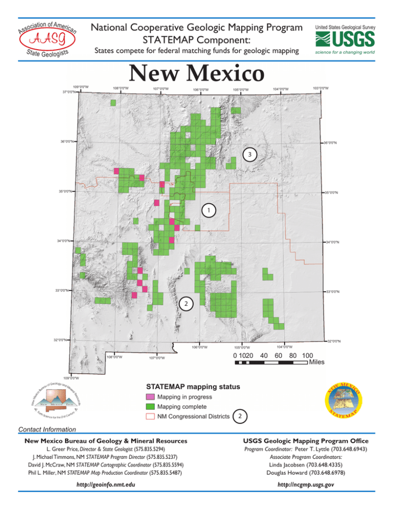
As tion of Americ socia an S ta te G National Cooperative Geologic Mapping Program STATEMAP Component: States compete for federal matching funds for geologic mapping e ol o g is t s 109°0'0"W 37°0'0"N New Mexico 108°0'0"W 107°0'0"W 106°0'0"W 105°0'0"W United States Geological Survey science for a changing world 103°0'0"W 104°0'0"W 36°0'0"N 36°0'0"N 3 35°0'0"N 35°0'0"N 1 34°0'0"N 34°0'0"N 33°0'0"N 33°0'0"N 2 32°0'0"N 32°0'0"N 106°0'0"W 108°0'0"W 107°0'0"W 104°0'0"W 105°0'0"W 0 1020 40 60 80 100 Miles 109°0'0"W STATEMAP mapping status Mapping in progress Mapping complete NM Congressional Districts 2 Contact Information New Mexico Bureau of Geology & Mineral Resources USGS Geologic Mapping Program Office L. Greer Price, Director & State Geologist (575.835.5294) J. Michael Timmons, NM STATEMAP Program Director (575.835.5237) David J. McCraw, NM STATEMAP Cartographic Coordinator (575.835.5594) Phil L. Miller, NM STATEMAP Map Production Coordinator (575.835.5487) Program Coordinator: Peter T. Lyttle (703.648.6943) Associate Program Coordinators: Linda Jacobsen (703.648.4335) Douglas Howard (703.648.6978) http://geoinfo.nmt.edu http://ncgmp.usgs.gov SUMMARY OF STATEMAP GEOLOGIC MAPPING PROGRAM IN NEW MEXICO Federal No. of fiscal quads year(s) mapped 1993-99 41.5 2000-05 88.5 2006-09 57 2010-12 30 2013 5.5 TOTALS 222.5 Federal NMBGMR Dollars Dollars awarded to matched NMBGMR 7.5-minute geologic quadrangles mapped Tijeras, Albuquerque East, Placitas, Sandia Crest, Sandia Park, Hubbell Spring, McClure Reservoir, Isleta, Alameda,Taos SW, Mt. Washington, Sky Village SE, Jemez Pueblo, Santo Domingo Pueblo, Glorieta, Albuquerque West, Bernalillo, San Ysidro, San Felipe Pueblo, Dalies, Carson, Sedillo, Seton Village, Bosque Peak, Loma Creston, Santo Domingo Pueblo SW, San Pedro, Galisteo, Socorro, Edgewood, San Felipe Pueblo NE, Santa Fe,Veguita, Ranchos de Taos, Rosilla Peak, Turquoise Hill, Golden, Frijoles, Ojo Hedionda, Captain Davis Mtn. (1/2), Lemitar (1/2), Capilla Peak (1/2), Taos (1/2), Madrid (1/2). Captain Davis Mtn. (1/2), Lemitar (1/2), Capilla Peak (1/2), Taos (1/2), Madrid (1/2), Horcado Ranch, Guaje Mtn., Pecos, Picture Rock, Hagan, Escabosa, Cañada, San Antonio, Luis Lopez, Española, Cundiyo, Ponderosa, Los Cordovas, Peñasco, Manzano Peak, Capilla Peak, Carlsbad West, Carlsbad East, Kellog Well, Oak Peak, Dusty, Welty Hill, Wahoo Ranch, Montoya Butte, Jemez Springs, Bear Springs Peak, Chimayo, San Juan Pueblo,Velarde, Silver Creek, Otis, Loving, Las Vegas, Las Vegas NW, Farmington North, San Lorenzo Spring, Chilili, Truchas, Bland, Belen, Medanales, Lyden, Tome, Tome NE, Mesa del Yeso, Seven Springs, Cerro del Grant, Polvadera Peak, Ojo Caliente, La Joya, Becker, Scholle, Ruidoso, Angus, Ruidoso Downs, Seven Rivers, Chili, Trampas,Youngsville, Cañones,Vallecitos, El Valle, Tome SE, Loma de las Canas, Arroyo Hondo, King Draw, Water Canyon, Lake McMillan South, Fort Stanton, Holt Mountain, Arroyo del Agua, Jarosa, Ghost Ranch, Abeytas,Valle Toledo,Valle San Antonio, Chise, Baldy Mountain, Bottomless Lakes, Ojitos Frios, Abreu Canyon, Reserve, Luna, Ladron Peak (1/2), La Madera (1/2), Taos Junction (1/2), Tres Ritos (1/2), Sierra de la Cruz (1/2), La Joya NW (1/2). Ladron Peak (1/2), La Madera (1/2), Taos Junction (1/2), Tres Ritos (1/2), Sierra de la Cruz (1/2), La Joya NW (1/2), Canjilon SE, White Rock, Fort Bayard, Welty Hill, Bay Buck Peaks, Canon Agua Buena, Carbon Springs, Guadelupe Mountain, El Rito, Silver City, Bitter Lake, Alamogordo North, Lake McMillan North, South Spring, Table Mountain, Flying H NW, Loco Canyon, Elk, Thimble Canyon, Robertson Canyon, Dunken, Tularosa, Sabinata Flat, Cat Mountain, Tularosa NE,Valle Grande Peak, Lobo Springs, Servilleta Plaza, Mount Taylor, Three Rivers, Lincoln, San Patricio, Chimney Lake, Lewis Peak, Cornucopia Canyon, Piñon Ranch, Nogal, Capitan, Nelson Canyon West, Oscura, Arroyo Seco, Las Tablas, Indian Well Wilderness, San Mateo, Cerro Pelon, Ambrosia Lake, Capitan Pass, Capitan Peak, Bull Gap, Carrizozo East, San Lucas Dam, Nogal Peak (1/2), Godfrey Peak (1/2), Cub Mountain (1/2), Dayton (1/2), Artesia (1/2), Spring Lake (1/2). Nogal Peak (1/2), Godfrey Peak (1/2), Cub Mountain (1/2), Dayton (1/2), Artesia (1/2), Spring Lake (1/2), Church Mountain, White Oaks South, Monica Saddle, C-N Lake, Dos Lomas, Cañon Plaza, Luera Mountains East, La Mesita Negra, Grants, Seboyeta, Sierra de la Cruz, San Antonio SE, Iron Mountain, Winston, Becker SW, Questa, Milan, San Rafael, Huerfano Hill, Cienega Ranch, Bluewater, Goat Mountain, Grants SE, Cerro Montoso (1/2), Bustos Well (1/2), Hillsboro (1/2), South Garcia SE (1/2), Benavidez Ranch (1/2), Black Butte (1/2), Monticello (1/2), Laguna Canoneros (1/2). Cerro Montoso (1/2), Bustos Well (1/2), Hillsboro (1/2), South Garcia SE (1/2), Benavidez Ranch (1/2), Black Butte (1/2), Monticello (1/2), Laguna Canoneros (1/2), Williamsburg (1/2), Williamsburg NW (1/2), Thoreau NE (1/2) Modern digital geologic maps are essential for New Mexico's environmental and economic prosperity. Geologic maps are uniquely suited to solving problems involving Earth resources, hazards, and environments, and perhaps most importantly for the people of New Mexico, such maps help identify and protect ground water aquifers, aid in locating water-supply wells, and are fundamental for all environmental studies and land-use plans. One of the primary objectives of the New Mexico Bureau of Geology and Mineral Resources is to characterize the state's geology in sufficient detail to allow governments, communities, planners, and scientists to use these map data in matters of practical economic, environmental, and basic scientific concerns. The bureau's mapping program is cooperative in the broadest sense; STATEMAP priorities are set annually by the 40+ member N.M. STATEMAP Advisory Committee, comprised of professionals from federal, tribal, state, and local agencies, as well as private industry. STATEMENT OF OUTCOME: Of the 121,598 sq. miles of New Mexico, about 35% has been mapped at a scale of 1:24,000: In total, 712 quadrangles have been produced by the bureau and USGS efforts over the history of these agencies. Of that number, approximately 217 quadrangles have been completed under the 20 year history of the NM STATEMAP Program, indicating a dramatic increase in mapping activity and efficiency. Few of these pre-STATEMAP quadrangles are located within the metropolitan corridors, and very few are mapped well enough to satisfy the current needs of hydrologists, engineers, land-use managers, and planners. The most critical area is the populated Total Project Dollars $720,755 $720,886 $1,441,641 $1,642,483 $1,685,597 $3,328,080 $900,645 $1,152,680 $2,053,325 $656,537 $701,573 $1,358,110 $153,110 $157,389 $310,499 $4,073,530 $4,418,125 $8,491,655 zone along the Rio Grande watershed from the Colorado border to Elephant Butte Reservoir, which contains 50+% of the state's population on 5% of its land area. Rapid population growth, shallow alluvial aquifers, large topographic relief, and the alternating scarcity and abundance of precipitation, give rise to a host of hydrologic and engineering problems here. Due to these concerns, the N.M. Office of the State Engineer, among other state agencies, many New Mexico counties, and several pueblo tribes conduct hydrologic studies to determine water resource availability, protect existing water rights, and plan for continued growth in the region. Increasing consumption of surface and ground waters by a growing population, a continuing long-term regional drought, and the competing needs of municipalities, agriculture and endangered species in riverine ecosystems, make geologic and hydrologic data collection and interpretation a critical need for the state. Because much of the state's water is produced from Tertiary sedimentary basins, a thorough geologic understanding of these basins is essential to develop accurate models and management tools for water planning and administration. For recent geologic map compilations used in New Mexico’s population centers, see Open-file reports OFR-481 and OFR-496. Other map compilations include the Ruidoso area (OFR-507) and Sacramento Mountains (OFR-512), areas also undergoing rapid growth with limited water resources. These can be found at: http://geoinfo.nmt.edu/publications/maps/geologic/home.html Last Revised: 12 September 2013
