Chapter 13 – Middle Latitude Cyclones Fig 13.1 a)
advertisement
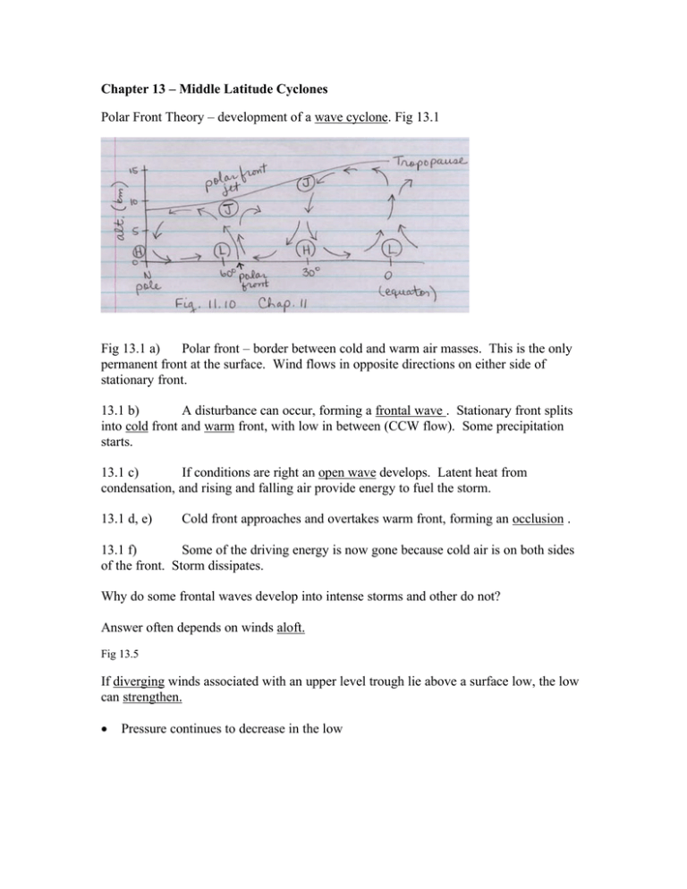
Chapter 13 – Middle Latitude Cyclones Polar Front Theory – development of a wave cyclone. Fig 13.1 Fig 13.1 a) Polar front – border between cold and warm air masses. This is the only permanent front at the surface. Wind flows in opposite directions on either side of stationary front. 13.1 b) A disturbance can occur, forming a frontal wave . Stationary front splits into cold front and warm front, with low in between (CCW flow). Some precipitation starts. 13.1 c) If conditions are right an open wave develops. Latent heat from condensation, and rising and falling air provide energy to fuel the storm. 13.1 d, e) Cold front approaches and overtakes warm front, forming an occlusion . 13.1 f) Some of the driving energy is now gone because cold air is on both sides of the front. Storm dissipates. Why do some frontal waves develop into intense storms and other do not? Answer often depends on winds aloft. Fig 13.5 If diverging winds associated with an upper level trough lie above a surface low, the low can strengthen. • Pressure continues to decrease in the low L CON Wind DIV isobars H Aloft, winds tends to be parallel to isobars. If isobars converge, air gets more dense, if isobars diverge, air gets less dense. Less dense air aloft in an area of divergence can suck air up from the surface, intensifying a low. Divergence aloft can also result from a change in wind speed. PGF H air coriolis Centripetal force = Fcor - PGF Centripetal force = PGF - Fcor L PGF Coriolis force is greater near a high, for equal PGF air coriolis ⇒ Wind speed is greater near a high Upper level waves 500 mb map of Northern Hemisphere 5 large waves are longwaves wavelength This pattern is stationary or slowly moving Superimposed on longwaves are shortwaves, which move eastward rather quickly ~ 25 mph. When a shortwave meets a longwave trough, a deeper trough develops. Near deep troughs, isotherms tend to cut across isobars (a baroclinic condition). Barotropic ⇒ isotherms are parallel to isobars Baroclinic instability - brings colder air into trough, makes air more dense and lowers contours (isobars) which deepens trough. On left side of trough: • Air is cooling • Air is converging and becoming more dense • Air falls to surface adding to cold high pressure behind cold front • Cooler air deepens trough • Sinking air adds kinetic energy to storm On right side of trough: • Air is warming • Air is diverging and getting less dense • Air rises, creating a low at surface • Warmer air raises ridge • Latent heat from condensation in rising air adds energy to storm Eventually, storm occludes, low aloft forms over surface low, shortwave moves out of trough, energy that fueled storm dies out. Read about “Storm of the Century”, March 13, 1993. Vorticity Vorticity is spin and can be useful in locating areas of convergence and divergence, hence where storms will form. Top view : CCW spin ⇒ positive vorticity CW spin ⇒ negative vorticity In northern hemisphere, earth’s vorticity is positive Depends on latitude: ζa is absolute vorticity = sum of earth’s vorticity and relative vorticity Vorticity can be observed by satellite using IR water vapor detectors (See Fig. 13.22). Maximum vorticity means center of upper level trough ⇒ a surface low to east of vorticity max is likely to develop into larger storm. Polar Lows Similar to hurricanes in some ways (See Fig 13.25) Polar lows form when very cold air from frozen Arctic Ocean regions moves over warmer areas of ocean currents. Warmer air rises and colder air falls, creating instability. If an upper level shortwave encounters a trough just west of the surface low, a polar low may develop.
