Effects of local farming and deforestation on tropical freshwater streams:... of stream geomorphology and fine clastic particle size, distribution, and...
advertisement

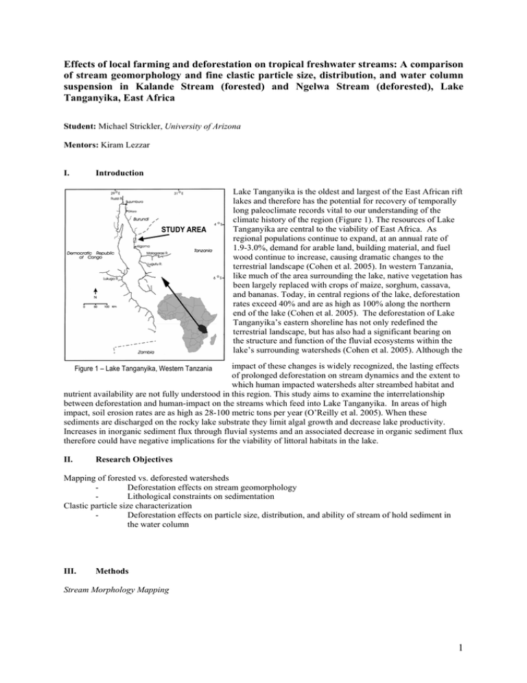
Effects of local farming and deforestation on tropical freshwater streams: A comparison of stream geomorphology and fine clastic particle size, distribution, and water column suspension in Kalande Stream (forested) and Ngelwa Stream (deforested), Lake Tanganyika, East Africa Student: Michael Strickler, University of Arizona Mentors: Kiram Lezzar I. Introduction Lake Tanganyika is the oldest and largest of the East African rift lakes and therefore has the potential for recovery of temporally long paleoclimate records vital to our understanding of the climate history of the region (Figure 1). The resources of Lake Tanganyika are central to the viability of East Africa. As regional populations continue to expand, at an annual rate of 1.9-3.0%, demand for arable land, building material, and fuel wood continue to increase, causing dramatic changes to the terrestrial landscape (Cohen et al. 2005). In western Tanzania, like much of the area surrounding the lake, native vegetation has been largely replaced with crops of maize, sorghum, cassava, and bananas. Today, in central regions of the lake, deforestation rates exceed 40% and are as high as 100% along the northern end of the lake (Cohen et al. 2005). The deforestation of Lake Tanganyika’s eastern shoreline has not only redefined the terrestrial landscape, but has also had a significant bearing on the structure and function of the fluvial ecosystems within the lake’s surrounding watersheds (Cohen et al. 2005). Although the impact of these changes is widely recognized, the lasting effects of prolonged deforestation on stream dynamics and the extent to which human impacted watersheds alter streambed habitat and nutrient availability are not fully understood in this region. This study aims to examine the interrelationship between deforestation and human-impact on the streams which feed into Lake Tanganyika. In areas of high impact, soil erosion rates are as high as 28-100 metric tons per year (O’Reilly et al. 2005). When these sediments are discharged on the rocky lake substrate they limit algal growth and decrease lake productivity. Increases in inorganic sediment flux through fluvial systems and an associated decrease in organic sediment flux therefore could have negative implications for the viability of littoral habitats in the lake. Figure 1 – Lake Tanganyika, Western Tanzania II. Research Objectives Mapping of forested vs. deforested watersheds Deforestation effects on stream geomorphology Lithological constraints on sedimentation Clastic particle size characterization Deforestation effects on particle size, distribution, and ability of stream of hold sediment in the water column III. Methods Stream Morphology Mapping 1 Field mapping involved the use of a handheld GPS unit to continually locate and track position and progress in addition to multiple measurements (stream, width, depth, and velocity) every 10m upstream. Substrate size at each site was measured using a gravelometer. Observations about the bedrock lithology and geomorphological constraints on sedimentation within the stream were also made. Clastic Particle Analysis Laser Particle Grain Size Counter The Spectrex Laser Particle Counter measures volumetric grain size between 1 and 92 microns (µm) by analyzing in situ the angle of refraction of a laser beam aimed through a blemish-free container holding the sediments diluted with distilled water. After wet sieving the grab sample, all particles which passed through the 63µm sieve pan were allowed to settle out of suspension. Excess water was siphoned off the top of the sample down to 200mL. The beaker was then shaken to re-suspend the particles and 10mL of the suspended sample was siphoned and placed into a centrifuge tube. After 10 minutes of centrifugation excess water was siphoned off the top of the sample. A solution of hydrogen peroxide (H2O2) was then added to the sample up to 10mL, shaken, and placed in a hot water bath for an hour in order to remove all organic particles, leaving only clastic particles. After cooling, two rounds of rinsing with distilled water and centrifugation were used to removed all residual hydrogen peroxide. The sample was then re-suspended by vigorously shaking the tube. 1mL of sample was removed with a micropipette and placed into a blemish-free beaker containing 100mL of distilled water for dilution. A magnetic stir-bar was placed in the beaker and the beaker was then inserted into the laser particle counter for analysis. Back calculations allowed the calculation of the original weight percent of fines (<63µm) in the sample. Gravelometer The US SAH-97TM hand-held particle size analyzer is used to sort the size of individual gravel and cobble particles into ½ phi size classes, very similar to the sieving process. An advantage to the gravelometer is its reduction of error in measurement by eliminating incorrect identification and measurement of the intermediate particle axis, a common problem in measurement and classification using traditional calipers. During mapping, the streambed was sampled every 10m upstream. A transect orthogonal to the axis of the stream was selected along which unbiased selection of a representative particles occurred. Particles are counted and tallied by the smallest hole in the gravelometer which they pass through. Approximately 5 to 15 particles were counted along each transect according to stream width (the wider the stream, the more particles were sampled). A frequency distribution plot was created and statistical analysis revealed correlations with other analytical techniques. Statistical Analysis Data was analyzed using the computer program JMP to correlate fine grain size distribution with various factors such as distance upstream, substrate clastic size, elevation, stream width, depth, water velocity, etc. A conventional probability factor of 0.05 was used to determine the significance of relationships. Statistical tests used to analyze the data included r-squared, one-way ANOVA, modeling, t-tests, and other common techniques. 2 IV. Results Avg. Width (m) Avg. Depth (cm) Avg. Velocity (m/s) Lithology Forested 1.7 8.5 2.38 16.3 0.583 Ngelwa Deforested 1.6 7.2 0.87 5.14 N/A Quaternary sediments, soils, Kigoma Quartzite boulders Quaternary bedded sediments, Kigoma Quartzite Status Notes Slope (°) Kalande Stream Size (km2) Stream Geomorphology Many leveled terraces bordering the edges of the modern stream Kalande Stream (Forested) – SEE SECTION X-I FOR MAP Located in the heavily forested Gombe Stream National Park, Kalande is dominated by modern soils and Quaternary sediments. The channel appears to be completely occupied by the current water flow in most places. In other places, gravel and cobble point bars and transverse bars can be found in straighter sections. Samples were taken in the deepest portions of the stream (thalweg). Ngelwa Stream (Deforested) – SEE SECTION X-II FOR MAP Located south of Kalande and the Gombe Stream National Park, Ngelwa is deforested with a village living along its flanks with a population of approximately 50-75 people (author’s field observation). Clastic Particle Analysis Laser Particle Grain Size Counter – Streambed Particles Analysis of the data from the laser particle grain size counter revealed that there was a significant difference between the mean streambed particle size in deforested Ngelwa and forested Kalande (p<0.0001). Ngelwa has the larger mean streambed particle possibly due to the high erosion rates associated with the deforested watershed. These high rates cause particles to be swept away and out into the lake before having the time required to break them down into clays and other small particles. In addition, an upstream coarsening sequence could be identified in both streams at approximately the same rate, but were not found to be significant (p=0.2298). A possible source of this statistical insignificance might be that the distribution of particles in deforested Ngelwa is widely varied (r2=0.0075) as compared to forested Kalande (r2=0.2361). High erosion rates may have an effect on this variation as the deforested watershed does not allow for sorting of particles that takes place in forested watersheds with natural organic “filtering.” Laser Particle Grain Size Counter – Suspended Particulates Analysis of the data from the laser particle grain size counter revealed that the increase in fine particle size in both streams does not have a significant effect on the suspended matter in the water column (p=0.3766). This observation shows that water velocity must be high enough in both streams to continually mix the water column, not allowing for a sorting of particles within the water column. In addition, smaller fine particles were found in suspension in deforested Ngelwa (p=0.0012), but there is a larger variation in Ngelwa (r2=0.0002) than in forested Kalande (r2=0.05). In the lake water column at the mouth of the streams (0m to 5m), smaller fines were found at the mouth of deforested Ngelwa 3 (p=0.0899), but once again, show a higher variation than at Kalande (r2=0.57) possibly due to wave action and long-shore transport within the lake. Lake bottom substrate changes with deforestation may also have an effect on the distribution of suspended particulates in the lake water column near the mouth of the stream. Deforestation appears to have an effect on the sorting of fine particles and not allowing much sorting (as compared to forested watersheds), possibly due to the lack of vegetation “filtering.” Gravelometer Data Gravelometer data supports data from fine clastic particle analysis that Ngelwa (deforested) bedload sediments are coarser than those of Kalande (forested). However, the difference between streams is not significant (p=0.1675). An explanation of this statistical insignificance may be that the data overrepresented the percentage of fine particles (<2mm) due to the inherent ease of picking up fines over larger particles when sampling along a transect within a stream. Frequency Distribution of Streambed Particle Sizes 100 Percent Frequency Finer (%) 90 80 70 60 50 40 30 20 10 0 2 2.8 4 5.6 8 11 16 22.6 32 45 64 90 128 180 Greater than 180 Particle Size Class (finer than, mm) Ngelwa Stream (Deforested) VI. Kalande Stream (Forested) Conclusions This study used multiple stream analyses and field mapping to investigate the relationship between deforestation stream sediment characteristics. Climate change indicators can be inferred, but also signs of significant land-use change, specifically deforestation of coastal regions due to increased farming and/or other anthropogenic causes can be determined. Combining this multi-analytical approach, I conclude the following: 1. Channel width and stream morphology seem to be functions of extent of deforestation. The impacted watershed displays a wide, eroded channel with large clasts and little vegetation, whereas the un-impacted watershed had a narrower channel with smaller clastic particles. 2. Variation of particle size in the deforested stream was much higher, suggesting a lack of filtration of the water by natural means (roots, leaves, etc.), and high energy flows during wet season related events. 3. Overall diminished ecosystem function documented by other studies within deforested watersheds due to the lack of vegetation growth, may result in decreased sediment breakdown into nutrients, and the discharge of pulses of large clastic particles during high flow events. VII. Recommendations for Further Study There are large opportunities within the watersheds at Lake Tanganyika to study the effects of deforestation not only onshore, but offshore as well. Recommendations for further study include a continuation of the field mapping started in this project to examine the streams and their drainage areas upstream past the 200m level 4 achieved in this work. This increase in mapping detail would allow an increase in the resolution of data and more robust conclusions. In addition, it would be advisable to compare the entire channel of the streams (especially in the deforested watershed) using the gravelometer method with the currently occupied (wet) location of the streams. This may allow for a greater distinction of deforestation and its effects in other seasons besides the dry season. Finally, there are excellently exposed bedded quaternary sediment outcrops in both watersheds which with more study may be able to provide valuable paleocurrent data with a link to the effects and timing of deforestation. VIII. Acknowledgements I would like to thank my mentor, Kiram Lezzar, for all of his dedication and assistance with research planning and fieldwork. Lab methods and logistical help with samples would not have been possible without the help of Mike Soreghan, who is always willing to lend a hand even during the most stressful of times. Data was able to be deemed significant (and insignificant in many cases) with the assistance of Catherine O’Reilly and her knowledge of JMP. I would also like to thank TAFIRI for welcoming us to their facilities. My time in Kigoma would not have been complete without my “Prison Bar” buddies, Edith Moreno, Rebecca Poulson, Jennifer Schmitz, and Krista Jankowski for the many evenings of watching the amazing African sunset over Lake Tanganyika while sipping on a Safari “baridi”. Thanks to Katie Gunderson, my M/V Maman Benita deck buddy for making the cruise “enjoyable”. Also thanks to all of the Nyanza Project 2006 participants (especially my Tanzanian roommates, Asiadi and Msabi) for making this summer an amazing experience. Finally, I would like to thank all of the Kigoma locals who enjoyed our unusual presence and helped us to experience and learn about their rich culture. This research was supported by NSF grants ATM 0223920 and DBI-0608774. IX. References Cohen, A. S., Palacios-Fest, M. R., McGill, J., Swarzenski, P.W., Verschuren, D., Sinyinza, R., Songori, T., Kakagozo, B., Syampila, M., O’Reilly, C., Simone, A.R. (2005). Paleolimnological investigations of anthropogenic environmental change in Lake Tanganyika: I. An introduction to the project. Journal of Paleolimnology 34: 1-18. O’Reilly, C.M, D.L. Dettman, and A.S Cohen. (2005). Paleolimnological investigations of anthropogenic environmental change in Lake Tanganyika: VI. Geochemical indicators. Journal of Paleolimnology. 34: 85-91. X. Maps X-I. Schematic Map of Kalande Stream - FORESTED (Gombe Stream National Park) 5 X-II. Schematic Map of Ngelwa Stream – DEFORESTED 6


