Pointed Journeys Pointed Journeys Exploring Earth, One Degree at a Time
advertisement
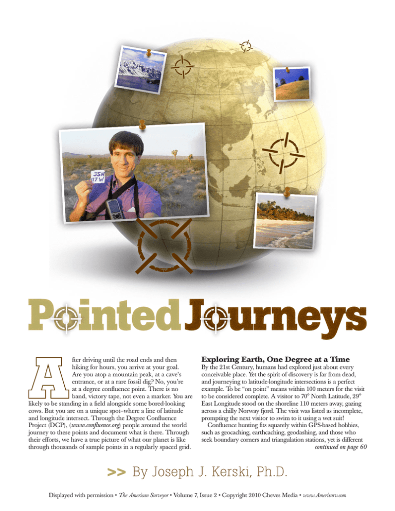
Pointed Journeys fter driving until the road ends and then hiking for hours, you arrive at your goal. Are you atop a mountain peak, at a cave’s entrance, or at a rare fossil dig? No, you’re at a degree confluence point. There is no band, victory tape, not even a marker. You are likely to be standing in a field alongside some bored-looking cows. But you are on a unique spot–where a line of latitude and longitude intersect. Through the Degree Confluence Project (DCP), (www.confluence.org) people around the world journey to these points and document what is there. Through their efforts, we have a true picture of what our planet is like through thousands of sample points in a regularly spaced grid. Exploring Earth, One Degree at a Time By the 21st Century, humans had explored just about every conceivable place. Yet the spirit of discovery is far from dead, and journeying to latitude-longitude intersections is a perfect example. To be “on point” means within 100 meters for the visit to be considered complete. A visitor to 70° North Latitude, 29° East Longitude stood on the shoreline 110 meters away, gazing across a chilly Norway fjord. The visit was listed as incomplete, prompting the next visitor to swim to it using a wet suit! Confluence hunting fits squarely within GPS-based hobbies, such as geocaching, earthcaching, geodashing, and those who seek boundary corners and triangulation stations, yet is different continued on page 60 >> By Joseph J. Kerski, Ph.D. Displayed with permission • The American Surveyor • Volume 7, Issue 2 • Copyright 2010 Cheves Media • www.Amerisurv.com 35° North 117° West 36º North 116º West on the GPS equal zero may look strange to an observer. If the point is under heavy tree cover, near buildings, or in a canyon, the explorer may never achieve the moment of zero nirvana. Portrait of the Planet Above left is at 35 N 117 W in the Mojave Desert (the author is shown on the preceding page at the 35 N 117 W confluence). Above right is at 36 N 116 W on the California-Nevada border. Kerski, continued from page 64 from all of them. First, the points are fewer in number, and many are difficult to reach, are dangerous, or are on restricted lands. While geocaching.com listed 260,000 visits by nearly 40,000 visitors in one week in December 2007, over the past 15 years, 11,000 visitors have journeyed to about 6,000 confluence points. Second, confluence hunting is primarily a scientific, not a recreational, endeavor. In 1996, 21-year-old computer programmer and entrepreneur Alex Jarrett passed near 43°00'00" North 72°00'00" West on his daily commute in New Hampshire. Wondering what would be at that spot, he and a friend journeyed there on bicycles with Alex’s new GPS receiver, and posted their photos to Alex’s new website. Others began visiting points near where they lived, and the website soon had to be moved to a larger server with full database capabilities. Regional coordinators were recruited and the project became a perfect example of neogeography, or volunteered geographic information. GPS, a paper map, and standard survival gear. Colin Irvine and Ken Long visited 18 North 46 East, describing the Empty Quarter of the Rub`al-Khāliy in Saudi Arabia as “a nice neighborhood which has no rush hour traffic and one of the lowest crime rates on the planet.” Besides the GPS, the 75 kg of ice that they had purchased certainly helped. The Confluence Dance Given the movement of the earth and the GPS satellites, along with the GPS inaccuracies, stepping left, right, forwards, and backwards in order to capture the moment when all the decimals People have walked, skied, hiked, sailed, kayaked, motorboated, tugboated, freighted, and even submarined to reach these points. They have used ultralight aircraft, helicopters, snowmobiles, trucks, cars, buses, taxis, bicycles, rickshaws, all-terrain vehicles, icebreakers, dogsleds, and motorcycles. The highest point is considered to be 30° North 81° East in Nepal, near India and China, at 5,845 meters (19,177 feet), attempted by Greg Michaels and Mitch Dion in 2008. After weeks of preparation and alpine hiking to within 37 km of the confluence, government officials forced them to turn back, and they even had to escape a drunk doctor on the way down! However, Greg Michaels and Robert Whitfield successfully visited the second highest confluence, at 33° North 80° East in Tibet, in 2005, costing them 11 days and very nearly their lives. The planet’s lowest, at 78 meters below sea level lies at 30° North 27° East in Egypt, is far Seeking and Finding There are 64,442 latitude and longitude degree intersections in the world, with 14,029 on land. Just over 2,000 are in water within sight of a shoreline, with 151 on an ice cap. By 2009, there were still over 10,000 yet to be found. Your nearest confluence is closer than 49 miles (79 km) away. If you feel inclined to visit one, secure permission if you will be accessing private land, bring batteries, a 9.0 miles (14.5 km) north of Crested Butte, Colorado. Displayed with permission • The American Surveyor • Volume 7, Issue 2 • Copyright 2010 Cheves Media • www.Amerisurv.com easier to visit. The highest confluence point in the USA lies near the summit of Mount Wrangell, Alaska. I have attempted perhaps the world’s steepest confluence point, at the rim of the Grand Canyon at 36° North 112° West. A national park ranger is, appropriately, the only successful visitor thus far. The trek that Dr. Shannon White and I made to 41° North 112° West into the Great Salt Lake was certainly my wettest point. But Matt Taylor had us beat, stepping through a chest-deep lake in Alaska to reach 62° North 150° West. On the other end of the scale, a visit to the driest place on Earth at 19° South 70° West revealed surprising sculptures. A volcanic view makes 8° South 113° East in Indonesia one of the most beautiful, along with the view down Kjerkefjord in Norway at 68° North 13° East. The most beautiful I have visited may be 39° North 107° West in Colorado or the yellow field of canola at 52° North 0° in England. The levee behind an industrial park at 30° North 90° West in New Orleans may have been my “creepiest” point. The loudest might be 40° North 83° West near Ohio State University! And during 2006, while wandering a new subdivision in Virginia, I found that $699,900 could have bought 38° North 79° West. While human impact is evident at thousands of points, we haven’t yet paved over all of Planet Earth. Remote points still exist, such as 21° South 26° East on Sua Pan in Botswana. The visitors reached it by quad bike after their vehicle became stuck. My own Dr. Kerski at 1.5 miles (2.4 km) WNW of Bridgewater, Massachusetts. loneliest was 33° North 97° West in a halfabandoned industrial park in Dallas. The most hazardous was my guard-escorted trek to a power plant outside of Mobile. I declined to wade into the asbestos dump for the final 200 meters. Following the North and South Poles, 0° 0° is probably the most famous. The crew of the US Coast Guard Cutter Sherman passed within 1,014 meters The Most Dangerous Points Lawrence and Seng left an Internet conference for a nighttime tromp to 4° North 102° East in Malaysia. They encountered a swamp, leeches, thistles, heat, exhaustion, and border guards, and lost their glasses and a leather business card holder. Rainer Mautz was escorted by police to 14° North 44° East in Yemen. A military escort accompanied “Doing the Confluence Dance to capture the moment when all the decimals on the GPS equal zero may look strange to an observer.” of this spot in 2001, jumping into the Atlantic Ocean to celebrate! In 2007, I journeyed 1,100 miles along 38 and 40 North Latitude to visit seven confluences in Kansas and Colorado in one day. Rainer Mautz and Elionora visited 10 confluences in Europe in one day, matched by David Coombs who stated that the lack of speed limit on many German highways helped. Murray and Christine Grainger were the first to log visits to the opposite sides of the world, in Spain and in New Zealand, choosing the date 03-03-03 to finish off the pair at 37 North 5 West, and 37 South 175 East, just to “make it a little more special.” me to 34° North 78° West on a base in North Carolina. The group motoring in a Land Cruiser across the Sahara Desert in Algeria toward the border with Niger after finding 23° North 10° East was stopped by a group of armed men. Fortunately, the armed men gave them bread, cookies, and yogurt. Greg Michaels’ quest for the last four points in Bosnia and Herzegovina was riddled with land mines. A black mamba snake came centimeters from killing one of the 7° North 2° West explorers in Ghana. But the group trudged onward to 6° North 3° West, to be assaulted by a swarm of army ants. Polar bears were seen by those Displayed with permission • The American Surveyor • Volume 7, Issue 2 • Copyright 2010 Cheves Media • www.Amerisurv.com traveling to Svalbard, Norway, while Magne Svensen walked to 4° South 36° East amongst carnivorous animals in the Tarangire National Park, Tanzania. Peter Mosselberger found an idol fence at 5° North 7° East in Nigeria which read, “If you enter this territory On a hike en route to 38 North 105 West. without properly sacrificing an animal, you’ll be afflicted with an incurable sickness.” Peter declined to enter. Leave No Trace Even though the project adheres to the “leave no trace” creed, governments, companies, or civic groups have established some permanent markers. 50° North 6° East in Luxembourg is marked by a steel pole, 35° North 135° East is marked as the “navel of Japan,” and a wooden sign lies at Wisconsin’s 45° North 90° West. These permanent markers may have been surveyed using different datums and may not be on the true point. But I found that William Clark’s mark in 1806 on Pompey’s Pillar in Montana is amazingly close to 46° North 108° West! My 200 point visits brought me to out-of-theway places and allowed me to meet and travel with wonderful people. I have traversed grasslands with the Rosebud Sioux Tribe’s Land Officer, trekked through the Michigan woods 5.3 miles (8.5 km) WSW of Meeker, Colorado. with a funky dune buggy driver, and hiked through the Colorado forest with a Backpacker magazine reporter. I have walked along the Prime Meridian with a geography professor, crawled through Texas thorns with a GIS analyst, and walked the Santa Fe Trail with a park ranger. I have shadowed the footsteps of Lewis and Clark with a USGS cartographer, conversed with local farm animals with a Missouri Botanical Garden educator, and motor boated on the Gulf of Mexico with a university biologist. And I treasure the local folks: Joking elderly gentlemen in Alabama, the odd character living in a combination curio shop and junkyard in Texas, fishermen who took us into the English Channel, New Zealand dairy farmers, and OSU students playing in their kiddie pool. The project offers means of examining location, place, human-environmental interaction, movement, and regions-the five themes of geography. How have humans modified the land? What water exists, and what forces act to change the area? You may be surprised to find rocky cliffs in Saudi Arabia, USA rainforests, and Russian cactus. The project shows what places are really like, not what the tourist brochures show. The project also provides a research tool for verifying land cover data. Wander on the website along a latitude or longitude line to observe changes in vegetation, landforms, and time, such as after a wildfire in Russia and Las Vegas urbanization. From Iran to Mexico, people have opened their homes to the explorers. A confluence is a “flowing together;” the project is a meeting of the global community, to encourage stewardship for the land and respect for its people. To touch these points is to connect to the International Meridian Conference in 1884. Humans are explorers. They want to explore with a goal, even if that goal is to visit an arbitrary point defined by lines set down by people long since departed. Even if the final point is never reached, the project has created a global database that provides a portrait of our planet like no other. Joseph Kerski worked as a geographer for both the USGS as geographer (for 17 years) and the US Census Bureau (for 4 years). He currently serves on the ESRI Education Team and teaches part time at the University of Denver. For more information, visit www.josephkerski.com. Displayed with permission • The American Surveyor • Volume 7, Issue 2 • Copyright 2010 Cheves Media • www.Amerisurv.com
