Climate Change & Pacific Island Water Resources Problem Statement
advertisement

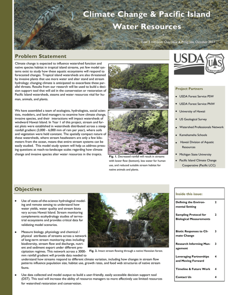
Climate Change & Pacific Island Water Resources Year 2 Initiative Overview & Progress, October 2011 Problem Statement Climate change is expected to influence watershed function and native species habitat in tropical island streams, yet few model systems exist to study how these aquatic ecosystems will respond to forecasted changes. Tropical island watersheds are also threatened by invasive plants that use more water and alter stand and stream hydrology; changing climate is anticipated to exacerbate these parallel threats. Results from our research will be used to build a decision support tool that will aid in the conservation or restoration of Pacific Island watersheds, steams and water resources vital for human, animals, and plants. Project Partners USDA Forest Service36: USDA Forest Service PNW We have assembled a team of ecologists, hydrologists, social scientists, modelers, and land managers to examine how climate change, invasive species, and their interactions will impact watersheds of windward Hawaii Island. In Year 1 of this project, stream and forest plots were established in watersheds distributed across a steep rainfall gradient (3,000 - 6,000 mm of rain per year), where soils and vegetation were held constant. The spatially compact nature of these watersheds, where stream headwaters are only a few kilometers from the ocean, means that entire stream systems can be easily studied. This model study system will help us address pressing questions at reach-to-landscape scales regarding how climate change and invasive species alter water resources in the tropics. University of Hawaii US Geological Survey Watershed Professionals Network Kamehameha Schools Hawaii Division of Aquatic Resources Fig. 1. Decreased rainfall will result in streams with lower flow (bottom), less water for human use, and reduced suitable stream habitat for native animals and plants. Objectives Use of state-of-the-science hydrological modeling and remote sensing to understand how water yields, water quality and stream biota vary across Hawaii Island. Stream monitoring complements ecohydrology studies of terrestrial ecosystems and provides critical data for validating model scenarios. Measure biology, physiology and chemical / physical attributes of streams across a network of long-term stream monitoring sites including: biodiversity, stream flow and discharge, nutrient and sediment export under different precipitation regimes. This network across a 3000- Fig. 2. Intact stream flowing through a native Hawaiian forest. mm rainfall gradient will provide data needed to understand how streams respond to different climate variation, including how changes in stream flow patterns influence population size, habitat use, growth rates, and food web structures of native stream fauna. Use data collected and model output to build a user-friendly, easily accessible decision support tool (DST). This tool will increase the ability of resource managers to more effectively use limited resources for watershed restoration and conservation. Michigan State University Pacific Island Climate Change Cooperative (Pacific LCC) Inside this issue: Defining the Environmental Setting 2 Sampling Protocol for Biological Measurements 2 Biotic Responses to Climate Change 3 Research Informing Management 3 Leveraging Partnerships and Moving Forward 4 Timeline & Future Work 4 Contact Us 4 Climate Change & Pacific Island Page 2 The Environmental Setting Permanent monitoring stations have been established in 9 streams along the North Hilo and Hamakua districts of Hawaii Island. The streams are within watersheds that span a steep precipitation gradient (~3000 mm of annual rainfall on the dry end of the gradient to >6000 mm on the wet end ). Stream sites are located between 450-550 m in elevation and drain younger lava flows (11,000-64,000 years old) dominated by ohia (Meterosideros polymorphia) forests. Stream discharge and channel morphology data collected from these sites will be used to expand forecasting with the Distributed Hydrology, Soil, and Vegetation Model (DHSVM) that was parameterized in 2010. Various climate change and invasive species scenarios will be run to determine their independent and interactive impacts on water quantity and quality, as well as stream habitat suitability. Working with multiple partners allows us to pool knowledge, tools, and models for more effective evaluation of potential watershed restoration actions. Fig 3. Project area map of the environmental setting, including mean annual precipitation isohyets (yellow lines), geologic age of substrate and the location of study sites (green dots) with active stream gages. Sampling Protocol for Biological Measurements Nutrient concentrations, stable water isotopes, and various ecological parameters from study streams are being compared across our rainfall gradient to determine how changes in stream flow alters water quantity, habitat suitability and ecological function of tropical streams. These same parameters are also being measured over time in order to detect any influences of inter-annual variation in rainfall, with the goal of comparing responses to short-term changes in annual rainfall to long-term changes observed across our gradient. Fig. 4. Native shrimp (opae, Atyoida bisulcata) with an elastomer tag for identification. Ecological parameters include algal productivity, invertebrate community composition, shrimp body mass and reproductive success, food web structure and leaf litter decomposition. Working with the Pacific Island Climate Change Cooperative, we will use these parameters along with in-stream habitat measurements to develop vulnerability assessments of stream fauna to changes in stream flow. Year 2 Initiative Overview & Progress, October 2011 Page 3 Biotic Responses to Climate Change 12 Shrimp length (mm) A 10 8 6 4 Wetter Drier 2 Body condition index (x 105) Primary productivity and food web structure. We have begun studies to examine the influence of flow regimes, nutrient availability, and grazing patterns on stream primary productivity. Preliminary results suggest that decreased stream flow alters feeding behavior of native shrimp, potentially shifting from an autochthonous (internal carbon sources) to an allochthnous (external carbon sources) based food web. 2.8 2.6 2.4 2.2 2.0 B Native species responses. In addition to serving as a model organism in our field system, native freshwater shrimp (`opae) are important ecological and cultural components of Hawaiian streams. Little is known about „opae habitat preferences, reproductive success, or feeding behaviors. Preliminary results reveal that decreasing stream flow results in decreased shrimp body size (Fig. 5A) and condition (Fig. 5B). 1.8 Decomposition. Leaf litter decomposition provides e e a carbon and nutrients that support secondary production le le li'i a o o a o m p h h n e au i'o le K Pa Ho ho wa Um Ko Pa in streams and near shore ecosystems. Decomposition no Ma rates will likely be impacted by changes in stream flow, which is expected to alter nutrient cycling in streams, Fig. 5. A) Average (± SE) size class and B) body condition nutrient delivery to coastal areas, and secondary producof native shrimp sampled from streams across our precipition. We are initiating studies to understand how tation gradient on Hawaii Island. Body condition is the changes in stream flow will alter leaf litter decomposiratio of weight to length and is an overall measure of fittion. In addition to reduced water supply, decreased 1.6 ness. Higher values represent healthier organisms. stream flow will also have negative impacts on native stream organisms, ecosystem services vital to the people of Hawaii. Research Informing Management Through a new grant from the Pacific Islands Climate Change Cooperative, and working with PNW scientists, Keith Reynolds and Gordon Reeves, we are using output from the parameterized DHSVM model and data from our stream monitoring network to develop a decision support tool for tropical island watershed management. The Ecosystem Management Decision Support (EMDS) is a user-friendly, GIS-based platform that will be used to create the decision support tool for resource managers throughout Hawaii and the western Pacific. The output of the EMDS are maps (Fig. 6) that identify priority areas in need of some type of management action (e.g., reforestation, invasive species control). This will ultimately enable Pacific Island resource managers to more effectively utilize limited resources to develop and implement adaptation or restoration strategies for watershed conservation in the face of a changing climate and/or increased Fig. 6. Example output from a PNW EMDS. Blue areas represent areas of high aquatic impact and that require some spread of invasive species. management action (e.g., reforestation, limited timber harvest). Climate Change & Pacific Island Water Resources Leveraging Partnerships and Moving Forward Through the alliance of research and land management organizations, this initiative is yielding knowledge and tools needed to address climate change and invasive species impacts on stream biodiversity and watershed function throughout the Western Pacific region. This initiative has allowed the Pacific Southwest Research Station to partner with the Pacific Opae kala`ole (Atyoida bisulcata), a dominant stream organism, filtering food particles out of the water column. This research initiative is providing an integrated understanding of watershed function that is vital to increasing the resilience of tropical watersheds to climate change while informing managers on restoration actions required to sustain ecosystem goods and services. For Further Information, Contact: Richard MacKenzie Research Scientist 60 Nowelo Street Hilo, HI 96720 (808) 854—2616 rmackenzie@fs.fed.us Northwest Research Station, the Rocky Mountain Research Station and the International Institute of Tropical Forestry on national level climate change and freshwater research. This research framework was critical for supporting new projects funded by the Pacific Island Climate Change Cooperative, and the Hawaii Fish Habitat Partnership, as well as future proposals to NSF Water Sustainability and Climate Program and USGS Pacific Island Climate Science Center. This partnership-based initiative is informed by and will deliver research products directly to land managers so outcomes are rapid and relevant to society. Timeline & Future Work 2010: (i) parameterized and calibrated DHSVM with Hawaiian-specific data, (ii) identified long-term study reaches in 9 streams, (iii) sampled nutrients and invertebrates from these streams. 2011: (i) established study sites in 9 streams, (ii) installed flow gages and began to develop rating curves, (iii) sampled streams for nutrients, stable isotopes, and habitat, (iv) quantified relationships between stream flow, shrimp growth, and algal productivity, (v) forecast impacts of climate change and invasive species on stream flow and water quality, (vi) initiated long-term leaf litter decomposition and food-web structure studies. Fig 6. Local high school students present their mural, “Conservation of Native Hawaiian Streams” to the “Forest, Ocean, Climate and Us” Program (FOCUS). Their mural was based upon visits to project sites with 2012: (i) sample streams for nutrients, Forest Service scientists, where they learned about native stream animals, stable isotopes, algae, invertebrates, stream habitat, and the threats of invasive plants species and climate change. fish, and leaves, (ii) examine response of stream variables (flow, nutrients, biotic variables) to spatial variation in climate (precipitation and temperature) and compare to model outputs; (iii) adapt and validate stream-focused decision support tools for Hawaiian streams; (iv) model how changes in stream flow alter native shrimp production, reproduction, and recruitment, (v) install plots in native and exotic dominated forests along precipitation gradient. 2013: (i) sample streams for nutrients, stable isotopes, algae, invertebrates, fish, and leaves, (ii) begin larger -scale extension of NETMAP-type EMDS for water resource managers on other Pacific Islands. (iii) quantify how invasion of native forests by exotic species alters hydrological and sediment inputs and compare with model outputs. 2014: (i) sample streams for nutrients, stable isotopes, algae, invertebrates, fish, and leaves, (ii) examine response of stream variables (flow, nutrients, biotic variables) to inter-annual variations in climate; (iii) compare findings to model outputs. The U.S. Department of Agriculture (USDA) prohibits discrimination in all its programs and activities on the basis of race, color, national origin, age, disability, and where applicable, sex, marital status, familial status, parental status, religion, sexual orientation, genetic information, political beliefs, reprisal, or because all or part of an individual’s income is derived from any public assistance program. (Not all prohibited bases apply to all programs.) Persons with disabilities who require alternative means for communication of program information (Braille, large print, audiotape, etc.) should contact USDA’s TARGET Center at (202) 720-2600 (voice and TDD). To file a complaint of discrimination, write USDA, Director, Office of Civil Rights, 1400 Independence Avenue, SW, Washington, DC 20250-9410 or call (800) 795-3272 (voice) or (202) 720-6382 (TDD). USDA is an equal opportunity provider and employer.


