File
advertisement
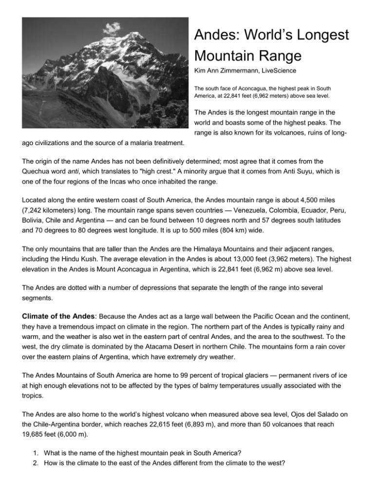
Andes: World’s Longest Mountain Range Kim Ann Zimmermann, LiveScience The south face of Aconcagua, the highest peak in South America, at 22,841 feet (6,962 meters) above sea level. The Andes is the longest mountain range in the world and boasts some of the highest peaks. The range is also known for its volcanoes, ruins of longago civilizations and the source of a malaria treatment. The origin of the name Andes has not been definitively determined; most agree that it comes from the Quechua word anti, which translates to "high crest." A minority argue that it comes from Anti Suyu, which is one of the four regions of the Incas who once inhabited the range. Located along the entire western coast of South America, the Andes mountain range is about 4,500 miles (7,242 kilometers) long. The mountain range spans seven countries — Venezuela, Colombia, Ecuador, Peru, Bolivia, Chile and Argentina — and can be found between 10 degrees north and 57 degrees south latitudes and 70 degrees to 80 degrees west longitude. It is up to 500 miles (804 km) wide. The only mountains that are taller than the Andes are the Himalaya Mountains and their adjacent ranges, including the Hindu Kush. The average elevation in the Andes is about 13,000 feet (3,962 meters). The highest elevation in the Andes is Mount Aconcagua in Argentina, which is 22,841 feet (6,962 m) above sea level. The Andes are dotted with a number of depressions that separate the length of the range into several segments. Climate of the Andes: Because the Andes act as a large wall between the Pacific Ocean and the continent, they have a tremendous impact on climate in the region. The northern part of the Andes is typically rainy and warm, and the weather is also wet in the eastern part of central Andes, and the area to the southwest. To the west, the dry climate is dominated by the Atacama Desert in northern Chile. The mountains form a rain cover over the eastern plains of Argentina, which have extremely dry weather. The Andes Mountains of South America are home to 99 percent of tropical glaciers — permanent rivers of ice at high enough elevations not to be affected by the types of balmy temperatures usually associated with the tropics. The Andes are also home to the world’s highest volcano when measured above sea level, Ojos del Salado on the Chile-Argentina border, which reaches 22,615 feet (6,893 m), and more than 50 volcanoes that reach 19,685 feet (6,000 m). 1. What is the name of the highest mountain peak in South America? 2. How is the climate to the east of the Andes different from the climate to the west? The Eight Most Important Things to Know About the Amazon River By Matt Rosenberg The Rio Negro tributary of the Amazon River in Brazil. Jose de Paula Machado/Getty Images The Amazon River in South America is an amazing and important river for the planet and therefore, you need to know about it. Here are the eight most important things you need to know about the Amazon River: 1. The Amazon River carries more water than any other river in the world. In fact, the Amazon River is responsible for about one-fifth (twenty percent) of the fresh water that flows into the world's oceans. 2. The Amazon River is the second longest river in the world (the Nile River in Africa is the longest) and is about 4,000 miles (6400 km) long. (In July 2007 a group of scientists reportedly determined that the Amazon River might just be the longest river in the world, taking that title from the Nile River. It will take further studies to substantiate the claim and for the Amazon River to be recognized as the longest.) 3. The Amazon River has the largest watershed (area of land that flows into the river) and more tributaries (streams that flow into it) than any other river in the world. The Amazon River has more than 200 tributaries. 4. Streams that begin in the Andes Mountains are the starting sources for the Amazon River. 5. Most of the runoff of Brazil flows into the Amazon River along with runoff from four other countries: Peru, Bolivia, Colombia, and Ecuador. 6. Due to the vast amount of water as well as sediment that are deposited where the Amazon River meets the Atlantic Ocean, the color and salinity of the Atlantic Ocean are modified for nearly 200 miles (320 km) from the delta. 7. For much of its path, the Amazon River can be as much as one to six miles wide! During flood seasons, the Amazon River can be much, much wider; some report it is more than 20 miles wide (32 km) in certain places. 8. The Amazon River taken different routes since it began to carry water. Some scientists have determined that the Amazon River even flowed west at one time or more, into the Pacific Ocean. 1. Where does the Amazon River originate? Where does the River end? 2. How does the Amazon River affect the color and salinity of the Atlantic Ocean? Driest Place: Atacama Desert, Chile Even the Driest Place on Earth has Water Dry mountains in the Atacama Desert see an average of less than .004 inches/.01cm of rain per year. Many times this area will go without rainfall at all for years. Some places in the Atacama Desert have not had rainfall for over 400 years. The Atacama desert is found along the coast of Chile, South America – right next to the Pacific Ocean – the biggest body of water in the world. Much of the desert extends up into the Andes mountains and is very high in elevation. Unlike more familiar deserts, like the Sahara desert in Africa and the Mojave in California, the Atacama is actually a pretty cold place, with average daily temperatures ranging between 32 and 80°F. The annual rainfall (or lack of it) defines a desert, but that doesn’t mean that it never rains in Atacama. Every so often a warming effect over the Pacific Ocean around the equator changes the weather the world over and even places like the driest desert in the world can become doused with drenching storms. Even though Atacama gets almost no rainfall, there is water in this arid place and you’ll find it in the following places: Salt Lakes: During years of heavy rainfall in the distant past, enough water accumulated in basins found throughout the Andes to create lakes. Some of the lakes got their water from melting glaciers at the end of the last ice age. But in some lakes in the Andes mountains, such as Atacama, more water is lost through evaporation than is replaced by rainfall so the lakes are drying up. As the water evaporates, the mineral salts in the water become more concentrated, creating very salty water. Snow: In the higher elevations when precipitation comes to Atacama snow falls instead of rain. There are small patches of unmelted snow in the mountain tops where it never gets warm enough to melt the snow. Underground: Anywhere you go in the world, regardless of how much or little it rains, there is always water underground. After it rains, some of the rainwater evaporates back into the air, but much of it trickles down into the ground and stays there – even in the desert. How much water and where depends on a number of things; soil composition, air and soil surface temperature, amount and frequency of rainfall/precipitation, and drainage. Since the Andes is a volcanically active mountain range, the magma beneath the ground will heat the groundwater in certain places causing geysers to erupt. Fog and Dew: Most of the precipitation that comes to the Atacama is in the form of fog that blows in from the Pacific. Fog is essentially very low clouds, consisting of water vapor cooling and beginning to condense. If you’ve ever been in fog you know that it can leave you a little moist. When the air temperature reaches dew point the water vapor in the air condenses to leave little droplets of water behind. The few things that are able to survive in the Atacama live on the combined moisture from fog and dew. 1. How is the Atacama different from other deserts like the Mojave and Sahara? 2. Oh no! You just got stranded in the Atacama Desert. How would you get drinking water? Driest Place: Atacama Desert, Chile The Atacama Desert is the driest hot desert on the planet, but does anything live there? Does Anything Live There? Many people have the view that deserts are places forsaken by Mother Nature and that no living thing would possibly want to set up camp in a place so dry. Although it is tough to find anything living in the Atacama there are isolated pockets and small patches of plants, which support life for animals and insects. Some plant species have adapted well to this dry environment by developing tap roots that run very deep into the ground gathering water from below. There are flocks of flamingos that live in and around the salt lakes feeding on red algae that grows in the waters. There are even people living in the Atacama. There is a town called Calama in the desert which is complete with motels, restaurants and shops, but it is definitely not the norm. For the most part, Atacama is a pretty lonely place. Humans have lived in the Atacama for many thousands of years, based on the cultural relics and artifacts that archaeologists have found. The South American Indians who have set up housekeeping in the desert over the millennia have left relics from their culture and even themselves. Because the Atacama is so bonedry, the bodies of the buried indians have dried perfectly preserved turning them into mummies. Some of the oldest mummies found anywhere on earth have come from the Atacama Desert and have been dated to be 9,000 years old! What Causes Deserts? One reason is that the high atmospheric pressure in this region over the Andes can cause dry, cold air from the upper altitudes to compress and come down to earth. This dry air has almost no water vapor so it can be easily heated by the sun, causing high ground temperatures with very low humidity. Another reason that the Atacama doesn't get enough rainfall is because of a phenomenon called rainshadow. The warm, moist tropical air that blows on the tradewinds from the east, which douse the South American rainforest, get hung-up on the east side of the Andes. The mountains are so high in altitude that the air cools, condenses and rains (or snows) on the mountains. As the air descends the other side of the mountain range it warms, holding in its moisture preventing rain from falling on to the ground below. This is one of the reasons why the Amazon basin and river are the largest anywhere in the world. The mountains that cause the Amazon to be the largest river from collecting all the rainfall are also responsible for preventing the Atacama from ever receiving any rainfall. The driest and one of the wettest places in the world are right next to each other! 1. What types of life are found in the Atacama Desert? 2. Why does the Atacama not get enough rainfall? The Amazon Rainforest: The World’s Lungs The Amazon rainforest, also known as Amazonia, is one of the world’s greatest natural resources. Because its vegetation continuously recycles carbon dioxide into oxygen, it has been described as the “Lungs of our Planet”. About 20% of earth’s oxygen is produced by the Amazon rainforest. The Amazon rainforest gets its name from the Amazon River, the life force of the rainforest. The Amazon River begins in the Peruvian Andes, and winds its way east over the northern half of South America. It meets the Atlantic Ocean at Belem, Brazil. The main river is about 4,080 miles long. Its drainage basin covers 2,722,000 million square miles, and lies in the countries of Brazil, Columbia, Peru, Venezuela, Ecuador, Bolivia, and the three Guyanas. Sixteen percent of all the world’s river water flows through the Amazon delta. Twenty eight billion gallons of water flow into the Atlantic every minute, diluting the salinity of the ocean for more than 100 miles offshore. The Amazon rainforest watershed is home to the world’s highest level of biodiversity. Amazonia receives about 9 feet of rain every year. Fifty percent of this returns to the atmosphere through the foliage of trees. Most of the Amazon River’s water comes from the annual snowmelt high in the Peruvian Andes. Between June and October, the water level rises by 30 to 45 feet. Tens of millions of acres of rainforest are covered by water as the flood advances, reaching as far inland from the main channel as 12 miles. Some 15 million years ago, the Amazon River flowed westward into the Pacific Ocean. When the South American plate moved into another tectonic plate, the Andes Mountains slowly rose up and blocked the flow of the river. As the river system backed up, freshwater lakes were formed, and the environment of the Amazon basin changed drastically. Then about 10 million years ago the river found its way eastward towards the Atlantic. Today, more than 20% of the Amazon rainforest has been destroyed and is gone forever. The land is being cleared for cattle ranches, mining operations, logging, and subsistence agriculture. Some forests are being burned to make charcoal to power industrial plants. More than half of the world’s rainforests have been destroyed by fire and logging in the last 50 years. Over 200,000 acres are burned every day around the world, or over 150 acres every minute. Experts also estimate that 130 species of plants, animals, and insects are lost every day. At the current rate of destruction, it is estimated that the last remaining rainforests could be destroyed in less than 40 years. Native peoples of the Amazon rainforest have used different plants for centuries as cures and potions for their health and survival. Scientists are now discovering that many of the plants are sources for new drugs for AIDS, cancer, diabetes, arthritis, and Alzheimer’s. Quinine, muscle relaxants, steroids, and caner drugs have already been discovered. Today 121 prescription drugs sold around the world come from plant-derived sources. Although 25% of all drugs are derived from rainforest ingredients, scientists have tested only 1% of tropical plants. Another concern for Amazonia is the fate of it indigenous people. An estimated 10 million Indians were living in Amazonia about five hundred years ago. Today there are less than 200,000 indigenous peoples left in Amazonia. remaining are 70 years old or more. With them goes a wealth of knowledge of medicinal species of plants and organisms. 1. What caused the Amazon River to begin flowing east towards the Atlantic instead of west towards the Pacific? 2. Why is the rainforest being cleared? The Pampas: South America’s Grassland The Pampas of South America are a grassland biome. They are flat, fertile plains that covers an area of 300,000 sq. miles or 777,000 square kilometers, from the Atlantic Ocean to the Andes Mountains. It is found primarily in Argentina and extends into Uruguay. The word Pampas comes from the Guarani Indian word for level plain. The Argentinean Pampas are the home of the 'Gaucho', the original South American cowboy. The pampas is located just below Buenos Aires, between 34° and 30° south latitude, and 57° and 63° west latitude. The average temperature in the Pampas is 64° F. The pampas has a 'high sun' or dry season in the summer, which in the Southern Hemisphere is in December. The wind blows most of the time. The climate in the pampas is humid and warm. Several interesting mammals can be found in the pampas. The Geoffroy's Cat, for example, with its gray coat and black stripped legs, is almost invisible in the mesquite and bunchgrass. The Maned Wolf has very long legs so it can see over the tall grasses. Also, one can find a llama-like Guanaco that lingers among the ponds. It is important to note that at least fifteen mammal species, twenty bird species, and fifteen plant species are at serious risk of extinction in the Pampas. The humid Pampas ecosystem is one of the richest grazing areas in the world. Because of its temperate climate and rich, deep soil, most of the Pampas has been cultivated and turned into croplands. Unfortunately, domestic livestock and farming have severely affected the pampas. Fertilizers and overgrazing are a serious threat to the pampas. There are only a very few pristine remnants of the legendary "ocean of grass" that was the Pampas. It is considered to be one of the most endangered habitats on earth. by Claire L. 2002, http://www.blueplanetbiomes.org/pampas.htm 1. In what ways has the wildlife of the pampas evolved to survive in their environment? 2. What are the threats to the pampas today?
