Bow Echoes : Conceptual Schemes and European Relevance
advertisement
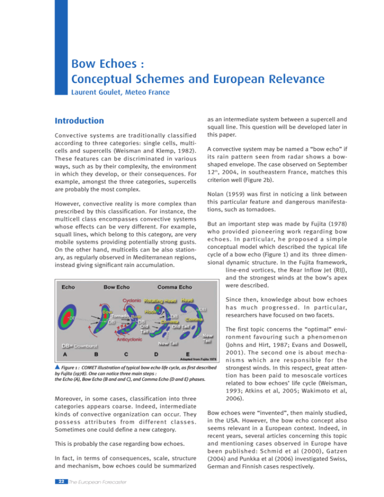
Bow Echoes : Conceptual Schemes and European Relevance Laurent Goulet, Meteo France Introduction Convective systems are traditionally classified according to three categories: single cells, multicells and supercells (Weisman and Klemp, 1982). These features can be discriminated in various ways, such as by their complexity, the environment in which they develop, or their consequences. For example, amongst the three categories, supercells are probably the most complex. However, convective reality is more complex than prescribed by this classification. For instance, the multicell class encompasses convective systems whose effects can be very different. For example, squall lines, which belong to this category, are very mobile systems providing potentially strong gusts. On the other hand, multicells can be also stationary, as regularly observed in Mediterranean regions, instead giving significant rain accumulation. as an intermediate system between a supercell and squall line. This question will be developed later in this paper. A convective system may be named a “bow echo” if its rain pattern seen from radar shows a bowshaped envelope. The case observed on September 12th, 2004, in southeastern France, matches this criterion well (Figure 2b). Nolan (1959) was first in noticing a link between this particular feature and dangerous manifestations, such as tornadoes. But an important step was made by Fujita (1978) who provided pioneering work regarding bow echoes. In particular, he proposed a simple conceptual model which described the typical life cycle of a bow echo (Figure 1) and its three dimensional dynamic structure. In the Fujita framework, line-end vortices, the Rear Inflow Jet (RIJ), and the strongest winds at the bow’s apex were described. Since then, knowledge about bow echoes has much progressed. In particular, researchers have focused on two facets. Figure 1 : COMET illustration of typical bow echo life cycle, as first described by Fujita (1978). One can notice three main steps : the Echo (A), Bow Echo (B and and C), and Comma Echo (D and E) phases. Moreover, in some cases, classification into three categories appears coarse. Indeed, intermediate kinds of convective organization can occur. They possess attributes from different classes. Sometimes one could define a new category. This is probably the case regarding bow echoes. In fact, in terms of consequences, scale, structure and mechanism, bow echoes could be summarized 22 The European Forecaster The first topic concerns the “optimal” environment favouring such a phenomenon (Johns and Hirt, 1987; Evans and Doswell, 2001). The second one is about mechanisms which are responsible for the strongest winds. In this respect, great attention has been paid to mesoscale vortices related to bow echoes’ life cycle (Weisman, 1993; Atkins et al, 2005; Wakimoto et al, 2006). Bow echoes were “invented”, then mainly studied, in the USA. However, the bow echo concept also seems relevant in a European context. Indeed, in recent years, several articles concerning this topic and mentioning cases observed in Europe have been published: Schmid et al (2000), Gatzen (2004) and Punkka et al (2006) investigated Swiss, German and Finnish cases respectively. The goals of this paper are multiple. First of all, our purpose is to provide the main structural and temporal characteristics of bow echoes: spatial organization, typical life cycle, internal dynamics, consequences in terms of hazards, and their various footprints in observations. Secondly, we focus our attention on the mechanisms responsible for this unique kind of convection. In particular, we place emphasis on building mesovortices, RIJ dynamics, and the “RKW” (Rotunno, Klemp and Weisman, 1988) paradigm, in which an equilibrium has to exist between baroclinic vorticity (associated to density current), and environmental vorticity (related to vertical wind shear). Moreover, we give some insights about environmental conditions favouring such a convective organization. A short review will be proposed. To conclude this article, we outline some checks linked to bow echoes observational footprints, giving some precious information about the convective system. Also, some perspectives will be provided regarding forecast and monitoring. Typical Life Cycle and Key Features A bow echo is at first characterized by a bowshaped pattern as observed by a radar network (Figures 2b and 3). Its size is of the order of tens to 150 km (compared to 100 to 1000 km for a squall line). Its lifetime varies from tens of minutes to several hours. Before the development of the ‘bow’, the convective context is very varied. Convection can be very organized such as in supercells or squall lines (Figure 2a), respectively in 15 and 40% of cases (Klimowski et al, 2004). But in a slight majority of cases (45%), convection appears only weakly organized. Figure 2 : Radar reflectivities from the French radar network ARAMIS, at 2245 utc (a), 0015 utc (b), 0100 utc (c). This sequence shows typical life cycle of a bow echo from a linear squall line (a) to a comma shape echo (c). The bow echo phase seems to be consecutive to merging of the squall line with the “convective system number 2”, off the Pyrénées Orientales. Typically, bow echo formation starts from a cluster of more or less independent cells. Then these merge, leading to a flat system (Figure 1, step “A”). Afterwards, the reflectivity pattern starts to bow. Concavity rapidly amplifies (Figure 1 – phases B and C, Figure 2b). In some cases, reflectivities show a spearhead shaped pattern (Figure 3). This evolution is related to a strong acceleration of midlevel flow at the rear of the convective system: the so called Rear Inflow Jet (RIJ; Fujita, 1978). The Rear Inflow Jet is focused around the centre of the line, helping its deformation and subsequent bow pattern evolution. The RIJ is an important facet of a bow echo. It is at the heart of its dynamics. As the RIJ goes down to the ground, it leads to strong acceleration of the surface wind with substantial straight-line damaging effects (sometimes from F0 to F1 level). One reliable radar signature of the RIJ is the Rear Inflow Notch (“RIN”), a channel of weak radar echo (Figure 3; Przybylinski, 1995). The European Forecaster 23 Rear Inflow Jet dynamic is partly connected to midlevel (from 3 to 7 km above ground level) lineend mesovortices: the bookend vortices. These can strengthen the RIJ, provided they are sufficiently close to each other. For a bow echo which is northsouth oriented, the northern and southern vortices are respectively cyclonic and anticyclonic. In the last part of the bow echo life cycle, the cyclonic vortex generally prevails. Convective organization then resembles a ‘comma’ pattern (Figure 1 – phases D and E, Figure 2c). In general, the size of vortices is of the order of tens of km. not negligible. The tornadoes are mainly F0 to F2. But stronger intensities (F3 to F4) have already been observed. Some studies suspect a link between midlevel vortices, in particular the northern cyclonic one, and tornado genesis (Funk et al, 1999). In this context, the influence of midlevel eddies may extend toward ground level. Many tornadoes seem also to be generated by low level meso-γ-scale vortices, in addition to midlevel ones. These typically form in the 0.3 km above ground level layer, along the leading edge of the convective system (Atkins et al, 2005). Such vortices whose size is of the order of several km are not systematically organized into couplets. They can appear solitary. It may be possible to discern between the tornadic and the non-tornadic vortices. Thus, tornadic vortices are stronger, longlived (duration longer than 1 hour) and deeper (Atkins et al, 2005). Low level vortices could also be implicated in straight line wind damage, in association with the RIJ, by modulation of pressure gradient (Wakimoto et al, 2006). The density current or cold pool is another important component of bow echoes. Several studies revealed that it is deeper than earlier thinking suggested; it typically approaches 3-5 km in depth, with thermal deficit from 6 to 8°C (Bryan et al, 2004). This is not surprising, as the cold Figure 3: (a) Typical horizontal pattern of a bow echo. One can notice : a) bookend pool plays a fundamental role regardvortices (“MV”) at the ends of the convective line ; b) the Rear Inflow Jet (green arrow), a ing gusts occurrence and more mid-tropospheric current coming from the rear of a bow echo ; c) low level meso vortex generally in the life cycle of the which are close to the convective system boundary ; d) the rear inflow notch, a channel of weak reflectivity in the the stratiform region ; e) the apex, the summit of the concave pattern. storm. Recently, Adams-Selin et al (b) Mediterranean case of the 17 august, 2004. Some key features have been reported. (2010 and 2013), have proposed mechanisms in which a cold pool Such mesovortices may strongly determine the contributes to bowing development by the intermedihydrometeors’ distribution, and therefore the reflec- ate mechanism of a so-called mesohigh surge. tivities. Thus a rolling up of high reflectivities may To conclude, bow echo structure is sometimes relareveal the existence of an eddy (Figure 2c). tively complex. One or several embedded bowing In the USA, around 20% of the total number of segments may develop inside a larger scale system, tornadoes may be induced by bow echoes and which can also be a bow echo or a squall line. squall lines (Tessendorf and Trapp, 2000). This is Bowing segments generally have their own bookend 24 The European Forecaster mesovortices, and their own RIJ, which represents typically a local strengthening of the system scale RIJ. (a) RIJ : the pressure gradient paradigm (from Lafore and Moncrieff, 1989) If a bow echo or larger scale system containing bow echo(es) is sufficiently intense, one can call it a derecho. Mechanisms a. The “RKW” Paradigm The cold pool is very prominent inside bow echoes. Its boundaries are a site of strong baroclinic horizontal vorticity. In the “RKW” theory (Rotunno, Klemp and Weisman, 1988), this baroclinic vorticity has to be more or less balanced by the environmental one (associated to wind shear). According to this condition, ascending motions are more upright and stronger. More severe and more durable storms are favoured. (b) RIJ : vorticity paradigm (from Weisman, 1993) b. Mesovortices Genesis One important bow echo attribute is its mesovortices. These have two types: 1) the midlevel bookend vortices, which appear at the ends of the convective line; 2) the low level vortices which develop along the leading edge of the storm system. Mechanisms proposed in various studies are generally based on the tilting of horizontal crosswise vorticity (Figure 4). Horizontal vorticity is most of the time baroclinically generated along the cold pool boundary. However, some of the genesis of the midlevel bookend vortices, could alternatively, at the beginning, be the result of environmental wind shear. Bookend vortices genesis : primary mechanism Figure 5: Complementary explanations of the Rear Inflow Jet. Lafore and Moncrieff (1989)’s explanation (a) is based on the xistence of a pressure gradient from front to rear of the convective system. Weisman (1993) propose an alternative mechanism, implying generated baroclinically vorticity, in relation to cold pool and the stratiform part (as associated latent heating). Concerning low level vortices, some uncertainties exist. Moreover, mechanisms have to be found for both solitary structures and couplet ones. Tilting of crosswise vorticity is not compatible with solitary vortices. Indeed, it necessarily generates couplets. Thus, tilting must imply streamwise vorticity, that is the component of the vorticity parallel to the storm relative flow. As vertical vorticity has been created, stretching by ascending motions amplifies the whirling motion. Moreover, stretching of the planetary vorticity (terrestrial rotation effect) explains why cyclonic circulations prevail finally, in particular in the northern bookend vortex (Weisman and Davis, 1998; Weisman and Trapp, 2003). c. Dynamics of the Rear Inflow Jet (RIJ) Figure 4: Main mechanism relative to bookend mesovortices genesis. This one is based on upward tilting of baroclinic horizontal vorticity. Baroclinic horizontal vorticity appears along boundaries of the density current. The RIJ is an important component of bow echoes. At first, it is partly responsible for the strongest winds, in particular as it is associated with low level meso-γ scale vortices (Wakimoto et al, 2006). Secondly, it is a very active piece in the complex puzzle of bow echo dynamics. The European Forecaster 25 The RIJ has received various explanations, which are generally complementary. Historically, Lafore and Moncrieff (1989) were the first to formulate an interpretation. According to the authors, the RIJ results from a midlevel pressure gradient between the rear and the front of the precipitating system stratiform part (Figure 5a). In particular, the RIJ develops from a midlevel meso low at the beginning of the stratiform part. Weisman (1993) offers an alternative explanation in terms of baroclinic vortices. As the stratiform part forms, the cold pool intensifies as it spatially extends. Thus a baroclinically generated vortices couplet is set up at the rear of the stratiform part, driving the RIJ (Figure 5b). One of the vortices is close to the cold pool boundary, while the other is linked to the buoyant airmass around the back limit of the stratiform area. Weisman (1993) also proposes that bookend vortices can accelerate the RIJ when they are sufficiently close to each other. d. The Mesohigh Surge (Figure 6) Recently, Adams-Selin et al (2010, 2013) put forward a new proposal. They observed an intriguing phenomenon they called a mesohigh surge. It corresponds to a sudden and local pressure increase ahead of the convective line, just before a bowing phase. The pressure surge implies winds rotation perpendicular to the system orientation. This could help in creation of a bow echo. The mesohigh surge may be the result of a gravity wave, and could be promoted by the following causal chain: 1) Strengthening of the RIJ, 2) Subsequent intensifying of evaporative cooling and downdrafts, 3) The cold pool becomes sharper and triggers a gravity wave which propagates ahead of the line. e. Bowing Development : Concluding Remarks A bow echo seems to be the result of two kinds of processes: 1- The RIJ may have a direct effect, putting out of shape the convective envelope. This could be particularly true as the RIJ is focused by bookend vortices. 2- As the RIJ intensifies, evaporative cooling increases under the stratiform part, stimulating the cold pool, and thus leading to a gravity wave. This one produces a mesohigh surge ahead of the system, with rotation of winds. This could help promote a bowing phase. European Relevance Bow echoes were first identified in the USA (Nolan, 1959; Fujita, 1978). In Europe, the first studies concerning bow echoes date back to the mid-nineties (eg, Ramis et al, 1997). If interest remains less than in USA, various studies show that no European country is immune to this phenomenon (Figure 7). Indeed, bow echoes have been observed in Scandinavia (Punkka et al, 2006), in Central Europe (Tuschy, 2009; Gatzen, 2004; Schmid et al, 2000), in Great Britain (Clark, 2007; Clark et al, 2014), and in Southern Europe (Ramis et al, 1997). Moreover, one can identify typical “American” features - mesovortices, tornadoes and damaging winds and the RIJ. Consequently, European bow echoes seem similar to their American counterparts. Figure 6: “Meso high surge”. One intriguing companion phenomenom of bowing segment apparition (Adams-Seilin et al, 2010). This consists in a sharp pressure increase ahead of the linear convective system, just before a bowing step. Meso high surge implies winds rotation. This one could help bow echo development. 26 The European Forecaster Meteorological Ingredients (from Johns and Hirt, 1987; Evans and Doswell, 2001; Burke and Schultze, 2004; Cohen et al, 2007…) Bow echoes can emerge all year round. Of course, they are more frequently observed during the warm season from May to August. However, this already shows that bow echoes can develop in various environments. (a) The 22 July 1995 at 1511 UTC, in Switzerland. From Schmid et al (2000) (b) The 28 May 2009 at 1531 UTC, in Germany. From Tuschy (2009) (c) The 5 July 2002 at 1545 UTC, in Finland. From Punkka et al (2006) (d) The 19 July 2013 at 0330 UTC, in Southeastern France. From DIRSE/PREVI (2015) (e) Finland (f) France Typically, one obser ves a dichotomy between warm season cases and cold season ones (table 1). Generally, cold season bow echoes are driven by both strong synoptic-scale high level forcing and fast mean flow, compensating low CAPE (Convective Available Potential Energy) and low DCAPE (Downdraft Convective Available Potential Energy) respectively. In summer, the situation is reversed: the CAPE/DCAPE is here the determining factor. The DCAPE, and especially the CAPE must be elevated. For instance, CAPE has to approach 2500 Figure 7: Several European bow echoe examples : J/kg. One explanation is that (a) in Spain (20 ms ), (b) in England, (c) in Switzerland (44 ms ), (d) in Germany (42 ms ), (e) in CAPE and upper level forcing Finland (51 ms ) and (f) in France (42 ms ). both control convective ascending movement, while DCAPE Furthermore, intense bow echoes require fast flow and mean flow both regulate wind gust magnitude. from mid to upper level (typically 35 to 40 knots in During warm season, if the value CAPE/DCAPE is the [4-8km] layer). This increases the probability of fundamental, it is nonetheless not discriminating strong gusts via vertical transfer of momentum in (table 2). In other words, high values of CAPE/DCAPE downdrafts. are necessary, but not sufficient. Other more discrimMid to upper flow also affects the speed of the inating ingredients have to make their contribution convective system. Indeed strong flow involves a First of all, the mid-troposphere has to be very fast system, thus a vigorous one: the density unstable, that is characterized by a sharp vertical current progresses more rapidly and develops more convergence with anterior warm air. gradient of the temperature: at least -7.3°C/km. -1 -1 -1 -1 -1 The European Forecaster 27 Parameter Warm period Cold season CAPE MUST BE HIGHT LOW DCAPE HIGHTER LOW Mean flow WEAKER MUST BE STRONG (0-6 km) (20/30 kt) (45/55 kt) Deep shear WEAKER MUST BE STRONG (0-6 km) (20/30 kt) (45/55 kt) Hight level forcing CAN BE WEAK MUST BE STRONG (2500 J/kg) Table 1: Synthesis of some studies (Johns and Hirt, 1987; Johns, 1993; Evans and Doswell, 2001; Burke and Schultze, 2004; Cohen et al, 2007 etc…) describing “climatological” ingredients relative to bow echo emergence. Seasonal dichotomy is here emphasized. Fast system speed is in fact particularly favoured here. In effect, the angle between deep wind shear and mean wind is generally weak ([0-4 km] as [0-6 km] layer). In other words, the propagative component and the advective one of the motion of the system as a whole add up. By virtue of the “RKW” theory, the direction of the wind shear provides more or less the direction of the propagative component. More precisely, ascending movements, thus new cells, are promoted close to the downshear boundary of the cold pool. According to Cohen et al (2007), a convective system may be even accelerated as low level warm advection and axis of maximal instability take place in front of it, more or less aligned with mean flow. The authors recall also that an elongated zone of intensified instability ahead is crucial for longevity of such a very mobile storm. Besides, wind shear is here also a discriminating parameter, more particularly “deep” shear. Shear is not only required at the cold pool level (up to 3 to 5 kilometers), but also at mid to upper level. The reasons for this are not yet clear, but the main idea is that lifting may be reinvigorated somewhere over the cold cool (for instance, Coniglio et al, 2006). Figure 8: Illustration of the positive influences of an environmental midlevel jet (around 700 to 600 hPa). A jet permits more rapid building of a cold pool whose baroclinic vorticity can be balanced by stronger low level shear (RKW paradigm, 1988). Moreover environmental jet favors triggering of the meso-scale RIJ. 28 The European Forecaster Finally, beyond the shear problem, the vertical distribution of wind may have also some important implications for bow echo organization. An ideal wind profile could be characterized by a jet at midlevel (Figure 8; see also Punkka et al, 2006). Indeed, a jet (or even a small increase of the wind at upper level) helps a more rapid building of a cold pool1 whose horizontal baroclinic vorticity can be balanced by stronger low level shear (RKW paradigm), and be tilted for quicker building of bookend vortices. Bow echoes may be promoted via a sharper cold pool and anticipated meso-scale RIJ triggering, favoring an environmental jet and earlier bookend vortices. Parameter DERECHO Discriminator (Strong Bow Echoes) Warm Season CAPE NO HIGH DCAPE NO HIGH (2-6 km) Lapse rate YES ≤ -7.3°C/km Mean flow (0-6 km) - 20/30 KT Mean flow (6-10 km) YES FAST (45 KT) Mean flow (4-8 km) YES FAST (35/40 KT) Angle between (MCS motion, YES VERY WEAK shear, mean wind) MCS SPEED YES FAST (40 kt) Tropospheric Shear (0-10 km) YES STRONG (40/50 kt) Deep Shear (0-6 km) YES STRONG (30/40 kt) Low Level shear (0-2 km) YES SMODERATE (20/30 kt) Table 2: Synthesis of Cohen et al (2007)’s study regarding warm season derechos (strong bow echoes). Several parameters are reviewed according to their discriminating character. 1- A cold pool is favoured because: 1) Stratiform development is anticipated and 2) Dry air is injected by the rear of the system. Convective system organization is such that perfect decoupling exists between cold pool building and the warm conveyor. Concluding Remarks and Bow Echo Monitoring Moreover, to be long-lasting, a bow echo must have at its disposal a great deal of fuel - warm air, over a large area ahead of it. A bow echo is a very specific mode of organized convection. It is more or less intermediary between the supercell and squall line modes, having the attributes of both but with some specificities. It is similar to squall line linear organization with strong straight line winds. However its scale is smaller, going from tens to 150 km. On the other hand, bow echoes and supercells share potential for development of vortices and tornadoes. Moreover, bow echo meso-vortices have mechanisms which look like those often prevailing within supercells. One notices also the existence of an “ideal” vertical wind profile, characterized by a jet at midlevel. The advantages of such a profile for bow echoes are that the cold pool, bookend vortices and rear inflow jet are clearly promoted. As with a squall line and a supercell, a bow echo is a very dangerous kind of storm, generally associated to very strong gusts, typically more than 25/30 ms-1. Despite large improvements in forecasting, prediction of such storm remains a true challenge. Today, the ingredients for bow echo formation are better known. They strongly depend on season: high CAPE (especially)/DCAPE during the warm season, while high level forcing and strong mean flow dominate along the cold season. During the warm season, the factor CAPE/DCAPE is nonetheless not discriminating. Discriminating parameters are rather midlevel vertical gradient of temperature, deep shear, mean wind at mid and upper levels, and orientation between mean flow and shear. More precisely, warm season bow echoes’ environment is more sheared, faster, with an alignment between wind shear and mean flow. In this environment, fast convective systems are promoted, having more potential to be severe. Numerical forecasting has made great progress. Finest mesh (< 5 km) models have now the capacity to explicitly forecast convective systems like bow echoes, sometimes with great realism (see Figure 9). This new generation of models greatly helps forecasters. And observation systems permit an efficient monitoring of convective situations in real time. At first, radar imagery and monitoring of convective merging can provide some anticipation regarding bow echo formation. Indeed, Klimowski et al. (2003) observe that bow echoes are preceded by thunderstorm mergers roughly 40–50 percent of the time (see also figure 2)! Furthermore, radar observation can give valuable clues regarding severity of bow echoes: 1) The Rear Inflow Notch may provide indication of a descending RIJ (and risk of very strong gusts, Figure 10a); 2) Rolling-up at the extremities of a bow echo may reveal book-end vortices (Figure 10a), implying acceleration of the RIJ and risk of tornadoes; 3) Existence of an important stratiform part may suggest building of a very sharp cold pool, also an index of severity (risk of strong winds as tornadoes, Figure 10b). (b) WRF-ARW reflectivity from the 8 May, 2009 over Missouri (USA) (a) AROME reflectivity from the 19 July, 2011 over southern France Figure 9: Simulated refelectivity produced by (a) AROME, on July 19th, 2011 over Southern France; (b) WRF-ARW on May 8th, 2009 over Missouri (USA). The European Forecaster 29 (a) Bow Echo case : Night from 6 till 7 september 2005 (southern Var) Figure 10: Radar imagery is a powerful tool for monitoring bow echoes. In (a), the radar imagery provides clues of midlevel meso-scale vortex and Rear Inflow Jet (notice the Rear Inflow Notch). In (b), this one shows an important stratiform part which can be the clue of an sharp cold pool. Of course, ground level observation network can give also valuable information, concerning for instance the cold pool and gusts occurrence (c and d): bow echo case of December 10th, 2000, over the Nord-Pas de Calais region. Ground level observations can help complete a characterization of bow echoes. Thus, a sharp decrease (increase) in temperature (pressure), or a strong wind gust, may both suggest a prominent cold pool and a severe bow echo (Figures 10c and 10d) and can alert forecasters about this dangerous phenomenon. (b) Bow Echo case : Night from 6 till 7 september 2005 (Tyrrhenian Sea) In the relatively near future, French forecasters will make more use of real time Doppler Radar data. These will permit direct access to dynamic attributes and the dangers of bow echoes: RIJ, book-end vortices, maybe some “large” meso-γ scale low level vortices, and of course nearby surface wind. A better characterization should give better anticipation of these events, more relevant alerts, and finer monitoring of a convective situation. References (c) Bow Echo case : 10 December 2000, temporal evolution of 2 m Temperature, Mean Sea Level Pressure and 10 m Gust. (d) Bow Echo case : 10 December 2000 at 14 local hour (over Nord-Pas de Calais Region) 30 The European Forecaster Adams-Selin, R.D. and R.H. Johnson, 2010 : Mesoscale surface pressure and temperature features associated with bow echoes, Month. Weath. Rev., vol. 138, 212-227 Adams-Selin, R., and R.H. Johnson, 2013 : Examination of gravity waves associated with the 13 March 2003 bow echo, Weath. Forecast., vol. 28, 3735-3756, Atkins, N.T., C. Bouchard, R.W. Przybylinski, R.J. Trapp, and G. Schmocker, 2005: Damaging surface wind mechanisms within the 10 June 2003 Saint Louis Bow Echo during BAMEX, Month. Weath. Rev., vol. 133, 2275-2296. Bryan, G., D. Ahijevych, C. Davis, M. Weisman, and R. Przybylinski, 2004: An assessment of convective system structure, cold pool properties, and environmental shear using observations from BAMEX. Preprints, 22nd Conf. on Severe Local Storms, Hyannis, MA, Amer. Meteor. Soc., 4.2. Burke, P.C., and D.M. Schultz : A 4-yr climatology of cold-season bow echoes over the continental united states, Weather and Forecasting, vol. 19, 1061-1074. Clark, M., 2007: The southern England tornadoes of 20 December 2006, Tornadoes and storm research organization, sumo. Clark, M., K. A. Browning, C. J. Morcrette, A. M. Blyth, R. M. Forbes, B. Brooks and F. Perry, 2014 : The evolution of an MCS over southern England. Part 1: Observations, Quat. Journ. of Roy. Meteor., vol. 140, 439-467. Cohen, A. E., M.C. Coniglio, S.F. Corfidi, and S.J. Corfidi, 2007 : Discriminating of mesoscale convective system environment using sounding observations, Weather and Forecasting, vol. 12, 1045-1062. Coniglio, M.C., L.J. Wicker, and D.J. Stensrud, 2006 : Effect of upper-level shear on the structure and maintenance of strong, quasi-linear mesoscale convective system, J. Atmos. Sci., vol. 63, 1231-1252. Evans, J.S., and C.A. Doswell, 2001: Examination of derecho environments using proximity soundings, Weather and Forecasting, vol. 16, 329-342. Fujita, T.T., 1978: Manual of downburst identification for project Nimrod. Satellite and Mesometeorology Research Paper 156, Dept. Of Geophysical Sciences, University of Chicago, 104 pp. Funk, T.W., K.E. Darmofal, J.D. Kirkpatrick, V.L. DeWald, R.W. Przybylinski, G.K. Schmocker et Y-J Lin, 1999 : Storm reflectivity and mesocyclone evolution associated with the 15 April 1994 squall line over Kentucky and southern Indiana, Weath. and Forecasting, vol. 14, 976-993 Gatzen, C., 2004: A derecho in Europe: Berlin, 10 July 2002, Weather and Forecasting, vol. 19, 639-645. Johns, R.H., and W.D. Hirt, 1987: Derechos : widespread convectively induced windsorms, Weather and Forecasting, vol. 2, 32-49. Klimowski, B.A., M.J. Bunkers, M.R. Hjelmfelt and J.N. Covert, 2003: Severe convective windstorms over the northern high plains of the United States, Weather and Forecasting, vol. 18, 502-519. Klimowski, B.A., Hjelmfelt, M.R., and M.J. Bunkers, 2004: Radar observations of the early evolution of bow echoes, Weather and Forecasting, vol. 19, 727734. Lafore, J.-Ph., and M.W. Moncrieff, 1989: A numerical investigation of the organization and interaction of the convective and stratiform regions of tropical squall lines, J. of the Atmos. Sci., vol. 46, 521-544. Nolan, R.H., 1959: A radar pattern associated with tornadoes, Bull. Amer. Meteor. Soc., 40, 277-279. Punkka, A.J., J. Teittinen, and R.H. Johns, 2006: Synoptic and mesoscale analysis of a high latitude Derecho-Severe Thunderstorm outbreak in Finland on 5 July 2002, Wea. Forecasting, 21, 752-763. Ramis, C., J. Arus, and J.M. Lopez, 1997: Two cases of severe weather in Catalonia (Spain) : an observational study, Meteorol. Appl., vol. 4, 207-217. Rotunno, R., J.B. Klemp, and M.L. Weisman, 1988: A theory for strong, long-lived squall lines, J. Atmos. Sci., vol. 45, 463-485. Schmid, W., H.H. Schiesser, M. Furger and M. Jenni, 2000 : The origin of severe winds in a tornadic BowEcho storm over northern Switzerland, Month. Wea. Rev., vol. 128, 192-207. Tessendorf, S.A., et R.J. Trapp, 2000: On the climatological distribution of tornadoes within quasi-linear convective systems. Preprints, 20th Conf.on Severe Local Storms, Orlando, FL, Amer. Meteor. Soc., 134137. Tuschy, H, 2009: Examination of severe thunderstorms in Central Europe, Thesis (Master), University of Innsbrück, 204 p. Wakimoto, R.M., H.V. Murphey, A. Nester, D.P. Jorgensen, and N. Atkins, 2006 : High winds generated by bow echoes. Part I : overview of the Omaha bow echo 5 july 2003 storm during BAMEX, Month. Weath. Rev., vol. 134, 2793-2812. Wakimoto, R.M., H.V. Murphey, A. Nester, D.P. Jorgensen, and N. Atkins, 2006 : High winds generated by bow echoes. Part II: The relationship between the mesovortices and damaging straight-line winds, Month. Weath. Rev., vol. 134, 2813-2829. Weisman, M., et J. Klemp, 1982: The dependence of numerically simulated convective storms on vertical wind shear and buoyancy, Mon. Wea. Rev., 110, 504520. Weisman, M.L., 1993: The genesis of severe, longlived bow echoes, J. of the Atmos Sci., vol 50, 646670. Weisman, M.L., and C.A. Davis, 1998: Mechanisms for the generation of mesoscale vortices within quasilinear convective systems, J. of the Atmos Sci., vol 55, 2603-2622. Weisman, M.L., and R.J. Trapp, 2003: Low level mesovortices within squall lines and bow echoes. Part I: Overview and dependence on environmental shear, Month. Weath. Rev., vol. 131, 2779-2803. The European Forecaster 31
