UCHS Science Olympiad Oceanography Event
advertisement
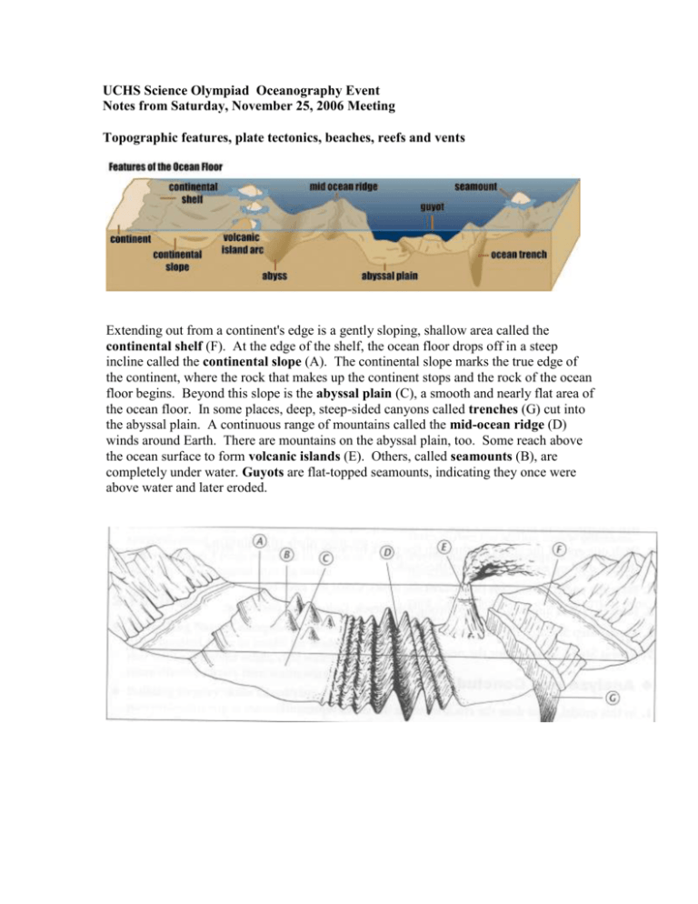
UCHS Science Olympiad Oceanography Event Notes from Saturday, November 25, 2006 Meeting Topographic features, plate tectonics, beaches, reefs and vents Extending out from a continent's edge is a gently sloping, shallow area called the continental shelf (F). At the edge of the shelf, the ocean floor drops off in a steep incline called the continental slope (A). The continental slope marks the true edge of the continent, where the rock that makes up the continent stops and the rock of the ocean floor begins. Beyond this slope is the abyssal plain (C), a smooth and nearly flat area of the ocean floor. In some places, deep, steep-sided canyons called trenches (G) cut into the abyssal plain. A continuous range of mountains called the mid-ocean ridge (D) winds around Earth. There are mountains on the abyssal plain, too. Some reach above the ocean surface to form volcanic islands (E). Others, called seamounts (B), are completely under water. Guyots are flat-topped seamounts, indicating they once were above water and later eroded. Plate tectonics explain how the continental and oceanic plates (together forming the crust, which rides on the mantle) move and collide. Heat from the interior of the earth drives mantle convection, which slides the plates around. The age of the crust reveals the basic patterns of movements: Figure: reds=young rocks; yellows/oranges=next youngest rocks; greens=older rocks; blues=oldest rocks. Convergence occurs when two plates move towards each other. Divergence is the spreading apart of plates, called rifting. Transform faults occur when two plates slide past each other. When Continental plates converge, the crust buckles and dramatic mountain ranges, such as the Himalayas, are formed. When Ocean plate converges with thicker, but lighter Continental plate, it slides underneath in a subduction zone. A subduction zone also occurs when Ocean plates converge, resulting in the formation of curved chains of volcanic islands or Island Arcs. The Ring of Fire is the name given to the volcanic islands around the Pacific that are the result of the subduction of the Pacific Plate. The San Andreas Fault in California is a well-known example of a transform fault (here termed a strike-slip fault), where there no upward deformation of the crust but localized cracks of faults, may occur. A beach is a deposit of loose sediment adjacent to a body of water. Though sand is common to most beaches, a remarkable diversity of sediment size, from boulders to fine silt is found on beaches around the world. Larger particles and steeper slopes are found where wave action is high. Fine particles and gentle slopes are characteristic of beaches exposed to low wave action. A sand spit is a linear accumulation of sediment that is attached to land at one end. Coastlines paralleled by offshore narrow strips of sand dunes, salt marshes and beaches are known as barrier islands. When a bay is closed off by a bar it becomes a lagoon. A sea cliff is a vertical precipice created by waves crashing directly on a steeply inclined slope. Sea caves form along lines of weakness in cohesive but well-jointed bedrock. A sea arch forms when sea caves merge from opposite sides of a headland. If the arch collapses, a pillar of rock remains behind as a sea stack. Beaches extend from the outermost breakers to the landward limit of normal wave and swash action. The beach is generally composed of the backshore, the portion of the beach from the berm crest to the dunes; the foreshore, the portion sloping toward the ocean; and the nearshore, the portion below water, extending seaward to the outermost breakers. The beach profile adjusts rapidly to the wave energy. In general, high waves with short periods cause the beach to erode, and the berm sand is shifted offshore to the bar. Low waves with longer periods, primarily in summer, move sand from the bar and return it to the berm. The average wave height varies on a seasonal basis, resulting in typical "winter" (high energy) and "summer" (low energy) beach profiles. The winter profile is characterized by a narrow backshore, flat foreshore, and a large offshore bar. The summer profile has a wide backshore, a steep foreshore, and a well-developed berm. There are four defined zones in the nearshore environment. When a wave passes from deep to shallow water, it enters the shoaling zone. In this zone the depth of the water is less than half the wavelength. The vertical orientation of the wave changes as it begins to feel the effect of the lake or ocean bottom. As the wave nears the shore, its steepness increases and the wave eventually breaks. Where the wave begins to break is known as the breaker zone. Not all waves begin to break in the same location due to wave height variation. The breaker zone is where the majority of waves reach their steepness limit for a given wave spectrum. After the wave begins to break, it enters the surf zone where water is transported toward the beach in the form of smaller, broken waves known as bores. These bores can be thought of as continually breaking waves. As bores reach the beach, water particles are pushed onshore and then retreat seaward. This area of run-up and backwash of water is known as the swash zone When waves break on the shoreline, they create currents parallel to the shoreline called longshore currents. Longshore currents occur most often when waves approach the shoreline at an angle. The angle of the incoming wave causes a progressively breaking wave that moves along the shoreline and a longshore current that moves in the same direction as the breaking wave. Rip currents are jet-like currents of water that typically extend from near the shoreline out past the line of breaking waves. Rip currents can be caused by several wave phenomena, which include offshore flow through channels in sandbars, natural variability of breaking wave heights, and longshore current interaction with man-made structures. There are three kinds of coral reefs. Fringing reefs are platforms of coral attached to land. They tend to be wider where wave action is prominent and the water well aerated. Barrier reefs form offshore with lagoon in between. Many form along slowing subsiding islands, growing at a rate that keeps them near sea level. Others form on continental shelves. Atolls are circular reefs enclosing a lagoon formed from the subsidence and disappearance of a volcanic island cone. The majority of reef building corals are found within tropical and subtropical waters. These typically occur between 300 north and 300 south latitudes. The red dots on this map show the location of major stony coral reefs of the world. A hydrothermal vent is a geyser on the seafloor. It continuously spews super-hot, mineral-rich water that helps support a diverse community of organisms. Although most of the deep sea is sparsely populated, vent sites teem with a fascinating array of life. Tubeworms and huge clams are the most distinctive inhabitants of Pacific Ocean vent sites, while eyeless shrimp are found only at vents in the Atlantic Ocean. As the vent water bursts out into the ocean, its temperature may be as high as 400°C (750°F). Yet this water does not boil because it is under so much pressure from the tremendous weight of the ocean above. When the pressure on a liquid is increased, its boiling point goes up. Land/sea breezes; Hurricanes; El Nino, La Nina and the Southern Oscillation Sea breeze: warm days heat land, causing rising air; cool air over ocean moves onshore. Land breeze: cool nights cool land, causing sinking air, which moves over sea. Hurricanes: Develop from low-pressure systems (cyclones) in the atmosphere in the tropics. Require very warm water: the evaporating water feeds thunderstorms which speed up the rising air (latent heat release as water condenses into rain). The pressure gradient force increases (low in center, high outside hurricane) which makes the storm spin faster (balanced by Coriolis force). Increased winds then evaporate warm water even more efficiently which creates “positive feedback”, driving stronger thunderstorms, etc. They tend to propagate westward and away from the tropics. El Nino and La Nina are the warm and cold phases of the “sloshing” of the equatorial ocean’s thermocline, combined with the changes in the atmospheric pressure (Southern Oscillation – measured as a difference between Tahiti and Darwin, Australia) and wind fields. El Nino/Southern Oscillation is termed ENSO. El Nino shifts the Walker Cell (atmospheric circulation along the equator, with rising air over warm ocean and sinking air over cold ocean), resulting in drought in Australia and rains in central and eastern tropical Pacific. El Nino alters the Hadley Cell (atmospheric equator-to-midlatitude circulation), causing the Aleutian Low to strengthen and the jet stream to intensify in the Pacific, affecting climate over North America. The strongest effects are in winter. Schematic of Jet Stream enhancement during El Nino winter.

