GIS Assignment 5
advertisement
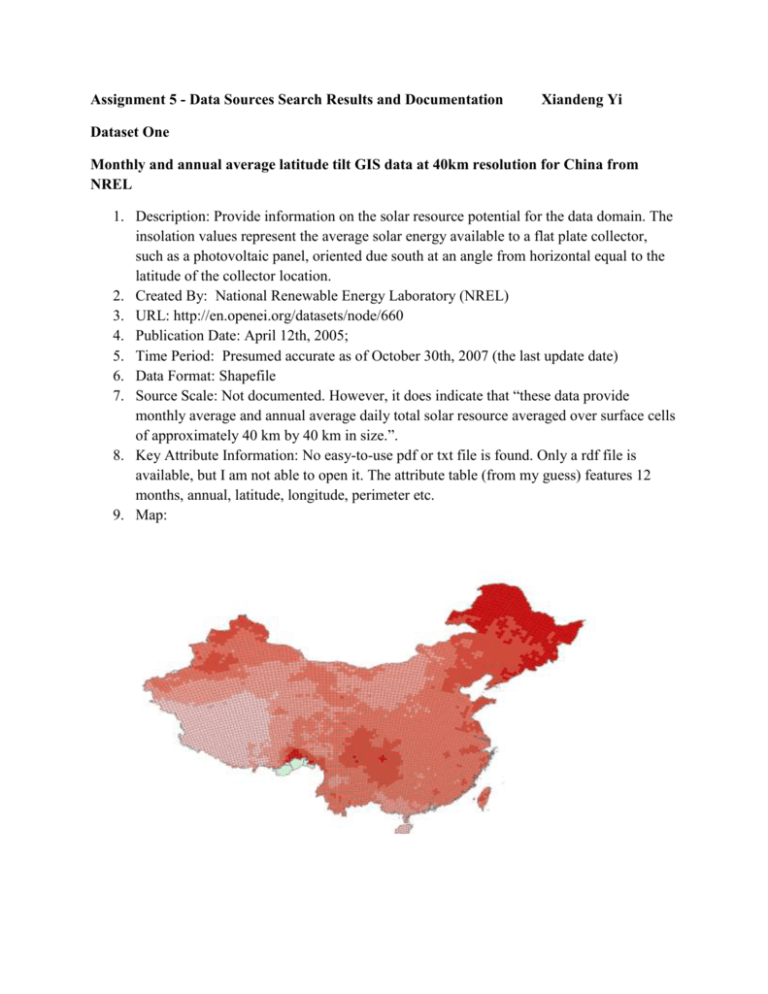
Assignment 5 - Data Sources Search Results and Documentation Xiandeng Yi Dataset One Monthly and annual average latitude tilt GIS data at 40km resolution for China from NREL 1. Description: Provide information on the solar resource potential for the data domain. The insolation values represent the average solar energy available to a flat plate collector, such as a photovoltaic panel, oriented due south at an angle from horizontal equal to the latitude of the collector location. 2. Created By: National Renewable Energy Laboratory (NREL) 3. URL: http://en.openei.org/datasets/node/660 4. Publication Date: April 12th, 2005; 5. Time Period: Presumed accurate as of October 30th, 2007 (the last update date) 6. Data Format: Shapefile 7. Source Scale: Not documented. However, it does indicate that “these data provide monthly average and annual average daily total solar resource averaged over surface cells of approximately 40 km by 40 km in size.”. 8. Key Attribute Information: No easy-to-use pdf or txt file is found. Only a rdf file is available, but I am not able to open it. The attribute table (from my guess) features 12 months, annual, latitude, longitude, perimeter etc. 9. Map: Dataset Two Global Land Cover 2000 – China 1. Description: This dataset provides a landcover map of CHINA with the Spot Vegetation data. 2. Created By: Institute of Remote Sensing Application (IRSA), Chinese Academy of Sciences, 3. URL: http://bioval.jrc.ec.europa.eu/products/glc2000/products.php 4. Publication Date: 12/01/2002 5. Time Period: Starts from 1-1-2000 to 31-12-2000 6. Data Format: Raster 7. Source Scale: Not documented. However, it gives “Spatial Resolution:1km at Equator (0.00892857dd)” 8. Key Attribute Information: very clear and detailed, features include swamp, farmland, glacier, etc. and their responding data and color. 9. Map: Dataset Three River data from Geospatial Toolkit GIS data for China from NREL 1. Description: This dataset consists of a whole set of data. Here I just chose the river data which shows a map of rivers in China. 2. Created By: NREL and its partners (more information is not available. However, there is a SBX file and RDF file which might consist of more metadata, but I cannot open them) 3. URL: http://en.openei.org/datasets/node/660 4. Publication Date: October 31st, 2005 5. Time Period: presumed as of July 06th, 2012 (the latest update) 6. Data Format: Shapefile 7. Source Scale: N/A May be in the RDF or SBX files 8. Key Attribute Information: only partly guessed from shortened spellings like rivers’ location, length, type etc. Metadata may be in the RDF or SBX files. 9. Map: Dataset Four China Wind 50m Resolution 1. Description: This dataset illustrates the annual average wind resource potential for the southeast area of China at a 50 meter height. It can be used to evaluate wind energy development in China. 2. Created By: TrueWind Solutions/NREL 3. URL: <http://www.nrel.gov/gis/cfm/data/GIS_Data_Technology_Specific/International/Wind/ High_Resolution/China_Wind_High_Resolution.zip> 4. Publication Date: November, 2003 5. Time Period: N/A 6. Data Format: vector digital data 7. Source Scale: N/A 8. Key Attribute Information: It has a very detailed metadata file, but attribute description is technically abstract. The first column is the presumably the area (only southeastern China), and the following column may be variables defining the density and direction of the wind. Bounding_Coordinates: West_Bounding_Coordinate: 114.843203 East_Bounding_Coordinate: 121.082229 North_Bounding_Coordinate: 28.168093 South_Bounding_Coordinate: 22.662223 Entity_and_Attribute_Information: Detailed_Description: Entity_Type: Entity_Type_Label: cn_se_50mwind Attribute: Attribute_Label: FID Attribute_Definition: Internal feature number. Attribute_Definition_Source: ESRI Attribute_Domain_Values: Unrepresentable_Domain: Sequential unique whole numbers that are automatically generated. Attribute: Attribute_Label: Shape Attribute_Definition: Feature geometry. Attribute_Definition_Source: ESRI Attribute_Domain_Values: Unrepresentable_Domain: Coordinates defining the features. Attribute: Attribute_Label: ID Attribute: Attribute_Label: GRIDCODE 9. Map:
