Chapter 2 Geographical Characteristics and History
advertisement
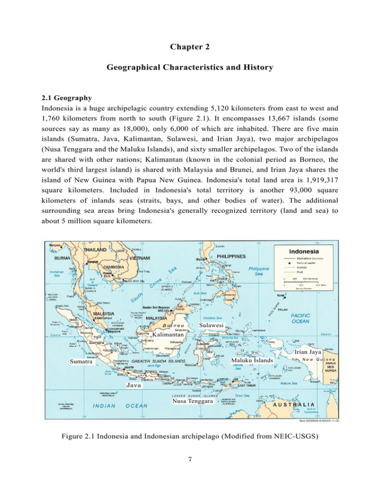
Chapter 2 Geographical Characteristics and History 2.1 Geography Indonesia is a huge archipelagic country extending 5,120 kilometers from east to west and 1,760 kilometers from north to south (Figure 2.1). It encompasses 13,667 islands (some sources say as many as 18,000), only 6,000 of which are inhabited. There are five main islands (Sumatra, Java, Kalimantan, Sulawesi, and Irian Jaya), two major archipelagos (Nusa Tenggara and the Maluku Islands), and sixty smaller archipelagos. Two of the islands are shared with other nations; Kalimantan (known in the colonial period as Borneo, the world's third largest island) is shared with Malaysia and Brunei, and Irian Jaya shares the island of New Guinea with Papua New Guinea. Indonesia's total land area is 1,919,317 square kilometers. Included in Indonesia's total territory is another 93,000 square kilometers of inlands seas (straits, bays, and other bodies of water). The additional surrounding sea areas bring Indonesia's generally recognized territory (land and sea) to about 5 million square kilometers. Sulawesi Kalimantan Irian Jaya Maluku Islands Sumatra Java Nusa Tenggara Figure 2.1 Indonesia and Indonesian archipelago (Modified from NEIC-USGS) 7 The Province of Aceh (officially Nanggroe Aceh Darussalam) covers an area of 57,365 sq km. It is the western most province of the Indonesia with the Indian Ocean to the west, the strait of Malacca to the east. Bukit Barisan mountain ranges with Tangse, Gayo and Alas upland is located in the central part of this province. The highest peaks are Leuser (3,466 m), Ucop Molu (3.187 m), Abong - abong (3.015 m), Peut Sago (2.786 m), and Geureudong Seulawah Agam Kr. Peusangan Kr. Aceh Geureudong Tangse Kr. Peureulak Laut Tawar Peut Sago Kr. Teunom Gayo Kr. Meureubo Abong-abong Alas Leuser Kr. Simpang Kiri Kr. Simpang Kanan Figure 2.2 Physical geography of Aceh Province (Modified from Indo Prima Sarana) 8 (2.295 m) and Burni Telong (2.566 m). Aceh Raya Mountain range with its peak Seulawah Agam (1.762 m) and Seulawah Inong (865 m). This area also has several lakes such as Laut Tawar in Central Aceh, Aneuk Laot in Pulau Weh and Laut Bangko in South Aceh. The rivers running in to the straits of Malacca are Krueng Aceh in the Greater Aceh regency, Kr-Peusangan, Krueng Peureulak, Krueng Tamiang. The rivers running to the Indian Ocean are Krueng Teunom, Kr.Meureubo, Kr. Simpang Kanan and Simpang Kiri. 2.2 Population Although Indonesia seems to be extremely diverse ethnically (more than 300 distinct ethnic groups), most Indonesians are linguistically and culturally part of a larger Indo-Malaysian world encompassing present-day Malaysia, Brunei, the Philippines, and other parts of insular and mainland Asia. Most important, the vast majority of the population can speak Bahasa Indonesia, the official national language. Used in government, schools, print and electronic media, and in multiethnic cities, this Malay-derived language is both an important unifying symbol and a vehicle of national integration. The more than 3.4 million Acehnese are most famous throughout the archipelago for their devotion to Islam and their militant resistance to colonial and republican rule. Renowned throughout the nineteenth century for their pepper plantations, most Acehnese were rice growers in the coastal regions in the early 1990s. Acehnese do not have large descent groups; the nuclear family consisting of mother, father, and children is the central social unit. Unlike the Javanese or Balinese family, the Acehnese family system shows marked separation of men and women's spheres of activity. Traditionally, males are directed outwardly towards the world of trade. 2.3 Climate The main variables of Indonesia's climate are rainfall rather than temperature or air pressure. The archipelago is almost entirely tropical in climate, with the coastal plains averaging 28oC, the inland and mountain areas averaging 26oC, and the higher mountain regions, 23oC. The area's relative humidity ranges between 70 and 90 percent. Winds are moderate and generally predictable, with monsoons usually blowing in from the south and east in June through September and from the northwest in December through March. Typhoons and large-scale storms pose little hazard to mariners in Indonesia waters; the major danger comes from swift currents in channels, such as the Lombok and Sape straits. The extreme variations in rainfall are linked with the monsoons. Generally speaking, there is a dry season (June to September), and a rainy season (December to March). 9 2.4 History Early inhabitants had an agricultural economy based on cereals, and introduced pottery and stone tools during the period 2500 to 500 B.C. During the period between 500 B.C. and A.D. 500, as the peoples of the archipelago increasingly interacted with South and East Asia, metals and probably domesticated farm animals were introduced. Aceh has a fascinating history, which over the centuries has shaped and transformed the region into what it is today. The first Islamic kingdom of Perlak was established in the year 804 about 100 years after Islam is first believed to have reached the archipelago. In 1511, the Portuguese seized the important strategic port of Malacca. Aceh's dominance in trade and politics in northern parts of Sumatra in the entire region had begun and lasted until it reached its zenith between 1610 and 1640. Aceh decline began with death of Sultan Iskandar Than in 1614, and as a result the British and Dutch both began vying for domination of the area. Eventually the signing of the London Treaty in 1824 saw the Dutch gain control of all British possessions in Sumatra in return for their surrender of enterprises in India and withdrawal of all claims on Singapore. Dutch colonists attempted to subdue the rebellious and courageous Acehnese for a long period of time and they never succeeded. The Aceh War, which lasted intermittently from 1873 to 1942, was the longest ever fought by the Dutch costing them over 10,000 lives. The people of Aceh region were one of the foundation stones in Modern Indonesia gaining its independence from Dutch colonists. Nowadays, 70% of the Province of Aceh is forest and precipitous mountains lie especially on the western coast. 16% is farms and rice fields, and rice is harvested three times a year. The population is 4.3 million and the 83% of the people live on the coastal plain isolated by the mountains. There are several races in the Aceh inhabitants. Oil and natural gas production is more than 50% of the gross production of the province, but one-third of the inhabitants is said to be in poverty. 97.7% are Islam and all the women are hiding their hair. An armed group called GAM is insisting on the independence of the Province of Aceh and it repeats conflicts with the Indonesian National Army from time to time. Banda Aceh is the largest city in the Province of Aceh. The population of the city is 260,000. According to the count by the Indonesian government as of April 7, the number of missing and dead in the city is said to come up to 70,000 (missings 20,000 and deads 50,000). 10 References U.S. Library of Congress: http://countrystudies.us/indonesia/ Indo Prima Sarana(2001): Atlas (Indonesia & Dunia) USGS, Political Map of Indonesia: http://neic.usgs.gov/neis/world/indonesia/map.html Atlas of Indonesia (Author of this chapter: Ö. Aydan) 11
