11.2A Folds, Faults, and Mountains
advertisement
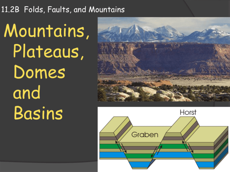
11.2B Folds, Faults, and Mountains Mountains, Plateaus, Domes and Basins Types of Mountains Folding and faulting produce many but not all of Earth’s mountains. In general, mountains are classified by the processes that formed them The major types of mountain types include Volcanic mountains Folded mountains Fault-block mountains Dome mountains Mountain Ranges Types of Mountains : Geologists refer to the collection of processes involved in mountain building as orogenesis. The term is derived from the Greek oros meaning “mountain” and the –geny meaning “born”. Earth’s mountains do not occur at random. Several mountains of similar shape, age, size and structure form a group called a mountain range. Mountain Systems Types of Mountains : A group of different mountain ranges in the same region form a mountain system. The Sangre de Cristo and West Elk mountain ranges form part of the Rocky Mountain system. Sangre de Cristo Mountains Range Rocky Mountain System Volcanic Mountains Recall from the previous chapters that volcanic mountains form along plate boundaries and at hot spots. In addition, igneous activity forms rock deep in the crust that can be uplifted as a result of plate motions and isostatic adjustment. Folded Mountains Mountains that are formed primarily by folding are called folded mountains. Compressional stress is the major cause of folded mountains. Compressional stress helped to form the Alps in Europe. Thrust faulting is also important in the formation of folded mountains, which are often called fold-andthrust belts. Folded Mountains Folded mountains often contain numerous stacked thrust faults that have displaced the folded rocks layers many kilometers horizontally. Stacked thrust faults The Appalachian Mountains, the northern Rocky Mountains, and the Alps in Europe are all examples of folded mountain ranges. Fault-Block Mountains Fault block mountains; another type of mountain formation, is the result of movement along normal faults. Most normal faults are small and have displacements of only a meter or so. Others extend for tens of kilometers where they may outline the boundary of a mountain front. Examples fault block mountains Fault-Block Mountains Large scale normal faults are associated with fault-block mountains Fault-block mountains form as large blocks of crust are uplifted and tilted along normal faults. Examples fault block mountains Grabens and Horsts Normal faulting occurs where tensional stresses cause the crust to be stretched or extended. As the crust is stretched, a block called a graben, which is bounded by normal faults, drops down. Grabens produce an elongated valley bordered by relatively uplifted structures called horsts. Grabens and Horsts The Basin and Range regions of Nevada, Utah, and California is made of elongated grabens. Above the grabens, tilted faultblocks or horsts produce parallel rows of fault-block mountains. Sierra Nevada Range Grabens and Horsts In the western US, other examples of fault block mountains include the Grand Tetons and the Sierra Nevada Range in California. Sierra Nevada Range These steep mountain fronts were produced over 5 to 10 million years by many episodes of faulting. Plateaus, domes, basins Mountains are not the only landforms that result from forces in Earth’s crust. Up and down movements of the crust can produce a variety of landforms, including plateaus domes basins. Plateaus A plateau is a landform with a relatively high elevation and more or less level surface. To form a plateau, a broad area of the crust is uplifted vertically; raised above the adjoining landscape. Colorado Plateau Plateaus can cover very large areas of land such as the Colorado Plateau which stretches over four states. Domes Broad upwarping in the rock underlying an area may deform sedimentary layers. When upwarping produces a roughly circular structure, the feature is called a dome. Domes often have the shape of an elongated oval. You can think of the upwarped layers that make up a dome as a large fold. Basins Downwarped structures that have a roughly circular shape are called basins. The central United States contains a number of basins, including the large Michigan Basin. Michigan Basin Basins During mountain building, plate motions can cause the crust to bend downward and form a basin. If the basin sinks below sea level, it may form a shallow sea. Over time, sediments such as sand and the skeletons of ocean creatures are laid down, forming layers of sedimentary rock. Michigan Basin Basins Basins may also form along the edges of continents where thick layers of sediment build up. The weight of the sediment downwarps the crust to form a basin. When forces in the crust uplift the sedimentary layers, the rock that fills the basin is exposed at the surface. Michigan Basin Basins Look at the map of the Michigan Basin to the right; it resembles a bull’s eye. The oldest rocks are around the edges of the basin and the youngest rocks are near the center. Michigan Basin Basins The plate motions that help to form sedimentary basins can also destroy them. For example, when two continental plates collide, the ocean basin between them closes up. Sedimentary rock in the basin becomes part of the landmass formed by the collision. Michigan Basin
