1T_LocAbRelCornell_CIP
advertisement

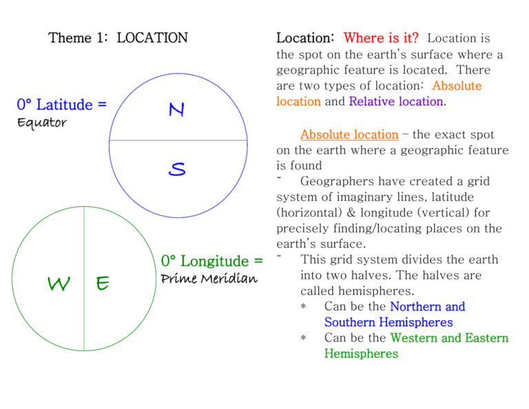
Theme 1: LOCATION 0° Latitude = Equator N S W E 0° Longitude = Prime Meridian Location: Where is it? Location is the spot on the earth’s surface where a geographic feature is located. There are two types of location: Absolute location and Relative location. Absolute location – the exact spot on the earth where a geographic feature is found ˜ Geographers have created a grid system of imaginary lines, latitude (horizontal) & longitude (vertical) for precisely finding/locating places on the earth’s surface. ˜ This grid system divides the earth into two halves. The halves are called hemispheres. * Can be the Northern and Southern Hemispheres * Can be the Western and Eastern Hemispheres Theme 1: Location Finding Absolute Location Absolute location is the exact spot on the earth’s surface where a geographic feature is located. Geographers use a grid system to find absolute location; it is called the Global Grid. The Global Grid is created using imaginary lines called latitude and longitude. LATITUDE Latitude lines – a set of imaginary lines that run east to west and are parallel to the Equator (0° Latitude), used in locating places north and south of the equator. Latitude is measured in degrees, minutes, and seconds. Equator – designated as the zero degree line for latitude Lines north of the equator are called north latitude lines (Ex. 30° N Latitude). These lines will appear only in the Northern Hemisphere. Lines south of the equator are called south latitude lines (Ex. 65° S Latitude). These lines will appear only in the Southern Hemisphere. Latitude lines run only to 90°N (North Pole) and 90°S (South Pole) LONGITUDE Longitude lines – a set of imaginary lines that run north to south and converge at North Pole and the South Pole; used in locating places east and west of the Prime Meridian (0°degrees longitude). Prime Meridian - designated as the zero degree line for longitude. This imaginary lines runs through Greenwich, England. Lines east of the Prime Meridian are called east lines of longitude (Ex. 20° E Longitude). These lines appear only in the Eastern Hemisphere. Lines west of the Prime Meridian are called west lines of longitude (Ex. 45° W Longitude). These lines will appear only in the Western Hemisphere. East & west lines of longitude converge at the Poles and meet the 180° Line of Longitude called the International Date Line. Lines of Longitude Lines of Latitude 0° Latitude 0° Longitude A Simple Grid A simple grid system is a series of horizontal and vertical lines that overlap. This grid is useful in finding location and measuring distance. Grid systems are often used on maps. They can help you find cities or landmark in the area represented on the map. 1. In what coordinate region would you find: a. Brandy Springs - ________________ b. 2. Thompson Estates - _____________ 2. In what two vertical coordinate zones would you find Interstate 83? 3. Can you think of a question to ask the class? Location – The Global Grid Review: The starting point for measuring latitude is the ________________ at ___________ Geographers also use a global grid system of imaginary lines called latitude and longitude. Absolute location – the exact spot on the earth where a geographic feature is found ∞ to describe absolute location, geographers use a grid system of imaginary lines for precisely finding/locating places on the earth’s surface. These lines are called latitude and longitude. degrees latitude. Latitude lines run from __________ to ____________ and measure distance _____________ and _____________ of the equator. Latitude lines measure distance in ____________, minutes and seconds (up to __°). The starting point for measuring longitude is the __________________ at ______________ degrees longitude. Longitude lines run from _________ to __________ and measure distance ___________ and _____________ of the Prime Meridian. Longitude lines measure distance in ____________, minutes and seconds (up to ___°). Location – The Global Grid Review: The starting point for measuring latitude is the Geographers also use a global grid system of imaginary lines called latitude and longitude. Absolute location – the exact spot on the earth where a geographic feature is found ∞ to describe absolute location, geographers use a grid system of imaginary lines for precisely finding/locating places on the earth’s surface. These lines are called latitude and longitude. equator at 0 degrees latitude. Latitude lines run from measure distance east to west and north and south of the equator. Latitude lines measure distance in degrees, minutes and seconds (up to 90°). The starting point for measuring longitude is the Prime Meridian at 0 degrees longitude. Longitude lines run from and measure distance north to south east and west of the Prime Meridian. Longitude lines measure distance in degrees, minutes and seconds (up to 180°). Theme 1: LOCATION Relative location – also a spot (not exact) on the earth’s surface where a geographic feature is found ˜ Relative location must be made in reference to its surroundings, perhaps a place or location you may already be familiar with ˜ Relative location describes the spatial relationships between locations or places and how they are related to their surroundings Can you give a relative location using this map?


