Fluvial Geomorphology
advertisement
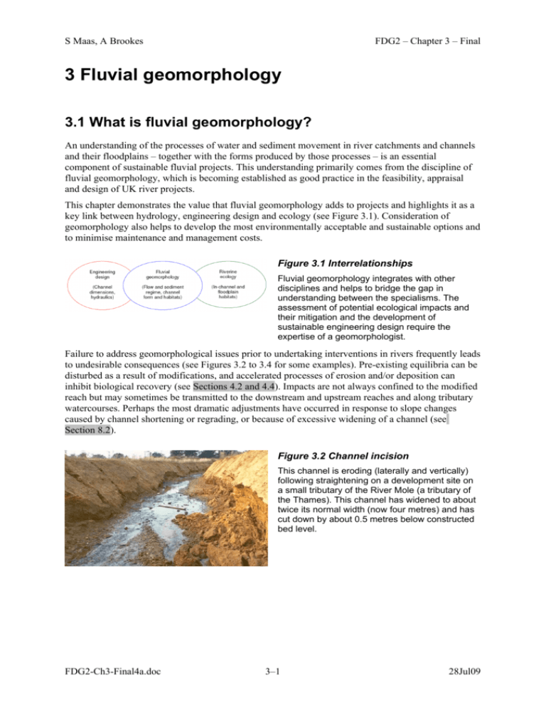
S Maas, A Brookes FDG2 – Chapter 3 – Final 3 Fluvial geomorphology 3.1 What is fluvial geomorphology? An understanding of the processes of water and sediment movement in river catchments and channels and their floodplains – together with the forms produced by those processes – is an essential component of sustainable fluvial projects. This understanding primarily comes from the discipline of fluvial geomorphology, which is becoming established as good practice in the feasibility, appraisal and design of UK river projects. This chapter demonstrates the value that fluvial geomorphology adds to projects and highlights it as a key link between hydrology, engineering design and ecology (see Figure 3.1). Consideration of geomorphology also helps to develop the most environmentally acceptable and sustainable options and to minimise maintenance and management costs. Figure 3.1 Interrelationships Fluvial geomorphology integrates with other disciplines and helps to bridge the gap in understanding between the specialisms. The assessment of potential ecological impacts and their mitigation and the development of sustainable engineering design require the expertise of a geomorphologist. Failure to address geomorphological issues prior to undertaking interventions in rivers frequently leads to undesirable consequences (see Figures 3.2 to 3.4 for some examples). Pre-existing equilibria can be disturbed as a result of modifications, and accelerated processes of erosion and/or deposition can inhibit biological recovery (see Sections 4.2 and 4.4). Impacts are not always confined to the modified reach but may sometimes be transmitted to the downstream and upstream reaches and along tributary watercourses. Perhaps the most dramatic adjustments have occurred in response to slope changes caused by channel shortening or regrading, or because of excessive widening of a channel (see Section 8.2). Figure 3.2 Channel incision This channel is eroding (laterally and vertically) following straightening on a development site on a small tributary of the River Mole (a tributary of the Thames). This channel has widened to about twice its normal width (now four metres) and has cut down by about 0.5 metres below constructed bed level. FDG2-Ch3-Final4a.doc 3–1 28Jul09 S Maas, A Brookes FDG2 – Chapter 3 – Final Figure 3.3 Over-widened channel This artificially straightened channel in Essex is over-wide and has insufficient low flows to support diverse fauna and flora. There is no natural bed material.The current low flow channel is about twice the expected width for a river of this size. An alternative ecologically acceptable design in this location could have been to create a more natural low flow channel (with a gravel substrate) and to pull back the banks in the form of a multistage channel with sufficient capacity to convey the flood flows. Figure 3.4 Inappropriate bank protection Blockstone was used on the outside of this meander bend on the Afon Trannon in Wales to reduce bank erosion and lateral migration of the channel. The relatively high energy system has undermined this artificial protection and continued to erode the bank (flow is from top to bottom of the photograph). No property or infrastructure appears to be at risk, so bank protection may not have been necessary in the first place. Bank erosion is a natural process and adding protection often transfers the erosion downstream, sometimes exacerbating the problem. Awareness of fluvial geomorphology has been raised considerably through the use of a free e-learning tool available from the Environment Agency (http://e-learning.geodata.soton.ac.uk/EA/), which is based on the Guidebook of applied fluvial geomorphology (Sear et al, 2003). Applications of fluvial geomorphology include: environmental impact assessment (EIA) and strategic environmental assessment (SEA); flood risk management strategies and flood alleviation schemes; river sediment management strategies (including bank erosion and in-channel deposition); watercourse realignment; catchment management plans; river and floodplain restoration; monitoring of fluvial systems. The case studies in Section 3.5 provide examples of some of these applications. The case studies range from strategic assessments for new road schemes crossing watercourses and flood risk management strategies, to more detailed reach-scale restoration and monitoring. In these case studies, geomorphology input is promoted at a strategic level to identify pressures and impacts early and to help with the development and appraisal of engineering options. More detailed geomorphological assessments are described for sediment management and flood alleviation studies and highlight the importance of understanding flow and sediment regime to help determine the most FDG2-Ch3-Final4a.doc 3–2 28Jul09 S Maas, A Brookes FDG2 – Chapter 3 – Final sustainable maintenance practices. Other illustrations of applied geomorphology are those of river restoration and rehabilitation and the need for long term morphological monitoring to help guide future designs. Tables 3.1 to 3.3 describe some of the geomorphological techniques used to undertake these studies. These include: catchment baseline surveys; fluvial audits; geodynamics assessment; river reconnaissance. 3.2 Main drivers The two most important concepts behind geomorphology are: conservation (maintaining or restoring natural morphology and habitats); sustainability (minimising maintenance and cost). These principles drive the interest in geomorphology and are now enshrined in legislation. The Habitats Directive (see Section 4.3.2) promotes the maintenance of biodiversity and conservation status, and introduces robust protection for those habitats and species of European importance. Projects can only be permitted if there will be no adverse effect on the integrity of a site. Projects that do have an adverse impact may still be permitted if there are no alternatives, but there must be imperative reasons of overriding public interest. In such cases, compensation measures will be necessary to ensure the overall integrity of the site. Under the Habitats Regulations (see Section 1.4.1), ‘appropriate assessments’ (Regulation 48) are required for rivers designated as ‘special areas of conservation’ (SACs). Planning policy statement 9: Biological and geological conservation (ODPM, 2005) also advocates preservation of natural habitats. Geomorphology or hydromorphology is an important component within the Water Framework Directive (WFD; see Section 4.3.2). Under the Water Framework Directive it is necessary to: assess the status of water bodies; understand the hydromorphological pressures and potential impacts exerted on water bodies and appropriate mitigation measures. Geomorphological input may also be required to obtain authorisation for works on watercourses, for example, in Scotland under the Controlled Activity Regulations. In England and Wales, geomorphological assessments are likely to be required as part of the land drainage consent process. Geomorphological input is necessary if, under the proposed works: water or sediment discharges are altered; the river channel or floodplain is altered in any way; the boundary materials are changed (for example, if some form of bank protection is proposed). It is necessary to consider the sustainability of such works, not only from the geomorphological perspective, but also in terms of the achievement of the hydraulic aims and the whole-life costs. The requirement for a geomorphological input is also driven by Environment Agency policies which address interventions such as: culverting; FDG2-Ch3-Final4a.doc 3–3 28Jul09 S Maas, A Brookes FDG2 – Chapter 3 – Final removal of gravel from rivers (policy statement 359_04, 2004); in-stream structures (policy statement 606_06, 2006). 3.3 Role of geomorphology in fluvial design This chapter provides only an introduction to geomorphology and it is strongly recommended that a qualified geomorphologist is brought in to advise on any significant interventions. It gives examples of tools devised to assist geomorphological inputs for: strategy studies; options appraisal; feasibility studies; outline and detailed design; construction; post-project appraisal. These tools typically use a mixture of science, empiricism and expert judgement. Some geomorphological tools can also serve as a screening mechanism by which a small percentage of cases (probably less than 5%) are identified for more sophisticated and costly data collection and sediment modelling. A geomorphologist typically asks the following four key questions: To what extent is the issue affected by sediment derived from the upstream catchment? To what extent do local geomorphological factors contribute to the issue or intervention? What are the geomorphological impacts likely to be over the design lifetime of the works? What are the likely impacts of any mitigation measures proposed? The morphology and dynamics of the fluvial system are controlled by several interrelated variables. The transport of sediment and water over the land surface and within river channels is also affected by human activities. For example, empirical studies have shown that covering part of a catchment with impermeable surfaces as a consequence of urbanisation typically increases the frequency and magnitude of water runoff (see Section 2.2.3), causing downstream channel adjustment in the medium to long term. Typically, given an erosive bed or banks, a channel may enlarge as a result. Although geomorphological assessments are based on science, the large number of variables involved ensures there will be significant uncertainties and designers need to be aware of these. 3.4 Tools A number of recognised geomorphological tools are now applied in the UK (see Figure 3.5), both at a catchment or strategic scale and at a reach or project scale. It is important that geomorphology is considered during the early, strategic stages of a project in order to maximise sustainability and to minimise costs (both project and maintenance). Tables 3.1 to 3.3 describe the geomorphological tools in more detail. Geomorphological input should be integral to the options appraisal, feasibility and design of a project where the river discharge, sediment load, channel or floodplain dimensions, or channel boundaries are affected. FDG2-Ch3-Final4a.doc 3–4 28Jul09 S Maas, A Brookes FDG2 – Chapter 3 – Final Figure 3.5 Geomorphological tools A range of geomorphological tools is available for studies at different scales and for different applications. Catchment and strategy scale studies can be applied to catchment flood management plans (CFMPs), strategic environmental assessments (SEAs) environmental impact assessments (EIAs) (see Section 3.5.1 for case study) and flood risk management strategies (see Section 3.5.2 for case study). Scheme (or project) scale studies are generally more detailed and focus on a project reach affected by a flood alleviation scheme or where a maintenance issue needs to be addressed. Although procedures have been broadly defined in terms of aims and methods, the approaches are flexible and can be tailored to the specific objectives of a project and client requirements. A catchment baseline survey (see Section 3.5.1 for case study) provides an overview of the geomorphological state of a river network and includes an assessment of the sensitivity and conservation value of a channel and associated riparian zone. It is often used to support strategic decisions (eg SEA and EIA). A more detailed catchment assessment is a fluvial audit (see Section 3.5.3 for case study), which focuses on the sediment regime, including semi-quantitative information on sources and storage. The method is often adapted to inform wider habitat enhancement and catchment management issues, as well as causes of instability and sediment-related problems. A river habitat survey (RHS) can be used to characterise and assess the physical structure of freshwater streams and rivers. Survey lengths of 500m can be undertaken back-to-back for a continuous reach assessment along a river corridor, or more disparately for a catchment overview or strategy scale study. GeoRHS captures more river and floodplain geomorphology data than the standard RHS and can be used for a range of projects. RHS or GeoRHS surveys can also be repeated and used as a monitoring technique to assess change over time. There are also tools providing more detailed geomorphological assessment on a selected or project reach, rather than the whole system (Table 3.1). River reconnaissance surveys can be used for impact assessment as well as post-project monitoring and for detailing the most important morphological features and processes (see Section 3.5.6 for case study). The bank assessment method is a well-established stepwise approach, and helps assess and identify the most appropriate bank protection or remediation methods for a site. It is widely used by British Waterways and the Environment Agency. A geomorphological dynamics assessment is an intensive assessment – often comprising repeat surveys, basic stream power estimates, and hydraulic and sediment modelling (see Chapter 7 for details of hydraulic modelling) – to gain a thorough understanding of a river’s behaviour to help forecast future responses and impacts. This kind of study is applied to projects where the geomorphology is complicated, or in larger projects where the cost of the study is relatively small compared with the potential cost savings because of the geomorphological advice (for example, the Carlisle flood alleviation scheme described in the case study in Section 3.5.4). A good knowledge of geomorphological processes and the flow and sediment regime is also essential when designing a sustainable restoration scheme (see Section 8.4). Channel design should build on previous geomorphological assessments and use topographic surveys and site investigations to ensure FDG2-Ch3-Final4a.doc 3–5 28Jul09 S Maas, A Brookes FDG2 – Chapter 3 – Final that appropriate channel dimensions, planform and morphological features are proposed. Provision should be made for geomorphological monitoring in a project programme and budget at the design stage. This applies not just to restoration schemes, but to all schemes with significant potential impacts on the fluvial environment. The level and duration of monitoring depends on the scale of study and potential risks or impacts, and ranges from fixed photography to full topographic resurveys and ecological sampling. (The need for monitoring is discussed in Section 4.6). Monitoring allows channel change to be identified and evaluated, and potential mitigation measures to be recommended and is often part of post-project appraisal. This appraisal process helps to evaluate success of a project in achieving the short-term objectives and whether it is likely to be sustainable in the longer term. Monitoring and post-project appraisal are good practice and are invaluable in learning lessons for future projects. They should be integral to all capital works and significant maintenance operations (see Section 3.5.5 for an example of long-term monitoring). Hydraulic and sediment modelling can be used to enhance geomorphological approaches where necessary, although these are often time-consuming and costly. These more sophisticated approaches are often triggered by an initial geomorphological assessment but can be undertaken in parallel. 3.5 Case studies 3.5.1 Catchment baseline survey: EIA Recent geomorphological contributions to environmental statements have included new road schemes and reservoirs crossing watercourses. The objective of the geomorphology assessment is to incorporate current Water Framework Directive requirements and targets for water quality and hydromorphology. The example shown in Figure 3.6 is for a new road widening project affecting three watercourses in East Sussex. The potential construction and operational impacts of the road widening project in East Sussex were assessed against the baseline characteristics (vulnerability) of each watercourse in terms of: sediment regime – major, moderate or minimal impacts to the riverbed over the reach due to accelerated deposition or erosion and/or impacts to sensitive species or habitats as a result of changes to suspended sediment load or turbidity; channel morphology – major, moderate or limited impacts to the diversity of channel morphology, with consequences for ecological quality; natural fluvial processes – major, moderate or minimal interruption to the fluvial processes, such as channel planform evolution or erosion and deposition. The findings of the baseline survey and a desk study were then used to inform design development, to assess potential impacts in terms of sensitivity and magnitude and contribute to the identification of mitigation measures for the project. This process was achieved through close liaison between the road design team, geomorphology, water quality and ecological specialists, thus ensuring a holistic (and sustainable) approach early in the project design stage. The types of mitigation achieved included determining an appropriate angle of culvert issuing from under the road embankment and the type of bed and bank protection within the footprint of the scheme. FDG2-Ch3-Final4a.doc 3–6 28Jul09 S Maas, A Brookes FDG2 – Chapter 3 – Final Figure 3.6 Highly vulnerable stream on the proposed road scheme This stream in the immediate vicinity of the new road scheme in East Sussex has been classified as moderately sensitive. This watercourse exhibits a range of morphological features such as pools and riffles, depositional bars formed from gravel, sand or silt and berms, backwaters, complex riparian zones and varied riverbank types. Such morphological variability is a primary determinant of ecological diversity. Where possible, such morphological and ecological diversity was conserved. Where not possible, the potential impacts of the scheme were identified and appropriate mitigation measures sought. 3.5.2 Geomorphology scoping study: flood risk management strategies Scoping studies have been undertaken for the Soar and Derby flood risk management strategies to assess the dominant geomorphological processes and to help with the development of flood alleviation options. These studies were ‘high level’ and consisted of a brief desk study and a one-day site visit. This allowed the geomorphologist to gain a broad understanding of the river and to be able to contribute to the development and appraisal of options. Options included: weir lowering or removal to improve continuity; setting back embankments and regrading banks to improve floodplain connectivity and increase flood storage. Opportunities to restore or enhance previously engineered sections of the river were also identified to help achieve Water Framework Directive objectives. 3.5.3 Fluvial audit: Rivers Irwell and Roch gravel management plans A fluvial audit was carried out to: determine a basic sediment budget for the Upper Irwell and River Roch in northwest England; identify areas of high flood risk; evaluate the relationship between flooding and in-channel sedimentation. The study was commissioned by the Environment Agency to evaluate the need for channel dredging and to aid the development of a more sustainable maintenance plan. An understanding of external and internal ‘controls’ is essential to interpret river behaviour correctly and to design sustainable solutions. External controls include: catchment form; drainage network; flora and fauna; land use; FDG2-Ch3-Final4a.doc 3–7 28Jul09 S Maas, A Brookes modification; management practices. FDG2 – Chapter 3 – Final Internal controls include: stream gradient; mode of adjustment; cross section morphology; bed and bank conditions; floodplain connectivity; river continuity; flow regime. The desk study for the fluvial audit of the Upper Irwell and River Roch included information on: geology and soils; hydrology and water resources (covering flood history and flood protection); historical channel change; environmental designations and land use; past and present maintenance operations. The fieldwork incorporated a walkover survey. The data collected included the location of sediment sources and sinks (point, diffuse and data on material size) in order to develop a sediment budget. Figure 3.7 shows the basic sediment budget for the River Roch. Information on channel and riparian modifications (in-channel structures, bridges, management) was also recorded and used with the desk-based information to create watercourse summaries detailing physical character, historical change, geomorphological behaviour and significant issues. Figure 3.7 Basic sediment budget for the Upper Roch The volume of sediment sources and sediment sinks (area of deposition) were estimated to develop a basic sediment budget. Other sediment sources included in the diagram refer to tipped debris, cattle poaching and collapsed walls. There were significantly more sinks than sources, and most of these were in the form of berms (permanent marginal deposits) and semi-permanent bars. This implies that the sediment supplied to the channel is stored rather than being transferred through the system, suggesting that the channel is over-wide. Deposition has caused narrowing of the active flow width and this width now reflects the current flow and sediment regime. FDG2-Ch3-Final4a.doc 3–8 28Jul09 S Maas, A Brookes FDG2 – Chapter 3 – Final The main findings and conclusions were as follows. The flood risk is exacerbated by the in-channel structures (low bridges and culverts) rather than the build up of sediment in the channel. The main deposition areas do not correlate to the flooding hot spots. The channels have been engineered over-wide and are re-adjusting by developing marginal berms and reducing the channel width by approximately a third. This reflects a low flow width appropriate for the hydrological regime, improving the efficiency of the channel to transport sediment downstream. It was recommended that these berms should be preserved. A relatively high proportion of the coarse sediment in the channel is supplied from collapsing walls. These were built to channelise the flow during the height of industrialisation in the area but are now not being maintained. Source management was suggested in priority areas where the supply was accelerated due to human intervention. Box 3.1 Example action plan This site on a tributary of the River Roch was described in terms of problem, contributing factors, proposed solutions, and constraints and risks. The main issues at this site included: severe bank erosion; damage to revetments and bridges caused by a flood. This resulted in a high volume of sediment being supplied to the channel which could be transported over time to potentially pose a flood risk to a downstream culvert. Possible solutions include source management (stabilising walls and channel banks) and monitoring sediment movement. This sediment provides morphological diversity and should only be removed from the channel if it is transported downstream and blocks the culvert entrance. FDG2-Ch3-Final4a.doc 3–9 28Jul09 S Maas, A Brookes FDG2 – Chapter 3 – Final The geomorphological survey was used to produce a user-friendly action plan (Box 3.1) which: described how geomorphology affects river maintenance; summarised the flood risk, current river management and geomorphology in the catchment; identified and prioritised specific sites or reaches where improvements could be made and recommended a list of actions. 3.5.4 Geomorphological dynamics assessment: Carlisle flood alleviation scheme In January 2005, the city of Carlisle suffered severe flooding from the Rivers Eden, Petteril and Caldew when over 1600 residential properties were affected. It is believed that some 3000 properties across the city may be at risk of flooding during a 1% annual exceedance probability (AEP) event (1 in 100 chance of occurring in any year). The accumulation of sediment in the lower reaches of the River Caldew (see Figure 3.8) is perceived to be reducing channel capacity and exacerbating flood risk in central Carlisle. Dredging to remove sediment has been a regular maintenance practice in the past but this is unsustainable both on environmental and cost grounds. A geomorphological study, together with the development of a one-dimensional sediment model, was commissioned by the Environment Agency to: test the relationship between sediment accumulation and flood risk; investigate the potential impact of various flood risk management options from both an engineering and environmental perspective. The geomorphological assessment included a review of historical maps, aerial photographs and local authority and national records for the study area. A 14km walkover survey was undertaken to map: geomorphological features – bare and vegetated bars, mature deposits and islands, eroding and stable banks, and changes in slope; channel structures and engineering. The information was mapped using GIS in the field directly onto a tablet PC. Figure 3.8 River Caldew Deposition of bedload carried during the flood has caused normal to moderate flows to be deflected to the opposite bank causing erosion. The Caldew is a high-energy and dynamic river, partly due to a steep bed gradient. The combination of high energy and relatively unconsolidated bed and bank material prompts rapid channel change, particularly in times of flood. The historical map and aerial photograph analysis showed how the course of the channel has changed over time. Analysis of the resulting data (including stream power equations and developing a sediment budget) enabled the identification of: factors influencing channel behaviour; FDG2-Ch3-Final4a.doc 3–10 28Jul09 S Maas, A Brookes phases of past channel change; mechanisms of change; potential channel responses. FDG2 – Chapter 3 – Final These inferences about the nature, rate and causes of geomorphological processes helped validate the sediment transport model. The one-dimensional sediment model used 130 topographic cross sections representing approximately 4km of the downstream reach of the River Caldew and 2km of the River Eden. Flow and suspended sediment data provided upstream boundary conditions for simulations and sensitivity analysis, and return period events were derived using Flood estimation handbook methods (see Section 2.4). Bed sediment samples were also collected from six locations to validate the model. The model was tested under two scenarios to assess the impact a build-up of existing gravel and vegetation may have on the standard of protection. Some sensitivity testing was also undertaken. The conclusions from the geomorphological assessment (see Figure 3.9) and sediment modelling (see Figure 3.10) helped to inform the most appropriate flood alleviation scheme and the maintenance management plan. Figure 3.9 Geomorphology mapping Morphological features and channel modifications on the River Caldew were mapped on aerial photographs to assess recent channel change. FDG2-Ch3-Final4a.doc 3–11 28Jul09 S Maas, A Brookes FDG2 – Chapter 3 – Final Figure 3.10 Sediment modelling The graph shows the bed elevation results from a 5-year and 12-year simulation of flows on the River Caldew. The longitudinal section has been divided into sediment process zones A, B and C. The rates of sedimentation presented are an indication of the average maximum likely rates of sedimentation within areas of the defined zones. It was considered that the relatively dynamic sections of the River Caldew, where erosion and deposition occur, can be allowed to evolve naturally. Sediment accumulation is currently limited in Carlisle and the river channel is now in a state of dynamic equilibrium. Deposition in Carlisle is likely to be concentrated on the surface of existing vegetated deposits, berms and islands. A programme of vegetation maintenance (see Section 8.2.2) and monitoring of deposits was therefore recommended with the aim of retaining the existing vegetation density and current berm levels. 3.5.5 River restoration and long-term monitoring: River Cole A section of the River Cole near Swindon was restored in the mid-1990s as part of a European Union demonstration project. The artificially straightened channel was replaced with a freely meandering planform with more natural bends and varied cross sections, and an improved degree of connectivity between the river and the floodplain (see Figure 3.11). Figure 3.11 River Cole restoration scheme This channel was reprofiled and regraded. More information about the scheme (including the postproject monitoring) can be obtained at http://www.therrc.co.uk/projects/cole_brochure.pdf The River Cole provided (and still provides) a unique focus for long-term monitoring and evaluation that has helped guide future designs. Morphological, hydrological and biological monitoring before, during and after construction of any project provides useful information to help assess the success of a restoration project (providing objectives have been set). The morphology and ecology can be improved through river restoration activities and flood risk can be reduced. There can also be significant community benefits. Successful river restoration depends on an intelligent holistic approach, integrating fields such as hydrology (Chapter 2), fluvial ecology (Chapter 4), landscape character (Chapter 5), and hydraulic analysis and design (Chapter 7). FDG2-Ch3-Final4a.doc 3–12 28Jul09 S Maas, A Brookes FDG2 – Chapter 3 – Final Details of the River Cole scheme and other examples of river restoration can be obtained from the River Restoration Centre (http://www.therrc.co.uk). 3.5.6 River reconnaissance: Lower Colne River reconnaissance surveys were undertaken on the River Wraysbury at Poyle as part of the Lower Colne flood alleviation scheme. The works completed in the early 1990s incorporated a number of measures to mitigate the effects of widening the existing channel to accommodate flood flows. The initial reconnaissance surveys were carried out prior to options appraisal and design. They involved walking the proposed scheme length (150m) and about 500m of channel upstream and 500m downstream. These walkovers helped to establish a key parameter – an acceptable low flow width for the channel. The reconnaissance surveys also established that there was a high silt load in the river and associated vegetation growth. The geomorphological contribution to the scheme involved designing a series of rock deflectors (groynes) (see Figure 3.12) to trap this sediment and to assist in narrowing and fixing the low flow width. This sinuous low flow channel was also excavated 200mm below bed level to accommodate low flows for environmental reasons. Repeat reconnaissance surveys showed that, as anticipated, the deflectors had caused localised silt deposition, maintaining a central gravel area largely clear of fine silt. Marginal plant species have tended to colonise the silt, forming berms. These subsequent surveys demonstrated that the design has functioned over at least 10 years with a reduction in sedimentation and flood risk downstream. Figure 3.12 River Wraysbury deflectors Stone deflectors were used on the River Wraysbury to narrow the channel and to create a more efficient channel without significantly comprising flood flow capacity. The hydraulic design allows for some vegetation growth so that frequent cutting is not necessary. The Wraysbury example and other case studies are described in Bringing your rivers back to life: A strategy for restoring rivers in north London (http://www.london.gov.uk/mayor/environment/bio diversity/docs/restoring-rivers-nlondon-envagency.pdf) The hard bank protection on the outside of the bend was positioned to protect property and a potential rail link to Heathrow on the adjacent floodplain. More rural locations would not require such robust bank protection. FDG2-Ch3-Final4a.doc 3–13 28Jul09 S Maas, A Brookes FDG2 – Chapter 3 – Final 3.6 Conclusions Geomorphology (understanding of channel form and processes) plays a key role in river management problems and solutions, and is essential to achieving the requirements of the Water Framework Directive. Input from a geomorphologist helps evaluate potential ecological impacts and suitable mitigation measures to ameliorate those impacts. Rivers are stochastic in nature; every design will be unique and needs to be tailored to local environmental characteristics and conditions. Although there are many successful examples of mitigation and restoration projects, there is still a need for pre- and post-scheme monitoring to add further certainty of successful implementation of some of the measures. Key references Brookes, A and Shields, D A (eds) (1996). River channel restoration: guiding principles for sustainable projects. John Wiley and Sons. This book provides practical guiding principles for river managers summarising river channel, floodplain and catchment restoration. Fundamental principles are illustrated with case studies and experiences in a wide range of settings, principally Northern Europe and North America. An objective is to guide river managers away from trial-and-error approaches to appraisal and design. It also highlights that a multi-functional approach to restoration projects is needed, encompassing disciplines such as hydrology, hydraulics, geomorphology, water quality, ecology and landscape. River Restoration Centre (2002). Manual of river restoration techniques [online]. RRC. Available from: http://www.therrc.co.uk/rrc_manual_pdf.php [Accessed 18 December 2008]. The first edition of the manual (1999) was dedicated to the techniques utilised in restoring the Rivers Cole and Skerne in 1995. The updated version incorporates over 20 techniques taken from 15 different projects and covering examples from a range of river types. The techniques are arranged in 11 separate parts of the manual, each encompassing a significant activity or objective that may typically be included in a restoration project brief (for example, Part 4 Revetting and supporting river banks). Each part contains examples of techniques that may be useful in achieving the objective (for example, Part 4.1 Spiling revetment). Royal Society for the Protection of Birds, National Rivers Authority and Royal Society for Nature Conservation (1994, reprinted 2001). The new rivers and wildlife handbook. RSPB. The handbook is a practical guide to techniques of river management that integrate the requirements of flood defence, wildlife and other river interests. The handbook provides an updated guide to environmentally sensitive river management practices that should be adopted by water management bodies. Many of the techniques described have now been adopted as standard practice by flood risk management engineers. The new handbook is founded on ‘best practice’ principles contained in the first edition published in 1984. Most importantly, the second edition uses various case studies to evaluate the success of the range of techniques currently employed in both ecological and engineering terms. Sear, D A, Newson, M D and Thorne, C R (2003). Guidebook of applied fluvial geomorphology. Defra/Environment Agency R&D Technical Report FD1914. Defra. Available from: http://sciencesearch.defra.gov.uk/Document.aspx?Document=FD1914_1147_TRP.pdf [Accessed 18 December 2008]. This guidebook collates and summarises the results of geomorphological R&D projects performed for the Environment Agency and its predecessor, the National Rivers Authority, during the 1990s. Its aims are to: foster a general interest in and understanding geomorphology in the river environment; FDG2-Ch3-Final4a.doc 3–14 28Jul09 S Maas, A Brookes FDG2 – Chapter 3 – Final develop a realisation of the significance of considering geomorphological processes in river management applications; give an overview of the different methods of incorporating geomorphological science into river engineering and management; provide guidance on when to seek expert geomorphological advice and where to find it. Thorne, C R, Hey, R D and Newson, M D (eds) (2000). Applied fluvial geomorphology for river engineering and management. John Wiley and Sons. This book provides river engineers and managers with an overview of fluvial geomorphology and gives useful insights into, and understanding of, natural channel forms and fluvial processes. The book incorporates material on methods and techniques of data collection, analysis and interpretation, making extensive use of case studies throughout. Other references Downs, P W and Thorne, C R (1996). A geomorphological justification of river channel reconnaissance surveys. Transactions of the Institute of British Geographers, New Series Vol 21, pp 455–468. Environment Agency (1998a). Sediment and gravel transportation in rivers: a procedure for incorporating geomorphology in river maintenance, Guidance Note 23. Environment Agency National Centre for Risk Analysis and Options Appraisal. Environment Agency (1998b). River geomorphology: a practical guide, Guidance Note 18. Environment Agency National Centre for Risk Analysis and Options Appraisal. Environment Agency (1999). Waterway bank protection: a guide to erosion assessment and management, R&D Project W-5-635. Environment Agency. Environment Agency (2004). Environment Agency Policy – The removal of gravel from rivers, Policy N° 359_04. Environment Agency. Available from: http://www.intertidalmanagement.co.uk/contents/management_processes/pdfs/risks%20benefits/359_ 04.PDF Environment Agency (2006). Environment Agency Policy – Policy on in-stream structures, Policy N° 606_06. Environment Agency. Available from: http://www.intertidalmanagement.co.uk/contents/management_processes/pdfs/screening%20assessme nt/606_06.pdf Environment Agency, SEPA and Environment and Heritage Service (2003). River habitat survey in Britain and Ireland. Field survey guidance manual 2003 version. Environment Agency. Available from: http://www.environment-agency.gov.uk/static/documents/Leisure/surveyforms_1445223.pdf [Accessed 18 December 2008]. Federal Interagency Stream Restoration Working Group (2001). Stream corridor restoration. Principles, processes and practices. FISRWG (first published 1998). Available from: http://www.nrcs.usda.gov/technical/stream_restoration/newtofc.htm [Accessed 18 December 2008]. National Rivers Authority (1993). Draft guidelines for the design and restoration of flood alleviation schemes, R&D Note 154, prepared by R D Hey and G L Heritage. NRA. Office of the Deputy Prime Minister (2005). Planning policy statement 9: Biological and geological conservation. ODPM. Available from: http://www.communities.gov.uk/planningandbuilding/planning/planningpolicyguidance/historicenviro nment/pps9/. FDG2-Ch3-Final4a.doc 3–15 28Jul09 S Maas, A Brookes FDG2 – Chapter 3 – Final Skinner K, Shields, F D Jr and Harrison, S (2008). Measures of success: uncertainty and defining the outcomes. In River restoration: managing uncertainty in restoring physical habitat (S Darby and D Sear, eds), chapter 10. John Wiley and Sons. Thorne, C R (1998). Stream reconnaissance guidebook: geomorphological investigation and analysis of river channels. John Wiley and Sons. FDG2-Ch3-Final4a.doc 3–16 28Jul09 S Maas, A Brookes FDG2 – Chapter 3 – Final – Tables Table 3.1 Catchment and strategic-scale geomorphology tools Tool River habitat survey (RHS) and GeoRHS Catchment baseline study Fluvial audit Aim Strategic overview of the river channel morphology and classification of geomorphological conservation value Can be used to determine how the river will be affected by development proposals, changes in maintenance operations or capital works for flood defence or land drainage. A catchment-based approach, with each reach defined by its geomorphological characteristics Method typically used to focus on sediment-related management problems. Qualitatively identifies sediment source, transfer and storage reaches within the river network, including the impact of flood events and impacts of land use change. Broad characterisation and assessment of the physical structure of freshwater streams and rivers GeoRHS is the geomorphology component bolt on to RHS. It largely targets features and dimensions that relate to the processes of sediment transport in the channel and floodplain. Method Desk study: data collection and examination of information on geology, soils, topography and land use, etc. Field survey: morphological data collection to subdivide the channel network into reaches of similar character and help to identify a conservation value. Desk study: documentary evidence on catchment and channel changes including flood defence, land drainage and maintenance operations, as well as historic maps and aerial photographs. This information aids the development of a time chart of catchment changes and is used to assess potential issues and destabilising mechanisms. Field survey: detailed studies of sediment sources, sinks, transport processes, floods and land-use impacts on sediment system to verify or reject evidence of channel response to potential destabilising factors. Survey can be tailored to project aims and client needs. Desk study: recommended for GeoRHS that incorporates remote sensing. Field survey: standardised inventory sheet to assess 500m reaches of river with more detailed recording of channel, bank, river corridor (and floodplain) information every 50m at spot checks. Outputs Catchment geomorphological conservation map Short report detailing findings (GIS) map including georeferenced photographs Time chart of catchment changes Geomorphological classification map Report detailing findings, interpretations and recommendations (GIS) map including georeferenced photographs Four-page survey sheet, with an additional three pages for GeoRHS Photographs are also submitted for each site. FDG2-Ch3-Final4a.doc 3–17 28Jul09 S Maas, A Brookes FDG2 – Chapter 3 – Final – Tables Application Feasibility studies for rehabilitation/ restoration Input to CFMPs, SEAs or EIAs. Catchment and river management (land management, sediment maintenance, fisheries, etc.) Inventory of features to inform EIAs, feasibility studies Provides baseline information on biodiversity and modification and could be used for compliance purposes. Reference material Environment Agency, 1998b Sear et al, 2003 Environment Agency, 1998a Environment Agency, 1998b Sear et al, 2003 Environment Agency/SEPA/ Environment and Heritage Service, 2003 Table 3.2 Project-scale geomorphology tools Tool River reconnaissance Geomorphological dynamics assessment Aim A rapid geomorphological survey of a reach, noting the contemporary morphological forms and identifying the predominant geomorphic processes Supports techniques of geomorphological classification, analysis and prediction necessary to promote sustainable river engineering, conservation and management. To provide a detailed intensive small-scale assessment of the channel in a problem reach, identified through a catchment baseline survey or fluvial audit. The assessment provides quantitative guidance on stream power, sediment transport and bank stability processes, with the aim of understanding the relationships between reach dynamics and channel morphology. To assess bank erosion processes and determine appropriate solutions. Method Field survey: series of recording sheets which focus in depth on the riverbed and bank features, but encompasses valley and riparian information. Often undertaken on a project reach basis, but usually includes upstream and downstream reaches and could be scaled up to catchment size, more akin to fluvial audit. Field survey: channel form and flows; hydrological and hydraulic data; bank materials and bed sediments, but largely tailored to the specific case in question. May require an intensive period of survey, measurement and/or monitoring to identify the cause of the problem, assess potential morphological evolution and impacts and suggest sustainable solutions. The study is ideally undertaken over one year to assess for seasonal change. Field survey: a step-by-step field manual is used to evaluate the problem, establish predominant processes and type of bank failure. FDG2-Ch3-Final4a.doc 3–18 Bank assessment methodology 28Jul09 S Maas, A Brookes FDG2 – Chapter 3 – Final – Tables Outputs Information on impetus of project (i.e. problem); reconnaissance forms for reaches of interest; geo-referenced photographs, sketch map showing river and any significant issues; interpretations and recommendations. Detailed investigative report and justification of management actions, including monitoring results. Report detailing bank erosion assessment, interpretations, recommendations for a sustainable solution and geo-referenced photographs. Application Adaptable tool to assess the impact of a whole variety of project-related activities, particularly at reach scale. If the potential impact is extensive, a catchment-scale assessment such as fluvial audit is recommended. Impact assessment of small-scale activities (such as river crossings or in-stream works). Bank modification activities and bank failure. Reference material Thorne, 1998 Downs and Thorne, 1996 Environment Agency,1998b Environment Agency, 1999 Sear et al, 2003 Environment Agency, 1999 FDG2-Ch3-Final4a.doc 3–19 28Jul09 S Maas, A Brookes FDG2 – Chapter 3 – Final – Tables Table 3.3 Detailed scheme-scale geomorphology tools Tool Geomorphological channel design Geomorphology monitoring Post-project appraisal Aim To design channels within the context of the basin sediment system and local processes. Provides information on the change in form and processes during and after project completion. Forms part of the post-project appraisal. Assesses the degree of compliance between design expectation and outcomes (performance) in terms of geomorphological processes, dimensions and processes. Method Desk study: Review of baseline survey/fluvial audit/river reconnaissance and information on geology, soils, etc. Analysis of topographic survey and habitat survey; Flood risk analysis. Field survey: detailed (quantitative) description of channel dimensions and location of features, substrates, revetments, etc. Field survey: a number of methods can be used to assess channel change including: fixed point photographs; cross section survey; erosion pins/photo-electronic erosion pins; topographic surveys; river reconnaissance sampling; bed substrate sampling; sediment transport monitoring. Review of project aims and expectations. Re-survey and analysis of project datasets. Outputs Plans, drawings, tables and a report suitable as input to quantity surveying and engineering costings. Appropriate channel and floodplain features and dimensions as required within a functionally designed channel. Drawings, tables and report describing morphological and ecological changes (for example, flow and habitat diversity). Identification of potential issues and recommendations for mitigation Plans, table and report describing the extent of changes or conformity to original project design and recommendations for mitigation options (if appropriate) Application River restoration, realignment River restoration – although monitoring should be considered during and after all activities. Helps to establish how successful the project has been and provide lessons for future management. Reference material National Rivers Authority, 1993 Brookes and Shields, 1996 River Restoration Centre, 2002 FISRWG, 2001 RSPB, NRA and RSNC, 1994 Skinner et al, 2008 Environment Agency, 1999 Skinner et al, 2008 FDG2-Ch3-Final4a.doc 3–20 28Jul09
