Form EQ-104 - Virginia Department of Transportation
advertisement
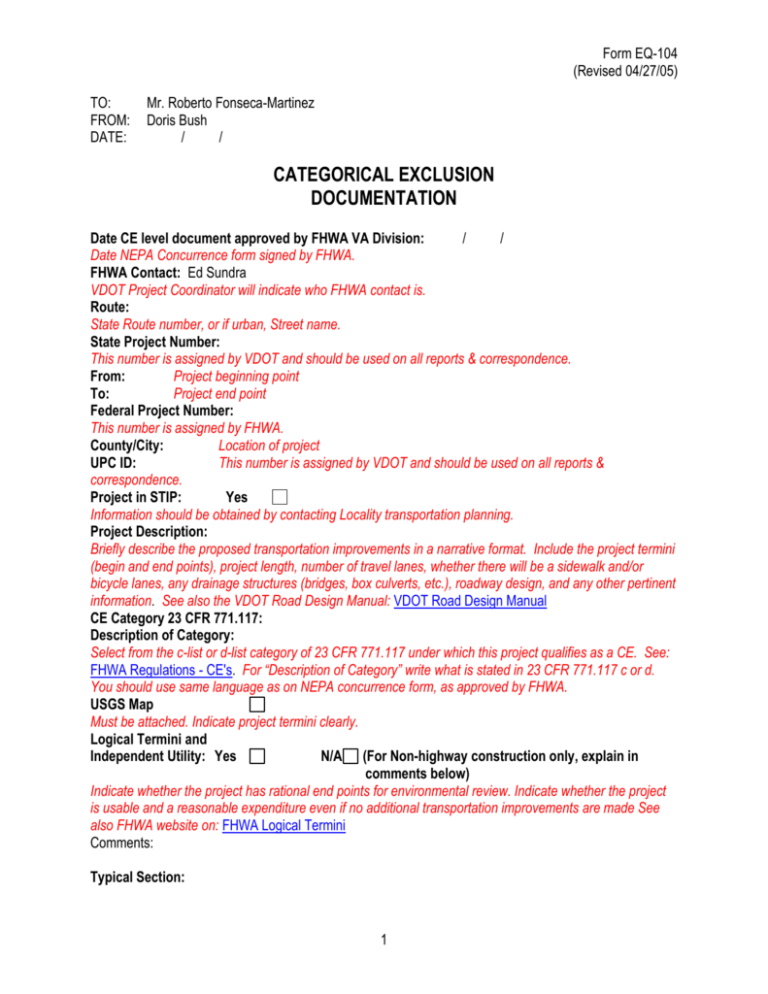
Form EQ-104 (Revised 04/27/05) TO: FROM: DATE: Mr. Roberto Fonseca-Martinez Doris Bush / / CATEGORICAL EXCLUSION DOCUMENTATION Date CE level document approved by FHWA VA Division: / / Date NEPA Concurrence form signed by FHWA. FHWA Contact: Ed Sundra VDOT Project Coordinator will indicate who FHWA contact is. Route: State Route number, or if urban, Street name. State Project Number: This number is assigned by VDOT and should be used on all reports & correspondence. From: Project beginning point To: Project end point Federal Project Number: This number is assigned by FHWA. County/City: Location of project UPC ID: This number is assigned by VDOT and should be used on all reports & correspondence. Project in STIP: Yes Information should be obtained by contacting Locality transportation planning. Project Description: Briefly describe the proposed transportation improvements in a narrative format. Include the project termini (begin and end points), project length, number of travel lanes, whether there will be a sidewalk and/or bicycle lanes, any drainage structures (bridges, box culverts, etc.), roadway design, and any other pertinent information. See also the VDOT Road Design Manual: VDOT Road Design Manual CE Category 23 CFR 771.117: Description of Category: Select from the c-list or d-list category of 23 CFR 771.117 under which this project qualifies as a CE. See: FHWA Regulations - CE's. For “Description of Category” write what is stated in 23 CFR 771.117 c or d. You should use same language as on NEPA concurrence form, as approved by FHWA. USGS Map Must be attached. Indicate project termini clearly. Logical Termini and Independent Utility: Yes N/A (For Non-highway construction only, explain in comments below) Indicate whether the project has rational end points for environmental review. Indicate whether the project is usable and a reasonable expenditure even if no additional transportation improvements are made See also FHWA website on: FHWA Logical Termini Comments: Typical Section: 1 Form EQ-104 (Revised 04/27/05) Describe the cross section of the improvement in detail. Include dimensions of ditches, sidewalks, curb and gutter, bicycle and pedestrian facilities, and medians. This section should describe the cross sections in greater detail than the Description section. See VDOT Road Design Manual Structures: Select the type of drainage structures, if any, required for the project. Drainage structures include bridges, box culverts, etc. If more than one is required, or detailed comments are needed, use the Description section. PRESENT IMPACTS YES NO YES NO SOCIO-ECONOMIC If a resource is present in the project area check the “Yes” box in the “Present” column. If it is not present, check “No.” If “No” is checked in the “Present” field, check “No” in the “Impacts” field.” If “Yes” is checked in the “Present” field, use the below guidelines to determine if an impact exists. If any box is checked “Yes,” an explanation should be included in the subsequent “Comments” section. See: Environmental Justice guidance Minority/Low Income Populations Using FHWA’s guidelines on environmental justice, determine if minority populations or populations below the poverty level are located within the project area. If they are, determine if the project will have a direct or indirect impact upon them. See: Environmental Justice guidance Disproportionate Impacts to Minority/Low Income Populations: Yes No If “Yes” has been checked in both boxes above, use the FHWA’s guidelines on environmental justice to determine if the project has a disproportionate impact on the minority or low-income community. If “No” has been checked in either of the above boxes, check “No” in this field. See: Environmental Justice guidance Existing or Planned Public Recreational Facilities Determine if existing or planned public parks, recreation areas, wildlife or waterfowl refuges are present in the project area. If they are present in the area, indicate if they will be impacted by the project. Source: Identify and document where information on recreational facilities has been obtained. Community Services Determine if schools, bus routes, fire and police stations, churches or other community facilities and services exist in the area, or are dependent upon the facility. Consider indirect impacts such as access in addition to direct impacts when filling in the “Impacts” field. See: Community Services Source: Identify and document where information on community services has been obtained. Consistent with Local Land Use: Yes No The locality’s planning staff should provide this information. Look at Comprehensive Plan. Source: Identify and document where information on land use has been obtained. Comments: This field is used to describe any findings or data that is not adequately addressed in the above Socioeconomic Table. If “Yes” has been checked in the “Present” or “Impacts” fields, a brief discussion must be included here. The discussion should include a description of why a resource that is present is not impacted, or why impacts are not considered significant. (for definition of “significant” see: "significant impacts" overview and FHWA discussion of Significance 2 Form EQ-104 (Revised 04/27/05) YES SECTION 4(f) and SECTION 6(f) Use of 4(f) Property: FHWA must determine if resource is 4(f) Acres: Indicate whether property protected under Section 4(f) is used by the project. Include the number of acres of right of way used by the project. If “Yes” is checked, one or more of the following fields must also be checked. See FHWA 4f reg's and FHWA guidance & policy Individually Eligible Historic Property: Indicate if the 4(f) use is from a property individually eligible for the National Register of Historic Places. Note: to determine if a resource is eligible for the National Register, you must have a determination from the Virginia Department of Historic Resources (State Historic Preservation Office). Contributing Element to Historic District: Indicate if the 4(f) use is from a property that is a contributing element to a Historic District on or eligible for the National Register. This would also be obtained from the Virginia Department of Historic Resources. Source: Identify and document where information has been obtained. Public Recreation Area: Indicate if the 4(f) use is from a property that is publicly owned and open to the public. The agency with jurisdiction over the area must be contacted to obtain a significance determination. Public Park: Indicate if the 4(f) use is from a property that is publicly owned and open to the public. The agency with jurisdiction must be contacted to obtain a significance determination. See FHWA 4f reg's and FHWA guidance & policy. Public Wildlife/Waterfowl Refuge: Indicate if the 4(f) use is from a publicly owned Wildlife or Waterfowl Refuge. The agency with jurisdiction must be contacted to obtain a significance determination. See FHWA 4f reg's and FHWA guidance & policy. Planned Public Park, Recreation Area, Wildlife or Waterfowl Refuge: Determine if planned public parks, recreation areas, wildlife or waterfowl refuges are present in the project area. If they are present, indicate if they will be impacted by the project. See: Section 4(f) guidance Source: Identify and document where information has been obtained. Constructive Use: If there is no permanent incorporation or adverse temporary occupancy a 4(f) property, but there is a constructive use, check “Yes”. See: FHWA 4f policy paper Section 4(f) Evaluation Attached: If any boxes in this section are checked “Yes”, the “Yes” box in this field must be checked and the 4(f) evaluation form attached. 3 NO Form EQ-104 (Revised 04/27/05) Conversion of 6(f) Property: Indicate if any parks in the project area were developed with funds from the Land & Water Conservation Fund Act by checking “Yes”. The park itself can tell you if 6(f) funds were utilized. If “Yes” is checked an explanation should be included in the subsequent “Comments” section. Acres: Comments: This field is used to describe any findings or data that are not adequately addressed in the above Section 4(f) and 6(f) fields. If “Yes” is checked in any of the above fields, it must be briefly described in this section. COMPLETE CULTURAL RESOURCES N/A This is Section 106 of the National Historic Preservation Act Advisory Council - 106 summary. Indicate the status of the following studies. If the Virginia Department of Historic Resources has approved the study, check “Complete.” If a particular study was not required, check “N/A.” See: VDHR Section 106 coordination Source: Identify and document where information has been obtained. "No Effect" Pursuant to 1999 DHR Agreement Not applicable to local government Phase I Architecture Conducted Phase II Architecture Conducted Phase I Archaeology Conducted Phase II Archaeology Conducted Effect on Historic Properties: No Effect From this drop down menu, choose the effect the project will have on historic properties. See: Section 106 Summary. You must coordinate with VDHR to answer this question before completing this form. DHR Concurrence on Effect: Yes Indicate whether DHR has concurred with the above effect determination. You must have DHR’s comments in writing. MOA Attached: Yes N/A Indicate whether a Memorandum of Agreement, pursuant to Section 106, is attached. If a MOA is required, but has not been executed, check “Pending.” If a MOA is not required, check “N/A.” If you must prepare a MOA, please coordinate also with the Advisory Council on Historic Preservation and VDOT for their comments. See: Advisory Council users guide and Resolving Adverse Effects Comments: This field is used to indicate the name of the historic property affected, if any, and a brief description of the resource. This field should be limited to information that describes why impacts to historic properties are not significant. 4 Form EQ-104 (Revised 04/27/05) PRESENT YES NO NATURAL RESOURCES If a resource is present in the project area check the “Yes” box in the “Present” column. If it is not, check “No”. If “No” is checked in the “Present” field, check “No” in the “Impacts” field”. If “Yes” is checked in the “Present” field, use the following guidelines to determine in an impact exists. If any box is checked “Yes”, an explanation should be included in the subsequent “Comments” section. Surface Water (Name: ) Check “Yes” in the “Present” column if any surface water is in the project area and enter the name of the body of water in the text field. If an impact will occur to the surface water, indicate the approximate linear feet of impact. Source: Identify and document where information has been obtained. Federal Threatened or Endangered Species: Using the drop down lists below, show which species may be in the project area as a result of the Virginia Department of Game and Inland Fisheries database search (information provided from State Environmental Review Process “Preliminary Environmental Inventory” and coordination with the Virginia Department of Conservation and Recreation. Indicate in the “Impact” column if the species will be impacted by the project. See: T & E guidance; DGIF - VA Fish & Wildlife Information; VA Dept of Ag - Endangered Species Terrestrial: None Aquatic: None Plants: None Source: Identify and document where information has been obtained. 100 Year Floodplain: If "Yes" then identify the regulatory floodway zone: Indicate if there is a floodplain in the project area and whether the project will impact it. If the project impacts a regulatory floodway zone, identify the appropriate code. See: FHWA Guidance - Floodplains Source: Identify and document where information has been obtained. Wetlands: If yes, there are no practicable alternatives to the construction in wetlands and the action will include all practicable measures to minimize harm to the impacted wetlands. Indicate if wetlands are present in the project area. If wetlands will be impacted, enter the approximate number of acres that will be impacted and the wetland type. See: FHWA Guidance - Wetlands Source: Identify and document where information has been obtained. Permits Required: If yes, the project may qualify for NW #23 Indicate if water quality permits will be required. Compensatory Mitigation Required: Indicate if the project impacts will require compensatory mitigation for wetland and/or stream impacts. Source: Identify and document where information has been obtained. 5 IMPACTS YES NO Linear ft. Acres NoneType Form EQ-104 (Revised 04/27/05) Comments: This field is used to describe any findings or data that are not adequately addressed in the above natural resource fields. This field should be limited to information that describes why project impacts are not significant. Present YES NO AGRICULTURAL/OPEN SPACE IMPACTS YES NO Open Space Easements Indicate whether there are any Va. Outdoor Foundation open space easements in the project area. If the project will require the acquisition of any property within the easement check “Yes” in the “Impacts” field. If any box is checked “Yes,” an explanation should be included in the subsequent “Comments” section. See: VA Outdoors Foundation - offices Source: Identify and document where information has been obtained. Agricultural/Forestal Districts County Board of Supervisors creates districts. Source: Identify and document where information has been obtained. Comments: This field is used to describe any findings or data that are not adequately addressed in the above Agricultural/Open Space fields. This field should be limited to information that describes why project impacts are not significant. If the project requires acquisition of an open space easement or Ag/Forestal District, the status of the conversion should be included. Present YES NO FARMLANDS NRCS Form CPA-106 Attached: Rating: The Natural Resource Conservation Service form CPA-106 should be attached unless the project has a density of 30 or more structures per 40 acres. If the form has been sent, the rating from NRCS should be included. See: VA NRCS; Form CPA-106; FHWA guidance on Farmland Act Alternatives Analysis Required: If the project receives a rating greater than 160 on the CPA-106, an alternatives analysis is required. If Form CPA-106 is not attached check all that are applicable: Land already in Urban use: Entire project in area not zoned agriculture: NRCS did not respond within 45 days: Source: Identify and document where information has been obtained. Comments: This field is used to describe any findings or data that are not adequately addressed in the above Agricultural/Open Space fields. This field should be limited to information that describes why project 6 Form EQ-104 (Revised 04/27/05) impacts are not significant. If the project requires acquisition of an open space easement or Ag/Forestal District, the status of the conversion should be included. YES INVASIVE SPECIES Present NO UNKNOWN Invasive Species in the project area: VDCR indicated that the potential exists for some VDOT projects to further the establishment of invasive species. All seeds used will be tested in accordance with the Virginia Seed Law to ensure that there are not Prohibited Noxious Weed-Seeds in our seed mixes. See: Invasive Species information Comments: This field is used to describe any findings or data that are not adequately addressed in the above Invasive Species fields. This field should be limited to information that describes why project impacts are not significant. YES AIR QUALITY See: FHWA, VDOT - Project Level Air Studies Agreement. Air Analysis Required: If "No", indicate which exemption it falls under: Exempt Project – According to 40 CFR 93.126 (table 2 exempt project), the project is identified as being exempt from air quality analysis. Since the project is exempt from an air quality analysis, it can be concluded that the project will not significantly impact air quality nor will it cause or contribute to an exceedance of the National Ambient Air Quality Standard for carbon monoxide. LOS Criteria – All of the intersections/interchanges in the project area or directly affected by the project are forecasted to operate at a level of service (LOS) of "C" or better in the design year. According to 40 CFR 93.123, only a qualitative analysis must be conducted for this project, therefore, it can be reasonably concluded that this project will not significantly impact air quality nor will it cause or contribute to an exceedance of the National Ambient Air Quality Standard for carbon monoxide. Traffic Volume – The project does not include or directly affect any roadway whose design year daily traffic volume would exceed the traffic thresholds outlined in the Memorandum of Understanding (MOU) between VDOT and FHWA for streamlining the project-level air quality analysis process. Modeling using "worst" case parameters has been conducted for these thresholds and it has been determined that projects below these thresholds, such as this one, would not significantly impact air quality nor will it cause or contribute to an exceedance of the National Ambient Air Quality Standards for carbon monoxide. Air Analysis Attached: Source: Identify and document where information has been obtained. Maintenance or Non-Attainment Area: See: FHWA Guidance on Air Quality on maintenance or non-attainment areas. 7 NO Form EQ-104 (Revised 04/27/05) In Long Range Plan & TIP: Information should be obtained by contacting locality planning office Source: Identify and document where information has been obtained. Comments: This field is used to describe any findings or data that are not adequately addressed in the above fields. This field should be limited to information that describes why project impacts are not significant. YES NOISE NO Type I Project: If the project is on new location, requires changes to the existing alignment, or increases the number of through lanes, check “Yes”. Consultation with VDOT’s Project Coordinator should occur. FHWA Guidance - Noise Source: Identify and document where information has been obtained. Noise Analysis Attached: Barriers Under Consideration: Source: Identify and document where information has been obtained. Comments: This field is used to describe any findings or data that are not adequately addressed in the above fields. This field should be limited to information that describes why project impacts are not significant. YES RIGHT OF WAY AND RELOCATIONS Residential Relocations: If “Yes”, number: Source: Identify and document where information has been obtained. Commercial Relocations: If “Yes”, number: Source: Identify and document where information has been obtained. Non-profit Relocations: If “Yes”, number: Source: Identify and document where information has been obtained. Right of Way required: Include the number of acres that will be acquired as fee simple right of way. See: FHWA Real Estate Acquisition Guide If “Yes”, acreage amount: Source: Identify and document where information has been obtained. 8 NO Form EQ-104 (Revised 04/27/05) PRESENT YES NO IMPACTS YES NO Septic Systems or Public Water Supplies: Indicate if public water supplies, wells, or septic systems are located in the project area by checking the appropriate box in the “Present” column. If these are present, indicate if they will be impacted by checking the appropriate box in the “Impacts” column. If any box is checked “Yes” an explanation should be included in the subsequent “Comments” section. Source: Identify and document where information has been obtained. Hazardous Materials: Indicate if hazardous materials are located in proximity to the construction limits by checking the appropriate box in the “Present” column. Check yes in the impacts column if hazardous materials are known to be in the construction limits. See: FHWA Guidance on Haz Mat Source: Identify and document where information has been obtained. Comments: This field is used to describe any findings or data that are not adequately addressed in the above fields. This field should be limited to information that describes why project impacts are not significant. CUMULATIVE AND INDIRECT IMPACTS YES Present NO N/A Present or reasonably foreseeable future projects (highway and nonhighway) in the area: Impact same resources as the proposed highway project (i.e. cumulative impacts): Indirect (Secondary) impacts: These impacts are caused by the action and are later in time or farther removed in distance, but still reasonably foreseeable. Indirect effects may include growth inducing effects and other effects related to induced changes in the pattern of land use, population density or growth rate, and related effects on air and water and other natural systems, including ecosystems. See: FHWA guidance on Cumulative and Indirect Impacts Source: Identify and document where information has been obtained. Comments: See: Impacts discussion. Comprehensive Plans must be checked for present or “reasonably” foreseeable (projects that have been approved by Board of Supervisors) projects. 9 Form EQ-104 (Revised 04/27/05) YES PUBLIC INVOLVEMENT NO Substantial Controversy on Environmental Grounds: Source: Identify and document agency contact where information was obtained. Public Hearing: If “Yes”, type of hearing: None Other Public Involvement Activities: If “Yes”, type of Involvement: Comments: in the above fields. This field is used to describe any findings or data that are not adequately addressed COORDINATION The following agencies were contacted during development of this study: Enter the names of all local, state, and federal agencies contacted during development of this study. Do not include VDOT This project meets the criteria for a Categorical Exclusion pursuant to 40 CFR 1508.4 and 23 CFR 771.117 and will not result in significant impacts to the human or natural environment. 10
