Convergent Plate Margins, Subduction Zones, and
advertisement
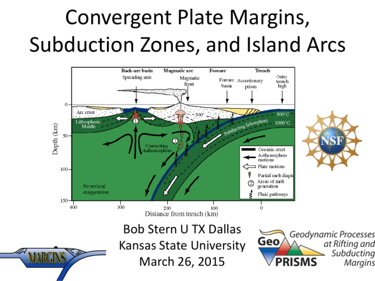
Convergent Plate Margins, Subduction Zones, and Island Arcs Bob Stern U TX Dallas Kansas State University March 26, 2015 GeoPRISMS Geodynamic Processes at RIfting and Subducting MarginS NSF-funded initiative – please look at NSF program anouncement Please go to GeoPRISMS.org for info about meetings etc. 2 main initiatives: Rift Initiation & Evolution (RIE) Subduction Cycles & Deformation (SCD) 3 sites: Alaska-Aleutian, Cascadia, New Zealand Structure of this Talk • Convergent plate margin, subduction zone, and arc-trench system definitions. • How upper and lower plates control arctrench system behavior. • How do we study subduction zones? • Seismogenic Zone • Arc magmas A Few Definitions Convergent Plate Margin, Subduction Zone, and Arc-Trench System Convergent Plate Margin: 2-D (surficial) plate boundary that is geometrically required for Plate Tectonic theory. Subduction Zone: 3-D region defined by asymmetric sinking of lithosphere into the mantle. Defined by earthquakes at depths <670 km and can be traced deeper with seismic tomography. Subduction Zones are not required but implied by Plate Tectonics. Arc-trench system: bathymetric and crustal expression of tectonic and magmatic processes above a subduction zone sometimes called “island arc”, “magmatic arc”, or just “arc”. Of these 3 related items, only Arcs are likely to be recognized in the geologic record. Convergent Plate Margins 55,000 km of subduction zones and continental collision zones Boxes show GeoPRISMS SCD focus sites Convergent Plate Margins are geometric requirements of Euler theorem = surficial features, like Divergent and Conservative Plate Boundaries No information in Plate Tectonic theory about how plates are destroyed. In fact, the process of destroying lithosphere requires a third dimension (subduction zone), ot required by other two plate boundaries. Subduction zone Mantle wedge slab Region in Earth’s upper mantle defined by sinking of oceanic lithosphere and associated processes (earthquakes, metamorphism, fluid release, induced convection, and melt generation). Entirely subsurface and hidden from view. The process of destroying lithosphere in a subduction zone also creates the crust of an Arc-Trench system* *preserved in geologic record; used to infer past presence of convergent plate margin and subduction zone A few notes about Arc-Trench systems 1. Importance of the overlying plate 1. Importance of the subducting plate 2. Why arc-trench systems around the Eastern Pacific (the Americas) are so different from those in the Western Pacific Eastern Pacific (Andes) Western Pacific (near Japan) 1. The nature of the crust on the overriding plate exerts strong controls on the nature of the arc-trench system (ATS) ATS on continental crust: Arc Volcanoes and inner forearc above sealevel ATS on oceanic crust: Only tops of tallest volcanoes are above sealevel Andean-type arcs have volcanoes that rise high above sealevel Llullaillaco (Argentina-Chile Andes) 6,739 m Last erupted 1877 Paranal Observatory (2635m) Llullaillaco 200 km away Volcanoes in Oceanic Arcs are often submarine NW-Rota 1 Submarine volcano Summit is 517 m below sealevel Started erupting sometime before 2003, quit erupting sometime between 2010 and 2014 Ongoing: MESH expedition to Kermadec Arc • Mapping, Exploration, and Sampling at Havre • From March 27 to April 17 2015, an international team will use remotely operated vehicle Jason and the autonomous underwater vehicle Sentry to investigate the largest recorded submarine explosive eruption in history • Follow blog: Google “MESH Havre volcano” IODP 350, 351, 352 Study the origin and evolution of the Izu-Bonin Arc March-Sept. 2014 Japan JOIDES Resolution 2. Importance of Subducting Plate The buoyancy* of the downgoing plate also exerts a strong influence on the tectonics and magmatism of arcs. *determined by age of downgoing plate and thickness of crust. Uyeda & Kanamori, 1979 Very buoyant downgoing crust results in Subduction Zone failure = continental collision. 3. Map of seafloor age reveals why W. Pacific and E. Pacific arcs are very different Müller et al., 1997 JGR-B Old, dense: subduct readily Young, buoyant: Resist subduction Müller et al., 1997 JGR-B Subduction of young, buoyant seafloor can result in overall compression, forming a reararc fold-and-thrust belt. Examples: Argentine Precordillera, Laramide orogen of USA Chracteristic of Eastern Pacific convergent margins Subduction of old, dense seafloor results in strong extension leading to seafloor spreading the formation of a backarc basin. Common in Western Pacific Subduction Zone Earthquakes define the Wadati-Benioff* Zone Most earthquakes are limited to upper 20 km of Earth, but subduction zone earthquakes are as deep as 670km! Why? Subducted slabs are cold. Cold things are brittle and break (making earthquakes), hot things bend and flow (no earthquakes) Shallow (<50km), Intermediate (50-250 km) and Deep (>250 km) subduction zone earthquakes have different causes. Kiyoo Wadati and Hugo Benioff are Japanese and US geophysicists who independently discovered deep, inclined seismic zones. Mariana Subduction Zone Seismicity Imaging of the mantle wedge using Subduction Zone earthquakes Thanks to Geoff Abers From subduction zone From other side of Earth Tomography gives volume-averaged properties; Other methods resolve layering Seismic tomography and seismicity in and above the Tonga subduction zone ∆ Vp Zhao et al. 1997 Mariana Arc-trench-backarc basin system Mantle tomography and magmagenesis Barklage et al. 2015 The Seismogenic Zone: The subduction interface 20-50km deep beneath the forearc The Seismogenic Zone Seismogenic Zone The deadliest, most powerful earthquakes occur in subduction zones at depths of ~20-50 km (12-30 miles) The Seismogenic Zone is especially dangerous because these are thrusttype earthquakes, near the surface, and beneath coastal areas. These are the earthquakes that generate most tsunamis. The 13 biggest Earthquakes (blue stars, with Magnitude) Earthquake magnitudes 8.5 to 9.5 All are instrumentally recorded events except the Cascadia EQ of 1700. All of these “monster quakes” happened in the seismogenic zone. Yellow dots are EQs of all mechanism bigger than ~Mw 5. Orange triangles are active volcanoes. Blue lines are plate boundaries. Interseismic interval (years) 1&4 Seismic interval (seconds) 2&3 The Earthquake cycle in the Seismogenic Zone: 1) Plate convergence is continuous but the two plates are locked across the shallow plate interface. This causes compression and uplift of the overlying plate margin (forearc). 2) Strain builds up until it exceeds the strength of the fault; the locked zone breaks and a great earthquake occurs. 3) During rupture, built-up strain is released, allowing the upper plate to relax. Subsidence & horizontal extension occurs in regions that were uplifted & compressed previously. 4) Cycle starts over modified from http://gsc.nrcan.gc.ca/geodyn/eqcycle_e.php Concept of earthquake epicenter is misleading in a quake this big; in fact a very large region ruptured, outlined by the dashed box. NY Times 2011 Tohoku Earthquake (Mw = 9.0) 1999 Interpretation Kodaira et al. 2011 Let’s get igneous! Anatahan 5-10-03 Mantles of silicate planets generate basalt Too much basalt Fe-free basalt Loads of basalt Basalt: 50 wt. % SiO2 10% CaO, 15% Al2O3; rest is mostly MgO and FeO. biggest basalt volcano in solar system Lots of basalt Asteroid Vesta4 diameter ~525 km Lots of basalt Earth’s mantle produces basalt at 3 tectonic settings: Mid-ocean ridges, hotspots, and arcs Convergent margin basalts differ most importantly in their MUCH GREATER abundance of magmatic water. In order to understand how arc magmas are generated, need to understand composition of downgoing lithosphere, oceanic crust, and sediments (slab) What causes melting to generate arc magmas? Why is the magmatic arc found ~105 km above subducted slab? H (= vertical distance from slab to volcanic front) ranges from 72 to 173 km with a mean of 105 km Syracuse et al., 2006 The Downgoing Plate Recall composition of subducting plate: How does this contribute to the generation of arc magmas? Subducted slab chills shallow mantle beneath forearc and draws in hot asthenosphere at greater depth (induced convection) Central America 105 km is “turning radius” of asthenospheric mantle. Addition of slab-derived fluids cause it to melt. Follow temperatures at 3 places on subducted plate Western Pacific Subduction Zone 105 km Sediments melt Eastern Pacific Subduction Zone The base of the mantle wedge above the subducted slab is transformed by fluids released from the slab Top: Receiver function seismic reflectivity profile beneath NE Japan (inset). Red and blue colors correspond to velocity increase and decrease with depth, respectively. Bottom: Interpretation on top of the reflectivity profile. Red triangles indicate active and dormant volcanoes. Kawakatsu et al. 2007 At ~105 km depth, there is a huge temperature gradient across slab interface ∆T ~800°C in 20 km Athenosphere NE Japan Metamorphosed Oceanic crust Greenstone: seafloor basalt metamorphosed in Greenschist facies: minerals contain ~5 wt. % water (<20 km deep). …is metamorphosed to… Blueschist: seafloor basalt metamorphosed in Blueschist facies. Minerals contain ~ 2 wt. % water (2060 km deep). …is metamorphosed to …. Eclogite: composed of 2 minerals Napyroxene (omphacite) and garnet (almandine – pyrope). Minerals contain ~0 wt. % water (>60 km deep). Water budget beneath NE Japan arc (Honshu) Schematic cross section of NE Japan subduction zone and magmatic system. Water budget for the incoming plate is from van Keken et al. (2011). F: degree of partial melting. Inset Is % water residue in slab. J03: (Jarrard, 2003); P11 w s: (van Keken et al., 2011) with serpentine; P11 w/o s: (van Keken et al., 2011) without serpentine; NAM: nominally anhydrous minerals. Kimura & Nakajima, 2014. NE Japan Mantle wedge Phase transitions, melting, and ascent of melts in Japan subduction zone; B: isotherms (ºC), zones of fluids, supercritical liquid, and melts superposed on seismic tomography images of Nakajima et al. (2009). Srp, serpentine; Chl, chlorite; AmEc, amphibole eclogite; EpEc, epidote eclogite; Br, brucite; Bs, blueschist; Tc, talc. Dobretsov et al., 2015 Arc magmas have much greater range in SiO2 content relative to hotspot and Mid-ocean ridge basalt (MORB) magmas 2 kinds of Convergent Plate Margins: Andean-type and Intra-Oceanic Arc (IOA) Systems Aka “island arc” Arc magmas have multiple opportunities to evolve in the crust Why so much felsic vocanics in arcs (and continental rifts) Location of ancient magmatic arcs is revealed by linear plutons = batholiths Batholith rocks of Western US formed as an Andean arc above the subducting Farallon plate in Jurassic and Cretaceous time KS Granodiorite, typical convergent margin plutonic rock. Late Mesozoic batholith of Western U.S. Granodiorite pluton Yosemite Falls, Yosemite National Park All volcanic rocks have been removed, exposing plutonic rocks at depth We are open and welcome participation. Please attend GeoPRISMS sessions, workshops, and meetings. Please go to GeoPRISMS.org to learn more!
