This Guide Includes:
1) Maps of Los Angeles (San Pedro) port with 54 tourist attractions, 2) Maps of downtown Long Beach
and cruise port, 3) Details on travel between LAX airport and the cruise ports, and 4) Information on
renting a car at LAX, a hotel in Long Beach, car drop off in Long Beach, and a taxi to the cruise port.
There are two ports ~ 25 miles from Los Angeles Airport (LAX):
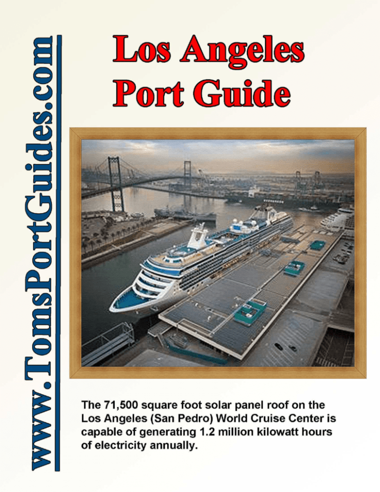
1. San Pedro is a port neighborhood within the city of Los Angeles and home for the Port of Los Angeles
World Cruise Center. This is the major cruise port used by all
cruise lines except Carnival. The USS Iowa battleship is docked
near the terminal. Enter the port gate at the intersection of W 1st
St and Harbor Blvd near the battleship; drive toward it, and turn
left to your cruise ship.
2. Carnival Corporation's Long Beach Cruise Terminal is in Long
Beach next to the RMSS Queen Mary. Follow road signs to the
Queen Mary to find your cruise ship. The Carnival terminal is
used exclusively by Carnival ships, but I did see one Princess
ship on the schedule.
I've written this guide assuming that you are arriving at the Los Angeles
International Airport (LAX) a day or two before your cruise, that you
need a hotel, will rent a car at the airport, and drop it off near the cruise
port. We flew from Philadelphia to Los Angeles three days before our Panama Canal cruise, rented a car from
Avis with unlimited mileage, booked a hotel in Long Beach, and spent our time exploring the area. We spent a
day driving through Joshua Tree National Park. This guide documents our experience with information to help
you to plan your trip. I highly recommend spending a few days in California before your cruise because there
are many wonderful places to visit = a perfect location for a mini-vacation.
The guide begins with detailed maps showing the location of the cruise ports with GPS coordinates so you can
find the port on Google maps and plot your travel route, distance, and time. I recommend Long Beach as a
place to book a hotel. It's close to the cruise terminals and is a wonderful city.
Before your rent a car at the airport, check the options to drop the car off near the cruise port. I've included tips
on how to find rental agencies with drop off locations near the port.
You probably need a taxi to the cruise port. I have included information to estimate the cost of your taxi.
There are many places to visit on your mini-vacation, consider driving through Joshua Tree National Park.
Table of Contents
Los Angeles area map showing the Los Angeles airport and cruise ports
Map showing details of Los Angeles (San Pedro) and Long Beach cruise terminals
GPS coordinates for the cruise ports
Los Angeles (San Pedro) 54 points of interest
Long Beach cruise port details
Consider a hotel in Long Beach
Dropping off an Avis airport rental car in Long Beach
Estimating taxi fares in the Los Angeles area
Los Angeles airport – finding a rental car company with drop off near the cruise ports
Spend a day touring Joshua Tree National Park in your rental car
User Feedback, Copyright Notice, Terms and Conditions for use of Toms Port Guides
2
3
4
5-6
7
7-9
10
11
12-13
14-19
20
CAVEAT
Information contained herein is believed to be accurate. PLEASE verify the information you use for your travel
plans. Opinions expressed are my own. This port guide is protected by copyright law - see the last page of this
guide for legal notices.
Tom Sheridan
LosAngeles-01-30-2014
Page 1 of 20
For more guides, see www.TomsPortGuides.com
Los Angeles International Airport & Cruise Terminals in San Pedro and Long Beach (Google terrain map)
It's 20.4 miles from the [A] Airport to [B] World Cruise Center in San Pedro and another 6.8 miles to [C] Carnival Cruise Terminal in Long Beach.
LosAngeles-01-30-2014
Page 2 of 20
For more guides, see www.TomsPortGuides.com
Los Angeles (San Pedro) World Cruise Center & Long Beach Carnival Cruise Terminal (Google terrain map)
LosAngeles-01-30-2014
Page 3 of 20
For more guides, see www.TomsPortGuides.com
GPS Coordinates
Google and Bing maps use unique street addresses to locate every building on public and private roads in the
US. Marine Ports don't have street addresses in the conventional sense. Dock locations are defined using
obscure terms such as “93 Berth, San Pedro, California 90731” or the “World Cruise Center.” This terminology
is not easily recognized by Google maps. Google can't find the location or often points to the wrong location.
To the extent possible, I use GPS coordinates in my port guides. GPS can pinpoint locations that don't have a
street address such as a dock or terminal building inside a port, ruins of an ancient site in a field, an island, a
location on the water, etc. GPS coordinates define a unique location on earth regardless of whether or not it has
a street address. Using GPS coordinates, I can specify the precise, unique location for every building, dock, etc.
in a port with an accuracy of about 50 ft., and Google will accurately display that location on a map.
Google maps display GPS coordinates as a down-pointing green arrow and a street address as a red balloon. If
the GPS coordinates and a street address exist for the same location, the red balloon is displayed on top of, and
hiding, the down-pointing green arrow. A large space between the green arrow and red balloon means there is
NO street address near that set of GPS coordinates. Bing maps display GPS coordinates as a blue dot.
This guide includes GPS Coordinates for tourist sites and key locations. Open this guide in one window on
your computer and open Google Maps in a second window. Copy and paste the GPS coordinates into Google
maps to find sites, get directions, and time for travel by car, bus, walking, or bicycle. The coordinates can be
used with any Google map format such as “map”, “satellite”, “earth”, and “terrain” to see detailed views of the
location at any map scale.
These coordinates can also be used in hand-held or vehicle GPS devices. Note that these devices can accept
different formats. It's important to set your device to accept data in this format:
Degrees, Minutes, and Seconds shown as N ddd° mm' ss.ss”, W ddd° mm' ss.ss”
GPS Coordinates Used in this Port Guide
Site
GPS Coordinates
Los Angeles International Airport (LAX)
N 33° 56' 32.89", W 118° 24' 29.06"
Avis Car Rental at Los Angeles International Airport (LAX)
9217 Airport Blvd, Los Angeles, CA
N 33° 57' 8.73", W 118° 23' 9.26"
Los Angeles (San Pedro) World Cruise Center
93 Berth, San Pedro, California 90731
N 33° 44' 50.07", W 118° 16' 37.03"
Los Angeles (San Pedro) Port Entrance Gate
W 1 st St at N Harbor Blvd
N 33° 44' 35.82", W 118° 16' 46.79"
USS Iowa Battleship
N 33°44′31.4″, W 118°16′38.6″
Long Beach Carnival Cruise Terminal
N 33° 45' 4.61", W 118° 11' 19.53"
RMSS Queen Mary
N 33° 45' 10.27", W 118° 11' 23.25"
Hyatt Regency Long Beach
N 33° 45' 48.63", W 118° 11' 29.14"
Avis Car Rental – Downtown Long Beach
249 E Ocean Blvd, Long Beach
N 33° 46' 1.68", W 118° 11' 24.41"
Los Angeles (San Pedro) World Cruise Center GPS = N 33° 44' 50.07", W 118° 16' 37.03"
For information on the port, car parking, etc. see http://www.sanpedro.com/spcom/crusshp.htm
USS IOWA Battleship GPS = N 33°44′31.4″, W 118°16′38.6″
http://www.pacificbattleship.com/
The Battleship IOWA is open daily from 10:00am to 5:00pm. Adult tickets are $ 18 online.
LosAngeles-01-30-2014
Page 4 of 20
For more guides, see www.TomsPortGuides.com
Los Angeles (San Pedro) World Cruise Center (Google map below)
Los Angeles Port has 54 Points of Interest (see map on next page)...
1. The Original Wienerschnitzel Restaurant
2. Saint John’s Episcopal Church
3. Saints Peter and Paul Catholic Church
4. Banning Residence Museum
5. Wilmington Cemetery
6. Drum Barracks Powder Magazine
7. Drum Barracks Civil War Museum
8. Banning Park Wrigley Historic District
9. Camphor Trees
10. Memory Chapel, Calvary Presbyterian Church
11. Old Wilmington Library
12. Masonic Lodge No. 198
13. Wilmington Waterfront Park
14. Banning’s Landing Community Center/Phineas
Banning Bronze Statue
15. Vincent Thomas Bridge
16. Catalina Sea and Air Terminal
17. Gateway Plaza Fanfare Fountains and Water
Feature/World Cruise Center
18. Port of Los Angeles Waterfront Red Car Line
19. Multiculturalism Statue
20. USS IOWA Battleship
21. Fireboat Ralph J. Scott/Fire Station 112
22. Los Angeles Port Police Headquarters
23. Port of Los Angeles Administration Building
24. Liberty Hill
25. John S. Gibson Park Memorials
26. Downtown Harbor (Under construction)
27. Warner Grand Theater
LosAngeles-01-30-2014
28. Historic Downtown San Pedro
29. San Pedro City Hall
30. Los Angeles Fire Department Museum
31. Los Angeles Maritime Museum
32. Ports O’Call Village
33. Vinegar Hill Historic District
34. U.S. Post Office, San Pedro
35. Muller House Museum
36. Timm’s Point/Timms Landing
37. CRAFTED at the Port of Los Angeles
38. 22nd St. Park
39. Cabrillo Way Marina
40. Japanese American Fishing Village Memorial
41. Municipal Warehouse No. 1
42. Cabrillo Marina
43. S.S. Lane Victory (Victory Ship)
44. Cabrillo Fishing Pier
45. Angels Gate Lighthouse (No pedestrian access)
46. World-Famous Whale Watching Tours and Premier
Sportfishing
47. Cabrillo Beach Bathhouse & Outer Cabrillo Beach
48. Juan Rodriguez Cabrillo Statue
49. Cabrillo Marine Aquarium & Inner Cabrillo Beach
50. Stephen M. White Statue
51. Point Fermin Lighthouse
52. Korean Bell/Angels Gate Cultural Center
53. Fort MacArthur Military Museum/Battery Osgood Farley
54. Cirque du Soleil Totem – October 11 thru November 10
Page 5 of 20
For more guides, see www.TomsPortGuides.com
Download this Map & Brochure at http://www.portoflosangeles.org/pdf/map_points_of_interest.pdf
There is an old fashioned red trolley, “Waterfront Red Car Line” that runs 1.5 miles along Harbor Blvd, past the
port gate, from point 18 to point 36 as shown on the map above. The trolley ride is $ 1.
LosAngeles-01-30-2014
Page 6 of 20
For more guides, see www.TomsPortGuides.com
Long Beach Carnival Cruise Terminal
Need a Hotel near the Cruise Ports? Consider Downtown Long Beach.
We booked a Coral Princess cruise in December 2012 from Los Angeles World Cruise Center to Ft Lauderdale
via Panama Canal. We flew from Philadelphia to Los Angeles International Airport (LAX), rented a car at Avis
for three days, dropped the car off in Long Beach, and took a taxi to Los Angeles World Cruise Center.
We selected Hyatt Regency Long Beach for our hotel. Downtown Long Beach is an upscale, clean, attractive
area with several shops and hotels. There are many excellent restaurants along Ocean Blvd, Long Beach Blvd,
W. Shoreline Dr, etc. The Convention-Entertainment Center and Arena are next to the Hyatt Regency. There's a
“Convention Center Walkway” and pedestrian bridge from the hotel across W. Shoreline Dr to the harbor, the
Aquarium of the Pacific, and a cluster of restaurants including P. F. Chang, Outback Steakhouse, Famous
Dave's, Tokyo Wako, Chili's, Boston's the Gourmet Pizza, Bubba Gump Shrimp Co., etc.
Hotel Information from the Tourist Office http://www.visitlongbeach.com/stay/
There’s nothing like state-of-the-art accommodations. Long Beach offers a dazzling selection of new and
recently renovated rooms — perfectly appointed, ideally located, and refreshingly affordable. In fact, every
major downtown and Long Beach Airport hotel is virtually brand new, thanks to $105 million in recent
renovations. Long Beach offers more than 5,000 rooms citywide, most within walking distance of conference
facilities, entertainment and dining. Wherever you need to be, Long Beach can accommodate you.
LosAngeles-01-30-2014
Page 7 of 20
For more guides, see www.TomsPortGuides.com
Long Beach Waterfront is where the action begins
and the fun never ends. From the regal Queen Mary
and spectacular Aquarium of the Pacific to stirring
Broadway shows, live music venues and hundreds of
exclusive dining destinations--all centrally located.
Airport-close, a brief and pleasant cruise away from
Catalina Island and a short distance from Disneyland,
Universal Studios Hollywood and everything Southern
California has to offer--Long Beach is the perfect
destination!
See http://www.visitlongbeach.com/ for information on
tourist sites, things to see & do, etc.
Hyatt Regency Long Beach
GPS = N 33° 45' 48.63", W 118° 11' 29.14"
200 S Pine Ave Long Beach, CA 90802
http://longbeach.hyatt.com/en/hotel/home.html
I was impressed with the Hyatt Regency. Our room
was spacious and well-appointed on the 10 th floor
overlooking the Queen Mary.
The hotel was
conveniently located near the harbor, shops,
restaurants, and tourist attractions. We could walk to
many places downtown or use our rental car, parked
($ 18/day) in the garage next to the hotel.
Long Beach Carnival Cruise Terminal GPS = N 33° 45' 4.61", W 118° 11' 19.53"
http://www.sanpedro.com/spcom/crusshp2.htm
231 Windsor Way, Long Beach, CA 90802 Google maps show this street address next to the cruise terminal.
Contact Name: Wilkin Mes Title: MGR, Long Beach Cruise Terminal Phone: (562) 901-3232
Website: http://www.carnivalcorp.com
The cruise terminal is an unusual domeshaped white building. It was originally
built to display the “Spruce Goose”,
Howard Hughes' airplane. Later, it was
used as a movie production studio for one
of the Batman films. Eventually, it was
bought by Carnival Cruise Line.
RMSS Queen Mary
GPS = N 33° 45' 10.27", W 118° 11' 23.25"
http://www.queenmary.com/
RMSS Queen Mary is next to the Carnival
Cruise Terminal (Google aerial photo at
right).
The Queen Mary is a hotel. You can book
a stateroom or suite, or you can stop by to
enjoy the restaurants, shopping, tours, and
a variety of events and activities.
LosAngeles-01-30-2014
Page 8 of 20
For more guides, see www.TomsPortGuides.com
Scenic Downtown Long Beach (Google aerial photos)
LosAngeles-01-30-2014
Page 9 of 20
For more guides, see www.TomsPortGuides.com
Dropping the Rental Car Off at Avis Downtown Long Beach
Avis ICB Building (International City Bank) - Downtown Long Beach
249 East Ocean Boulevard #104, Long Beach, CA 90802, GPS = N 33° 46' 1.68", W 118° 11' 24.41"
http://locations.avis.com/ca/long-beach/lb5.html?IATA=0105965L
There is no parking along E. Ocean Blvd in this area, so I turned right on N Waite Ct and stopped at the red
asterisk shown on the Google aerial photo below. I dropped off our luggage at the Avis rental counter and
drove around the block entering the parking garage on Long Beach Blvd as shown by red arrows on the map.
The lady at Avis called a cab which arrived in a few minutes. The driver had only been driving a taxi for a few
days. He had no idea where the World Cruise Terminal was and would not move the cab until he programmed
the destination into his GPS device. I gave him the GPS coordinates but he did not know how to program GPS
coordinates into his device. He only knew how to program street addresses. We ended up in a parking lot past
the ship, turned around, and drove to the ship. Fortunately, cruise ships are big and easy to see from a distance.
Estimating Taxi Fares in the Los Angeles Area
There are several websites that estimate taxi fares. I use http://www.taxifarefinder.com/main.php?city=LA
The pop-up ads are a distraction, but the website provides a lot of useful information. To use the site, you'll
need “From” and “To” addresses that can be recognized by Google Maps.
•
For the Avis Car Rental in Downtown Long Beach, you can use either the street address of “249 E
Ocean Blvd, Long Beach, CA 90802” or the GPS coordinates of N 33° 46' 1.68", W 118° 11' 24.41"
•
For the Los Angeles (San Pedro) World Cruise Center, you MUST USE GPS coordinates of
N 33° 44' 50.07", W 118° 16' 37.03" The word-based port address will NOT work in this website; the
website will calculate a taxi fare and draw a map to the WRONG location!
LosAngeles-01-30-2014
Page 10 of 20
For more guides, see www.TomsPortGuides.com
Estimated Taxi Fare
FROM 249 E Ocean Blvd, Long Beach, CA 90802
TO
N 33° 44' 50.07", W 118° 16' 37.03"
The route map shown above is accurate because I used GPS coordinates for the cruise ship dock. It's a 6.6 mile,
11 minute ride. The estimated fare based on light traffic is $ 24.77 + 15% tip = $ 28.49. I paid $ 30. In heavy
traffic, the base fare would be about $ 35.51 + 15% tip = $ 40.84.
Estimating Taxi Fares Between the Los Angeles Airport and the World Cruise Center
Enter “Los Angeles International Airport” into the website http://www.taxifarefinder.com/main.php?city=LA
and the website will fill in the full address. Be sure to use the GPS coordinates for the World Cruise Center.
This is the information you'll need in the website.
From: Los Angeles International Airport, 1 World Way, Los Angeles, CA 90045, USA
To:
N 33° 44' 50.07", W 118° 16' 37.03"
It's a 20.5 mile, 25 minute ride. There is a $ 4 taxi surcharge at the airport.
The cost for a taxi ride in light traffic is $ 66.80 + 15% tip = $ 76.82.
In heavy traffic, the taxi fare is $ 79.33 + 15% tip = $ 91.23.
Note: Airport and freeway traffic is always heavy.
LosAngeles-01-30-2014
Page 11 of 20
For more guides, see www.TomsPortGuides.com
Los Angeles International Airport (LAX)
GPS = N 33° 56' 32.89", W 118° 24' 29.06"
Los Angeles International Airport, 1 World Way, Los Angeles, CA 90045, USA
Los Angles (LAX), Ontario (ONT), & Van Nuys (VNY) airport website = http://www.lawa.org/
Download PDF maps for the LAX main terminal, individual terminals, parking areas, etc. from
http://www.lawa.org/welcome_lax.aspx?id=256
This website has a map for each of the terminals plus a map showing the stops for buses, etc, near all the
terminals. The map below is the main terminal layout.
Finding Car Rental Agencies Near Your Cruise Ship Dock
There are many car rentals at the airports with shuttle buses to/from the terminals. However, there are a limited
number of car rentals close to cruise ship docks. How do you find the car rental companies near your cruise
ship so you can rent a car with that agency at the airport and drop the car off near the ship?
Google Maps have some slick search capabilities.
Google recognizes the word “near” in the search box. This allows you to search for car rentals near the
cruise port if you enter the specific address for the World Cruise Center using its GPS coordinates. See the map
on the next page.
LosAngeles-01-30-2014
Page 12 of 20
For more guides, see www.TomsPortGuides.com
Enter this string in the address line box in Google Maps
Car Rental near N 33° 44' 50.07", W 118° 16' 37.03"
Google Displays the Map Below Showing Nine Car Rentals Within Six Miles of the World Cruise Center
NOTE: Car rental companies often change the location of their offices. Go to the national website for the car rental company to verify the street
address you are using is a valid, current car rental location for that company.
Check the rental agency website to determine if there is a drop-off fee. The Enterprise website lists a $ 40 fee to drop the car off at 235 W 6 th St, San
Pedro, shown as point [A] on the map. I rented a car from Avis at the Los Angeles airport and dropped it off, with NO drop-off fee, at Avis in
Downtown Long Beach, shown as 249 E Ocean Blvd, Long beach, point [D] on the map.
LosAngeles-01-30-2014
Page 13 of 20
For more guides, see www.TomsPortGuides.com
Joshua Tree National Park
http://www.nps.gov/jotr/index.htm
It's a beautiful park showcasing the diverse geology and ecosystems of “high” and “low” deserts. There are
scenic views of mountain ranges, granite rock formations, dry creek beds, trees, cactus, etc. You can view the
park and take photos from your car, but you'll get better photos by stopping at road pull-offs and walking a short
distance, on level pathways, to explore the area. Below is a brief summary of our drive through the park. For
complete details, see my Joshua Tree California National Park Rental Car Driving Tour Guide. It's a
companion document to this port guide.
The best time to visit the park is mid-October to mid-April because temperatures are comfortable. It can be 90
to 100 F in the summer. If you're interested in flowers, go in mid-April when wildflowers are in bloom.
Plan on a minimum of 3 hours in the park and a full day excursion to/from the Los Angeles area.
The park is 140 miles and a 2 hour and 20 minute drive from either Long Beach or Los Angeles. Plan on a
minimum of 3 to 4 hours in the park. With 3-4 hours in the park and 5 hours driving to/from the park, it's a full
day, but well worth it.
Joshua Tree National Park is 794,000 acres or 1,234 sq miles (3,196 km²) with two deserts:
• The western half of the park is the “high” Mojave Desert with rugged mountains, exposed granite
monoliths, and the famous Joshua Tree. According to legend, Mormon pioneers thought the trees
resembled up-stretched arms of Joshua leading them to the promised land.
•
The eastern half of the park is a “low” desert with an elevation below 3,000 feet (910 m). It's the
Colorado Desert, part of the Sonoran Desert. As you come down from the “high” desert to the “low”
desert watch for “alluvia fans”, the fan-shaped deposits of water-transported material at the base of the
mountains. You'll also see vegetation-free flat areas, dry creek beds, creosote bush, and small stands of
spidery ocotillo and cholla cactus.
The park is open all Yyar; 8 am to 5 pm Admission $ 5/person or $15 for a vehicle with up to 7 people.
Download a shaded relief map from http://www.nps.gov/jotr/planyourvisit/upload/jotrmap.pdf
Download a brochure from http://www.nps.gov/jotr/planyourvisit/upload/2012guide.pdf
The map below shows our driving route through the park A-B-C-D
We exited the park onto westbound interstate 10.
LosAngeles-01-30-2014
Page 14 of 20
For more guides, see www.TomsPortGuides.com
Driving Through Joshua Tree National Park
We entered the park at Joshua Tree Visitor Center in the “high”, Mojave Desert, drove through the mountains
stopping to walk around and photograph many granite monoliths, Joshua Trees, the “Keys View” overlook of
San Andeas Fault and mountains, and skull rock. Then we drove to the “low” Colorado Desert and stopped to
walk around the Cholla Cactus Garden and exited the park at Cottonwood Visitor Center.
Location
GPS Coordinates
[A] Joshua Tree Visitor Center
6554 Park Boulevard, Joshua Tree, CA
N 34° 8' 3.39", W 116° 18' 54.47"
[B] Keys View of San Andreas Fault and Mountains
N 33° 55' 35.00", W 116° 11' 15.25"
[C] Skull Rock
N 33° 59' 52.97", W 116° 3' 34.98"
[D] Cholla Cactus Garden
N 33° 55' 31.36", W 115° 55' 44.73"
[E] Cottonwood Visitor Center
N 33° 44' 55.16", W 115° 49' 26.76"
Safe Driving in the Park
Park roads, even the paved roads, are narrow, winding, and have soft, sandy shoulders. Accidents occur when
visitors stop along the road to admire a view or take a picture. There are many pullouts and parking lots. Please
wait until you get to one before stopping. (Message from the Park Service)
From Joshua Tree Visitor Center, you enter the “high”, Mojave Desert which is home to the undisciplined
Joshua tree. There are extensive stands throughout the western half of the park. Photo above
LosAngeles-01-30-2014
Page 15 of 20
For more guides, see www.TomsPortGuides.com
[B] Keys View
GPS = N 33° 55' 35.00", W 116° 11' 15.25"
Keys View is a “must visit” area. It's on the edge of the mountain in the park looking down into the valley,
across San Andreas Fault Zone to the Santa Rosa Mountains. There is a large parking lot at Keys View with a
paved, short walking trail to see different panoramic views, all of which are beautiful. Photo below
LosAngeles-01-30-2014
Page 16 of 20
For more guides, see www.TomsPortGuides.com
[C] Skull Rock
GPS = N 33° 59' 52.28", W 116° 3' 35.15"
The park encompasses some of the most
interesting geologic displays found in California’s
deserts. Rugged mountains of twisted rock and
exposed granite monoliths testify to the
tremendous earth forces that shaped and formed
this land.
Apparently, one of the many jobs of the geologists
and park rangers is to name the different rock
formations. This rock is appropriately named
“Skull Rock”. (Photo right)
It sure looks like a skull to me. Across the street
from Skull Rock is a formation that looks like
fingers of a giant hand reaching out of the ground.
If you're traveling with children or if you're
“young at heart”, you can have fun naming the
rock formations.
The “Low” Colorado Desert (Photo Below) GPS = N 33° 55' 58.88", W 115° 57' 35.12"
LosAngeles-01-30-2014
Page 17 of 20
For more guides, see www.TomsPortGuides.com
As you come down from the “high” Mojave Desert to the “low” Colorado Desert, watch for “alluvia fans”, the
fan-shaped deposits of water-transported, vegetation-free, material at the base of the mountains. You'll see other
vegetation-free flat areas, dry creek beds, creosote bush, and small stands of spidery ocotillo and cholla cactus.
The photo on the previous page shows the “alluvia fans”. To view this from a different perspective, enter the
GPS coordinates of N 33° 55' 58.88", W 115° 57' 35.12" into Google Maps, select “satellite” view, and adjust
magnification to your preference. This creates the image below. The down-pointing green arrow is the location
of the GPS coordinates where I took the photo on the previous page.
Google Satellite Image Showing the Tip of an Alluvia Fan at the Down-Pointing Green Arrow
When you have GPS coordinates for your photos, you can view the location from satellites to better appreciate
the geology of Joshua Tree National Park. This is a very impressive national park!
Cholla Cactus Garden
GPS = N 33° 55' 31.36", W 115° 55' 44.73"
The “low” desert is famous for cactus, so we had to stop at the Cholla Cactus Garden. I was surprised to read
this warning sign.
LosAngeles-01-30-2014
Page 18 of 20
For more guides, see www.TomsPortGuides.com
Photos of the Cactus
The road south of the cactus garden toward Cottonwood Visitor Center and Interstate 10 (photo below)
NOTE: This is a brief overview of our driving tour of the park showing a few stops and photos.
I have published a much more detailed summary with many more GPS coordinates and photos so you can
preview your drive, know what to look for, and where to stop along the way. In the detailed summary, I also
illustrate how to use Google Maps to preview your drive through the park to see every granite monolith, hill,
mountain, tree, plant, etc. along the route. To view the detailed summary, download the Joshua National Park
Scenic Driving Tour from my website. It's next to the listing for this Los Angeles Port Guide.
LosAngeles-01-30-2014
Page 19 of 20
For more guides, see www.TomsPortGuides.com
User Feedback Is Welcome
Goal
My guides are designed to help you plan a great cruise vacation by providing information such as where the
ship docks, location of tourist sites, public transit, walking tour maps, things to see and do, travel issues unique
to the port, etc. Knowledge of ports is important when planning shore excursions because you have to make
many decisions and commitments long before your ship docks. I believe the information in this guide is
accurate, however you are responsible to verify accuracy of the information that you use to plan your vacation.
Information on cruise ports frequently changes such as bus routes, admission fees to sites, rental car locations,
etc. Cruise Critic is the best source for up-to-date, detailed information on travel details for shore excursions,
reviews of cruise ships, etc. There are many knowledgeable people on Cruise Critic who are willing to share
their expertise and travel experience. I highly recommend www.CruiseCritic.com; it's free to join.
Why feedback is important
User feedback helps me make corrections and improve the format and content in my quest to produce the
“ultimate” port guides. I welcome offers to collaborate with me or provide materials for use in my guides.
PLEASE Help “spread the word” about my website
The only negative feedback I get is, “I wish I knew about your port guides before my vacation”. Please tell
your friends and post a reference to my guides and website on the blogs. To receive email notification when
new guides are available, send your email address to me at TomsPortGuides@gmail.com
Copyright Notice & Terms and Conditions for Use of My Guides
My port guides and everything on my website www.TomsPortGuides.com is copyrighted by Thomas Sheridan
with all rights reserved, and protected by international copyright laws.
PERMITTED USE: Personal, non-commercial use of my port guides and/or material from my website.
I allow individuals to take my guides apart for personal, non-commercial use. Many cruisers carry a map or a
few pages from my guide on a shore excursion. That's OK. I also allow people to post my guides on websites
they set up for fellow travelers to share information on shore excursions such as the websites set up by Cruise
Critic members for the Roll Calls. That's OK. My guides are for use and enjoyment of individual travelers.
PROHIBITED USE of my port guides and/or material from my website.
NO person, company, organization, website, etc. is permitted to use material from my website for a commercial
purpose, to sell, require a membership to download my port guides, or use my copyrighted material for a
commercial purpose.
NO person, company, organization, website, etc. is permitted to distribute excerpts from my guides or material
from my website as electronic, digital, or paper copies. My Port Guides must be kept intact, as downloaded
from my website, with this copyright notice.
NO Cruise Ship employee, representative, contractor, port lecturer, etc. is permitted to distribute excerpts from
my guides or material from my website as electronic, digital or paper copies. My Port Guides must be kept
intact, as downloaded from my website, with this copyright notice. A blatant example of violation of my
copyright was a cruise ship docked in Copenhagen where the shore excursion desk personnel removed maps
from my guide, removed my name as the copyright owner, and copied/distributed my maps.
Fortunately, a friend of mine on that ship complained to the purser and the ship stopped violating my copyright.
If there is any question about use of my guides, contact me at TomsPortGuides@Gmail.com
Tom Sheridan
LosAngeles-01-30-2014
Page 20 of 20
For more guides, see www.TomsPortGuides.com

