The Black Sea I: Geography
advertisement
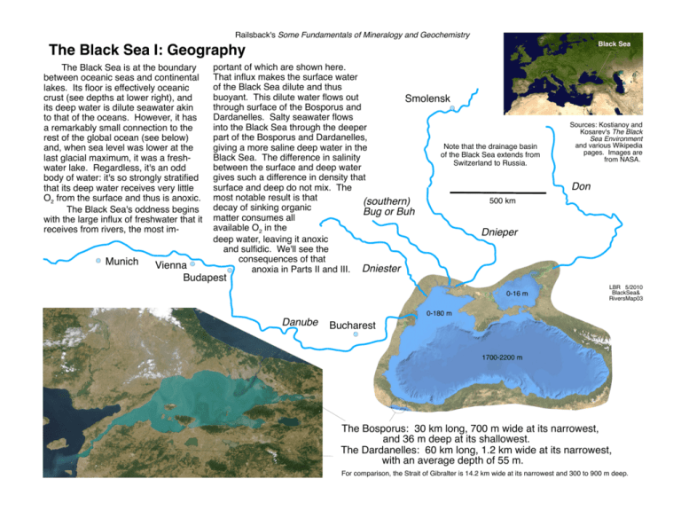
Railsback's Some Fundamentals of Mineralogy and Geochemistry Black Sea The Black Sea I: Geography The Black Sea is at the boundary between oceanic seas and continental lakes. Its floor is effectively oceanic crust (see depths at lower right), and its deep water is dilute seawater akin to that of the oceans. However, it has a remarkably small connection to the rest of the global ocean (see below) and, when sea level was lower at the last glacial maximum, it was a freshwater lake. Regardless, it's an odd body of water: it's so strongly stratified that its deep water receives very little O2 from the surface and thus is anoxic. The Black Sea's oddness begins with the large influx of freshwater that it receives from rivers, the most im- Munich portant of which are shown here. That influx makes the surface water of the Black Sea dilute and thus buoyant. This dilute water flows out Smolensk through surface of the Bosporus and Dardanelles. Salty seawater flows into the Black Sea through the deeper part of the Bosporus and Dardanelles, Note that the drainage basin giving a more saline deep water in the of the Black Sea extends from Black Sea. The difference in salinity Switzerland to Russia. between the surface and deep water gives such a difference in density that surface and deep do not mix. The most notable result is that 500 km (southern) decay of sinking organic Bug or Buh matter consumes all available O2 in the Dnieper deep water, leaving it anoxic and sulfidic. We'll see the consequences of that anoxia in Parts II and III. Dniester Sources: Kostianoy and Kosarev's The Black Sea Environment and various Wikipedia pages. Images are from NASA. Don Vienna Budapest 0-16 m LBR 5/2010 BlackSea& RiversMap03 0-180 m Danube Bucharest 1700-2200 m The Bosporus: 30 km long, 700 m wide at its narrowest, and 36 m deep at its shallowest. The Dardanelles: 60 km long, 1.2 km wide at its narrowest, with an average depth of 55 m. For comparison, the Strait of Gibralter is 14.2 km wide at its narrowest and 300 to 900 m deep.
