Mapping Exercise Summary and Guide
advertisement
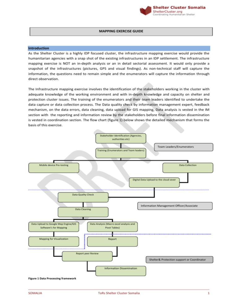
Shelter Cluster Somalia ShelterCluster.org Coordinating Humanitarian Shelter MAPPING EXERCISE GUIDE Introduction As the Shelter Cluster is a highly IDP focused cluster, the infrastructure mapping exercise would provide the humanitarian agencies with a snap shot of the existing infrastructures in an IDP settlement. The infrastructure mapping exercise is NOT an in-depth analysis or an in detail sectorial assessment. It would only provide a snapshot of the infrastructures (pictures, GPS and visual findings). As non-technical staff will capture the information, the questions need to remain simple and the enumerators will capture the information through direct observation. The Infrastructure mapping exercise involves the identification of the stakeholders working in the cluster with adequate knowledge of the working environment and with in-depth knowledge and capacity on shelter and protection cluster issues. The training of the enumerators and their team leaders identified to undertake the data capture or data collection process. The Data quality check by information management expert, feedback mechanism, on the data errors, data cleaning, data upload for GIS mapping, Data analysis is vested in the IM section with the reporting and information review by the stakeholders before final information dissemination is vested in coordination section. The flow chart (figure 1) below shows the detailed mechanism that forms the basis of this exercise. Stakeholder Identification (Agencies, authorities etc) Team Leaders/Enumerators Training (Enumerators and Team leaders) Mobile device Pre-testing Data Collection Digital Data Upload to the cloud sever Data Quality Check Information Management Officer/Associate Data Cleaning Data Upload to Google Map Engine/GIS Software’s for Mapping Data Analysis (Macro excel analysis and Pivot Tables) Mapping for Visualization Report Report peer Review Shelter& Protection support or Coordinator Information Dissemination Figure 1 Data Processing framework SOMALIA ToRs Shelter Cluster Somalia 1 Shelter Cluster Somalia ShelterCluster.org Coordinating Humanitarian Shelter Stakeholder Identification and Training The successful exercise requires proper engagement with the relevant authorities, agencies and the members of the community. The proper identification of these stakeholders is very important and it must be completed before any funds are committed. Once the stakeholders have been identified and the information is shared objectively, they are engaged in the identification and recruitment of the potential enumerators who will undertake the exercise through the digital platform. The enumerators and the team leaders are therefore trained in the use of the mobile data capture device, after which they are subjected to practical tests on data capture. The data is then uploaded to ensure that they have clearly understood the process. Upon satisfactory approval by the trainers, the enumerators are assigned working settlements by their team leaders within which they are collecting the data. Data Collection The data collection process entails the use of the mfieldwork tool, a digital platform designed for shelter and protection cluster data capture. The data collectors (enumerators) are assigned mobile phones equipped with the tool and required to undertake data collection as detailed in the data capture training manual. The enumerators in this stage are advised to upload the data they collected at the end of the first day so that the information management officer can implement the data quality check and give feedback on the data quality which may necessitate correction at field level or repeat of the data capture process in some cases where the data is not properly captured. Data Quality Checks and Cleaning The data quality check entails, a detailed review of some data entries that are very key in mapping and analysis. The GPS location of the settlement has to be confirmed as the information captured is referenced to a location. The settlement names, household numbers, age, facility errors such as those of latrine dropping holes etc, perimeter outlines, density points patterns, multiple choice and typed answers among others are they key areas that the information management officer base the quality checks on. In an event where the datasets passes the test, it is then taken to the next stage of analysis and uploaded to the Google maps engine or into a GIS platform for mapping and visualization purposes. Data Analysis and Mapping The data analysis tasks are performed by the IM officer using analysis tools such as excel macro among others to develop the algorithms that will enable the automation of the large volumes of data captured to be processed. The internal quality checks on the algorithms developed are checked by the IM officer to ensure that the formulas execute the options properly before the data is used to generate the pivot tables that will be used for reporting by the Shelter and Protection coordinators. The same cleaned data subjected for analysis is also uploaded to Google map engine or GIS software for visualization of facilities, key informant interview positions, densities and perimeter of the settlements. The uploaded information is then used to produce static and dynamic maps for reports and reference that can enable future tracking. Information Dissemination The information derived from the data is compiled and a report is made by the coordinators/support officer. The report is subjected to an internal peer review for errors and omission checks to ensure that the details intended to be reported are contained in the report. This report thereafter will be widely disseminated by the Shelter and Protection Coordinators to the relevant stakeholders (Governments, Agencies and Donors). SOMALIA ToRs Shelter Cluster Somalia 2 Shelter Cluster Somalia ShelterCluster.org Coordinating Humanitarian Shelter STEP BY STEP GUIDE TO THE MAPPING EXERCISE THE MOBILE APPLICATION FOR MAPPING The mobile application is very user friendly. Click on the “settlement mapping” questionnaire to find the infrastructure mapping exercise. Click on the questionnaire and the first thing it will do is ask you to capture the exact location through a GPS point (longitude, latitude). The next 4 questions will be general information regarding the exercise (which region/district/city/settlement). Then the questionnaire will ask you what organisation you are working for. The following questions will use skip logic depending on the choice that you make. The following choices have been made available. Meeting with community leader (always to be done first) Taking a perimeter point (always to be done first) Note: When mapping the perimeter, please when prompted by this question ’’is this exercise done at the same time as an in-depth questionnaire’’ please respond NO by selecting it. Capturing of density Capturing a latrine Capturing a water point Capturing a solar lighting post Capturing a kiosk Capturing a community centre Capturing a market Capturing a garbage collection point Capturing a police post Capturing a school Capturing a health facility After having made a choice, you will only receive specific information regarding that choice. For example, if you choose ‘capturing a school’, you will only be asked questions related to schools. At the end of all questionnaires, the phone will ask you to take a picture. Make sure that you stand far enough from the structure to get a good quality picture. METHODOLOGY FOR THE MAPPING EXERCISE PER SETTLEMENT The following methodology is recommended: Day 1 1. 2. SOMALIA Determine within the settlement, how many sub-settlements there are. Sometimes a bigger settlement is comprised of two separate settlements (no geographical distinction but difference in clan). You will have two separate community leaders. Separate the exercise for the different settlements. Finish one and continue afterwards with the second. Go over the secondary data that exists on the settlement (for example last registration data of last NFI/shelter distribution; last figures of Humanitarian Gap Analysis; REACH data,…). Spend half an hour discussing as a group what is known about the settlement. Make some rough notes on numbers and figures that exist already. ToRs Shelter Cluster Somalia 3 Shelter Cluster Somalia ShelterCluster.org Coordinating Humanitarian Shelter 3. a. b. c. d. e. f. 4. 5. 6. 7. 8. The group leader meets with the settlement leader to have a focus group discussion and he will go through the questions related to general information of the settlement (question A.6 What are you capturing: Discussion with settlement leader). If there are several settlement leaders and the camp is not split up into different settlements, choose only one. If the settlement is split up in two sub-settlements, have two separate meetings with the settlement leaders. Explain to the settlement leader what the purpose of this mapping exercise is. Make sure he answers the question to the best of his knowledge. Questions regarding the land ownership and clan dynamics: some of the questions are optional and can be skipped, as they could be considered too sensitive. Questions regarding dates: it will be easier to make it multiple-choice/single select (0/1/3/6/9/12/2years…) instead of asking a specific month. While the group leader is talking to the settlement leader the other enumerators go around the boundary of the settlement and capture a perimeter point every 80 steps (question A.6 What are you capturing: perimeter). For each point on the perimeter, you will alternately take a picture facing the settlement and one taken away from the settlement. Go back to the office and upload all the points. Look on the web platform of MFIELDWORK and look at the map where the settlement is located. Analyse the information that has been captured with the community leader and discuss the findings. Prepare the teams for the next day (groups per pair). The group leader will be following the enumerators and will monitor the quality of the exercise. Split the settlement into blocks. Use the natural divisions in the settlements (rivers, mains roads, main firebreaks ect). Each pair of enumerators will be assigned to a specific geographic area. Day 2 1. 2. 3. 4. 5. 6. SOMALIA Return to the same settlement that you captured the perimeter of yesterday. The group-leader matches the teams to their respective assigned section in order that everybody understands which section they should cover. The enumerators will start with the collection of density data (question A.6 What are you capturing: density). In the centre of their block, they will capture the location of 20 different households living all in one area (*NOTE* it is important that all 20 households be next to each other in the same section). This will provide us with a representative size and will provide information regarding the density of each different block. The enumerators should capture all the communal infrastructure points that exist in their block (question C/D/E/F/G/H/I/J). If there are four different latrines in your section it is important to capture ALL four. For each different sector (latrine, water point, school,…) a maximum of 10 questions will be asked. The enumerators will answer the questions mainly through direct observation and as little as possible through a discussion with the community. (question A.6 What are you capturing: Latrines, Water points, Schools, Medical clinic, Nutritional Centre, Police post, Market, Kiosk, Child Friendly Space). The enumerators should work in pairs (one person to work on the mobile application and one person to observe and discuss if necessary with the community/doctor/teacher/… Return to the office and upload all data from phones. ToRs Shelter Cluster Somalia 4 Shelter Cluster Somalia ShelterCluster.org Coordinating Humanitarian Shelter GOOD QUALITY PICTURES (good and bad examples) EXAMPLES (Good Photos) also available in the presentation -A good photo captures the whole infrastructure or as much as possible. EXAMPLES (Bad Photos) few details are captured here; also available in the presentation USE OF PHONE AND MFIELDWORK See manual for mFieldwork. GENERAL CHECKS BEFORE GOING TO THE FIELD If the agencies do not have a log in code, contact the Shelter Cluster Secretariat for access to the website. Make sure everyone is logged in with his phone on the MFIELDWORK application before leaving the WIFI area. It is necessary to be logged in when in the field. Once you start the mapping exercise turn WIFI off to save battery, as long as you are logged in to the application the data will still upload. Make sure the latest versions of all the questionnaires have been downloaded. Make sure that the GPS is functional on all the phones. Try this out at the office. Organise the team in pairs: one who will be discussing with the household and one who will be using the phone. Make sure all the phones are properly charged. TIPS DURING THE TRAINING SOMALIA Do a quick demo on the technology. It demystifies the technology. We will delete these entries later on. ToRs Shelter Cluster Somalia 5 Shelter Cluster Somalia ShelterCluster.org Coordinating Humanitarian Shelter SOMALIA Review the questionnaire on paper: Everyone can take notes and have the paper with them as reference. Identify changes needed to the form before data collection begins. Ensure everyone understands all questions the same way. Always ask for the latest version. Phone training: Demonstrate how to get the phone on the WiFi, how to log into the mobile application, how to upload records, and how to ensure the GPS is working. Office practical: Interview each other and do one record each with each tool. You should debrief during and after if they find questions that need changes or if clarification is required. Field practical: Go in to the field to collect 1 to 2 records each with each tool. Debrief afterwards by looking at the excel data column by column. Find any errors, places where they have questions, or changes needed to the tool. ToRs Shelter Cluster Somalia 6
