corporate office - Feel India Tours & Travels
advertisement
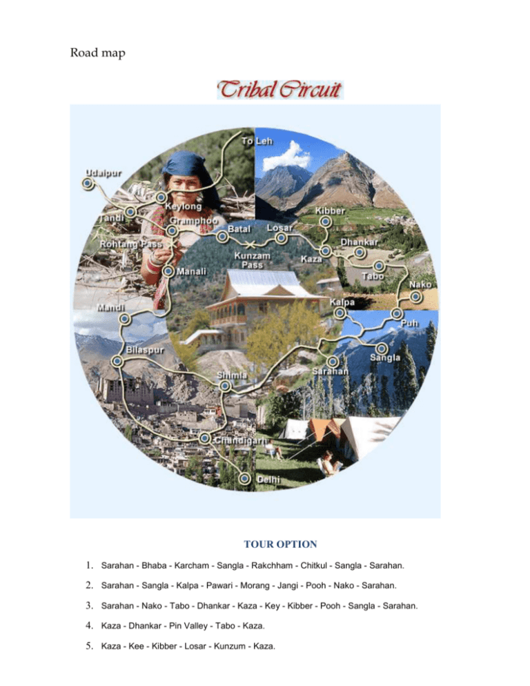
Road map TOUR OPTION 1. Sarahan - Bhaba - Karcham - Sangla - Rakchham - Chitkul - Sangla - Sarahan. 2. Sarahan - Sangla - Kalpa - Pawari - Morang - Jangi - Pooh - Nako - Sarahan. 3. Sarahan - Nako - Tabo - Dhankar - Kaza - Key - Kibber - Pooh - Sangla - Sarahan. 4. Kaza - Dhankar - Pin Valley - Tabo - Kaza. 5. Kaza - Kee - Kibber - Losar - Kunzum - Kaza. 6. Keylong - Udaipur - Triloknath - Kardang - Gondla - Keylong. 7. Keylong - Darcha - Patseo - Zingzingbar - Baralacha - Sarchu - Keylong. 8. Keylong - Sarchu- Lachalangla - Pang - Tanglangla - Uphsi - Leh - Keylong. Passing through a spectacular terrain of River Valleys, Cold Desert Mountains, High Passes, Snow Capped Peaks, Icy Lakes, Mighty Glaciers, an exotic tribal country dotted by monasteries, yaks and lamas. This circuit covers: Delhi - Shimla - Sarahan - Sangla - Kalpa - Nako - Tabo - Dhankar - Pin Vally - Kaza - Losar - Kunzum Koksar - Sissu - Tandi - Udaipur - Trilokpur - Rohtang Pass - Manali - Delhi. Kinnaur - the land of fairy tales and fantasies, has a spectacular terrain of lush green valley, orchards, vineyards, snow clad peaks and cold desert mountains. It is a border district of Himachal Pradesh. Kinnaur is also rich in flora & fauna. The culture and language is different from other parts of the state. Kinnaur, the tribal district of Himachal Pradesh, lies 250 km away from Shimla, the capital of Himachal Pradesh and is situated on the NH - 22 (Hindustan Tibet Road). The landscape of the area varies from lush green orchards of the scenic Sangla Valley to the stark magnificence of the Hangrang Valley. The massive snow clad ranges that provide a regal dignity to the scene are dominated by the peak of Kinner Kailash. Kalpa is one of the biggest and beautiful villages of Kinnaur. One can enter Kinnaur district at Village Chshora and follow a straight line road constructed in vertical rock and it is a rare treat to travel on this road which is a great engineering feat. Situated at the height of 2758 m above the sea level and 110 km from Sarahan, Kalpa is a beautiful and main village of Kinnaur. Across the river faces the majestic mountains of the Kinner Kailash range. These are spectacular sights early in the morning as the rising sun touches the snowy peaks with crimson and golden light. ACCESS: Nearest Airport (267 km) and Railhead (244 km) is at Shimla. The route is on NH - 22 (The Hindustan Tibet Road) which bifurcates to Kalpa from Powari. Buses and Taxis are available at Shimla and Rampur. One can also reach Kalpa via Manali - Rohtang Pass - Kunzam Pass - Kaza (400 km). CLIMATE: In winter, the temperature can drop to below freezing point when heavy woolens are required and for summers light woolens are recommended. THE KINNER KAILASH: The hotel is strategically located for visiting Kinnaur or traveling ahead to Spiti. This is a newly built hotel with all modern facilities. The design of the hotel has been inspired by the traditional architecture of the area. Needless to add, it has one of the finest views in the world. ADDRESS: The Kinner Kailash, Kalpa (H.P.) - 172108. Tel: (01786) - 226159. CLASS: Deluxe Hotel. Check availability & book The Kinner Kailask Rooms are modern, well furnished with attached baths and running hot & cold water. Restaurant serving Indian, Continental, Chinese and Himachali cuisine Satellite Television, Sprawling Lawn, Parking within premises. Closed from December - March due to extreme weather conditions PLACES OF INTEREST RECONG PEO (2670M): Located 240 km from Shimla, 7 km from Powari and 13 km from Kalpa. Recong Peo is the headquarter of district Kinnaur. KOTHI: Just 3 km from Recong Peo. Kothi has a temple dedicated to the goddess Chanadika Devi. Set against a backdrop of mountains and graves of the deodar the temple has an unusual architectural style and fine sculpture. An exquisite gold image of goddess is enshrined in sanctum. SANGLA VALLEY: If a landscape had the powers of casting spells, then the Sangla valley would be a magician extraordinary. Once seen, it is a place that can never be forgotten. Even the rushing waters of the Baspa river, that flow through its 95 km length, seem to absorb some of the magic and slow down to savor its snow-frame beauty. 2 km from Sangla is the fort of Kamru (300 m) its tower like architecture resembles that of the Bhima Kali complex and this was the origin of rulers of Bushehar. Chitkul (3450 m) is the last village of the valley and beyond lies Tibet. RIBA (2745M): Just 18 km from Powari on NH-22 is famous for its vineyards and local wine 'Angoori' made from grapes. JANGI: 26 km from Powari, the inner border is located here beyond which foreigners require permit to travel upto Tabo. From this point the famous Kinner Kailash Parikarama Trek starts touching Morang, Thangi and Kunocharang villages and entering Chitkul village in Sangla Valley. PUH (2837m): Lush green fields, orchards of apricot, almond trees and vineyards, are to be seen on route to Puh. Just 58 km from Powari along the NH-22, Puh has rest house and basic hotel facilities. NAKO (3662m): 117 km from Kalpa. In Hangrang Valley is the largest village above sea level. It is also famous for Nako Lake which has boating facilities in summer and during winter its frozen surface is used for ice skating. Buddhist monastery is located here. TABO (3050m): 163 km from Kalpa and 27 km from Sando the ancient village, Tabo is situated on the left bank of river Spiti. Flanked on either side by hills, it is one of the most important Buddhist monasteries regarded by many as only next to the Tholing Gompa in Tibet. It is also known as the Ajanta of the Himalayas. Tabo is the largest monastic complex of Spiti which has since been declared a protected monument under the Archaeological Survey of India. KAZA (3600m): 210 km from Kalpa 47 from Tabo. The headquarters of Spiti sub-district, Kaza is on the bank of river Spiti. In earlier times, it was the capital of Nono, the chief of Spiti. It has a Buddhist Monastery and Hindu Temple. KEY GOMPA (4116m): 7 km from Kaza. The largest monastery in Spiti Valley. Established in the 11th century, it has ancient Buddhist scrolls and paintings. Also houses the largest number of Buddhist monks and nuns. KIBBER (4205 m): 18 km from Kaza. The highest village in the world which is connected by a motorable road and also the highest village in the world which has its own polling station during elections. KUNZAM PASS (4551m): 76 km: One of the highest motorable passes. Goddess Kunjum keeps guard over the pass and wards of the evil. Situated at an altitude of 3600 meter above sea level on left bank of river Spiti is presently the headquarters of Spiti sub division. Translated, 'Spiti' means the 'middle country' - a name obviously given as a result of its ties with both India and Tibet. With freckles of green over a dry, weather-beaten face, Spiti is a cold desert where the monsoon rain never comes. It is characterised by stark beauty, narrow valleys and high mountains. A century ago, Rudyard Kipling in Kim called Spiti "a world within a world" and a "place where the gods live" a description that holds true to the present day. ACCESS: Nearest airports are at Kullu (Bhuntar) 250 km. and Shimla 445 km. Kaza can be approached by road from Shimla (May to October) and from Manali 200 km. via Kuzam Pass (June to October). CLIMATE: This region is known as Cold Desert and does not receive rainfall. In winter the temperature can drop below freezing point, when heavy woolens are required. In summers the weather remains pleasant when light woolens are advised THE SPITI: Named after the Spiti river and complimenting the Spiti valley, the hotel has been started recently. The hotel serves as excellent accommodation for exploring the artistically and culturally rich monastery's around Kaza ADDRESS: The Spiti, Kaza, Spiti - 172114. Tel.No: (01906) - 222752. CLASS: Deluxe Hotel. Note: The tariff for Double Bed Room is inclusive of Veg. Food Charges @ Rs. 400/- for 2 persons per day i.e. breakfast and lunch or dinner. Open June to October Rooms are modern with attached baths and running hot & cold water. Dormitory available Restaurant, Room service, Satellite Television Drive in, Parking within premises. Tariff on MAP plan THE TOURIST LODGE: Himachal Tourism runs four room Tourist Lodge at Kaza. ADDRESS: Tourist Lodge, Kaza, Spiti 172114. CLASS: Budget Hotel. Check availability and book The Tourist Lodge Note: The tariff for 4 Double Bed Rooms is inclusive of Veg. Food Charges @ Rs. 300/- for 2 persons per day i.e. breakfast and lunch or dinner. Drive in, Parking, Catering. (Open June to October) Spacious rooms having attached bath with running hot and cold water. PLACES OF INTEREST TABO: (3050 m) 163 km from Kalpa is the ancient village of Tabo, situated on the left bank of river Spiti. Flanked on either sides by hills, its has one of the most important Buddhist monasteries regarded by many as only next to the Tholing Gompa in Tibet. It is also known as the Ajanta of the Himalayas. Tabo is the largest monastic complex of Spiti which has since been declared a protected monument under the aegis of Archaeological Survey of India. KAZA: (3600m) 210 Km from Kalpa, 47 km from Tabo. The headquarters of Spiti sub-district, Kaza lies on the bank of river Spiti. In earlier times, it was the capital of Nono, the Chief of Spiti. It has a Buddhist Monastery and Hindu Temple. KEY GOMPA: (4116m) 7 km from Kaza. The largest monastery in Spiti Valley. Established in the 11th century has ancient Buddhist scrolls and paintings. It also houses large number of Buddhist monks and nuns. KIBBER: (4205m) 18 km from Kaza. The highest village in the world which is connected by motorable road and is the highest habitated village in the world which has its own polling station during elections. DHANKAR: (3890m) 24 km from Tabo, this place is famous for a Buddhist monastery. PIN VALLEY: The Pin valley lies below the Kungri Glacier and has several beautiful and important monasteries. iT is called the land of Ibex and snow leopards KUNZAM PASS: (4551m) 76 km. One of the highest motorable pass. Goddess Kunjum keeps guard over this pass and wards off evil. CHANDER TAL LAKE: (4270m) 7 km from Kunzam Pass, is one of the most beautiful lakes in the entire Himalayan region. Surrounded by snow, this deep blue water lake has a circumferences of 2.5 km. River Chandra flows very close to the lake. IMPORTANT INFORMATION FOR INDIAN AND FOREIGN TOURISTS The Kinnaur and Spiti area of Himachal Pradesh has been opened to Indian and Foreign tourists. While going via Shimla and Rampur - Kalpa, Recong Peo and Sangla Valley can be visited by Indians and Foreigners without any restrictions. To travel beyond Jangi in Kinnaur to Kaza in Spiti one requires an inner line permit for foreign nationals which can be obtained from the following offices: District Magistrate - Shimla, Recong Peo (Kinnaur), Kullu, Keylong (Lahaul) Sub District Magistrate (SDM) - Shimla, Rampur, Kalpa, Nichar, Keylong, Udaipur Additional Deputy Commissioner Office in Pooh and Kaza. The best place to get the permit is at Rampur and Recong Peo. The office of the SDM at Rampur is just opposite the Police Station in the main bazaar and the office of the District Magistrate at Recong Peo is near the bus station. The permit is free of cost and holds good for seven days. To get a permit, one must have a letter of introduction from a recognised travel agency, three passport size photos, and a photocopy of the front pages of the passport. Making several copies of the permit is suggested, as one may have to submit them at checkpoints on the way. Foreign nationals can travel with permits in a group of four or more persons. Foreign nationals cannot stay overnight between Jangi and Kaza. Indian nationals do not require any permit to travel in this area however retaining a proof of identity is suggested. Situated at an altitude of 3350 m, Keylong is the headquarters of Lahaul and Spiti district of Himachal Pradesh. The region is strange, exciting, primitive mountainous and delightful. Rudyard Kipling said of the region "Surely the God live here this no place for men." The route to Lahaul takes a traveler over Rohtang Pass (3980 ml), Koksar (1st village of Lahaul) Sissu, Gondla and crossing the river Chandra Bhaga at Tandi ACCESS: By road the distance is 115 km from Manali, 188 km from Kaza, 373 km from Leh, 435 km from Chandigarh and 690 km from Delhi. Heavy winter snows cut off road connectivity to the region at Rohtang Pass for six months from November to June. Buses, Taxis are available from Manali in season. HPTDC also plies regular coaches to Leh via Keylong during July - September. Nearest airport is Bhunter, 175 km from Keylong. CLIMATE: Lahaul remains cut-off from outside the world till mid June due to heavy snowfall and closing of Rohtang Pass. There is little or no rain in monsoons. The climate remains dry and invigorating. The days are hot and nights are extremely cold. Heavy / Light woolens are recommended. The Chander Bhaga, Kelyong: The majestically built hotel is on the Manali Leh road at Keylong, offering spectacular views of the Kardang monastery and the four high peaks covered with snow. The hotel serves as excellent accommodation for exploring the artistically and culturally rich monastery's in the vicinity of Keylong ADDRESS: The Chander Bhaga, Keylong, Distt. Lahaul & Spiti (H.P.) Tel: (01900) - 222247, 222393. CLASS: Budget Hotel. Check availability and book The Chander Bhaga Note: The traiffs for Family Suit and Double Bed Room are inclusive of Veg. food charges @ Rs. 800/- in family suite and Rs. 400/- in Double Bed Room per day. Open June to October Rooms are modern with attached baths and running hot & cold water. Dormitory available Restaurant, Room service, Satellite Television Parking within premises. Tariff for rooms is on MAP plan PLACES OF INTEREST TANDI (2573m): 8 km, short of Keylong, on the Manali - Leh Raod, situated on the confluence of Chandra & Bhaga rivers. Last point to tank up if traveling north of Keylong as it has the last fuel station on this stretch. SISSU (3100m): On the bank of Chandra, 15 km from Koksar, every spring and autumn wild geese and ducks halt here on their way to and from Siberia. GONDLA (3110m): 18 km from Keylong on the right bank of river Chandra. Famous for ancient Fort. UDAIPUR (2523m): 53 km from Keylong, home of the Mrikula Devi Temple, which is famous for wood carvings. TRILOKNATH (2660m): 4 km from Udaipur famous for Triloknath temple. Sacred both for HIndu and Buddhist. MONASTERY'S: Lahaul is well known for its monasteries, locally called Gompas, which are great repositories of Buddhist faith and art treasures. These are Kardang - 5 km, Shasur - 3 km, Guru Ghantal - 8 km, Tayul - 6 km, Gemur - 18 km SHOPPING: Shawls, Local Tweeds, Caps, Rugs, Footwear, Fresh fruit, Natural oil (olive and almond), Sliver jewellery, Pullovers, Metal craft, Woolen jackets and Bamboo products. Feel India Tours & Travels Pvt. Ltd. 111, Apollo Tower, 2 Mg Road, Indore - 452001 Ph : 0731-2526294, 4286622 E-mail: feelindiatour@gmail.com Website:www.feelindia.org CORPORATE OFFICE H.P.TOURISM DEVELOPMENT CORPORATION LIMITED RITZ ANNEXE, SHIMLA-171 001 Tel (0177)2652704 Fax (0177)2652206. You can check online availability before quoting and confirming www.hptdc.gov.in

![HP[KINNAUR, SPITI, LAHAUL] TOUR DRAFT - Team-BHP](http://s3.studylib.net/store/data/007478301_1-99bc5d6eecfba891c6108c658dc8f0df-300x300.png)
