Geology 101 - Jan Rasmussen.com
advertisement
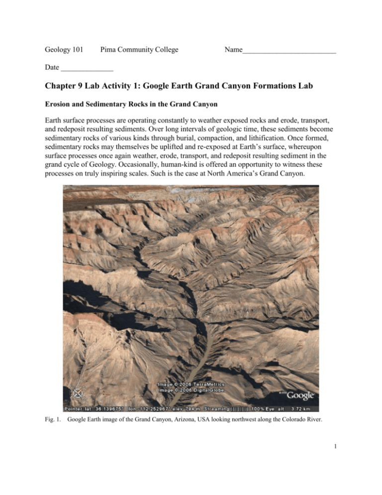
Geology 101 Pima Community College Name_________________________ Date ______________ Chapter 9 Lab Activity 1: Google Earth Grand Canyon Formations Lab Erosion and Sedimentary Rocks in the Grand Canyon Earth surface processes are operating constantly to weather exposed rocks and erode, transport, and redeposit resulting sediments. Over long intervals of geologic time, these sediments become sedimentary rocks of various kinds through burial, compaction, and lithification. Once formed, sedimentary rocks may themselves be uplifted and re-exposed at Earth’s surface, whereupon surface processes once again weather, erode, transport, and redeposit resulting sediment in the grand cycle of Geology. Occasionally, human-kind is offered an opportunity to witness these processes on truly inspiring scales. Such is the case at North America’s Grand Canyon. Fig. 1. Google Earth image of the Grand Canyon, Arizona, USA looking northwest along the Colorado River. 1 To begin your exploration of the Grand Canyon and its geology, enter coordinates from the table below which begins from the famous and historic El Tovar Hotel in Canyon Village. LOCATION LATITUDE LONGITUDE El Tovar Hotel 36.057308 -112.137652 1. Spend some time navigating around the Grand Canyon with Google Earth. http://www.google.com/earth/index.html 2. Zoom to the bottom of the canyon and note the detail of the imagery here where it is possible to view the legendary rapids along the Colorado River. 3. Once you have gained some familiarity with the canyon and its geography, read the Wikipedia entry on the Grand Canyon. Note especially the section detailing the geology of the Grand Canyon. The standard geologic column of the Grand Canyon is presented as a cross-section illustration below. 2 LEGEND 6d - Kaibab Limestone 6c - Toroweap Formation 6b - Coconino Sandstone 6a - Hermit Shale 5d - Esplanade Formation 5c - Wescogame Formation 5b - Manakacha Formation 5a - Watahomigi Formation 4c - Surprise Canyon Formation 4b - Redwall Limestone 4a - Temple Butte Limestone 3c - Muav Limestone 3b - Bright Angel Shale 3a - Tapeats Sandstone 2 - Grand Canyon Supergroup (Wedge Series) Fig. 2. 1b - Zoroaster Granite 1a - Vishnu Schist Geologic column of the Grand Canyon. Numbers in white refer to formation names on the left. Numbers in black refer to sections from the Wikipedia article on the Grand Canyon. 4. Enter the following coordinates in the Google Earth query bar (the blank box next to the magnifying glass): 36.152269 -112.317651 5. Using the top circle, move the N to the right to rotate the image so the view is looking west, then tilt the image (using the top circle up arrow or carat symbol) until you can see the canyon rim (i.e., the top edge of the canyon). Now, back away until you can just see the Colorado River in the bottom of the canyon. 6. Save this image to your disk using the ‘Save Image’ option under the ‘File’ menu. 3 7. Either print the image or open a new document using Microsoft Word. When the document opens, import the image using the ‘Insert’ menu and ‘Picture’ and ‘From file…’ options. 8. Compare your image to the illustration of the geologic column above (Fig. 2). Draw a line at the base and top of each major formation and write the formation name between the lines or use an arrow from the name to the formation. Or if you are familiar with Word and drawing tools, on the Word document use the text box and drawing tools in Microsoft Word to label your image with labels showing the geologic formations on your image. Return the labeled print to the instructor. You can also label the formations on one of the photographs on the website. Links to Related Sites: Wikipedia entry on the Grand Canyon: http://en.wikipedia.org/wiki/Grand_Canyon Wikipedia entry on the Grand Staircase: http://en.wikipedia.org/wiki/Grand_Staircase Wikipedia entry on Grand Canyon Geology: http://en.wikipedia.org/wiki/Geology_of_the_Grand_Canyon_area Geology of the Grand Canyon: http://www.kaibab.org/geology/gc_geol.htm Geology of the Grand Canyon: http://www2.nature.nps.gov/geology/parks/grca/ National Park Service web site: http://www.nps.gov/grca/index.htm Stratigraphy of Grand Canyon: http://3dparks.wr.usgs.gov/coloradoplateau/grandcanyon_strat.htm Generalized Geologic Time Scale: http://3dparks.wr.usgs.gov/coloradoplateau/timescale.htm Colorado Plateau Geology: http://www2.nature.nps.gov/geology/education/foos/plateau.pdf 4
