Hazard and Vulnerability Data for St. Vincent and the Grenadines
advertisement
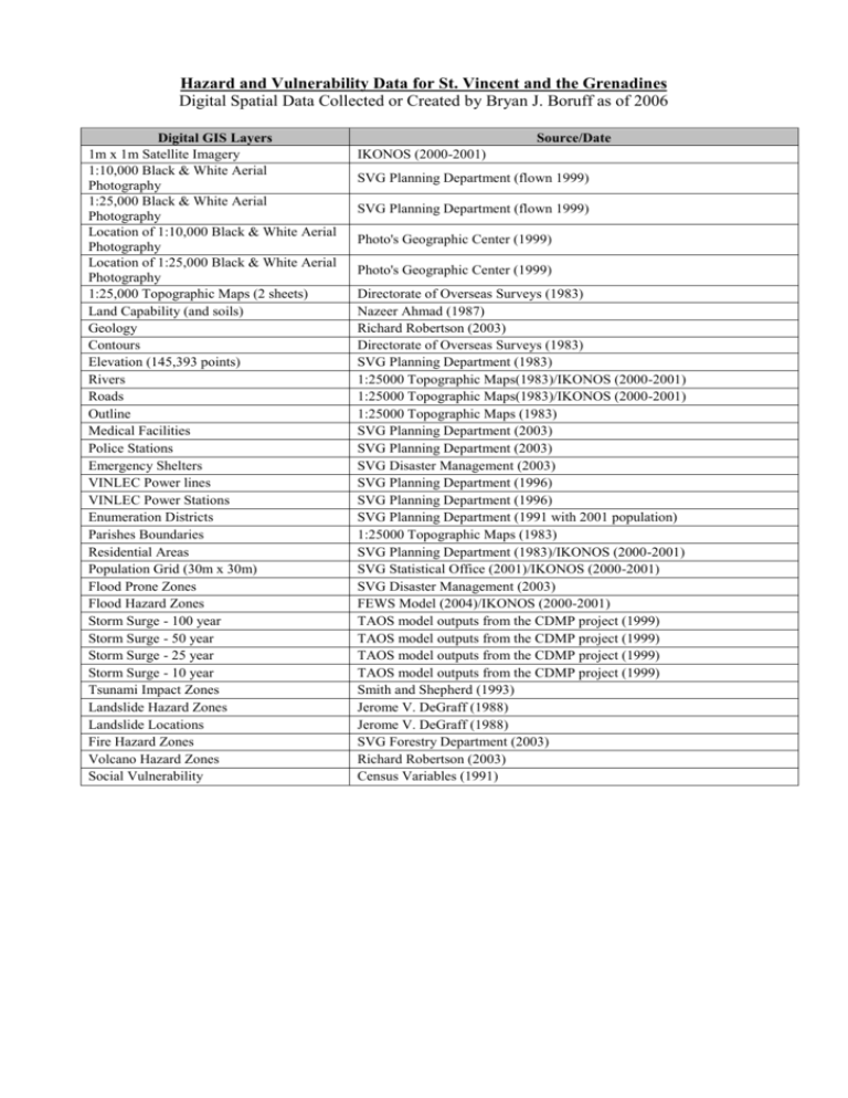
Hazard and Vulnerability Data for St. Vincent and the Grenadines Digital Spatial Data Collected or Created by Bryan J. Boruff as of 2006 Digital GIS Layers 1m x 1m Satellite Imagery 1:10,000 Black & White Aerial Photography 1:25,000 Black & White Aerial Photography Location of 1:10,000 Black & White Aerial Photography Location of 1:25,000 Black & White Aerial Photography 1:25,000 Topographic Maps (2 sheets) Land Capability (and soils) Geology Contours Elevation (145,393 points) Rivers Roads Outline Medical Facilities Police Stations Emergency Shelters VINLEC Power lines VINLEC Power Stations Enumeration Districts Parishes Boundaries Residential Areas Population Grid (30m x 30m) Flood Prone Zones Flood Hazard Zones Storm Surge - 100 year Storm Surge - 50 year Storm Surge - 25 year Storm Surge - 10 year Tsunami Impact Zones Landslide Hazard Zones Landslide Locations Fire Hazard Zones Volcano Hazard Zones Social Vulnerability Source/Date IKONOS (2000-2001) SVG Planning Department (flown 1999) SVG Planning Department (flown 1999) Photo's Geographic Center (1999) Photo's Geographic Center (1999) Directorate of Overseas Surveys (1983) Nazeer Ahmad (1987) Richard Robertson (2003) Directorate of Overseas Surveys (1983) SVG Planning Department (1983) 1:25000 Topographic Maps(1983)/IKONOS (2000-2001) 1:25000 Topographic Maps(1983)/IKONOS (2000-2001) 1:25000 Topographic Maps (1983) SVG Planning Department (2003) SVG Planning Department (2003) SVG Disaster Management (2003) SVG Planning Department (1996) SVG Planning Department (1996) SVG Planning Department (1991 with 2001 population) 1:25000 Topographic Maps (1983) SVG Planning Department (1983)/IKONOS (2000-2001) SVG Statistical Office (2001)/IKONOS (2000-2001) SVG Disaster Management (2003) FEWS Model (2004)/IKONOS (2000-2001) TAOS model outputs from the CDMP project (1999) TAOS model outputs from the CDMP project (1999) TAOS model outputs from the CDMP project (1999) TAOS model outputs from the CDMP project (1999) Smith and Shepherd (1993) Jerome V. DeGraff (1988) Jerome V. DeGraff (1988) SVG Forestry Department (2003) Richard Robertson (2003) Census Variables (1991)


![Property`s Of 2D and 3D Shapes.! :] - Odessa R-VII](http://s2.studylib.net/store/data/005712562_2-5f3fcc92381e7510fd57ce4e0ef497c8-300x300.png)
