doc - WMO
advertisement
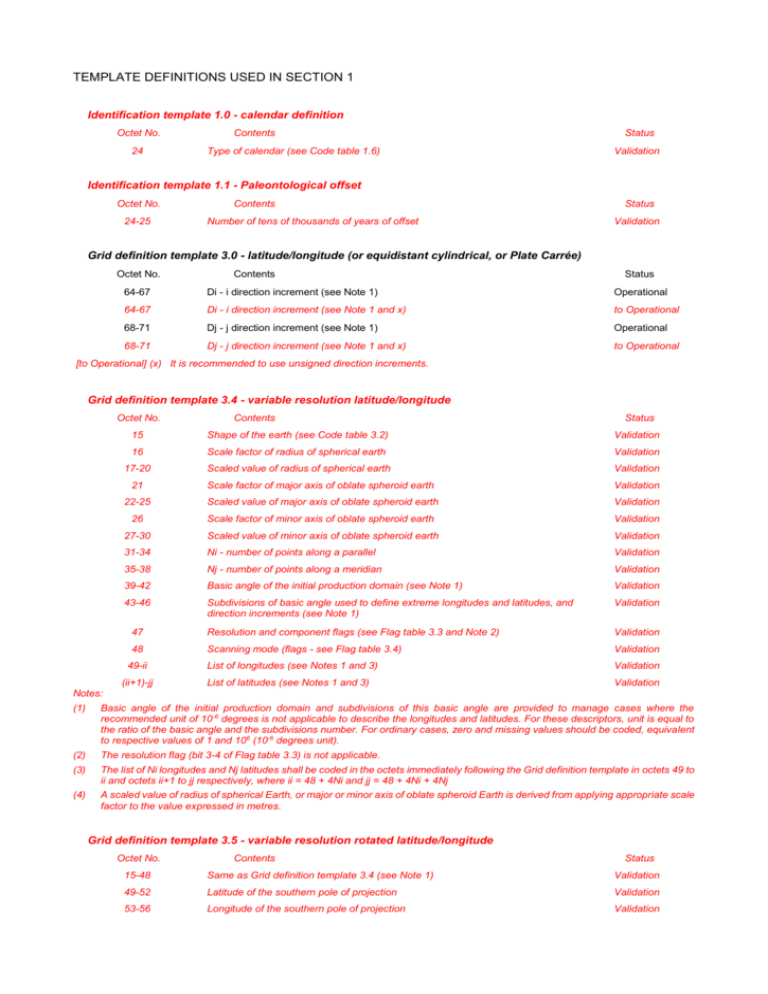
TEMPLATE DEFINITIONS USED IN SECTION 1 Identification template 1.0 - calendar definition Octet No. 24 Contents Type of calendar (see Code table 1.6) Status Validation Identification template 1.1 - Paleontological offset Octet No. 24-25 Contents Number of tens of thousands of years of offset Status Validation Grid definition template 3.0 - latitude/longitude (or equidistant cylindrical, or Plate Carrée) Octet No. Contents Status 64-67 Di - i direction increment (see Note 1) Operational 64-67 Di - i direction increment (see Note 1 and x) to Operational 68-71 Dj - j direction increment (see Note 1) Operational 68-71 Dj - j direction increment (see Note 1 and x) to Operational [to Operational] (x) It is recommended to use unsigned direction increments. Grid definition template 3.4 - variable resolution latitude/longitude Octet No. Contents Status 15 Shape of the earth (see Code table 3.2) Validation 16 Scale factor of radius of spherical earth Validation 17-20 Scaled value of radius of spherical earth Validation 21 Scale factor of major axis of oblate spheroid earth Validation 22-25 Scaled value of major axis of oblate spheroid earth Validation 26 Scale factor of minor axis of oblate spheroid earth Validation 27-30 Scaled value of minor axis of oblate spheroid earth Validation 31-34 Ni - number of points along a parallel Validation 35-38 Nj - number of points along a meridian Validation 39-42 Basic angle of the initial production domain (see Note 1) Validation 43-46 Subdivisions of basic angle used to define extreme longitudes and latitudes, and direction increments (see Note 1) Validation 47 Resolution and component flags (see Flag table 3.3 and Note 2) Validation 48 Scanning mode (flags - see Flag table 3.4) Validation List of longitudes (see Notes 1 and 3) Validation List of latitudes (see Notes 1 and 3) Validation 49-ii (ii+1)-jj Notes: (1) Basic angle of the initial production domain and subdivisions of this basic angle are provided to manage cases where the recommended unit of 10-6 degrees is not applicable to describe the longitudes and latitudes. For these descriptors, unit is equal to the ratio of the basic angle and the subdivisions number. For ordinary cases, zero and missing values should be coded, equivalent to respective values of 1 and 106 (10-6 degrees unit). (2) The resolution flag (bit 3-4 of Flag table 3.3) is not applicable. (3) The list of Ni longitudes and Nj latitudes shall be coded in the octets immediately following the Grid definition template in octets 49 to ii and octets ii+1 to jj respectively, where ii = 48 + 4Ni and jj = 48 + 4Ni + 4Nj (4) A scaled value of radius of spherical Earth, or major or minor axis of oblate spheroid Earth is derived from applying appropriate scale factor to the value expressed in metres. Grid definition template 3.5 - variable resolution rotated latitude/longitude Octet No. Contents Status 15-48 Same as Grid definition template 3.4 (see Note 1) Validation 49-52 Latitude of the southern pole of projection Validation 53-56 Longitude of the southern pole of projection Validation 57-60 61-ii (ii+1)-jj Angle of rotation of projection Validation List of longitudes (see Notes 1 and 3) Validation List of latitudes (see Notes 1 and 3) Validation Notes: (1) Basic angle of the initial production domain and subdivisions of this basic angle are provided to manage cases where the recommended unit of 10–6 degrees is not applicable to describe the longitudes and latitudes. For these descriptors, the unit is equal to the ratio of the basic angle and the subdivisions number. For ordinary cases, zero and missing values should be coded, equivalent to respective values of 1 and 106 (10–6 degrees unit). (2) Three parameters define a general latitude/longitude coordinate system, formed by a general rotation of the sphere. One choice for these parameters is: (a) The geographic latitude in degrees of the southern pole of the coordinate system, e.g θp; (b) The geographic longitude in degrees of the southern pole of the coordinate system, e.g λ p; (c) The angle of rotation in degrees about the new polar axis (measured clockwise when looking from the southern to the northern pole) of the coordinate system, assuming the new axis to have been obtained by first rotating the sphere through λ p degrees about the geographic polar axis, and then rotating through (90 + θp) degrees so that the southern pole moved along the (previously rotated) Greenwich meridian. (3) For the list of Ni longitude bounds and Nj latitude bounds at the end of the section ii = 60 + 4Ni and jj = 60 + 4Ni +4Nj Grid definition template 3.11 - rotated Mercator projection Octet No. Contents Status 15 Shape of the earth (see Code table 3.2) Validation 16 Scale factor of radius of spherical earth Validation 17-20 Scaled value of radius of spherical earth Validation 21 Scale factor of major axis of oblate spheroid earth Validation 22-25 Scaled value of major axis of oblate spheroid earth Validation 26 Scale factor of minor axis of oblate spheroid earth Validation 27-30 Scaled value of minor axis of oblate spheroid earth Validation 31-34 Ni - number of points along a parallel Validation 35-38 Nj - number of points along a meridian Validation 39-42 La1 - latitude of first grid point Validation 43-46 Lo1 - longitude of first grid point Validation Resolution and component flags (see Flag table 3.3) Validation 48-51 47 LaD -latitude(s) at which the Mercator projection intersects the Earth (latitude(s) where Di and Dj are specified) Validation 52-55 La2 - latitude of last grid point Validation 56-59 Lo2 - longitude of last grid point Validation Scanning mode (flags - see Flag table 3.4) Validation 61-64 60 Orientation of the grid, angle between i direction on the map and the equator (see Note 1) Validation 65-68 Di - longitudinal direction grid length (see Note 2) Validation 69-72 Dj - latitudinal direction grid length (see Note 2) Validation 73-76 La0 - geographical latitude of the point to be brought to the origin of the projection, in the case of a rotation of the sphere prior to the projection Validation 77-80 Lo0 - geographical longitude of the point to be brought to the origin of the projection, in the case of a rotation of the sphere prior to the projection Validation 81-84 beta – tilting angle of the sphere around the origin point of the rotated sphere Validation 85-nn List of number of points along each meridian or parallel (These octets are only present for quasi-regular grids as described in Notes 2 and 3 of GDT 3.1) Validation Notes: (1) Limited to the range of 0 to 90 degrees; if the angle of orientation of the grid is neither 0 nor 90 degrees, Di and Dj must be equal to each other. (2) Grid lengths are in units of 10-3 m, at the latitude specified by LaD. (3) A scaled value of radius of spherical Earth, or major or minor axis of oblate spheroid Earth is derived from applying appropriate scale factor to the value expressed in metres. (4) Transformation formulas from geographical (lat,lon) = (θ,λ) to projected grid point coordinates (x,y) : sin( ' ) cos( 0 ) sin( ) sin( 0 ) cos( ) cos( 0 ) cos( ' ) 1 sin 2 ( ' ) C ' cos( ' ) cos( ' ) sin( 0 ) sin( ) cos( 0 ) cos( ) cos( 0 ) S ' cos( ' ) sin( ' ) cos( ) sin( 0 ) ' ' arcsin[cos ( ) sin( ' ) sin( ) S ' ] C' cos( ' ' ) 1 sin( ' ' ) [sin( ) sin( ' ) cos( ) S ' ] cos( ' ' ) x a ' ' '' y a. ln[ tg ( )] 4 2 cos( ' ' ) Reverse transformation formulas from gridpoint (x,y) to (lat,lon): '' x a y )] a 1 exp( 2 y / a ) sin( ' ' ) 1 exp( 2 y / a ) sin( ' ) cos( 0 ) sin( ) sin( 0 ) cos( ) cos( 0 ) '' 2 2.arctg[exp( cos( ' ) 1 sin 2 ( ' ) C ' cos( ' ' ) cos( ' ' ) S ' sin( ) sin( ' ' ) cos( ) cos( ' ' ) sin( ' ' ) arcsin[cos ( 0 ) sin( ' ) sin( 0 )C ' ] 1 [ sin( 0 ) sin( ' ) cos( 0 )C ' ] cos( ) S' sin( 0 ) cos( ) cos( 0 ) Where: - La0 is θ0 Lo0 is λ0 Beta is β x and y are metric coordinates in the i and j direction, in standard units (m). (x,y) = (0,0) corresponds to the coordinate of the reference point (La0,Lo0), provided this point is kept as the centre of the grid point domain. the other variables are intermediate ones. More explanation can be found in the Technical Note by P. Bénard (2011), “rotated/tilted Mercator geometry in Aladin”. Grid definition template 3.12 - transverse Mercator Octet No. Contents Status 15 Shape of the Earth (see Code table 3.2) Validation 16 Scale factor of radius of spherical Earth Validation 17-20 Scaled value of radius of spherical Earth Validation 21 Scale factor of major axis of oblate spheroid Earth Validation 22-25 Scaled value of major axis of oblate spheroid Earth Validation 26 Scale factor of minor axis of oblate spheroid Earth Validation 27-30 Scaled value of minor axis of oblate spheroid Earth Validation 31-34 Ni - number of points along i-axis Validation 35-38 Nj - number of points along j-axis Validation 39-42 LaR - geographic latitude of reference point Validation 43-46 LoR - geographic longitude of reference point Validation Resolution and component flags (see Flag table 3.3) Validation 48-51 m - scale factor at reference point ratio of distance on map to distance on Validation 52-55 XR - false easting, i-direction coordinate of reference point (10-2 m) Validation 47 56-59 YR - false northing, j-direction coordinate of reference point (10-2 m) Validation Scanning mode (flags - see Flag table 3.4) Validation 61-64 Di - i-direction increment length (10-3 m) Validation 65-68 Dj - j-direction increment length (10-3 m) Validation 69-72 x1 - i-direction coordinate of the first grid point (10-2 m) Validation 73-76 y1 - j-direction coordinate of the first grid point (10-2 m) Validation 77-80 x2 - i-direction coordinate of the last grid point (10-2 m) Validation 81-84 y2 - j-direction coordinate of the last grid point (10-2 m) Validation 60 Grid definition template 3.40 - Gaussian latitude/longitude Octet No. Contents Status 64-67 Di - i direction increment (see Note 1) Operational 64-67 Di - i direction increment (see Notes 1 and x) to Operational [to Operational] (x) It is recommended to use unsigned direction increments. Grid definition template 3.101 - general unstructured grid Octet No. 15 16-18 19 Contents Status Shape of the Earth (see Code table 3.2) Validation Number of grid used (defined by originating centre) Validation Number of grid in reference (to allow annotating for Arakawa C-grid on arbitrary grid) (see Note 1) Validation Note: (1) The Number is associated with an attribute of the respective grid description which consists of the centre longitude/latitude and the longitude/latitude of the boundary polygon vertices. Variables can be defined on different positions in the triangle. This leads to different sets of geo locations, e.g.: 1. triangles (i) (pressure, temperature,..) 2. quads (l) (wind velocity ..) 3. hexagons respectively pentagons (v) (vorticity) TEMPLATE DEFINITIONS USED IN SECTION 4 Product definition template 4.48 - analysis or forecast at a horizontal level or in a horizontal layer at a point in time for optical properties of aerosol Octet No. Contents Status 10 Parameter category (see Code table 4.1) Validation 11 Parameter number (see Code table 4.2) Validation Aerosol type (see Code table C-14) Validation 14 Type of interval for first and second size (see Code table 4.91) Validation 15 Scale factor of first size Validation Scaled value of first size in metres Validation Scale factor of second size Validation Scaled value of second size in metres Validation 25 Type of interval for first and second wavelength (see Code table 4.91) Validation 26 Scale factor of first wavelength Validation Scaled value of first wavelength in metres Validation Scale factor of second wavelength Validation 12-13 16-19 20 21-24 27-30 31 32-35 Scaled value of second wavelength in metres Validation 36 Type of generating process (see Code table 4.3) Validation 37 Background generating process identifier (defined by originating centre) Validation 38 Analysis or forecast generating processes identifier (defined by originating centre) Validation Hours of observational data cut-off after reference time (see Note 1) Validation 41 Minutes of observational data cut-off after reference time Validation 42 Indicator of unit of time range (see Code table 4.4) Validation 39-40 43-46 Forecast time in units defined by octet 42 Validation 47 Type of first fixed surface (see Code table 4.5) Validation 48 Scale factor of first fixed surface Validation 49-52 Scaled value of first fixed surface Validation 53 Type of second fixed surface (see Code table 4.5) Validation 54 Scale factor of second fixed surface Validation 55-58 Scaled value of second fixed surface Validation Note: Hours greater than 65534 will be coded as 65534. Product definition template 4.50 - analysis or forecast of a multi component parameter or matrix element at a point in time Octet No. Contents Status 10 Parameter category (see Code table 4.1) Validation 11 Parameter number (see Code table 4.2) Validation 12 Type of generating process (see Code table 4.3) Validation 13 Background generating process identifier (defined by originating centre) Validation 14 Analysis or forecast generating processes identifier (defined by originating centre) Validation Hours of observational data cut-off after reference time (see Note 1) Validation 17 Minutes of observational data cut-off after reference time Validation 18 Indicator of unit of time range (see Code table 4.4) Validation 15-16 19-22 Forecast time in units defined by octet 18 Validation 23 Type of first fixed surface (see Code table 4.5) Validation 24 Scale factor of first fixed surface Validation 25-28 Scaled value of first fixed surface Validation 29 Type of second fixed surface (see Code table 4.5) Validation 30 Scale factor of second fixed surface Validation 31-34 Scaled value of second fixed surface Validation 35 First dimension physical significance (Code table 5.3) (see Note 2) Validation 36 Second dimension physical significance (Code table 5.3) (see Note 2) Validation 37-40 First dimension coordinate value (IEEE 32-bit floating-point value) Validation 41-44 Second dimension coordinate value (IEEE 32-bit floating-point value) Validation 45-48 First dimension (rows) of the complete matrix (see Note 3) Validation 49-52 Second dimension (columns) of the complete matrix (see Note 3) Validation Notes: (1) Hours greater than 65534 will be coded as 65534. (2) In case of ocean wave spectra e.g., according to Code table 5.3, the physical significance values are 1 (Direction Degrees true) and 2 (Frequency (s–1). (3) The dimensions define the number of GRIBs needed for reconstruction of a complete matrix (e.g. wave spectrum) at one or more grid points. In case of vectors (1-dim-matrices), the second dimension must be set to 1 and the second dimension physical significance must be set to 255 (missing). In case of multi component parameter (e.g. no matrix or vector element), first and second dimension are set to 1. TEMPLATE DEFINITIONS USED IN SECTION 5 Data representation template 5.42 - Grid point and spectral data - CCSDS szip Octet No. Contents Status 12-15 Reference value (R) (IEEE 32-bit floating-point value) Validation 16-17 Binary scale factor (E) Validation 18-19 Decimal scale factor (D) Validation 20 Number of bits required to hold the resulting scaled and referenced data values. Validation 21 Type of original field values (see Code table 5.1) Validation 22 szip options mask Validation 23 szip bits per pixel Validation 24-25 szip pixels per block Validation 26-27 szip pixels per scan line Validation Notes: (1) The intent of this template is to scale the grid point data to obtain desired precision, if appropriate, and then subtract out reference value from the scaled field as is done using Data Representation Template 5.0. After this, the resulting grid point field can be treated as a grayscale image and is then encoded into the CCSDS szip code stream format. To unpack the data field, the CCSDS szip code stream is decoded back into an image, and the original field is obtained from the image data as described in regulation 92.9.4, Note (4). (2) The Consultative Committee for Space Data Systems (CCSDS) szip is the standard used by space agencies for the compression of scientific data transmitted from satellites and other space instruments. CCSDS szip is a very fast predictive compression algorithm based on the extended-Rice algorithm, it uses Golomb-Rice codes for entropy coding. The sequence of prediction errors is divided into blocks. Each block is compressed using a two-pass algorithm. In the first pass the best coding method for the whole block is determined. In the second pass, output of the marker of the selected coding method as a side information is done along with prediction errors encoded. The coding methods include: - Golomb-Rice codes of a chosen rank - Unary code for transformed pairs of prediction errors - Fixed-length natural binary code if the block is found to be incompressible - Signaling to the decoder empty block if all prediction errors are zeroes A detailed description can be found in: Consultative Committee for Space Data Systems: Lossless Data Compression. CCSDS Recommendation for Space System Data Standards, CCSDS 121.0-B-1, Blue Book, May 1997. Note: CCSDS szip is often confused with a general-purpose compression utility by Schindler, which is also called szip. TEMPLATE DEFINITIONS USED IN SECTION 7 None
