Large-scale-circulation-of-NA - Mar-Eco
advertisement
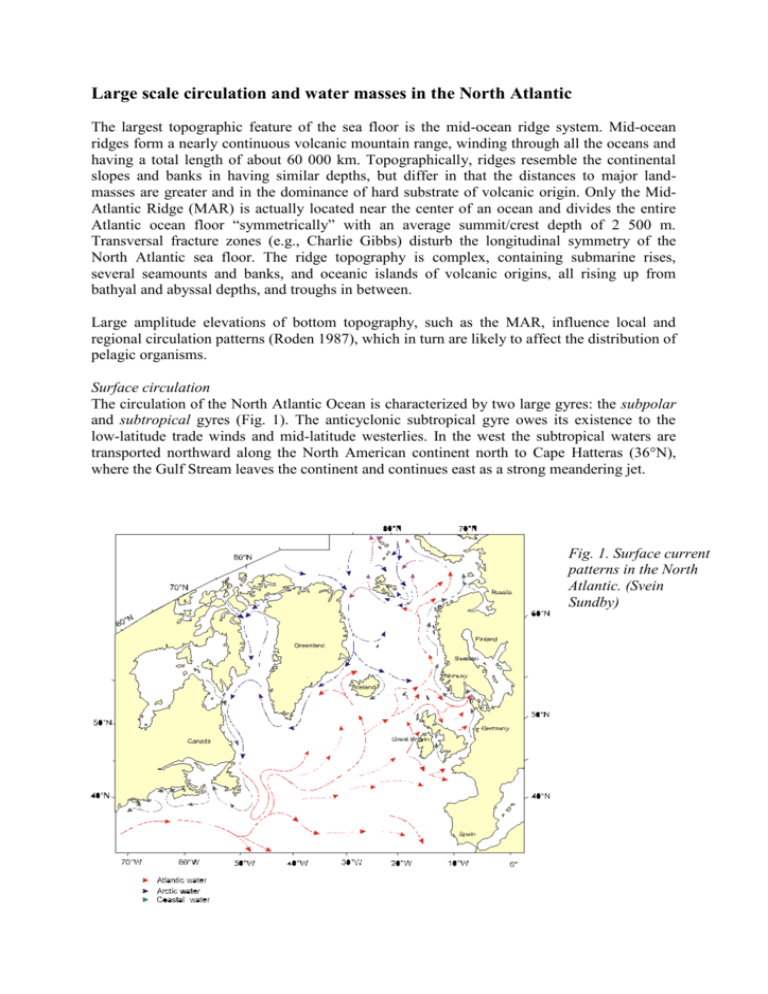
Large scale circulation and water masses in the North Atlantic The largest topographic feature of the sea floor is the mid-ocean ridge system. Mid-ocean ridges form a nearly continuous volcanic mountain range, winding through all the oceans and having a total length of about 60 000 km. Topographically, ridges resemble the continental slopes and banks in having similar depths, but differ in that the distances to major landmasses are greater and in the dominance of hard substrate of volcanic origin. Only the MidAtlantic Ridge (MAR) is actually located near the center of an ocean and divides the entire Atlantic ocean floor “symmetrically” with an average summit/crest depth of 2 500 m. Transversal fracture zones (e.g., Charlie Gibbs) disturb the longitudinal symmetry of the North Atlantic sea floor. The ridge topography is complex, containing submarine rises, several seamounts and banks, and oceanic islands of volcanic origins, all rising up from bathyal and abyssal depths, and troughs in between. Large amplitude elevations of bottom topography, such as the MAR, influence local and regional circulation patterns (Roden 1987), which in turn are likely to affect the distribution of pelagic organisms. Surface circulation The circulation of the North Atlantic Ocean is characterized by two large gyres: the subpolar and subtropical gyres (Fig. 1). The anticyclonic subtropical gyre owes its existence to the low-latitude trade winds and mid-latitude westerlies. In the west the subtropical waters are transported northward along the North American continent north to Cape Hatteras (36°N), where the Gulf Stream leaves the continent and continues east as a strong meandering jet. Fig. 1. Surface current patterns in the North Atlantic. (Svein Sundby) As the Gulf Stream approaches the Great Banks, the transport decreases as some of the water is re-circulated to the west, some water continues east and crosses the MAR in the Azores Current and the remainder forms the North Atlantic Current (NAC) that continues as a welldefined boundary current along the eastern slope of the Grand Banks. At about 51°N the NAC moves to the east. As the waters flow eastward the NAC looses its structure as a well-defined jet, and the water is transported eastward in the Sub Polar Front (SPF), which is the boundary between the warm water in the subtropical gyre and the cooler and less saline water in the subpolar gyre to the north (Rossby 1999). The eastward transport of warm water is split in at least two and maximum four branches (Sy et al., 1992). At the MAR these branches are found between 45°N and the Charlie Gibbs Fracture Zone (CGFZ, ~52°N; Harvey and Ahran 1988). Surface drifters (Fratantoni 2001) indicate that very little surface water is transported across the ridge between the CGZF and the Azores Current (AC) that crossed the MAR to the south of the Azores. East of the MAR the SPF makes a sharp turn toward the north and some of the warm water in the SPF eventually feeds the Irminger Current and some feeds the inflow of warm water to the Nordic Seas to both sides of the Faroes Islands. Deep-water circulation The major source of North Atlantic Deep Water (80%) is the Norwegian Sea (Fig. 2), from which water flows south over the sills between Scotland and Iceland (Iceland-Scotland Overflow Water, ISOW). The overflow water mixes with North Atlantic Central Water to form Northeast Atlantic Deep Water (NEADW). Some of this NEADW continues south in the eastern basin of the North Atlantic, over Atlantic Bottom Water. The remainder of the NEADW flows west across the MAR into the western basin. The path of the NEADW follows the bottom topography, along the flanks of Rockall Plateau, making a cyclonic circulation in the Iceland basin, and then turning south along the eastern flanks of the Reykjanes Ridge (Laj et al 2002). The southward flow of deep-water leave the eastern Atlantic, mainly through the Charlie Gibbs Fracture Zone (Bersch 1995). A part of this flow enters the Irminger Basin, while the major part joins the Deep Western Boundary Current in the Labrador Basin. An overflow of Norwegian Sea Deep water also occurs across the sill between Iceland and Greenland (Denmark Strait Overflow Water, DSOW). This flows south-west along the continental slope of Greenland, picking up modified Labrador Sea water (LSW), and when deeper, some Northeast Atlantic Deep Water (NEADW). Fig. 2. Main pathways of intermediate and deep-water masses in the North Atlantic. This mixed water descends into the western basin of the North Atlantic to form the Northwest Atlantic Bottom Water (NWABW) (Warren 1981). Subsurface drifters launched in the SPF to the west of the MAR, were typically (but not all!) funneled across the MAR at the CGFZ (Bower et al. 2002). The CGFZ is also a main passage way for low salinity intermediate depth mode waters from the Labrador Sea, Labrador Sea Water (LSW), into the eastern North Atlantic. Below the LSW, Iceland-Scotland Overflow Water (ISOW) originating in the Nordic Seas flows toward the west in the CGFZ. ). The CGFZ is thus the major opening, not just for the upper ocean but also for deep waters (Rossby 1999). Fronts Fronts depict horizontal and vertical boundaries between different water masses and can occur at all scales of time and space. Thus fronts can serve as distribution barriers, mixing zones, concentration zones, and areas of enhanced production, areas of vertical export, areas of horizontal transport, areas of temperature and salinity anomalies (Neumann 1968), Sournia 1994). The major oceanic fronts above the MAR of the North Atlantic are the Azores Front (AF), associated with the Azores Current and the Sub Polar Front (SPF). Whereas the SPF is clearly visible in sea surface temperatures (SST) satellite images, the front associated with the AC does not have a very distinct SST signal. However, the front is evident in temperature sections south of the front where there is a 18°C thermostad of Sargasso Sea water that is virtually absent north of the front (Gould 1985). References Bersch M (1995) On the circulation of the northesatern North Atlantic. Deep-Sea Research part I 42: 1583-1607 Neumann G (1968) Ocean currents. Elsevier, Amsterdam, London, New York Roden GI (1987) Effect of seamount chains on ocean circulation and thermohaline structure. In: Boehlert GW (ed) Geophysical monograph 43. American Geophysical Union, Washington DC, pp 335-354 Rossby T (1999) On gyre interactions. Deep-Sea Research part II 46: 139-164 Warren BA (1981) Deep circulation of the world ocean Evolution of physical oceanography, scientific surveys in honor of Henry Stommel. MIT Press, Cambridge, MA, pp 6-41
