Part 3 Erosion Prone Areas Overlay Code
advertisement
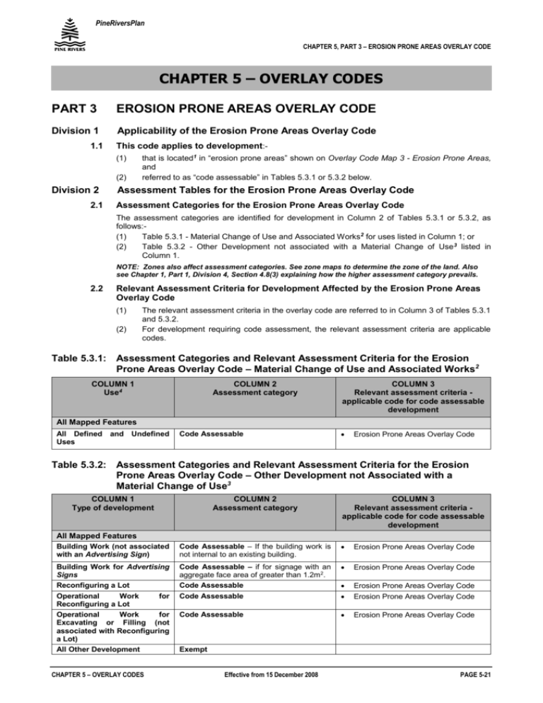
PineRiversPlan CHAPTER 5, PART 3 – EROSION PRONE AREAS OVERLAY CODE CHAPTER 5 – OVERLAY CODES PART 3 EROSION PRONE AREAS OVERLAY CODE Division 1 Applicability of the Erosion Prone Areas Overlay Code 1.1 This code applies to development:(1) (2) Division 2 2.1 that is located1 in “erosion prone areas” shown on Overlay Code Map 3 - Erosion Prone Areas, and referred to as “code assessable” in Tables 5.3.1 or 5.3.2 below. Assessment Tables for the Erosion Prone Areas Overlay Code Assessment Categories for the Erosion Prone Areas Overlay Code The assessment categories are identified for development in Column 2 of Tables 5.3.1 or 5.3.2, as follows:(1) Table 5.3.1 - Material Change of Use and Associated Works2 for uses listed in Column 1; or (2) Table 5.3.2 - Other Development not associated with a Material Change of Use 3 listed in Column 1. NOTE: Zones also affect assessment categories. See zone maps to determine the zone of the land. Also see Chapter 1, Part 1, Division 4, Section 4.8(3) explaining how the higher assessment category prevails. 2.2 Relevant Assessment Criteria for Development Affected by the Erosion Prone Areas Overlay Code (1) (2) The relevant assessment criteria in the overlay code are referred to in Column 3 of Tables 5.3.1 and 5.3.2. For development requiring code assessment, the relevant assessment criteria are applicable codes. Table 5.3.1: Assessment Categories and Relevant Assessment Criteria for the Erosion Prone Areas Overlay Code – Material Change of Use and Associated Works2 COLUMN 1 Use4 COLUMN 2 Assessment category COLUMN 3 Relevant assessment criteria applicable code for code assessable development All Mapped Features All Defined and Undefined Uses Code Assessable Erosion Prone Areas Overlay Code Table 5.3.2: Assessment Categories and Relevant Assessment Criteria for the Erosion Prone Areas Overlay Code – Other Development not Associated with a Material Change of Use3 COLUMN 1 Type of development COLUMN 2 Assessment category COLUMN 3 Relevant assessment criteria applicable code for code assessable development All Mapped Features Building Work (not associated with an Advertising Sign) Code Assessable – If the building work is not internal to an existing building. Erosion Prone Areas Overlay Code Building Work for Advertising Signs Reconfiguring a Lot Operational Work for Reconfiguring a Lot Operational Work for Excavating or Filling (not associated with Reconfiguring a Lot) All Other Development Code Assessable – if for signage with an aggregate face area of greater than 1.2m2. Code Assessable Erosion Prone Areas Overlay Code Erosion Prone Areas Overlay Code Code Assessable Erosion Prone Areas Overlay Code Code Assessable Erosion Prone Areas Overlay Code CHAPTER 5 – OVERLAY CODES Exempt Effective from 15 December 2008 PAGE 5-21 PineRiversPlan CHAPTER 5, PART 3 – EROSION PRONE AREAS OVERLAY CODE Division 3 3.1 Division 4 Compliance with the Erosion Prone Areas Overlay Code Assessable development that is consistent with the specific outcomes contained in Division 5, Table 5.3.3 complies with the Erosion Prone Areas Overlay Code. Overall Outcomes for the Erosion Prone Areas Overlay Code 4.1 The overall outcomes are the purpose of this code. 4.2 The overall outcomes sought by the Erosion Prone Areas Overlay Code are the following:(1) (2) Division 5 5.1 Erosion prone areas are protected as much as practicable from the adverse impacts of development; and Adverse impacts on public safety and damage to property are avoided as far as practicable. Specific Outcomes for the Erosion Prone Areas Overlay Code The specific outcomes and probable solutions for the Erosion Prone Areas Overlay Code are contained in Table 5.3.3. The elements covered by the specific outcomes are:(1) (2) (3) (4) Impact of Development Bed and Bank Erosion Remediation Ecological Impacts CHAPTER 5 – OVERLAY CODES Effective from 15 December 2008 PAGE 5-22 PineRiversPlan CHAPTER 5, PART 3 – EROSION PRONE AREAS OVERLAY CODE Table 5.3.3: Specific Outcomes and Probable Solutions for Assessable Development Specific Outcomes for Assessable Development Probable Solutions Complies (please tick) or Proposed Solution Applicant Council Use Impact of Development SO 1 New development or intensification of existing development is carried out in a manner which has no significant adverse impact on that area or the material processes within that area. PS 1.1 Further building and infrastructure within the erosion prone area:(1) does not extend seaward of the existing building alignment of neighbouring properties; or (2) are located landward of the seaward alignment of existing buildings. AND PS 1.2 The scale of new development is not greater than existing uses. AND PS 1.3 New buildings and structures are temporary or relocatable. Bed and Bank Erosion SO 2 Bed and bank areas of watercourses and tidal areas are protected from development that would accelerate erosion processes leading to bed erosion at a faster rate than that which occurs naturally. CHAPTER 5 – OVERLAY CODES PS 2.1 Development of land:(1) does not involve materials extraction; or (2) does not involve alterations to existing surface levels; or (3) does not involve removal of vegetation or otherwise change the slope, shape, alignment or stability of the bank. AND PS 2.2 Development which involves discharge of stormwater:(1) does not involve discharge of stormwater at a point source to or through land within the erosion prone areas; (2) does not increase stormwater flows over erosion prone land beyond the levels which existed prior to the development occurring; and (3) does not increase the level of the water table within the erosion prone area above that which existed prior to the development occurring. Effective from 15 December 2008 PAGE 5-23 PineRiversPlan CHAPTER 5, PART 3 – EROSION PRONE AREAS OVERLAY CODE Specific Outcomes for Assessable Development Probable Solutions Complies (please tick) or Proposed Solution Applicant Council Use Remediation SO 3 Development minimises risk by incorporating natural buffers including remediation of natural areas to minimise erosion. PS 3 No solution provided. Ecological Impacts SO 4 Development which involves discharge of stormwater to or through erosion prone land incorporates measures that maintain the nutrient and contaminant levels in the discharged stormwater to pre-development levels. 1 PS 4 Development of land does not involve:(1) on-site effluent disposal by ground absorption of wastes; or (2) removal of existing vegetation. This overlay code does not apply if the proposed development is outside the mapped areas. 2 Table 5.3.1 refers to material change of use and associated works undertaken at the same time as the material change of use. Also, see planning scheme explanatory notes giving examples that explain the type of development involved in different proposals. 3 Table 5.3.2 refers to other development including works not undertaken at the same time as the material change use. Also, see planning scheme explanatory notes giving examples that explain the type of development involved in different proposals 4 For defined uses see Chapter 7, Part 2, Use Definitions Schedule CHAPTER 5 – OVERLAY CODES Effective from 15 December 2008 PAGE 5-24
