Microsoft Word - Final Exploration Report June_2011
advertisement
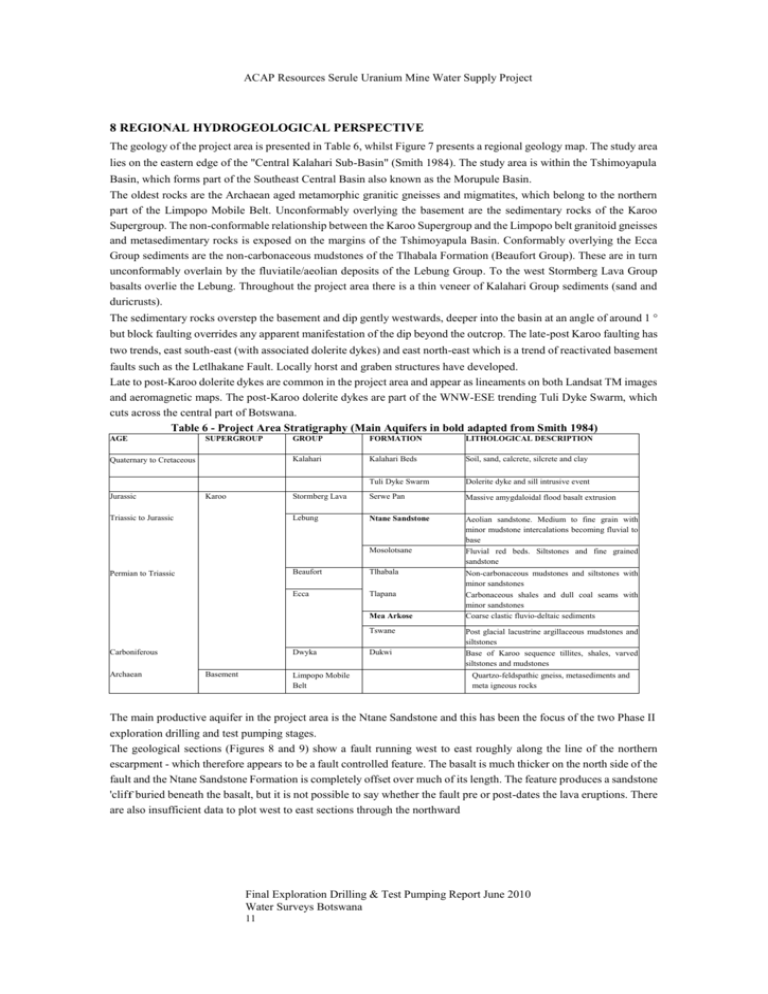
ACAP Resources Serule Uranium Mine Water Supply Project 8 REGIONAL HYDROGEOLOGICAL PERSPECTIVE The geology of the project area is presented in Table 6, whilst Figure 7 presents a regional geology map. The study area lies on the eastern edge of the "Central Kalahari Sub-Basin" (Smith 1984). The study area is within the Tshimoyapula Basin, which forms part of the Southeast Central Basin also known as the Morupule Basin. The oldest rocks are the Archaean aged metamorphic granitic gneisses and migmatites, which belong to the northern part of the Limpopo Mobile Belt. Unconformably overlying the basement are the sedimentary rocks of the Karoo Supergroup. The non-conformable relationship between the Karoo Supergroup and the Limpopo belt granitoid gneisses and metasedimentary rocks is exposed on the margins of the Tshimoyapula Basin. Conformably overlying the Ecca Group sediments are the non-carbonaceous mudstones of the Tlhabala Formation (Beaufort Group). These are in turn unconformably overlain by the fluviatile/aeolian deposits of the Lebung Group. To the west Stormberg Lava Group basalts overlie the Lebung. Throughout the project area there is a thin veneer of Kalahari Group sediments (sand and duricrusts). The sedimentary rocks overstep the basement and dip gently westwards, deeper into the basin at an angle of around 1 ° but block faulting overrides any apparent manifestation of the dip beyond the outcrop. The late-post Karoo faulting has two trends, east south-east (with associated dolerite dykes) and east north-east which is a trend of reactivated basement faults such as the Letlhakane Fault. Locally horst and graben structures have developed. Late to post-Karoo dolerite dykes are common in the project area and appear as lineaments on both Landsat TM images and aeromagnetic maps. The post-Karoo dolerite dykes are part of the WNW-ESE trending Tuli Dyke Swarm, which cuts across the central part of Botswana. Table 6 - Project Area Stratigraphy (Main Aquifers in bold adapted from Smith 1984) AGE SUPERGROUP Quaternary to Cretaceous Jurassic Karoo Triassic to Jurassic Permian to Triassic GROUP FORMATION LITHOLOGICAL DESCRIPTION Kalahari Kalahari Beds Soil, sand, calcrete, silcrete and clay Tuli Dyke Swarm Dolerite dyke and sill intrusive event Stormberg Lava Serwe Pan Massive amygdaloidal flood basalt extrusion Lebung Ntane Sandstone Aeolian sandstone. Medium to fine grain with minor mudstone intercalations becoming fluvial to base Mosolotsane Fluvial red beds. Siltstones and fine grained sandstone Beaufort Tlhabala Non-carbonaceous mudstones and siltstones with minor sandstones Ecca Tlapana Carbonaceous shales and dull coal seams with minor sandstones Coarse clastic fluvio-deltaic sediments Mea Arkose Carboniferous Archaean Dwyka Basement Limpopo Mobile Belt Tswane Post glacial lacustrine argillaceous mudstones and siltstones Dukwi Base of Karoo sequence tillites, shales, varved siltstones and mudstones Quartzo-feldspathic gneiss, metasediments and meta igneous rocks The main productive aquifer in the project area is the Ntane Sandstone and this has been the focus of the two Phase II exploration drilling and test pumping stages. The geological sections (Figures 8 and 9) show a fault running west to east roughly along the line of the northern escarpment - which therefore appears to be a fault controlled feature. The basalt is much thicker on the north side of the fault and the Ntane Sandstone Formation is completely offset over much of its length. The feature produces a sandstone 'cliff buried beneath the basalt, but it is not possible to say whether the fault pre or post-dates the lava eruptions. There are also insufficient data to plot west to east sections through the northward Final Exploration Drilling & Test Pumping Report June 2010 Water Surveys Botswana 11 REGIONAL GEOLOGY MAP 400000 450000 400000 425000 425000 450000 475000 500000 525000 475000 500000 525000 SCALE 1 : 750,000 10 в: H H Projection: UTM Zone 35 South, WGS 84 Datum 10 20 30 40 50 Kilometers ACAP Resources Serule Uranium Mine Water Supply Project limb of the cuesta north of Mmashoro, but the fault is present on the north-west trending limb between Kolokome and Mmashoro. The dolerite dykes separate the aquifer into compartments, but appear not to fully displace the Ntane Sandstone Formation. Thus they may not be considered to act as total barriers to groundwater flow. This is also reflected by the piezometric surface (Figure 11), which shows a northerly flow across them. Figure 8 - Schematic north to south sections through the basin (A, B & C) Final Exploration Drilling & Test Pumping Report June 2010 Water Surveys Botswana 12 ACAP Resources Serule Uranium Mine Water Supply Project Figure 9 - Schematic north to south section through the basin (D) The Ntane Sandstone aquifer in the project area is part of a regional system extending northwards to Sowa Pan, encompassing the Orapa Wellfields and southwards to Serowe. Groundwater levels have been monitored in the BPC Paje Wellfield and extension area boreholes and in boreholes in wellfields at Serowe, and Orapa. These data allow an overview of the regional groundwater flow patterns, shown on Figure 10. Broadly they follow the topography and fall from an elevation of around 1200mamsl on the plateau. to 900mamsl at the margins of the Makgadikgadi Pans. Water levels fall radially away from the plateau above the escarpment with steep gradients to the north and east (off the escarpment faces) and shallower gradients to the west. Groundwater divides run north-east to southwest across the plateau through Serwe Pan; westward more-or less along the Serowe to Orapa road, east towards Serule and northwards along the edge of the escarpment towards Mmasharo and Sowa Pan. The regional flow is therefore divided into four main sub-basins. Final Exploration Drilling & Test Pumping Report June 2010 Water Surveys Botswana 13 ACAP Resources Serule Uranium Mine Water Supply Project Flow to the west is sub-parallel to the regional horst and graben structures and to the dyke swarms whereas flow to the north is perpendicular to them. This has significant implications for the flow which will be less restricted east to west than south to north as the flow in this direction will be impeded by the structures. Moreover, if the escarpment fault system continues northwards then flow to the west from the proposed wellfield area will be restricted by the offset Ntane. In the absence of data to the contrary, the northward continuation of the fault system seems a reasonable assumption because the groundwater divide follows the escarpment. Local groundwater contours (Figure 11) in the study area show flow northwards off the escarpment towards Sowa Pan and eastwards towards the Ntane Sandstone outcrop. Final Exploration Drilling & Test Pumping Report June 2010 Water Surveys Botswana 14


