GEL 341 Laboratory 1: Desert Landscapes of the Basin and Range
advertisement
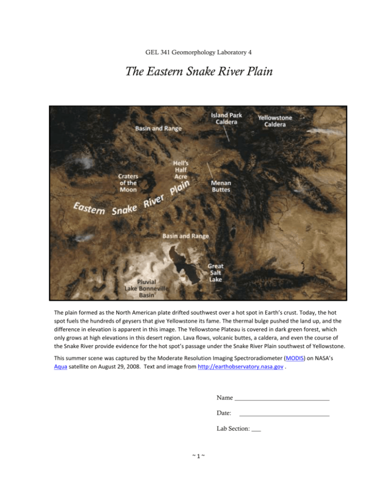
GEL 341 Geomorphology Laboratory 4 The Eastern Snake River Plain The plain formed as the North American plate drifted southwest over a hot spot in Earth’s crust. Today, the hot spot fuels the hundreds of geysers that give Yellowstone its fame. The thermal bulge pushed the land up, and the difference in elevation is apparent in this image. The Yellowstone Plateau is covered in dark green forest, which only grows at high elevations in this desert region. Lava flows, volcanic buttes, a caldera, and even the course of the Snake River provide evidence for the hot spot’s passage under the Snake River Plain southwest of Yellowstone. This summer scene was captured by the Moderate Resolution Imaging Spectroradiometer (MODIS) on NASA’s Aqua satellite on August 29, 2008. Text and image from http://earthobservatory.nasa.gov . Name Date: Lab Section: ___ ~1~ The Eastern Snake River Plain The Snake River Plain is a crescent-shaped region that extends nearly the entire width of southern Idaho (Fig. 1). The western Snake River Plain lies in a deep rift valley that is filled with a thick sequence of rhyolitic and basaltic volcanic rocks and lacustrine sediments. Figure 1. Map showing the northeastward apparent motion of hotspot migration and the ages of the various calderas (Modified from; Barenek et al., 2006; Link et al., 1992; Pierce and Morgan, 1992). ~2~ The eastern Snake River Plain (ESRP) occupies an isostatic depression that was caused by the weight of the volcanic rocks that now fill it (Link, 2010, http://imnh.isu.edu/digitalatlas). This portion of the plain cuts across the north to north-northwest trending structural grain of the Basin and Range province, which borders the ESRP to the north and south. The ESRP formed initially by the passage of the North American Plate over a mantle hotspot and its associated rhyolitic volcanism. This hotspot presently underlies the Yellowstone caldera and is responsible for the violent rhyolitic volcanism associated with the Yellowstone “Supervolcano”. Rhyolitic volcanoes in the ESRP decrease in age from about 12–16 ma (millo anno, million years before present) in southwestern Idaho to about 1–2 ma near the Wyoming border (Fig. 2). Rhyolitic volcanism in the region was succeeded by continental basaltic volcanism. The last basaltic eruptions occurred about 2000 years ago at Craters of the Moon National Monument lava fields. Much of the recent basaltic volcanism occurs along rift zones that are oriented parallel to fault trends in the Basin and Range, but may not be directly related to Basin and Range extension (Kuntz et al., 1992; Hughes et al., 2002). The sequences of lava flows and pyroclastic material that are interbedded with fluvial, lacustrine and eolian sediments in this region make the Snake River Plain Aquifer one of the largest and most productive aquifers in the world (Whitehead, 1994). The Menan Buttes Menan Buttes formed about 10,000 years before present (y.b.p.) are two of the largest maar-diatreme pyroclastic cones in the world (Fig.2). Maars form by phreatomagmatic eruption when rising basaltic or ultramafic magma interacts explosively with groundwater (see Figure 4 in Lorenz (2003)). In the case of the Menan Buttes, the basaltic magmas erupted through saturated gravel in the Snake River and Henry’s Fork valleys. They are the only ones in the United States that formed in this manner (Riebeek, undated, earthobservatory.nasa.gov ). The buttes are composed primarily of olivine-rich tholeiitic basalt and palagonite tuff with pieces of river gravel that became entrapped in the eruption. They are the largest cones in the Menan Volcanic Complex, a group of six pyroclastic cones that erupted along a 5kilometer long, north-northwest trending fissure in the eastern Snake River Plain during the Late Pleistocene (Hughes et al., 1999). Figure 2. The Menan Buttes in southeastern Idaho. Original image was taken by the Advanced Land Imager (ALI) on NASA Earth Observing-1 (EO-1) satellite on 25 September 2010 < http://earthobservatory.nasa.gov > ~3~ Laboratory Exercise This two-week-long laboratory exercise examines the linkages between the tectonic and surficial processes that created the Eastern Snake River Plain (ESRP) landscape; focusing upon the Menan Buttes, the St. Anthony dunes and the fluvial drainage patterns that developed in the region. By the end of this exercise you will be able to; > Extract morphometric data from GIS databases to measure linear dimensions, areas, volumes, elevation, relief and slope of landforms; Construct shaded relief, slope and contour maps; Construct topographic profiles and determine vertical exaggeration Export data from GIS databases for analysis by other analytical software (e.g. spreadsheets or modelling software) Create accurate and effective graphics for presentations or final reports > > > > < More Lab Report Information > Laboratory Outline and Key Topics and Concepts I. Introduction a. Physiographic setting of the Eastern Snake River Plain b. Hotspot tectonics; Regional seismicity, the Yellowstone crescent of high terrain and isostatic adjustments. c. Phreatomagmatic eruptions II. Geomorphic Analysis a. Menan Buttes → Morphology of maar-diatreme cones → Volume of pyroclastic ejecta b. Fluvial Geomorphology → Regional Drainage Network Patterns → Channel pattern, sinuosity and stream gradient c. St. Anthony Dune Field → → → → Dune classification Composition and provenance Relict dunes Loess Deposits III. Geomorphic Synthesis a. b. c. d. Geological context for Cenozoic eruptions Explosivity Index for maar-diatreme cones Tectonic, isostatic and climate controls on channel and drainage network patterns Effects of climate change on fluvial and eolian systems ~4~ Introduction Geologic Setting 4-1. Describe the relationships between the Snake River Plain and the adjacent physiographic regions using the physiographic map that you produced in the first week of the semester (or examine the physiographic map of the US at < http://tapestry.usgs.gov/physiogr/physio.html > Rank 4-2. Examine the seismicity zones that surround the ESRP in Fig.1. Describe the tectonic process that produce seismicity in this region. Is this seismicity related to the extensional faulting in the Basin and Range Province? Rank 4-3. Describe the textures and mineralogic compositions of rhyolite, tholeiitic basalt and palagonite tuff. Would you expect rhyolite and basalt to erupt concurrently? Rank ~5~ Wght Score 1 Wght Score 1 Wght 1 Score 4-4. Describe the eruptive style, formation and internal structure of a maardiatreme volcano and describe the unique geological conditions that controlled the growth of the Menan Buttes tuff cones (see Lorenz, 2003, pp.73 and 79). ~6~ Rank Wght 1 Score Geomorphic Analysis 4-5. Add the USGS-Orthoimagery WMS layer from the USGS TNM Service or open Google Earth and “fly to” Menan Buttes. Adjust the scale of the screen image to the approximate extent of the image in Figure 3 and locate the St. Anthony Dunes and Menan Buttes. Describe the distribution of agriculture in the area. Zoom to the area north and west of Menan Buttes. Explain why there is no agriculture here. Provide evidence to support your answer. Rank Wght Score 1 Figure 3. Natural color orthoimage of the eastern Snake River Plain near Rexburg, Idaho (image © Google Earth). ~7~ The Menan Buttes Rank 4-6. Open ArcMap and upload the digital elevation model provided. Set the data frame projection is UTM, NAD83, Zone 12N. Upload topographic and orthoimage base maps from the Add Basemap and Add Data from ARC GIS online options in the Add Data tab. Wght 2 Use the “interpolate line” and “create profile graphs” tools in 3‒D Analyst to create two southwest to northeast trending topographic profile through the buttes. Be certain that the digital elevation model file name appears in the 3‒D Analyst toolbar window. The profile should pass through the points (UTM NAD83, Zone 12N coordinates); North Menan Butte: 417791m E, 4844252m N and 424024m E, 4851206m N South Menan Butte 419142m E, 4841990m N and 425360m E, 4848953m N Extract the distance and elevation data for each profile and export both sets to the same Excel worksheet. Plot these data on the same graph, Label the profiles appropriately and paste them to the space below. Determine the vertical exaggeration of the profiles and add that value to the caption. Figure 4. Topographic profiles through South Menan and North Menan Butte. Vertical exaggeration = x. ~8~ Score 4-7. Create a map of the profile locations on an orthoimage base map roughly bounded by the UTM coordinates; 417365m E, 4852950m N (NW corner) and 426930m E, 4840700m N (SE corner). Add a graticule grid and scale bar. Paste the completed map to the space provided below Figure 5. Orthoimage basemap of the Mean Buttes, Eastern Snake River Plain, Idaho. ~9~ Rank Wght 2 Score 4-8. Complete the table of morphometric variables for the cone and summit craters for the Menan Buttes (Table 1). Rank Wght Score 2 Table 1. Morphometric variables for the Menan Buttes. South Menan Butte North Menan Butte Cone long Axis (plan) m Cone long Axis (plan) m Cone short axis (plan) m Cone short axis (plan) m Cone long:short axis ratio Cone long:short axis ratio Cone Area (planimetric) m2 Area (planimetric) m2 Relief m Relief m Crater long axis (plan) m Crater long axis (plan) m Crater short axis (plan) m Crater short axis (plan) m Crater long:short axis ratio Crater depth Crater long:short axis ratio m Crater depth m 4-9. Estimate the volume of the pyroclastic material that comprises the Menan Buttes and add the values to Table 2 (below). The volume can be estimated by assuming the buttes are truncated right circular cones (or frustra) that have inverted (crater) frustra removed from their upper surface as shown in the adjacent diagram (Fig.6). Rank 4-10. Sato and Taniguchi (1997) found that the relationship between crater diameter (meters) and cone volume (cubic meters) could be estimated by the expressions; Rank D = 0.11 V0.42 for magmatic (predominantly effusive lava eruptions) or ~ 10 ~ Wght Score 2 Wght 1 Score D = 0.97V0.36 for phreatomagmatic eruptions. The volume of a maar frustrum (including the crater volume) is given the equation; Estimate thebyvolumes for North Menan and South Menan buttes using the equation for phreatomagmatic eruptions and add these values to Table 2. How does these estimates compare 1 2 to your value? 𝑉𝑚 =measured 𝜋𝐻𝑚 (𝑅 + 𝑅1 𝑅2 + 𝑅 2 ) 3 1 2 And the volume of the crater frustrum is given by the equation; 1 𝑉𝑐 = 𝜋𝐻𝑐 (𝑅22 + 𝑅2 𝑅3 + 𝑅32 ) 3 Where R1, R2 and R3 are the average radii of the upper and lower surfaces of each frustrum and Hm and Hc are the heights of the maar and crater frustra, respectively. The volume of the pyroclastic material that comprises the buttes is the difference between the maar and crater frustra; Figure 6. Variables used to calculate the volume of pyroclastic material in the Meanan Buttes. 𝑉 = 𝑉𝑚 − 𝑉𝑐 4-11. Create a slope map for the buttes (using the same general extent as Fig. 5) using the “slope” tool in 3‒D Analyst. Classify the slope angles using 15 classes at 3o intervals. Include a graticule grid, scale bar and legend and paste the completed map space provided below. Rank 2 Table 2. Estimates of the volume of pyroclastic material in the Menan Buttes. Cone Volume (estimated from Sato and Taniguchi (1997) equation) Cone Volume (measured) North Menan Butte m3 m3 South Menan Butte m3 m3 ~ 11 ~ Wght Score Figure 7. Map of slope angles for the Menan Buttes. 4-12. Describe and compare the composition, shape, volume, and slopes of the Menan Buttes cones using the morphometric information in Figs. 4, 5 and 7 and Tables 1 and 2. Of what materials are the cones composed? ~ 12 ~ Rank Wght 2 Score What processes control the size and shape of the cones? What processes control the slopes on the flanks of the pyroclastic cone and the interior slopes of the summit crater (consider both the composition of the cones and their mode of deposition)? ~ 13 ~ Fluvial Geomorphology Note: These questions deal with the evolution of the drainage network in the ESRP region. Please refer to Huggett (2007), Knighton (1998), Lord et al. (2009), Montgomery and Buffington (1998), or other sources of information on fluvial geomorphology if you need help with these questions. Copies of some reference materials will be available in the GIS laboratory. 4-13. Create a map of the drainage patterns in the region using the National Hydrography Geodatabase layer provided and paste it to the space provided in Figure 8 (next page). You may use some creative discretion but the map should highlight the stream network patterns effectively without being too “busy” with unnecessary lines. Rank Wght Score 2 The map should roughly bounded by 370000m E to 483000m E and 4790000m N and 4900000m N UTM, NAD83, Zone 12N (approximately 43 o 15’ 00” N to 44o 15’ 00” N latitude and 111o 15’ 00” W to 112 o 30’ 00” W longitude). 4-14. Describe the channel patterns of the Snake River as it flows from the eastern border of the map area, past South Menan Butte to where it exits the southwestern corner of the map area. Why does the channel pattern change where the Snake River enters Madison County near Ririe? ~ 14 ~ Rank Wght 1 Score Figure 8. Map of channel patterns in the ESRP near the Menan Buttes. ~ 15 ~ 4-15. Describe the channel patterns of Henry’s Fork between North Menan Butte and St. Anthony. What kinds of geomorphic controls favor these patterns (see Lord et al., 2009, Fig. 5)? Rank 4-16. Why are there so few streams to the northwest of the Menan Buttes? Rank Wght 1 Wght 1 ~ 16 ~ Score Score 4-17. Open the shapefile “stream segments” and locate the reaches listed below. Estimate the stream gradients and sinuosity for the stream reaches listed below by extracting elevation data points between the beginning and ending points and exporting these data to Excel. Complete Table 3 below. Rank Wght Score 2 1. Snake River near Palisades, ID (473625m E, 4806962m N to 412813m E, 4799810m N) 2. Snake River near Antelope Flats (465024mE, 4822732m N to 457778m E to 4828528m N) 3. Snake River above Henry’s Fork (431089mE, 4840848m N to 423411m E, 4845352m N) 4. Snake River below Firth, ID (403013m E, 4795919m N to 394566m E, 4790142m N) 5. Henry’s Fork above Snake River (436620m E, 4850967m N to 427157m E to 4851647m N) 6. Henry’s Fork below Warm River (473279m E, 4884309m N to 462075m E, 4883146m N) 7. Teton River above Canyon Creek (472026m E, 4865490m N to 462822m E, 4862776m N) The attribute table in the “stream segments” shapefile contains columns for segment length and the UTM coordinates for the beginning and ending points of each stream segment line. The stream gradients can be obtained using the “Add Surface Information” in ArcToolbox, which will extract elevation data from the raster DEM file. Your instructor will demonstrate this procedure in class. Sinuosity can be determined by the equation; 𝑆= 𝐿𝑐 𝐿 where, Lc is the channel length along the midline of the stream and L is the straight line distance between the beginning and ending point of the stream segment. Channel patterns can be obtained from Knighton (1988); Montgomery and Buffington (1998), Lord et al. (2009) or your textbook. Table 3. Morphology of stream segments on the Snake River, Henry’s Fork and Teton River. Stream Reach Gradient (m/m) Sinuosity Snake River near Palisades, ID Snake River near Antelope Flats Snake River at Henry’s Fork Snake River below Firth, ID Henry’s Fork above Snake River Henry’s Fork below Warm River Teton River above Canyon Creek ~ 17 ~ Channel Pattern St. Anthony Dune Field Note: These questions deal with eolian features in the ESRP. Please refer to Pierce and Scott (1982), Lewis and Fosberg (1982) or other sources of information on eolian geomorphology for assistance with these questions. Copies of some reference materials will be available in the GIS laboratory. 4-18 Add the USGS-Orthoimagery WMS layer from the USGS TNM Service or open Google Earth and fly to the dune field. Describe the morphology (length, width, height, orientation and etc.) of the sand dunes at the St. Anthony dune field south of the South Juniper Buttes and east of the city of St. Anthony. To which morphological class(es) (Fig. 9) do these dunes belong? What does the dune morphology indicate about sediment supply and wind direction in this region? Rank Wght Score 1 Figure 9. Morphology of barchans dunes, barchanoidal ridges and transverse ridges and their relationship to sediment supply (modified from McKee, 1992). ~ 18 ~ 4-19. Do the dunes look as if they are composed of mafic or felsic material? On what evidence do you base your answer? What is/are the likely sources for this material? Rank 4-20. Zoom into a scale larger than about 1:30,000 and examine the northwestern margin of the main dune field southwest of Big Grassy Ridge (roughly centered around 419850m E and 4872390m N UTM Zone 12N, NAD83 or 44o00’ N latitude and 112o 00’ N longitude). Note the subtle SW–NE trending lineated surface landforms in this area. What are these features and what might they indicate about the former extent of the St. Anthony dune field? Rank 4-21. Lewis and Fosberg (1982, Fig. 1) map thick (>175 cm) loess deposits in the low relief plain east of Rexburg (436510m E, 4852880m N UTM Zone 12N, NAD83 or 43o50’ N latitude and 111o 47’ N longitude). What is loess? Where is its likely source(s)? How might these deposits be related to the St. Anthony dunes? Rank ~ 19 ~ Wght Score 1 Wght Score 1 Wght 1 Score Geomorphic Synthesis 4-22. Sato and Taniguchi (1997) found that crater diameters for phreatomagmatic eruptions are 2-5 times larger than magmatic eruptions of similar composition and volume. What does this relationship indicate about the differences in the mechanical energies of magmatic and phreatomagmatic crater formation? Rank Wght Score 3 How do the eruptive energies of the later mafic (basaltic) eruptions compare with the earlier felsic (rhyolitic) eruptions? 4-23. What does the channel pattern of the Snake River and Henry’s Fork reaches in Table 3 indicate about their channel gradient and stability and the caliber of its sediment load (see Lord et al. (2009), Fig. 5)? Rank 4-24. Discuss the possible effects of the tectonic, isostatic and climatic controls in the region on fluvial sediment transport, deposition and channel patterns of the Snake River and Henry’s Fork near the Menan Buttes. Rank ~ 20 ~ Wght Score 3 Wght 3 Score 4-25. Consider the effects of climate change on the fluvial and eolian systems in this region from the late Pleistocene to the present? Are the dune fields and loess deposits more or less extensive now than in the Pleistocene? How might changes in climate affect the flow regime and sediment supply in the fluvial and eolian systems? ~ 21 ~ Rank Wght 3 Score General Information on Laboratory Reports < Back to Introduction > Report Format Geomorphology laboratory exercises follow the format of a technical report and consist of three sections; Introduction, Geomorphic Analysis (i.e. Results) and Geomorphic Synthesis (i.e. Discussion). Each section contains questions or tasks that address a unique aspect or perspective of the subject landform or landscape. The introductory questions provided in this laboratory exercise are designed to review basic terminology and reinforce your understanding of the geologic setting and geomorphic evolution of the subject landscape. In a technical report the Introduction contains all the information the reader will need to understand the content and significance of the research being presented in the text. A good Introduction stimulates the reader’s interest in the research while a poor one may cause the reader to lose interest, even if the research and its conclusions are well founded and relevant. The Geomorphic Analysis section examines specific landforms or landscapes in the region. The word “analysis” refers to breaking an entity apart for the purpose of examining its essential components. It is in this section that you will be asked to do most of the quantitative measurement of the landscape elements. It is not necessary, or even desirable, to include all the results obtained during the course of the investigation. Carefully summarizing the data to emphasize important relationships will help to make this section more readable and informative. The effective use of figures, tables and graphs often benefits the overall presentation. The text should address the important results without reference to interpretations, opinions or speculation. The Geomorphic Synthesis section is where you attempt to integrate and interpret the results of your analysis. From a geomorphic perspective, the word synthesis refers to bringing together the constituent pieces of landform information into a comprehensive model for system function and landscape evolution. The questions in the synthesis section generally carry high point value because they are the best gauges of your knowledge and understanding of the subject. Grading Rubric The answers to each question or task will be evaluated on a four-point scale i.e.; 4 = exemplary, 3 = proficient, 2 = satisfactory and 1 = unsatisfactory; and that rank will be multiplied by a weighting factor to obtain the total score for the question or task. Your answers must be accurate, succinct and should convey your level of understanding of the subject. Some primary reference material has been provided to help you and it is strongly recommended that you consult these materials before immediately browsing to an online source. The laboratory should be well organized and neat before you submit it for grading. Be aware that as you enter information into the laboratory report the document’s layout may change. Eliminate large blank areas and, if possible, reformat figures and tables so they display neatly on a single page. ~ 22 ~ Citations You must acknowledge all sources of information that are not your own. Several conventions are used to cite published sources of information. The Geological Society of America uses the “Name and Year” system as demonstrated throughout this document and in the in the references section at the end of this document. Online sources of information can be cited using the Harvard referencing style. Figures and Tables Figures refer to any graphical depiction of data such as line drawings (diagrams), graphs, photographs or maps. Figures should be numbered sequentially, with Arabic numbers, and have a caption that describes their content. The figure number and caption are generally placed immediately below the figure. Avoid using figure titles. All of the figure information should be contained in the caption. Figures should be placed in the document after their reference in the text to avoid confusing the reader. For example, you should not have a figure on page 5 that is first referred to on page 6. A table is a compact, orderly list of related facts, figures, or numerical data generally arranged in rows and columns. Like figures, tables are numbered sequentially and have concise captions that describe their content. They should be placed in the document after their reference in the text with the number and caption immediately above the table. ~ 23 ~ References References Cited Beranek, L.P., Link, P.K., Fanning, C.M., 2006, Miocene to Holocene Landscape Evolution of the Western Snake River Plain Region, Idaho: Using the SHRIMP detrital zircon provenance record to track eastward migration of the Yellowstone Hotspot. Geological Society of America Bulletin, September/October 2006, p. 1027-1050. Hughes, S. S., Smith, R. P., Hackett, W. R., and Anderson, S. R., 1999, Mafic Volcanism and Environmental Geology of the Eastern Snake River Plain, Idaho, in Hughes, S. S. and Thackray, G. D., eds., Guidebook to the Geology of Eastern Idaho: Idaho Museum of Natural History, p. 143-168. Hughes, S.S., Wetmore, P.H., and Casper , J.L., 2002, Evolution of Quaternary Tholeiitic Basalt Eruptive Centers on the Eastern Snake River Plain, Idaho, in Bonnichsen, B., White, C.M., and McCurry, M., eds., Tectonic and Magmatic Evolution of the Snake River Plain Volcanic Province: Idaho Geological Survey Bulletin 30, p. 363-385. Huggett, R.J., 2007, Fundamentals of Geomorphology, Second Edition: Routledge Fundamentals of Physical Geography, Routledge, New York, 458p. Knighton, D., 1998, Fluvial Forms and Processes, A New Perspective: Oxford University Press, New York, 383p. Kuntz, M.A., Covington, H. R., and Schorr, L. J., 1992, An overview of basaltic volcanism of the eastern Snake River Plain, Idaho, in Link, P. K., Kuntz, M. A., and Platt, L. P., eds., Regional geology of eastern Idaho and western Wyoming: Geological Society Memoir 179. Lewis, G.C., and Fosberg, M.A., 1982, Distribution and character of loess and loess soils in southeastern Idaho, in Bonnichsen, R.M. and Breckenridge, R.M., (eds.), Cenozoic Geology of Idaho: Idaho Bureau of Mines and Geology Bulletin 26, p.705-716. Lord, M.L., Germanoski, D., and Allmendinger, N.E., 2009, Fluvial geomorphology: Monitoring stream systems in response to a changing environment, in Young, R., and Norby, L., Geological Monitoring: Boulder, Colorado, Geological Society of America, p. 69–103, doi: 10.1130/2009. Lorenz, V., 2003, Maar-diatreme volcanoes, their formation, and their setting in hard-rock and soft-rock environments: Geolines, V.15, p.72–83. Montgomery, D. R., and Buffington, J.M., 1998, Channel processes, classification and response, in Naiman,R., and Bilby, R., (eds), River Ecology and Management: Lessons From the Pacific Coastal Ecoregion. New York: Springer-Verlag, p.13-42. Pierce, K. L. and Morgan, L. A., 1992, The track of the Yellowstone hot spot: Volcanism, faulting, and uplift, in Link, P. K., Kuntz, M. A., and Platt, L. B., eds., Regional Geology of Eastern Idaho and Western Wyoming: Geological Society of America Memoir 179, p. 1-53. Pierce, K.L., and Scott, W.E., 1982, Pleistocene episodes of alluvial gravel deposition, southeastern Idaho, in Bonnichsen, R.M. and Breckenridge, R.M., (eds.), Cenozoic Geology of Idaho: Idaho Bureau of Mines and Geology Bulletin 26, p.685-702. Sato, H., and Taniguchi, H., 1997, Relationship between crater size and ejecta volume of recent magmatic and phreato-magmatic eruptions: Implications for energy partitioning: Geophysical Research Letters, v.24, no.3, p.205-207. Whitehead, R.L., 1994, Geohydrologic framework of the Snake River plain regional aquifer system, Idaho and eastern Oregon: USGS Professional Paper: 1408-B, 39p. ~ 24 ~ Other Sources Bonnichsen, B., and Godchaux, M.M., 2002, Late Miocene, Pliocene, and Pleistocene Geology of Southwestern Idaho With Emphasis on Basalts in the Bruneau-Jarbidge, Twin Falls, and Western Snake River Plain Regions, in Bill Bonnichsen, C.M. White, and Michael McCurry, eds., Tectonic and Magmatic Evolution of the Snake River Plain Volcanic Province: Idaho Geological Survey Bulletin 30, p. 233-312. Hackett, W.R. and Smith, R.P., 1992, Quaternary volcanism, tectonics, and sedimentation in the Idaho National Engineering Laboratory area, in Wilson, J.R., ed., Field Guide to Geologic Excursions in Utah and Adjacent areas of Nevada, Idaho, and Wyoming: Utah Geological Survey, Miscellaneous Publication 92-3, p. 1-18. Kuntz, M.A., Champion, D.E., Spiker, E.C., Lefebvre, R.H., and McBroome, L.A., 1982, The Great Rift and the evolution of the Craters of the Moon lava field, Idaho, in Bonnichsen, B. and Breckenridge, R.M., eds., Cenozoic Geology of Idaho: Idaho Bureau of Mines and Geology Bulletin 26, p. 423–438. Link, P.K., Fanning, C.M., Beranek, L.P., 2005. Reliability and longitudinal change of detrital-zircon age spectra in the Snake River system, Idaho and Wyoming: An example of reproducing the bumpy barcode. Sedimentary Geology 182, 101-142. Link, P.K., Kaufman, D.S., and Thackray, G.D., 1999, Field Guide to Pleistocene Lakes Thatcher and Bonneville and the Bonneville Flood, southeastern Idaho, in Hughes, S.S. and Thackray, G.D., eds., Guidebook to the Geology of Eastern Idaho: Idaho Museum of Natural History, p. 251-266. Link, P.K. and Phoenix , E.C., 1996, Rocks Rails & Trails, 2nd Edition: Idaho Museum of Natural History, 194 p. Putirka, K.D., Kuntz, M.A., Unruh, D.M., and Vaid, N., 2009, Magma evolution and ascent at the Craters of the Moon and neighboring lava fields, southern Idaho, USA: Implications for the polygenetic and monogenetic volcanic fields: Journal of Petrology, V.50, No.9, p.1639-1665. Rubin, A.M. and Pollard, D.D., 1987, Origins of blade-like dikes in volcanic rift zones: U.S. Geological Survey Professional Paper 1350, Chapter 53, p. 1449-1470. Shervais, J.W, Kauffman, J.D., Gillerman, V.S., Othberg, K.L., Vetter, S.K., Hobson, V.R., Zarnetske, M., Cooke, M.F., Mathews, S.H., and Hanan, B.B., 2005, Basaltic Volcanism of the Central and Western Snake River Plain: A Guide to Field Relations Between Twin Falls and Mountain Home, Idaho, in Pederson, J., and Dehler, C.M., eds., Interior Western United States: Geological Society of America Field Guide 6, 26 p. ~ 25 ~


