File - Tiffany Jebson VanDerwerker
advertisement

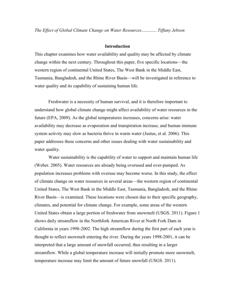
The Effect of Global Climate Change on Water Resources............. Tiffany Jebson Introduction This chapter examines how water availability and quality may be affected by climate change within the next century. Throughout this paper, five specific locations—the western region of continental United States, The West Bank in the Middle East, Tasmania, Bangladesh, and the Rhine River Basin—will be investigated in reference to water quality and its capability of sustaining human life. Freshwater is a necessity of human survival, and it is therefore important to understand how global climate change might affect availability of water resources in the future (EPA, 2009). As the global temperatures increases, concerns arise: water availability may decrease as evaporation and transpiration increase, and human immune system activity may slow as bacteria thrive in warm water (Justus, et al. 2006). This paper addresses these concerns and other issues dealing with water sustainability and water quality. Water sustainability is the capability of water to support and maintain human life (Weber. 2005). Water resources are already being overused and over-pumped. As population increases problems with overuse may become worse. In this study, the effect of climate change on water resources in several areas—the western region of continental United States, The West Bank in the Middle East, Tasmania, Bangladesh, and the Rhine River Basin—is examined. These locations were chosen due to their specific geography, climates, and potential for climate change. For example, some areas of the western United States obtain a large portion of freshwater from snowmelt (USGS. 2011). Figure 1 shows daily streamflow in the Northfork American River at North Fork Dam in California in years 1998-2002. The high streamflow during the first part of each year is thought to reflect snowmelt entering the river. During the years 1998-2001, it can be interpreted that a large amount of snowfall occurred, thus resulting in a larger streamflow. While a global temperature increase will initially promote more snowmelt, temperature increase may limit the amount of future snowfall (USGS. 2011). Figure 1. Hydrograph which shows daily mean streamflow (average streamflow for each day) for four years for the North Fork American River at North Fork Dam in California (USGS realtime streamflow data). http://ga.water.usgs.gov/edu/watercyclesnowmelt.html For the purpose of this study, water quality is defined by the physical, chemical, and biological properties of water. More specifically, water quality describes the ability of water to be ingested, to be applied agriculturally, and to be used by humans without any harmful effects—long-term or short-term. This paper will explain consequences and benefits of climate change in reference to global water resources, and it will analyze specific areas in reference to their current climate and how their water resources might change in response to changing climate. Consequences of Climate Change on Water Supply This section provides information about potential hazards and concerns regarding the impact of climate change on the availability and quality of freshwater. For example, when water quality is compromised, human health may be at risk; lack of freshwater in the form of precipitation may diminish crop yield; and, higher temperatures cause algal blooms, which may lead to areas of diminished oxygen. This section will deal specifically with issues concerning groundwater, weather patterns, algal blooms, hygiene, and pollutants. Groundwater: As climate change occurs, the water table, or the surface where the water pressure is equal to the atmospheric pressure, may lower as a temperature increase may cause clouds to retain more water. As the water table lowers to deeper levels, drinking water wells must be drilled deeper in order to access the groundwater. This may pose a problem as drilling deeper is more expensive and requires specialized equipment not readily available in some areas. In addition, deeper drinking water wells may reduce groundwater recharge. Groundwater recharge refers to the process of surface water infiltrating the surface, moving downward, and reaching the level in which the groundwater was before pumping. Groundwater recharge can be induced by humans—for example, septic system drain fields—or occur naturally via precipitation. A 15% reduction in precipitation has been shown to drastically slow groundwater recharge by as much as 40-50% (Sandstrom, 1995). Another issue, in addition to the reduction in recharge, is a potential increase in groundwater discharge. Groundwater discharge is the process of water moving upward from an aquifer to the surface or atmosphere. Similar to groundwater recharge, this process occurs either artificially or naturally. Increased groundwater discharge can be problematic, as it may cause a small rise in sea level due to the large amounts of water stored in the ground being released and eventually ending up in the ocean (Sahagian et al., 1994). Figure 2. Groundwater recharge and infiltration. http://www.wellaware.ca/pages/GroundWater.php Sea level rise, due to either an increase in groundwater discharge or melting ice caps, may affect approximately one quarter of the world’s population who live in a coastal region. These regions contain only 10% of the global renewable water supply, and an increase in high salinity water may diminish already-limited freshwater sources (Kundzewicz et al., 2007). Figure 2 shows the cycle of groundwater recharge and discharge via infiltration and percolation, or the movement of water through a medium. Another concern pertaining to drilling deeper wells is that the salinity and temperature of groundwater may increase, resulting in a lower quality of water. This is called saltwater intrusion, the movement of saline water to bodies of freshwater. Weather Patterns: An increase in temperature poses many concerns regarding the availability of freshwater for human consumption and use. Climate change may drastically alter precipitation patterns globally. For example, climate change may increase rainfall in areas of northern latitudes and the tropics, while decreasing rainfall in areas of lower–mid latitudes (CCSP, 2008). In 2011, Green et al. published a paper modeling the global changes in mean annual precipitation, evaporation, soil water content, and runoff for the years 2080–2099. It was estimated that precipitation over land would increase by about 5%, and precipitation over the ocean would increase by approximately 4%. This estimated increase in average rainfall was attributed to a proposed increase in water availability within clouds as they increase in temperature (Green et al. 2011). Similarly, average evaporation was projected to increase over the ocean with variations related to surface warming. Over terrestrial areas, rainfall changes tend to be controlled by both evapotranspiration (ET), a term used to combine total evaporation and transpiration, and runoff. Evapotranspiration is illustrated in Figure 3. For example, average Figure 3. Diagram of Evapotranspiration. http://www.westone.wa.gov.au/toolbox6/hort6/html/re sources/visitor_centre/fact_sheets/images/et.jpg runoff will decrease in southern Europe and increase in Southeast Asia and areas with high latitudes (Meehl, et al. 2007). The increase in runoff may lead to higher soil moisture content as well as unpredictable runoff patterns. As a result of this changing runoff, flooding may ensue. Flooding may cause problems in overflowing sewer systems, releasing toxins into the groundwater. Furthermore, some of these toxins may be bacterial in composition, and if allowed to flow into surface water, eutrophication, a term describing excessive nutrient content in water, may occur—promoting too much algae growth. Algal Blooms: Warmer temperatures create an environment in which algae thrives. Algal blooms will grow rapidly and deplete available oxygen in surface waters. Areas where this occurs are known as “hypoxic zones” (Osterman, 2009). Hypoxic zones occur in oxygen-depleted areas that are density stratified, usually thermally controlled, and combined with a high amount of nutrients. Neither plant nor animal life can sustain in hypoxic zones. Algal blooms may also be responsible for compromising animal health, including that of birds and fish. According to the World Health Organization, the most common ways humans are affected by algal blooms are via drinking water and recreational activities. For example, swimming in the vicinity of algal blooms may lead to accidental ingestion. Side effects of accidental ingestion are vomiting, liver disease, blistering and skin irritation. Hygiene: An increase in poor hygiene is another factor that may become a potential health hazard. Without clean water, viruses and many types of diseases may Figure 4. Map of improved water sources. (WHO, 2008.) spread rapidly. With the continual ingestion of contaminated water, immune system activity slows. Weakened immune systems, caused by contaminated water, is responsible for over two million child deaths each year (Prüss-Üstün, 2008). The World Health Organization, in partnership with UNICEF Joint Monitoring Programme, estimates that 1.1 billion people do not currently have access to clean water. If freshwater becomes less available due to climate change, more people may lose access. This is especially true in areas that lack improved water sources, or water sources that are designed to provide safe and useable water. Figure 4 shows the percentage of people per country that have access to clean water. Countries with higher population growth, such as India and China, have less access to improved water sources. Pollutants: A pollutant is defined as a substance that is present in concentrations that may harm living organisms or exceed an environmental quality standard. The term is frequently used synonymously with contaminant. The United States Environmental Protection Agency (USEPA) has put certain drinking water standards in place to inform citizens about potential pollutants. Testing parameters include nitrogen, mercury, arsenic, fecal coliform (E. Coli), and many other chemical and biological constituents. These constituents are essential to the quality assurance of water, and if consumed in amounts greater than the EPA standards, these pollutants may prove hazardous. As the amount of available groundwater decreases due to soil evaporation, pollutants that are already present in the water become more concentrated (Backlund et al. 2008). Higher concentrations of unwanted chemical constituents may lead to lower quality freshwater. In addition, using water of a different chemical composition will affect applications in which the water can be used. For example, water with a high salinity may only be used in industrial settings, as it is deemed non-potable. In addition, high salinity waters have a higher density, which may limit use in steam-driven turbines for the manufacturing of energy (Jonas. 1984). While it is clear that climate change may have negative effects on water supply and quality, in some cases climate change may improve the water supply and/or quality. As temperature increases, especially in northern latitudes characterized by snow-covered terrain, snowmelt may increase. Although a higher amount of snowmelt may increase the chance of flooding, the excess runoff may provide more water to infiltrate groundwater aquifers (Green et al. 2011). Groundwater is dominantly controlled by precipitation— rather than by temperature—making it possibly less susceptible to climate change than other water sources. Some Specific Examples Western United States: The climate in the western region of the United States shown in yellow in Figure 5—is arid to semi-arid and in some particular places, temperate. This portion of the U.S. averages approximately 400mm of annual precipitation; however, this number does vary significantly with elevation (CCPS, 2008). Average precipitation in the Western U.S. is relatively low compared to the eastern region, which averages approximately 1100 mm of precipitation annually. Figure 5. Map of Western Region of United States. http://www.mytowagent.com/images/map.gif Freshwater from this region is mainly obtained from streams that have been altered by reservoir management. Much of the runoff in this area is directly sourced from snowmelt, which may be diminished with climate change. Groundwater aquifers in this region are dependent on the type of geologic features and rock types present. For example, in the eastern section of this area, the subsurface is made up of sedimentary rocks. Generally, sedimentary rocks, such as sandstone and welljointed limestone, compose the most effective aquifers. Moving inland, the subsurface is made up of igneous and metamorphic rocks, which have visible outcrops along the Rocky Mountains. Igneous and metamorphic rocks are not usually great aquifers unless they are faulted, which creates space for groundwater to occupy. Mean annual precipitation in this area is predicted to decrease which could mean less available water in this area. An increase in temperature may also lead to the earlier melting of snow in the Rocky Mountains. Early spring streamflow of rivers in this area, may increase due to the snowmelt and average summer streamflow may decrease. Areas located along the coast may also be at risk for saltwater intrusion, an effect of lowering water table and slower recharge rates (Bates et al. 2008). The West Bank: The West Bank is located in the Middle East, near the Mediterranean Sea, as shown by Figure 6. The landscape of the West Banks can be divided into three distinct locations: the west, an area characterized by plains, the central mountainous area, and the Jordan Rift valley in the east. The climate for this area is temperate; temperature and precipitation vary with elevation, has warm to hot summers, and cool to mild winters. Although there are Figure 6. Map of the West Bank. http://israelipalestinian.procon.org/files/IsPa l%20Images/westbank.jpg three distinct regions, climate change effects will be averaged to create a single scenario for The West Bank. Droughts are the biggest natural disaster that affects the West Bank and issues with sewage treatment as well as adequacy of freshwater are problematic. Agriculture occupies 5% of cultivated land but utilizes approximately 52% of the available water resources (Mizyed. 2008). An estimated 2.3 million people live in the West Bank. The expected growth rate for the West Bank is between three and four percent. Freshwater is this area is obtained mostly from groundwater aquifers. Irrigation is prevalent in this area due to lack of surface water. The temperature increase in the West Bank is estimated to be from 1.7 to 6.5 degrees Celsius (Mizyed. 2008). From Mizyed, published in 2008, it is expected that an increase in temperature may cause a six to seven percent increase in evapotranspiration. The Sandstrom paper, published in 1995, estimates that this area may experience approximately 16% loss in precipitation that could result in as much as a 30% decrease in the groundwater recharge rate. With the location of the West Bank being in an area of political conflict, shortages in water may escalate existing tensions between different extremist groups. Tasmania, Australia: Located in the Pacific Ocean, shown by Figure 7, Tasmania is an island approximately 240 km south of mainland Australia. Tasmania has a maritime climate, meaning mild winters and warm summers with high annual rainfall. Approximately 50% of Tasmania is native vegetation, 22% is forestry, 22% is grazing, and 2% is irrigated agriculture (Post et al. 2012). The population is approximately 510,560 people and has a 0.33% growth rate. Average rainfall for Tasmania is approximately 1266mm annually. However, there is a large discrepancy between rainfall of the east and west coasts of Tasmania. The west coast usually receives approximately 4200mm of rain annually, whereas the east coast Figure 7. Map of Tasmania. http://media.web.britannica.com/eb-media/58/64358004-54829D52.gif receives only 700mm (Post et al. 2012). Using different models for climate change in Tasmania can yield very different results. According to a paper written by Post et al. in 2012, there are three distinct models used when predicting future water availability. The first model represents a wet climate and predicts a 1% increase in precipitation and a 10% increase in groundwater recharge. The second model, representing the median between wet and dry values, predicts a 2% decrease in precipitation and yields current recharge rates. The final model, representing a dry scenario predicts a 6% decrease in rainfall and a 5% decrease in groundwater recharge. Runoff for each of these scenarios will be directly related to the amount of annual precipitation, increasing with precipitation. Bangladesh: Bangladesh lies between India and Burma shown on Figure 8 in red. A humid, warm, tropical climate is characteristic of Bangladesh and is primarily influenced by monsoon cycles. Monsoon cycles are dependent upon wind circulation; air rising over heated land in summer months creates a low-pressure system then, comes in contact with a Figure 8. Map of Bangladesh. http://world.unomaha.edu/files/Image/cropped%2 0bangladesh_map.jpg cooler air mass that condenses warm air, thus creating heavy rainfall. Bangladesh is used agriculturally and approximately 85% of its population depends on these agriculture activities. Bangladesh is characterized by flat plains with occasional hills. Topography as well as geographic location make Bangladesh prone to natural disasters such as cyclones, flooding, erosion, tornadoes, droughts, and earthquakes (Agrawala et al. 2003). Approximately 151,000,000 people live in Bangladesh with a 2% growth rate (CIA World Factbook. 2012). A majority of freshwater for agriculture comes from tube wells. Tube wells are essentially what is used in the United States as groundwater monitoring wells at landfill sites. A schematic diagram of a tube well is illustrated in Figure 9. Tube wells are lined with a polyvinyl chloride (PVC) pipe and have a screened interval at the bottom portion of the well. Gravel and a type of clay called Bentonite line the well as a natural screen and deterrent for large particles. When a well is installed, it needs to be developed. This means that water must be purged from the well until it is clear. Since the well was not dewatered during installation it may contain sediment and other particulate matter. Hossain et al. published in 2011, uses current water table data and trends to model future water availability. Depth to water table may double around the year 2060. This will increase pumping costs and environmental problems may arise, which is common for deeper drilled water wells. Overuse of groundwater is occurring and pumping has already surpassed the recharge rate, therefore lowering the water table indefinitely. Figure 9. Schematic Diagram of Tube Well. http://www.fhwa.dot.gov/bridge/tunnel/pubs/nhi09010/images/ fig_15_29.gif According to Agrawala et al. 2003, cyclone frequency is modeled. Peak intensities of cyclones are predicted to increase by 5-10% and precipitation is expected to increase by about 20-30%. This will increase the risk for flooding, which Bangladesh is already prone to. Another risk for Bangladesh is sea level rise. Bangladesh is a low-lying country and any changes to sea level will greatly affect Bangaladesh. Furthermore, saltwater intrusion may also be another imminent threat. Rhine River Basin, Europe: The Rhine River, located in Western Europe, is shown in Figure 10. The Rhine River flows through seven countries and is essential for hydropower generation, agriculture, industry, and domestic water use. The Rhine River Basin is highly populated with many large cities dependent upon it. The Rhine River starts in the Swiss Alps and flows downstream towards the low-lying Netherlands. Many dams are built along the Rhine River and the swift current allows for rapid erosion. When the river reaches the Figure 10. Map of the Rhine River Valley. http://3.bp.blogspot.com/_A0lijzs4VO4/TJBVwVN7_tI/AAAA AAAAAK0/BnOdweLIrbQ/s1600/Rhine+River.jpg Netherlands, the water begins to slow, creating an environment that allows rapid sedimentation, or the settling of sediment that was suspended (Middelkoop et al. 2001). Effects from climate change vary along this vast river basin. Middelkoop et al., published in 2001, identify the effects on the Rhine River from climate change. In the alpine region of Switzerland, snow accumulation during the winter months will decrease which will increase the amount of runoff. Warmer temperatures during the summer will increase evaporation. With this increase in evaporation, this region may experience a decrease in net runoff water. In the German-middle mountains area, evapotranspiration along with precipitation determine the water availability. Evapotranspiration is estimated to overcompensate the increase in annual precipitation, therefore giving this area a net decrease in runoff water. Finally, in the lowland area of the Rhine River Basin, streamflow is estimated to increase by approximately 20% due to an increase in precipitation. During the summer months, evaporation will take up a large portion of water, possibly causing a water deficit for a given amount of time during the summer. Conclusion Using mathematical models and present examples, water sustainability due to climate change can be investigated. Advancing technology, to more efficiently clean and distribute freshwater, needs to continue in order to keep up with the growing demand of clean water. By reducing greenhouse gas emissions and humankind’s carbon footprint, the adverse effects of climate change may be impeded. More efficient water management programs need to be initiated. By looking at specific examples, effects on water resources from climate change can be better understood. The only thing that is certain is that water is vital and without it, life will not continue. Bibliography American Society for Testing and Materials. (1991) Annual Book of ASTM Standards. Designation: D5092-90 Standard Practice for Design and Installation of Groundwater Monitoring Wells in Aquifers.1081-1092. CIA. (2012) Central Intelligence Agency: Bangladesh. The World Factbook. https://www.cia.gov/library/publications/the-world-factbook/geos/bg.html Congressional Research Service (2006) Global Climate Change. CRS Issue Brief for Congress. Received through the CRS Web. http://fpc.state.gov/documents/organization/67128.pdf CORROSION. (1984) Steam turbine corrosion. http://www.steamcycle.com/steam_turbine_corrosion.pdf Emori, S., and S. J. Brown. (2005) Dynamic and thermodynamic changes in mean and extreme precipitation under changed climate, Geophys. Res. Lett., 32 Green, T., Taniguchi, M., Kooi, H., Gurdak, J., Allen, D., Hiscock, K., Treidel, H., Aureli, A. (2011) Beneath the surface of global change: Impact of climate change on groundwater. Journal of Hydrology, 405, 532-560. Hossain, A., Abustan, I., Rahman, A., Haque, A. (2011) Sustainability of Groundwater Resources in the North-Eastern Region of Bangladesh. Water Resources Management, 26, 623-641. IPCC (2007) Global Climate Projections. In: Climate Change 2007: The Physical Science Basis. Contribution of Working Group I to the Fourth Assessment Report of the Intergovernmental Panel on Climate Change. http://www.cgd.ucar.edu/ccr/knutti/papers/AR4WG1_Pub_Ch10.pdf IPCC (2008) Climate Change and Water. Technical Paper of the Intergovernmental Panel on Climate Change. http://www.ipcc.ch/pdf/technical-papers/climate-changewater-en.pdf Middelkoop, H., Daamen, K., Gellens, D., Grabs, W., Kwadijk, J., Lang, H., Parmet, B., Schadler, B., Schulla, J., Wilke, K. (2001) Impact of Climate Change on Hydrological Regimes and Water Resources Management in the Rhine Basin. Climatic Change, 49, 105–128. Mizyed, N. (2008) Impacts of Climate Change on Water Resources Availability and Agricultural Water Demand in the West Bank. Springer Science, October 31. Published Online. Organization for Economic Co-operation and Development (2003) Development and climate change in Bangladesh: Focus on coastal flooding and the sundarbans. http://www.oecd.org/dataoecd/46/55/21055658.pdf. Osterman, L., Poore, R., Swarzenski, P., Senn, D., DiMarco, S. (2009) The 20th-century development and expansion of Louisiana shelf hypoxia, Gulf of Mexico. GeoMarine Letters. 29, 405-414. P. Backlund, A. Janetos, D. Schimel, J. Hatfield, K. Boote, P. Fay, L. Hahn, C. Izaurralde, B.A. Kimball, T. Mader, J. Morgan, D. Ort, W. Polley, A. Thomson, D. Wolfe, M.G. Ryan, S.R. Archer, R. Birdsey, C. Dahm, L. Heath, J. Hicke, D. Hollinger, T. Huxman, G. Okin, R. Oren, J. Randerson, W. Schlesinger, D. Lettenmaier, D. Major, L. Poff, S. Running, L. Hansen, D. Inouye, B.P. Kelly, L. Meyerson, B. Peterson, R. Shaw. (2008) The effects of climate change on agriculture, land resources, water resources, and biodiversity in the United States. A Report by the U.S. Climate Change Science Program and the Subcommittee on Global Change Research. U.S. Department of Agriculture, Washington, DC, USA. 362, 1-242. Post, D., Chiew, F., Teng, J., Viney, N., Ling, F., Harrington, G., Crosbie, R., Graham, B., Marvanek, S., McLoughlin, R. (2012) A robust methodology for conducting large-scale assessments of current and future water availability and use: A case study in Tasmania, Australia. Journal of Hydrology, 412-413, 233-245. Sahagian, D., Schwartz, F., and Jacobs, D. (1994) Direct anthropogenic contributions to sea level rise in the twentieth century. Nature (London), 367, 54-57. Sandstrom, K. (1995) Modeling the effects of rainfall variability on groundwater recharge in semi-arid Tanzania. Nordic Hydrology, 26, 313-330. United States Geological Survey. February 25, 2012. The Water Cycle: Snowmelt Runoff. http://ga.water.usgs.gov/edu/watercyclesnowmelt.html Weber, W. (2006) Distributed optimal technology networks: an integrated concept for water reuse. Desalination, 188, 163-168. World Health Organization. (2008) Safer water, better health: costs, benefits and sustainability of interventions to protect and promote health. http://whqlibdoc.who.int/publications/2008/9789241596435_eng.pdf World Health Organization. (2012) Water-related diseases. http://www.who.int/water_sanitation_health/diseases/cyanobacteria/en/


