WMA05_Inkomati_Reservoir Sites
advertisement

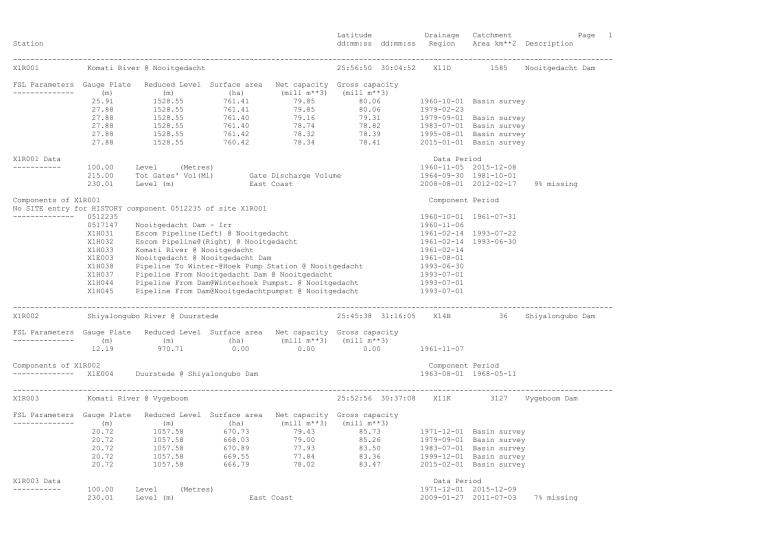
Latitude dd:mm:ss Station dd:mm:ss Drainage Region Catchment Area km**2 Page 1 Description ----------------------------------------------------------------------------------------------------------------------------------------X1R001 Komati River @ Nooitgedacht 25:56:50 30:04:52 X11D 1585 Nooitgedacht Dam FSL Parameters -------------- X1R001 Data ----------- Gauge Plate (m) 25.91 27.88 27.88 27.88 27.88 27.88 100.00 215.00 230.01 Reduced Level (m) 1528.55 1528.55 1528.55 1528.55 1528.55 1528.55 Surface area (ha) 761.41 761.41 761.40 761.40 761.42 760.42 Level (Metres) Tot Gates' Vol(Ml) Level (m) Net capacity (mill m**3) 79.85 79.85 79.16 78.74 78.32 78.34 Gross capacity (mill m**3) 80.06 80.06 79.31 78.82 78.39 78.41 Gate Discharge Volume East Coast Components of X1R001 No SITE entry for HISTORY component 0512235 of site X1R001 -------------0512235 0517147 Nooitgedacht Dam - Irr X1H031 Escom Pipeline(Left) @ Nooitgedacht X1H032 Escom Pipeline@(Right) @ Nooitgedacht X1H033 Komati River @ Nooitgedacht X1E003 Nooitgedacht @ Nooitgedacht Dam X1H038 Pipeline To Winter-@Hoek Pump Station @ Nooitgedacht X1H037 Pipeline From Nooitgedacht Dam @ Nooitgedacht X1H044 Pipeline From Dam@Winterhoek Pumpst. @ Nooitgedacht X1H045 Pipeline From Dam@Nooitgedachtpumpst @ Nooitgedacht 1960-10-01 1979-02-23 1979-09-01 1983-07-01 1995-08-01 2015-01-01 Basin survey Basin Basin Basin Basin survey survey survey survey Data Period 1960-11-05 2015-12-08 1964-09-30 1981-10-01 2008-08-01 2012-02-17 9% missing Component Period 1960-10-01 1960-11-06 1961-02-14 1961-02-14 1961-02-14 1961-08-01 1993-06-30 1993-07-01 1993-07-01 1993-07-01 1961-07-31 1993-07-22 1993-06-30 ----------------------------------------------------------------------------------------------------------------------------------------X1R002 Shiyalongubo River @ Duurstede 25:45:38 31:16:05 X14B 36 Shiyalongubo Dam FSL Parameters -------------- Gauge Plate (m) 12.19 Components of X1R002 -------------X1E004 Reduced Level (m) 970.71 Surface area (ha) 0.00 Net capacity (mill m**3) 0.00 Gross capacity (mill m**3) 0.00 1961-11-07 Component Period 1963-08-01 1968-05-11 Duurstede @ Shiyalongubo Dam ----------------------------------------------------------------------------------------------------------------------------------------X1R003 Komati River @ Vygeboom 25:52:56 30:37:08 X11K 3127 Vygeboom Dam FSL Parameters -------------- X1R003 Data ----------- Gauge Plate (m) 20.72 20.72 20.72 20.72 20.72 100.00 230.01 Reduced Level (m) 1057.58 1057.58 1057.58 1057.58 1057.58 Surface area (ha) 670.73 668.03 670.89 669.55 666.79 Level (Metres) Level (m) Net capacity (mill m**3) 79.43 79.00 77.93 77.84 78.02 East Coast Gross capacity (mill m**3) 85.73 85.26 83.50 83.36 83.47 1971-12-01 1979-09-01 1983-07-01 1999-12-01 2015-02-01 Basin Basin Basin Basin Basin survey survey survey survey survey Data Period 1971-12-01 2015-12-09 2009-01-27 2011-07-03 7% missing Latitude dd:mm:ss Station X1R003 (continued) Components of X1R003 -------------X1E006 X1H034 X1H035 X1H036 Longitude Drainage dd:mm:ss Region Catchment Area km**2 Page 2 Description Component Period 1971-10-20 1971-10-20 1971-10-20 1972-05-14 Vygeboom @ Vygeboom Dam Schoemans Canal@(Left) @ Vygeboom Bosloop Reservoir@Pipeline @ Vygeboom Komati River @ Vygeboom ----------------------------------------------------------------------------------------------------------------------------------------X1R004 Lomati River @ Schoemansdal 25:42:45 31:31:48 X14G 902 Driekoppies Dam FSL Parameters -------------X1R004 Data ----------- Gauge Plate (m) 28.50 100.00 230.09 Reduced Level (m) 328.50 Surface area (ha) 1870.00 Level (Metres) Level (m) Net capacity (mill m**3) 250.92 Gross capacity (mill m**3) 251.00 1997-12-17 Basin survey Data Period 1997-12-17 2015-11-24 2011-05-12 2011-08-03 4 Water Cello 1% missing ----------------------------------------------------------------------------------------------------------------------------------------X1R005 Komati River @ Pigg's Peak 26:04:32 31:15:39 X13E 1042 Maguga Dam FSL Parameters -------------- Gauge Plate (m) 90.00 Reduced Level (m) 626.00 Surface area (ha) 1049.10 Net capacity (mill m**3) 333.75 Gross capacity (mill m**3) 333.95 2006-04-01 Basin survey ----------------------------------------------------------------------------------------------------------------------------------------X2R001 Wit River @ Klipkopje 25:16:47 31:00:03 X22G 106 Longmere Dam FSL Parameters -------------- X2R001 Data ----------- Gauge Plate (m) 10.63 10.63 10.63 100.00 Components of X2R001 -------------X2H065 X2H073 0555794 X2E001 X2E011 X2E012 Reduced Level (m) 919.68 919.68 919.71 Level Surface area (ha) 93.86 93.35 94.00 Net capacity (mill m**3) 4.35 4.19 4.20 Gross capacity (mill m**3) 4.43 4.23 4.24 1942-03-26 1979-10-02 1990-10-01 Basin survey Basin survey Basin survey Data Period 1942-04-01 2015-11-26 (Metres) Component 1942-03-26 1945-03-05 1959-10-21 1959-10-21 1973-05-01 1993-03-01 Wit River @ Klipkopje Left Canal From Wit River @ Klipkopje Bultfontein - Bos Nelspruit Friedenheim @ Nelspruit Primkop @ Primkop Dam 1% missing Period 1952-04-13 1973-05-31 1973-04-30 1993-02-28 ----------------------------------------------------------------------------------------------------------------------------------------X2R002 Wit River @ Klipkopje 25:13:13 31:00:26 X22G 76 Klipkopjes Dam FSL Parameters -------------- Gauge Plate (m) 10.67 10.67 10.67 Reduced Level (m) 942.21 942.21 942.21 Surface area (ha) 233.50 233.50 233.50 Net capacity (mill m**3) 12.16 11.87 11.78 Gross capacity (mill m**3) 12.56 12.19 12.05 1959-10-21 1979-10-01 1990-10-01 Basin survey Basin survey Basin survey Latitude dd:mm:ss Station X2R002 (continued) X2R002 Data ----------100.00 Level Components of X2R002 -------------0555794 X2E001 X2H066 X2E011 X2E012 Bultfontein - Bos Nelspruit Wit River @ Klipkopje Friedenheim @ Nelspruit Primkop @ Primkop Dam Longitude Drainage dd:mm:ss Region Catchment Area km**2 Page 3 Description Data Period 1959-10-21 2015-11-26 (Metres) Component 1959-10-21 1959-10-21 1970-02-23 1973-06-01 1993-03-01 Period 1973-04-30 1973-05-31 1993-02-28 ----------------------------------------------------------------------------------------------------------------------------------------X2R003 Sand River @ Witklip Forest Res. 25:14:11 30:53:58 X22E 64 Witklip Dam FSL Parameters -------------- X2R003 Data ----------- Gauge Plate (m) 13.72 13.72 13.72 13.72 100.00 230.01 Components of X2R003 -------------X3E002 X2H068 X2H067 X2E010 X2H069 Reduced Level (m) 1006.92 1006.92 1006.92 1006.92 Surface area (ha) 188.11 188.31 187.80 187.52 Level (Metres) Level (m) Net capacity (mill m**3) 12.80 12.60 12.40 12.52 Gross capacity (mill m**3) 12.97 12.73 12.52 12.64 1969-05-01 1979-08-01 1990-09-01 2002-06-01 Basin Basin Basin Basin survey survey survey survey Data Period 1969-05-01 2015-11-26 2010-07-02 2011-05-11 East Coast Component Period 1969-05-01 1970-04-30 1969-11-27 1970-05-06 1970-06-01 1977-07-27 Burgershall @ Research Station Sand River @ Witklip Forest Res. Left Canal From Dam @ Witklip Forest Res. Witklip Forest Res @ Witklip Dam Right Pipeline From Dam @ Witklip Forest Res. ----------------------------------------------------------------------------------------------------------------------------------------X2R004 Wit River @ Primkop 25:23:08 31:04:15 X22H 262 Primkop Dam FSL Parameters -------------- X2R004 Data ----------- Gauge Plate (m) 10.50 10.50 10.50 10.50 10.50 100.00 149.00 Components of X2R004 -------------X2E010 0556020 X2E012 Reduced Level (m) 728.90 728.90 728.90 728.90 728.90 Surface area (ha) 41.50 41.50 41.30 40.70 40.70 Net capacity (mill m**3) 2.09 2.09 2.02 1.96 1.90 Gross capacity (mill m**3) 2.21 2.21 2.09 2.02 1.93 1970-10-22 1971-03-01 1979-10-01 1987-10-01 1999-10-01 Basin Basin Basin Basin Basin survey survey survey survey survey Level (Metres) Combined (cumecs) Data Period 1970-10-22 2015-11-26 1981-04-24 1998-10-03 Witklip Forest Res @ Witklip Dam White River - Mun Primkop @ Primkop Dam Component Period 1971-03-01 1973-09-30 1973-10-01 1973-10-01 2% missing 2% missing Latitude dd:mm:ss Station dd:mm:ss Drainage Region Catchment Area km**2 Page 4 Description ----------------------------------------------------------------------------------------------------------------------------------------X2R005 Krokodil River @ Badfontein 25:21:37 30:23:12 X21D 954 Kwena Dam FSL Parameters -------------- X2R005 Data ----------- Gauge Plate (m) 36.50 36.50 100.00 230.01 230.03 Components of X2R005 -------------X2E013 X2H070 Reduced Level (m) 1183.00 1183.00 Surface area (ha) 1259.64 1250.40 Level (Metres) Level (m) Level (m) Net capacity (mill m**3) 160.51 158.89 Gross capacity (mill m**3) 160.66 158.93 1983-12-01 1999-10-01 Basin survey Basin survey Data Period 1985-12-12 2016-01-19 2008-01-16 2011-04-13 2007-03-23 2007-05-18 East Coast ProDesign GPRS Component Period 1983-09-22 1983-09-22 Elandspruit @ Kwena Dam Krokodil River @ Badfontein ----------------------------------------------------------------------------------------------------------------------------------------X3R001 White Waters River @ Etna 25:08:31 31:01:14 X31H 61 Da Gama Dam FSL Parameters -------------- X3R001 Data ----------- Gauge Plate (m) 20.42 20.42 20.42 20.42 100.00 230.09 Components of X3R001 -------------X3H020 X3E004 X3H019 Reduced Level (m) 873.26 873.26 873.26 873.26 Surface area (ha) 130.00 129.80 130.00 128.89 Level (Metres) Level (m) Net capacity (mill m**3) 13.73 13.59 13.47 13.53 Gross capacity (mill m**3) 13.88 13.65 13.52 13.58 1972-07-26 1979-10-01 1990-10-01 2002-10-01 Basin Basin Basin Basin survey survey survey survey Data Period 1972-07-26 2016-01-21 2010-06-23 2011-05-20 4 Water Cello 1% missing 25% missing Component Period 1973-01-27 1973-05-01 1977-07-01 White Waters River @ Etna Etna @ Da Gama Dam Right Canal From Dam @ Etna ----------------------------------------------------------------------------------------------------------------------------------------X3R002 Marite River @ Inyaka 24:53:06 31:05:04 X31G 211 Inyaka Dam FSL Parameters -------------- X3R002 Data ----------- Gauge Plate (m) 34.89 34.89 100.00 230.01 230.04 Reduced Level (m) 768.60 768.60 Surface area (ha) 795.00 811.10 Level (Metres) Level (m) Level (m) Net capacity (mill m**3) 121.18 123.66 East Coast HYDRAS 3 Gross capacity (mill m**3) 125.35 125.03 2002-04-15 2002-10-01 Basin survey Basin survey Data Period 2002-05-16 2015-11-17 2010-07-06 2011-05-19 2005-05-26 2010-03-16 1% missing 15% missing Da Gama Dam Driekoppies Dam Inyaka Dam Klipkopjes Dam Kwena Dam Longmere Dam Maguga Dam Nooitgedacht Dam Primkop Dam Shiyalongubo Dam Vygeboom Dam Witklip Dam 4 2 4 2 4 2 2 1 3 1 1 3
