CLOMR - Southeast Metro Stormwater Authority
advertisement
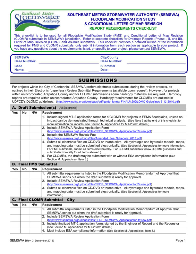
SOUTHEAST METRO STORMWATER AUTHORITY (SEMSWA) FLOODPLAIN MODIFICATION STUDY & CONDITIONAL LETTER OF MAP REVISION REPORT REQUIREMENTS CHECKLIST This checklist is to be used for all Floodplain Modification Study (FMS) and Conditional Letter of Map Revision (CLOMR) submittals in SEMSWA’s jurisdiction. Refer to separate checklists for Drainage Reports (Phase I, II, and III), Letter of Map Revision (LOMR), and As-Built submittals. This checklist provides a detailed outline of the information required for FMS and CLOMR submittals; only submit information from each section as applicable to your project. If you have any questions about the requirements listed, or specific to your project, please contact SEMSWA. SEMSWA Case Number: City/County Case Number: Case Name: Submittal Date: SUBMISSIONS For projects within the City of Centennial, SESMWA prefers electronic submissions during the review process, as outlined in their Electronic (paperless) Review Submittal Requirements (available upon request). However, for projects within unincorporated Arapahoe County and for CLOMR submissions some hardcopy materials are required. Hardcopy reports are required within unincorporated Arapahoe County. Hardcopy requirements for CLOMRs are outlined in UDFCD’s DLOMC guidelines. (http://www.udfcd.org/downloads/pdf/guide_forms/ FINAL%20DLOMC-Guidelines-5-13-2010.pdf) A. Draft Submission(s) (All Electronic) Yes No N/A Requirement 1. Include signed MT-2 application forms for a CLOMR for projects in FEMA floodplains, unless no impact can be demonstrated through technical analysis. (See Note 3 at the end of this checklist for more information on impacts; see Section M. Appendices for MT-2 form details.) 2. Include SEMSWA Review Application Form (http://www.semswa.org/uploads/files/FPDP_SEMSWA_ApplicationforReview.pdf) 3. Include the SEMSWA Review Fee (http://www.semswa.org/uploads/files/Amended_Fee_Schedule_2013.pdf) 4. Submit all electronic files on CD/DVD or thumb drive. All hydrologic and hydraulic models, maps, and mapping data must be submitted electronically. (See Section M. Appendices for more information. For FMS submittals, submit all items electronically. For CLOMR submittals follow DLOMC guidelines and submit electronically for all items allowed.) 5. For CLOMRs, the draft may be submitted with or without ESA compliance information (See Section M. Appendices, Item 3.) B. Final FMS Submittal Yes No N/A Requirement 1. All submittal requirements listed in the Floodplain Modification Memorandum of Approval that SEMSWA sends out when the draft submittal is ready for approval. 2. Include SEMSWA Review Application Form (http://www.semswa.org/uploads/files/FPDP_SEMSWA_ApplicationforReview.pdf) 3. Submit all electronic files on CD/DVD or thumb drive. All hydrologic and hydraulic models, maps, and mapping data must be submitted electronically. (See Section M. Appendices for more information.) C. Final CLOMR Submittal – City Yes No N/A Requirement 1. All submittal requirements listed in the Floodplain Modification Memorandum of Approval that SEMSWA sends out when the draft submittal is ready for approval. 2. Include SEMSWA Review Application Form (http://www.semswa.org/uploads/files/FPDP_SEMSWA_ApplicationforReview.pdf) 3. Include finalized MT-2 application forms signed by the Engineer of Record and the Requestor (see Section M. Appendices for MT-2 form details.) 4. Must include ESA compliance information (See Section M. Appendices, Item 3.) SEMSWA (Rev. 3, December 2013) Page 1 FMS & CLOMR REPORT CHECKLIST SEMSWA Case Number: Yes No N/A Requirement 5. Three (3) copies following electronic submittal and DLOMC guidelines (2 will be sent to FEMA/UDFCD for review, 1 SEMSWA will retain for filing) 6. Submit all electronic files on CD/DVD or thumb drive. All hydrologic and hydraulic models, maps, and mapping data must be submitted electronically. (See Section M. Appendices and the DLOMC guidelines for more information.) D. Final CLOMR Submittal – County Yes No N/A Requirement 1. All submittal requirements listed in the Floodplain Modification Memorandum of Approval that SEMSWA sends out when the draft submittal is ready for approval. 2. Include SEMSWA Review Application Form (http://www.semswa.org/uploads/files/FPDP_SEMSWA_ApplicationforReview.pdf) 3. Include finalized MT-2 application forms signed by the Engineer of Record and the Requestor. There must be a copy of Form 1 signed by each affected community. (See Section M. Appendices, Item 1 for MT-2 form details.) 4. Must include ESA compliance information (See Section XIV. Appendices, Item C for more information.) 5. Four (4) copies. 2 full hard copies and 2 copies following DLOMC guidelines. (The DLOMC copies will be sent to FEMA/UDFCD for review, 1 each of the hard copies will be retained for filing by SEMSWA and the County. ) 6. Submit all electronic files on CD/DVD or thumb drive. All hydrologic and hydraulic models, maps, and mapping data must be submitted electronically. (See Section M. Appendices and the DLOMC guidelines for more information.) E. Final CLOMR Submittal – FEMA/UDFCD (SEMSWA staff will submit CLOMR to FEMA/UDFCD) Yes No N/A Requirement 1. Consultant to submit FEMA review fee, except for CIP projects. (Verify the correct fee on FEMA’s website at: http://www.fema.gov/plan/prevent/fhm/frm_fees.shtm. Obtain fee from project owner/developer. For CIP projects, the fee may come from SEMSWA, City, County or be paid by consultant as negotiated in the approved scope of work for the project.) 2. For CIP projects, the fee may come from SEMSWA, City, County or be paid by consultant as negotiated in the approved scope of work for the project. Verify the requirement with SEMSWA. F. Final Data Yes No N/A Requirement 1. Provide any changes made to the submitted information after issuance of an approval by SEMSWA, for SEMSWA’s records. (For example, when additional data has been submitted in response to an AD letter from FEMA.) 2. Provide final 100-year floodplain delineations and cross section cutlines to SEMSWA in GIS format. Also provide final 0.5 ft. floodway delineations, 500-year floodplain delineations and BFEs, in GIS format. REPORT REQUIREMENTS A. General Yes No N/A Requirement 1. Within each section, discuss all tables, figures, charts, drawings, etc. that were used and describe the information included in the appendix of the report that is relevant to that section. 2. Include a descriptive file name on all model files. 3. Include a description within the model files. (Include who, what, why, version, and vertical datum.) B. Title Page Yes No N/A Requirement SEMSWA (Rev. 3, December 2013) Page 2 FMS & CLOMR REPORT CHECKLIST SEMSWA Case Number: 1. Name of Project Yes No N/A Requirement 2. Address 3. Property Owner & Property Jurisdiction 4. Developer/Project Owner 5. Engineer 6. Submittal date and revision dates, as applicable C. Certification Statement Yes No N/A Requirement Include a Certification Statement page, signed and stamped by the responsible Professional Engineer, registered in the State of Colorado. (Example statement at http://www.semswa.org/uploads/files/Engineer_s_Certification_Statement.pdf) D. Introduction Yes No N/A Requirement 1. Project Background A. Purpose B. Background & Previous Projects 2. Project Location A. Project Vicinity Map B. Township, Range, Section, and ¼ Section or River Stations, and Latitude & Longitude (Latitude & Longitude needed for USACE permits) C. Affected Jurisdictions & Districts D. Streets, Roadways, and Highways adjacent to the proposed development, or within the area served by the proposed improvements E. Names of surrounding or adjacent developments, including land use or zoning information 3. Project Area Description A. Project Type & Extent B. Discuss characteristics of proposed project (e.g. fill limits, channel design characteristics, etc.) C. Affected Area (stream miles and/or site acres) D. Ground cover, vegetation, site topography and slopes E. NRCS Soils Classification Map and discussion F. Major and minor drainageways G. Existing irrigation canals or ditches H. Significant geologic features 4. Floodplain A. Unmapped Floodplain – Summarize resources and methodology used for delineation of the floodplain. B. Mapped Floodplain – Discuss the source of the floodplain information and level of detail: - UDFCD Flood Hazard Area Delineation (FHAD) Report, Development Plan, etc. AND/OR - Digital Flood Insurance Rate Map (DFIRM) C. Summarize proposed floodplain modifications, including level of encroachment, velocities, depths, stabilization measures, water surface elevations, etc. 5. Study Limits A. Upstream Tie-in Location B. Downstream Tie-in Location SEMSWA (Rev. 3, December 2013) Page 3 FMS & CLOMR REPORT CHECKLIST SEMSWA Case Number: E. Analysis Criteria Yes No N/A 1. Regulations Requirement A. County and/or City criteria, when applicable - Floodplain Development Permit requirements - Floodplain Modification Study requirements - Conditional Letter of Map Revision (CLOMR) requirements B. UDFCD criteria and optional provisions, when applicable C. CWCB criteria, when applicable D. FEMA criteria, when applicable E. Other criteria (e.g. CDOT, etc.) 2. Drainage Studies, Master Plans, Site Constraints A. Discuss previous drainage studies or master plans for the site or project that influence the site design and/or floodplain analysis. B. Discuss floodplain impacts from adjacent developments and how that affects the project design and/or floodplain analysis. C. Discuss UDFCD Outfall Systems Plans, Master Drainageway Plans, and/or Stabilization Plans and how recommendations in those studies affect the site design and/or floodplain analysis. D. Discuss impacts to the project and floodplain analysis, caused by constraints, such as streets, utilities, light rail rapid transit, existing structures, etc. 3. Additional Permitting Requirements A. Compliance with Section 404 of the Clean Water Act (e.g. USACE 404 Permit) B. Grading, Erosion, and Sediment Control (GESC) C. UDFCD Maintenance Eligibility Review D. Compliance with the Endangered Species Act (See Section M. Appendices, Item 3 for more information) E. Other local, State, or Federal requirements, including but not limited to: - South Suburban Parks and Recreation District State Dewatering Permit Right of Way Permit Fence Permit No-Rise Certification (for submittals for No Impact Floodplain Development Permits) F. Topographic Mapping Discussion Yes No N/A 1. Existing Data Requirement A. B. C. D. Discuss source Discuss contour interval Describe any benchmarks used for survey Discuss vertical & horizontal datum (All mapping and elevations must be reported in NAVD88 & NAD83. If the original source data are not in these datums, they must be converted. See Item F.3 for reporting of vertical datum conversion, if needed.) E. Discuss coordinate projection system (e.g. State Plane, UTM, Modified State Plane, etc.) F. If a modified, truncated, or local projection system is used, discuss the source of the projection system G. Provide equation(s) for conversion to SEMSWA’s standard projection (NAD_1983_StatePlane_Colorado_Central_FIPS_ 0502_Feet), as needed 2. Proposed Topography/Grading A. Discuss source B. Discuss contour interval SEMSWA (Rev. 3, December 2013) Page 4 FMS & CLOMR REPORT CHECKLIST SEMSWA Case Number: Yes No N/A Requirement C. Describe any benchmarks used for survey D. Discuss vertical & horizontal datum (All mapping and elevations must be reported in NAVD88 & NAD83. If the original source data are not in these datums, they must be converted. See Item F.3 for reporting of vertical datum conversion, if needed.) E. Discuss coordinate projection system (e.g. State Plane, UTM, Modified State Plane, etc.) F. If a modified, truncated, or local projection system is used, discuss the source of the projection system G. Provide equation(s) for conversion to SEMSWA’s standard projection (NAD_1983_StatePlane_Colorado_Central_FIPS_ 0502_Feet), as needed 3. Vertical Datum Conversion, as applicable A. Discuss source (Only Vertcon or Corpscon are accepted.) B. Provide equation defining conversion (e.g. NGVD29 + X.XX = NAVD88.) G. Hydrology Yes No N/A Requirement 1. FEMA FIS Flows (if using FEMA flows) A. Discuss source of flows from FIS report B. Provide table summarizing FEMA FIS flows 2. Peak Flows (from UDFCD MDP, FHAD, or Outfall Systems Plan) A. Discuss source of peak flows used B. Design storm recurrence intervals 3. Hydrologic Analysis, if applicable (i.e., hydrology is new or changed from published values) A. On-site and off-site major drainage basin characteristics and flow patterns and paths B. Existing and proposed land uses within the basins C. Calculation method(s), including version/build (e.g. CUHP 2005, EPASWMM 5.0 Build 5.0.022, HECHMS 3.5) D. Design rainfall E. Input Parameters F. Provide summary output table H. Hydraulics Yes No N/A Requirement 1. Analysis Method A. Describe analysis method used, including version (e.g. HEC-RAS 4.1.0) B. Discuss specific application of method for study (e.g., steady-state, subcritical flow) C. Describe models submitted: 2. Input Parameters A. B. C. D. E. Duplicate Effective (required) Corrected Effective, as applicable Existing Conditions, as applicable Proposed Conditions (required) Discuss Boundary Conditions Discuss Manning’s Roughness Coefficients (n-values) Discuss Contraction/Expansion Coefficients Discuss Flow Controls (Ineffective flow areas, levee points, etc.) Provide a table(s) summarizing items A-D SEMSWA (Rev. 3, December 2013) Page 5 FMS & CLOMR REPORT CHECKLIST SEMSWA Case Number: Yes No N/A Requirement F. Provide a table correlating stream stationing and cross section ID, as applicable. (If cross section ID is not based on stream stationing, or if stationing is not consistent between submitted models (e.g. for a channel modification project), correlate the cross section ID and/or stream stationing between all models submitted, and if necessary, the effective floodplain mapping.) 3. 0.5 Foot Floodway Analysis, as applicable (If there is an existing floodway determined, a floodway model must be submitted even if the analysis shows the floodway to be coincident with the 100-year floodplain). A. Discuss encroachment method(s) used B. Describe any modifications to the floodway encroachment analysis as compared to the effective floodway encroachment analysis. C. Describe any variances from surcharge criteria (0.50 ft. ≥ surcharge criteria ≥ 0.00 ft.) (Address any negative surcharges, etc.) D. Provide a Floodway Data Table summarizing floodway data by cross section, including: - Water-surface elevations Floodway top width (Calculate from floodway encroachment stations; do not use HEC-RAS output.) Flow area Velocity Computed surcharge 4. Results A. Discuss floodplain impacts from the existing conditions, proposed project, etc. B. Provide summary output tables for each submitted model, including: - 100- and 500-year analyses (required at a minimum) - Multiple Profile analysis (10-, 50-, 100-, & 500-year events, i.e. the same profiles as shown in the effective FIS) - 0.5 Foot Floodway analysis, as applicable C. Provide an overall comparison table. (Include quantitative comparisons of the following data from each submitted model. Include all cross section locations from each submitted analysis. Interpolate as needed to provide comparison values at every location. Indicate interpolated values with shading, bold text, or some other means. See template at http://www.semswa.org/uploads/files/ComparisonTable_Template.xls.) - Water-surface elevations Floodplain top width Velocity Hydraulic Depth (Channel) I. Sediment Transport & Fluvial Morphology (Only if applicable. CLOMRs require an explanation as to why, if not applicable.) Yes No N/A Requirement 1. Analysis Method A. Describe analysis method used, including version (e.g. HEC-RAS 4.1.0) B. Discuss specific application of method for study C. Describe models submitted: - Existing Conditions - Proposed Conditions 2. Input Parameters A. B. 3. Results A. B. Discuss analysis inputs Provide a table summarizing input data Discuss impacts due to existing conditions, proposed project, etc. Provide summary output tables for each submitted model SEMSWA (Rev. 3, December 2013) Page 6 FMS & CLOMR REPORT CHECKLIST SEMSWA Case Number: J. Floodplain Mapping Discussion Yes No N/A Requirement 1. Existing Conditions Mapping A. Describe method used to delineate floodplain and/or floodway boundaries B. Describe any changes in floodplain and/or floodway boundaries shown on the map as compared to effective and corrected effective boundaries, as applicable 2. Proposed Conditions Mapping A. Describe method used to delineate floodplain and/or floodway boundaries, if different from method used for Existing Conditions B. Describe any changes in floodplain and/or floodway boundaries shown on the map as compared to existing conditions and effective boundaries, as applicable K. Conclusions Yes No N/A Requirement 1. Compliance with Standards A. Arapahoe County and/or City of Centennial criteria B. UDFCD criteria C. CWCB criteria, as applicable D. NFIP Regulatory Requirements (See details on MT-2 Form 2) - Compliance with Section 65.12 of the NFIP regulations - Certification re: local ordinances & reasonably safe from flooding - Potential for impact on endangered species E. Master Drainage Plans 2. Variances to Floodplain Criteria, if applicable A. Identify provisions by section number for which a variance will be requested or has been approved by SEMSWA, or the City or County B. Provide justification for each variance requested 3. Impacts to Adjacent Properties A. Discuss any potential impacts to adjacent properties (For CLOMRs, impacts are determined by comparing the Proposed Conditions model with either the Existing Conditions or Effective model. See Note 3 for definition of “impact.”) B. Discuss measures proposed to mitigate potential impacts, if applicable C. For CLOMRs, discuss impact notification requirements and compliance therewith (See Section XIV. Appendices, Item B.3 for more information.) L. References Yes No N/A Requirement Include reference citations for all criteria, master drainage plans, reports, or other technical information used in development of the concepts discussed in the study report M. Appendices Yes No N/A Requirement 1. Appendix A – Photos (May submit electronic or hard copies per DLOMC guidelines.) A. Project Area Photos 2. Appendix B – FEMA’s MT-2 Application Forms, as applicable (Hardcopies required per DLOMC guidelines) A. Provide a copy of Form 1 for every jurisdiction impacted by the change in flood hazard, including all impacted jurisdictions outside of SEMSWA’s boundary, such as Aurora, Denver, and/or Douglas County. (Every impacted community needs to sign a copy of Form 1. Requestor and Engineer of Record signatures should be completed. The Requestor should be the primary point-of-contact for the project who receives project correspondence. This can be the project owner, developer, consultant, etc. This may be the SEMSWA Project Manager for SEMSWA CIP projects.) SEMSWA (Rev. 3, December 2013) Page 7 FMS & CLOMR REPORT CHECKLIST SEMSWA Case Number: Yes No N/A Requirement B. Complete Section D (Common Regulatory Requirements) of Form 2. C. Forms 3-6, as applicable. (Provide only those forms that apply to the project. For Form 3, only provide those pages of the form that are applicable to the project, e.g. there is no need to submit the levee forms if the project does not include levees.) D. Copies of Impact Notification Letters sent to each property owner impacted by the modified floodplain/floodway or a sample letter and a list of affected property owners, listed by parcel number. (May submit electronic or hard copies per DLOMC guidelines. See the MT-2 Instructions for letter requirements and examples. SEMSWA prefers not to provide notification through newspaper notices. SEMSWA prefers that each property owner be provided individual notification for all impacts (e.g. both floodplain and floodway) in a single letter. Include a property-specific map showing the impacts. Submit the letters to SEMSWA on CD/DVD for review with draft submission. For CIP projects, the consultant will prepare the letters for signature by the SEMSWA Floodplain Program Manager. For non-CIP projects, the consultant or project owner should sign the letters. Include digital copies (PDFs) of the executed letters in the submittal. The consultant is responsible for mailing all notification letters, even those signed by SEMSWA.) E. Certification of Impact Notification. (The consultant’s responsible professional engineer must provide certification that all impacted property owners have been individually notified of the impacts to their properties. For projects in the FEMA regulatory floodway, include certification that no structures are impacted.) 3. Appendix C – Endangered Species Act (ESA) Compliance for CLOMRs (See FEMA Procedure Memorandum 64 at: http://www.fema.gov/library/viewRecord.do?id=4312. Submit one of the following documents from the U.S. Fish and Wildlife Service (USFWS), as applicable. May submit electronic or hard copies per DLOMC guidelines.) A. B. C. D. Incidental Take Permit Incidental Take Statement “Not Likely to Adversely Affect” determination “No Effect” letter, where USFWS concurs that the project has no effect on proposed or listed species or designated critical habitat. 4. Appendix D – Effective Floodplain Information (May submit electronic or hard copies per DLOMC guidelines.) A. Effective Map (DFIRM or FHAD) B. FIS Report information, as applicable - Summary of Discharges Table - Floodway Data Table - Profile 5. Appendix E – Hydrologic Reference Data (if using published flows from a FHAD or Master Drainage Plan, or other non-FIS source, etc.) OR Hydrologic Computations (if submitting new analysis) (May submit electronic or hard copies per DLOMC guidelines, except for model files which MUST be submitted electronically.) A. If using published flows from a FHAD, Master Drainage Plan, etc., submit the following: - Submit copies of the applicable tables, graphs, and profiles. - Submit electronic copies of the applicable analyses (CUHP, SWMM, etc., per recent UDFCD requests) B. If submitting new analysis, provide the following: - Determination of runoff coefficients and times of concentration Land use assumptions for off-site areas Other input parameter determinations (curve numbers, routing elements, etc.) Peak flow rate calculations Rainfall information Model input and output (electronic copies of any executable files needed to run the model, input and output files in PDF format) - Hydrograph data, if applicable - Connectivity diagram showing relationship/connectivity of basins, conveyance facilities, detention ponds, and design points SEMSWA (Rev. 3, December 2013) Page 8 FMS & CLOMR REPORT CHECKLIST SEMSWA Case Number: Yes No N/A Requirement - Basin Map, including design point summary 6. Appendix F – Hydraulic Computations (Provide information for all models submitted. May submit electronic or hard copies per DLOMC guidelines, except for model files which MUST be submitted electronically.) A. Manning’s n determination, if applicable B. Executable electronic files for all submitted models C. Cross section and profile outputs (graphs), with water surface elevations, for all submitted models 7. Appendix G – Plans & Work Maps (See Exhibits Checklist for details. Items marked “Digital optional” may be submitted electronically or hard copy, per DLOMC guidelines. Work maps MUST be submitted BOTH electronically [shapefiles or geodatabase] and hard copy, per DLOMC guidelines.) A. Design and grading plans for proposed project (Digital optional) B. Overall Drainage plan, as applicable (Digital optional) C. Comparison work map, showing effective, existing & proposed conditions (Required) D. Existing Conditions Floodplain work map (If needed to provide a clear understanding of impacts, e.g. when there are Effective, Corrected Effective, and Existing Conditions models.) E. Provide completed mapping agreement table for each map submitted. (See sample table in UDFCD DLOMC Guidelines, or at http://www.udfcd.org/downloads/down_guide_forms.htm Digital Optional.) F. Water surface elevation profiles for all submitted models (Digital optional) G. Annotated DFIRM, as applicable (Hard copy required, per DLOMC guidelines.) H. Annotated Profile, as applicable (Digital optional) I. Annotated Floodway Data Table, as applicable (Digital optional) 8. Appendix H – Referenced Information (May submit electronic or hard copies per DLOMC guidelines.) A. Copies of pertinent portions of all referenced materials, if not already included elsewhere in the appendices. Notes: 1. Floodplain Modification Study reports may be stand-alone documents or they may be incorporated into other submittals, such as Drainage and/or Design Reports. 2. SEMSWA, the City, and County require a CLOMR submittal for any project that impacts a FEMA-designated floodplain (Special Flood Hazard Area) unless it can be demonstrated, through technical analysis, that there is no impact to the floodplain from the proposed project. (See SEMSWA Manual at Section 5.12.4(2) and County Manual at Section 5.12.2) 3. An impact to the floodplain is defined as: a. An increase in the 100-year water surface elevation (BFE). An increase in BFE is any increase (i.e., any rise over 0.00 ft.). b. An increase in width and/or shift of the floodplain boundary. 4. Decreases in BFE are considered impacts if they are equal to or greater than 0.3 ft., as provided for in the Colorado State Floodplain Regulations. 5. There is no distinction in the level of analysis and/or submittal requirements for projects that are proposed in: a. A floodplain with no defined floodway b. A floodplain with a defined floodway c. The floodplain fringe. d. Unmapped floodplains SEMSWA (Rev. 3, December 2013) Page 9 SOUTHEAST METRO STORMWATER AUTHORITY (SEMSWA) FLOODPLAIN MODIFICATION STUDY & CONDITIONAL LETTER OF MAP REVISION EXHIBIT REQUIREMENTS CHECKLIST This checklist is to be used to prepare exhibits for all Floodplain Modification Study (FMS) and Conditional Letter of Map Revision (CLOMR) submittals in SEMSWA’s jurisdiction. Refer to separate checklists for Drainage Report, Letter of Map Revision (LOMR), and As-Built exhibits. This checklist provides a detailed outline of the information required for FMS and CLOMR exhibits; only submit information from each section as applicable to your project. Submitted plans must follow the requirements listed in the Land Development Plan Checklist, which is available upon request. If you have any questions about the requirements listed, or specific to your project, please contact SEMSWA. SEMSWA Case Number: City/County Case Number: Case Name: Submittal Date: EXHIBIT REQUIREMENTS A. Drainage Plan (Only if submitting new hydrology. May submit electronic or hard copies per DLOMC guidelines.) Yes No N/A Requirement 1. 24” x 36” in size for SEMSWA, 22” x 34” for the County (22” x 34” also acceptable for SEMSWA when half size sets will be produced) 2. 3. 4. 5. 6. 7. 8. 9. Title block and legend, submittal date & revisions, if applicable Show boundaries of entire development or project Existing or proposed streets, roadways, or highways Show limits of all major basins, including off-site basins where feasible Jurisdictional boundaries (Required) Topographic information Overlay or figure showing layout of Project Plan sheets Engineer’s Certification Statement, signed & stamped (Example statement at http://www.semswa.org/uploads/files/Engineer_s_Certification_Statement.pdf) B. Project Grading Plans (May submit electronic or hard copies per DLOMC guidelines.) Yes No N/A Requirement 1. 24” x 36” in size for SEMSWA, 22” x 34” for the County (22” x 34” also acceptable for SEMSWA when half size sets will be produced, may submit half-size copies during the review process) 2. Title block and legend, submittal date & revisions, if applicable 3. Basin designations, design points, flow rates, volumes, release rates, consistent with City and/or County standards (Only if submitting new hydrology.) 4. Scale 1”= 20’ to 1”= 100’, as required to show sufficient detail 5. Vertical datum (e.g., NAVD88) 6. Horizontal datum and spatial projection (e.g., NAD83 & State Plane) 7. Date of aerial photography or survey 8. Existing (dashed or screened) and proposed (solid) contours with a maximum contour interval of 2 feet. In terrain where the slope exceeds 15%, the maximum interval is 5 feet. Contours must extend a minimum of 100 feet beyond property lines. 9. Existing utilities and structures 10. All jurisdictional and property boundaries and easements with type of easements noted 11. Adjacent developments or ownerships 12. Location and elevation of all existing and proposed 100-year floodplain boundaries, including the source of designation. All floodplain designations that exist for the site should be included, i.e. FEMA FIS/DFIRM, FHAD, and others. 13. Summary Discharge Table, shown on the applicable plan sheet (Only if submitting new hydrology.) SEMSWA (Rev. 3, December 2013) Page 1 FMS & CLOMR EXHIBITS CHECKLIST SEMSWA Case Number: Yes No N/A Requirement 14. Engineer’s Certification Statement, signed & stamped (Example statement at http://www.semswa.org/uploads/files/Engineer_s_Certification_Statement.pdf) C. Comparison Floodplain Work Map (Required) (MUST be submitted BOTH electronically [shapefiles or geodatabase] and hard copy, per DLOMC guidelines.) Yes No N/A Requirement 1. Page Setup and Title Block A. 24” x 36” in size for SEMSWA, 22” x 34” for the County (22” x 34” also acceptable when half size sets will be produced) B. C. D. E. F. G. Title block and legend, submittal date & revisions, if applicable Scale 1”= 20’ to 1”= 100’, as required to show sufficient detail Vertical datum (e.g., NAVD88) Horizontal datum and spatial projection (e.g., NAD83 & State Plane) Date of aerial photography or survey Engineer’s Certification Statement, signed & stamped (Example statement at http://www.semswa.org/uploads/files/Engineer_s_Certification_Statement.pdf) 2. Reference Data A. Existing (dashed or screened) and proposed (solid) contours with a maximum contour interval of 2 feet. In terrain where the slope exceeds 15%, the maximum interval is 5 feet. Contours must extend a minimum of 100 feet beyond property lines B. Jurisdictional boundaries C. Stream centerlines and stationing D. Existing or proposed streets, roadways, or highways E. Existing utilities and structures F. All property boundaries and easements (right-of-way) with type of easements noted G. Adjacent developments or ownerships 3. Floodplain Data. (Include the source of each set of boundaries. The Corrected Effective or Existing Conditions, and Proposed Conditions boundaries must extend upstream and downstream of all modifications to cross sections where an acceptable vertical tie-in to the Effective boundaries of ≤0.5 ft. may be achieved.) A. Existing Conditions OR Corrected Effective OR Effective 100-year floodplain boundaries (Whichever reflects the final model prepared prior to including the proposed project.) B. Existing Conditions OR Corrected Effective OR Effective 500-year floodplain boundaries, as applicable (Whichever reflects the final model prepared prior to including the proposed project.) C. Existing Conditions OR Corrected Effective OR Effective 0.5 foot floodway boundaries, as applicable (Whichever reflects the final model prepared prior to including the proposed project.) D. Proposed Conditions 100-year floodplain boundaries E. Proposed Conditions 500-year floodplain boundaries F. Proposed Conditions 0.5 foot floodway boundaries, as applicable G. Cross section location and alignment, including ID and station H. Base (100-year) water surface elevations, on a whole-foot interval D. Existing Conditions Floodplain Work Map (If needed to provide a clear understanding of impacts, e.g. when there are Effective, Corrected Effective, and Existing Conditions models.) (MUST be submitted BOTH electronically [shapefiles or geodatabase] and hard copy, per DLOMC guidelines.) Yes No N/A Requirement 1. Page Setup and Title Block A. 24” x 36” in size for SEMSWA, 22” x 34” for the County (22” x 34” also acceptable when half size sets will be produced) B. Title block and legend, submittal date & revisions, if applicable C. Scale 1”= 20’ to 1”= 100’, as required to show sufficient detail D. Vertical datum (e.g., NAVD88) SEMSWA (Rev. 3, December 2013) Page 2 FMS & CLOMR EXHIBITS CHECKLIST SEMSWA Case Number: Yes No N/A Requirement E. Horizontal datum and spatial projection (e.g., NAD83 & State Plane) F. Date of aerial photography or survey G. Engineer’s Certification Statement, signed & stamped (Example statement at http://www.semswa.org/uploads/files/Engineer_s_Certification_Statement.pdf) 2. Reference Data A. Existing (solid) contours with a maximum contour interval of 2 feet. In terrain where the slope exceeds 15%, the maximum interval is 5 feet. Contours must extend a minimum of 100 feet beyond property lines. B. Jurisdictional boundaries C. Stream centerlines and stationing D. Existing or proposed streets, roadways, or highways E. Existing utilities and structures F. All property boundaries and easements with type of easements noted G. Adjacent developments or ownerships 3. Floodplain Data. (Include the source of each set of boundaries. All floodplain boundaries that exist for the project area should be included, i.e. DFIRM, FHAD, and others. The Corrected Effective and Existing Conditions boundaries must extend upstream and downstream of all modifications to cross sections where an acceptable vertical tie-in to the Effective boundaries of ≤0.5 ft. may be achieved.) A. B. C. D. E. F. G. H. I. J. K. Effective 100-year floodplain boundaries Effective 500-year floodplain boundaries, as applicable Effective 0.5 foot floodway boundaries, as applicable Corrected Effective 100-year floodplain boundaries, as applicable Corrected Effective 500-year floodplain boundaries, as applicable Corrected Effective 0.5 foot floodway boundaries, as applicable Existing Conditions 100-year floodplain boundaries Existing Conditions 500-year floodplain boundaries, as applicable Existing Conditions 0.5 foot floodway boundaries, as applicable Cross section location and alignment, including ID and station Base (100-year) water surface elevations, on a whole-foot interval F. Annotated DFIRM, As Applicable (Required for CLOMR. Hard copy required, per DLOMC guidelines.) Yes No N/A Requirement 1. Size as needed to produce the map at the scale of the effective DFIRM 2. Title block and legend, submittal date & revisions, if applicable 3. Scale matches scale of effective DFIRM 4. Show proposed 100-year floodplain boundaries, 0.5 foot floodway boundaries (as applicable), and 500-year floodplain boundaries, including the source. (Show proposed boundaries for all events shown on the DFIRM; e.g. for detailed study, show the 100-year, floodway, and 500-year boundaries.) G. Annotated FIS Profile, As Applicable (Required by UDFCD for CLOMR, may submit electronic or hard copies per DLOMC guidelines.) Yes No N/A Requirement 1. Include secondary legend for annotations 2. Must be at the same vertical and horizontal scale as the effective profile(s) H. Annotated Floodway Data Table, As Applicable (Required by UDFCD for CLOMR, may submit electronic or hard copies per DLOMC guidelines.) Yes No N/A Requirement 1. Cross section IDs/stations must correlate to the naming and stationing shown on the topographic work maps and profiles. SEMSWA (Rev. 3, December 2013) Page 3
