GCSE-Unit 2-Notes on coastal landscapes
advertisement
1
GCSE- Unit 2-Notes on Coastal Landscapes
A- Processes
1a Types of wave: constructive and destructive.
•
Describe the characteristics of the two wave types.
•
Explain their impact on beach profiles.
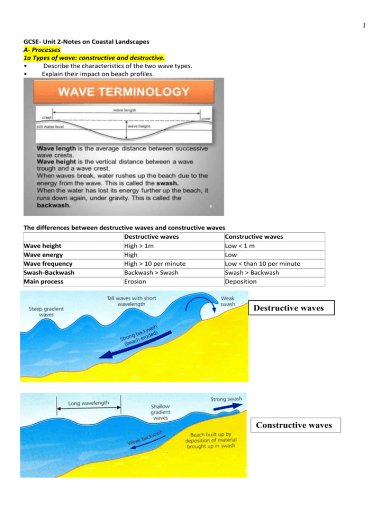
The differences between destructive waves and constructive waves
Destructive waves
Constructive waves
Wave height
High > 1m
Low < 1 m
Wave energy
High
Low
Wave frequency
High > 10 per minute
Low < than 10 per minute
Swash-Backwash
Backwash > Swash
Swash > Backwash
Main process
Erosion
Deposition
Destructive waves
Constructive waves
2
Explain the impact of waves on beach profiles.
Process
Impact on beach
profile
Constructive waves
Greater swash than backwash. Sand and shingle
moved up the beach = deposition
Sediment is being added to the beach which the
backwash cannot entirely remove, producing a
gentle build-up of beach material. This will increase
the gradient of the beach in its lower section.
(swash zone)
Destructive waves
Greater backwash than swash. Most
material is carried downward by the
backwash= erosion
Due to erosion, beach profile becomes
gentler in its lower section. (swash zone)
1b Types of weathering, erosion and mass movement on the coastline.
•
Define and explain the different types of weathering, erosion and mass movement.
Four processes of erosion: See Figure on types of erosion on blog
(i) Three ways that waves erode the coast:
Hydraulic action. Air becomes trapped in joints and cracks in the cliff face. When a wave breaks, the trapped air is
compressed which weakens the cliff and causes erosion.
Abrasion. Bits of rock and sand in waves are flung against the cliff face. Over time they grind down cliff surfaces like
sandpaper.
Solution. Weak acids contained in sea water will dissolve some types of rock such as chalk or limestone.
(ii) Waves also erode rocks and pebbles by attrition. Waves smash rocks and pebbles on the shore into each other,
and they break and become smaller and smoother.
Three processes of weathering:
Explain the process of physical weathering. (3)
Freeze thaw – diurnal changes in temperature around 0 degrees (1). Water in crack widened due to freezing (1), 9%
volume increase (1) thawing leaves crack prized open – removes water (1), process repeats (1)
3
Two processes of mass movement:
Explain the process of soil creep. (3)
4
B- Landforms of erosion and deposition
•
Describe the named landforms.
•
Explain their formation in terms of sequence and the processes involved, including the influence of vegetation
and geology.
1- Landforms of erosion: cliffs and wave-cut platforms, headlands and bays, caves, arches, stacks and stumps.
.
Headlands and bays
5
2- What is the process of longshore drift? The impact of longshore drift
•
Describe the process of longshore drift.
•
Explain the impact on the coastline in terms of landforms and related issues, e.g. deposition in estuaries.
6
Explain the impact of longshore drift on the coastline in terms of landforms and related issues, e.g. deposition in
estuaries.
The movement of materials along the coast:
- makes boulders and pebbles smaller and more rounded.
- creates landforms such as beaches, spits and bars.
- is a problem in river estuaries. Some estuaries which are
used to harbour boats have to be constantly dredged
because of longshore drift depositing material.
Dredging:
3- Landforms of deposition: How are beaches, spits and bars formed?
Describe the named landforms and explain their formation in terms of sequence and the processes involved.
Explain the formation of beaches (4)
Area of land between the low tide and storm tide marks. Made up of deposited sand and pebbles. Formed by
constructive waves. Often in bays, where waves have less energy due to gentle sloping land. Along straight stretches
of coastline where longshore drift occurs
Formation of a spit
7
Explain how a bar is formed. (4)
A bar is a long, narrow stretch of pebbles and sand (1) which grows across a bay (1) attached to the land at both
ends. (1) It forms when longshore drift occurs on a coastline. (1) When the coastline ends, the sea deposits the
material it is transporting because the change in depth affects its ability to transport the material further. (1)
If a spit develops in a bay, it may build across it, linking two headlands to form a bar. (1) This is only possible if there
is a gently sloping beach (1) and no river entering the sea, (1) because the sand will be removed faster than it can be
deposited. (1
C- Coastal Recession
1- Differential rates of cliff recession due to factors such as fetch, geology and coastal management.
•
Define cliff recession.
•
Explain the factors that cause cliff erosion – wave action, weathering and mass movement.
Coastal recession: when the coast is eroded and retreats.
Case study: Happisburg (North Norfolk coast)
Village of Happisburg (population= 850)
Factors which explain high rates of erosion in this area:
Geology: Cliff made of soft rock (clay, gravel and sand deposited by glaciers)
Lack of Coastal management ('Do nothing' policy)
No sea defences: 1958: use of revetments to reduce coastal erosion. From 1995 no repairing of coastal defencesè
high rates of erosion.
Government has refused to protect the village because it is not cost effective: the village is less valuable than the
cost of the defences to protect it.
Explain how the type of rock (geology) and structure can affect the rate of coastal erosion. (4)
Rock type - if the cliffs are made from resistant rock, (1) like granite, (1) they will erode more slowly than cliffs made
from less resistant rock, (1) such as clay.
Rock structure - the rock’s structure can also have an effect on the rate of erosion. Rocks that are well jointed (1) or
with many faults, (1) such as limestone, (1) will erode more quickly (1) as the waves exploit these lines of weakness.
(1)
8
Suggest how wave fetch can cause different rates of coastal recession. (3)
Fetch: The length of water the wind blows over. Longer distance waves have more energy (1), more power to erode
(1), increasing hydraulic action/abrasion (1).
2- The effects of coastal recession on people and the environment.
•
Describe the effects of coastal recessions on humans, e.g. insurance and loss of homes.
•
Describe the effects on the environment, e.g. loss of land.
Effects on people: Case study: Happisburg (North Norfolk coast)
Loss of homes: Since 1995: 25 properties and the village’s lifeboat launching station washed away.
Loss of value: Houses worth £80,000 when the coast was defended, are now valued at 1£.
No insurance of property against coastal erosion.
Loss of business: Over the next 100 years: 1400 caravan and chalet parks, six hotels and guest houses. Seven historic
buildings and seven golf course holes will be lost to the sea.
Effects on the environment: Case study: Durlston Bay
Loss of land: At Durlston Bay near Swanage the cliff receded 12 metres between 1968 and 1988. In 200/01 severe
storms and high energy waves led to a further retreat of another 12 metres.
Loss of natural habitats: Durlston County Park also lies on the top and is home to over 250 species of birds that nest
on the cliff. These habitats are threatened by cliff recession, which can affect the breeding of rare species such as
puffins and falcons.
D- Coastal flooding: Prediction and prevention of the effects of coastal flooding by forecasting, building design,
planning and education.
•
Briefly consider what coastal flooding is and what causes it. Factors which increase vulnerability
•
Identify how the effects of coastal flooding are reduced through planning before the event
1- Briefly consider what coastal flooding is and what causes it. Factors which increase vulnerability
Coastal flooding occurs when normally dry, low-lying land is flooded by sea water.
- Causes of coastal flooding:
Severe weather: Strong winds and storms which can increase the height of waves and tides. Storm surge: A storm
surge is an offshore rise of water associated with a low pressure weather system*, typically tropical cyclones. Storm
surges are caused by high winds pushing on the ocean's surface. The wind causes the water to pile up higher than
the ordinary sea level.
*A low-pressure area, low or depression, is a region where the atmospheric pressure is lower than that of
surrounding locations
Sea level rise: Coastal flooding associated with sea level rise will become a significant issue into the next 100 years.
- Factors which increase vulnerability
Tides, low-lying land, and property built on low-lying land.
2- Prediction and prevention of the effects of coastal flooding by forecasting, building design, planning and
education.
Forecasting
UK (HIC): The Met Office predicts (forecasts) the likelihood of a flood. The information gets to householders through
weather forecasts and news broadcasts on the TV and radio. It is also on their website.
The Environment Agency monitors sea conditions 24 hours a day, 365 days a year. Forecasts of coastal flooding are
provided on a 24-hour Flood hotline.
Bangladesh (LIC): The Meteorological Department has three radar stations that transmit weather updates.
The Bangladesh Disaster Bureau also issues cyclone alerts through the national media as soon as a cyclone is
detected by satellites.
9
Planning
UK: Before building takes place a full check must be made to ensure that the area is not prone to flooding. Planning
permission will not be granted if it is.
The Thames Flood Barrier was completed in 1982. However, new flood walls along the river and many other flood
defence techniques will be installed to protect the London area against flooding.
(See photo of the Thames Flood Barrier on blog)
Bangladesh: The Coastal Embankment project has led to the building of 12 sea-facing flood walls and 500 flood
shelters.
Building design
Bangladesh: All one-storey or two-storey buildings must have an external staircase to the roof.
Malibu (California): Houses are built on stilts to protect them from storm tides. Therefore when flooding occurs
possessions are not destroyed as the water is able to pass below the home
Houses should minimise penetration from wind, rain and storms.
Education
UK: The government gives advice to the public via its website. There is general advice on how to protect their homes
from flooding and what to do if a flood occurs.
UK: Environmental Agency page: Prepare your property for flooding.
Bangladesh is integrating education about disaster preparedness into school curricula for grades three through ten.
Schools practice safety programs and drills nationwide in March and October.
The country has already had an effective warning system for more than four decades.
In 2007 Cyclone Sidr struck Bangladesh and killed about 3,000 people. It was estimated that the cyclone warning
system helped saved 100,000 lives.
E- How the coast is managed.
1- The types of hard and soft engineering used on the coastline of the UK, and the advantages and disadvantages
of these techniques.
•
Define hard and soft engineering.
•
Describe hard and soft engineering techniques used in the UK, including groynes, sea walls, off-shore reefs,
riprap, revetments, beach replenishment, managed retreat and cliff regrading. Advantages and disadvantages of
each technique.
10
Hard engineering
Method of coastal management which involves major construction work: groynes, sea walls, off-shore reefs, riprap,
revetments. Gabions are included in textbook but not in Edexcel syllabus.
Method
Advantages
Disadvantages
Sea wall
It protects the base of the cliff
Expensive to build and to maintain.
A long concrete barrier built at the against erosion as it reflects and
Restricts access to the beach.
base of a cliff. The modern ones
absorbs wave energy.
have a recurved face.
Effective for many years.
Groynes
Prevents the movement of beach
Look ugly and do not last very long when
Wooden, rock or concrete ‘fences’ material along the coast by
they are made of wood as it rots.
built across the beach,
longshore drift.
Sand is prevented from moving along the
perpendicular to the coastline
Sand builds up on one side of the
coast, and places elsewhere may lose their
groyne and the beach builds up as
beach and the natural defence it provides.
a natural defence against erosion
and as an attraction for tourists.
Off-shore reefs
Rock or concrete barriers built on
the sea a short distance from the
coastline.
Waves break on the barrier before
reaching the coast. This reduces
erosion.
They allow the build-up of sand
along the coast and allow a wide
beach to develop as wave energy
is reduced.
Very expensive to build.
May be removed by heavy storms.
Riprap
Large boulders of resistant rock
placed in front of the cliff.
These absorb wave energy and
protect the cliff behind from
erosion.
Effective for many years.
Can make the beach inaccessible to tourists.
As they stil let some wave energy through,
they are not effective in storm conditions.
Missing from textbook:
Revetments
Slatted wooden structures built at
the base of the cliff.
These absorb and spread wave
energy through slats.
They do not interfere with
longshore drift.
Regular maintenance is needed.
Not effective in storm conditions.
Soft engineering: method of coastal management which works with natural processes at work on the coastline and to
be unobstructive (unnoticeable) visually. It does not involve major construction: beach replenishment, managed retreat
and cliff regrading.
Beach replenishment
Looks natural.
The sea keeps on eroding it away. So it has
Adding sand and pebbles on a
Provides a beach for tourists.
to be replaced constantly.
beach.
The beach absorbs wave energy
Disruption for home-owners as large noisy
and protects the land or buildings
lorries full of sand regularly replenish the
behind.
beach.
Cliff regrading
Making the cliff face longer so
that it has a gentle slope to stop it
slumping.
This method is relatively cheap.
May be covered in ecomatting to
encourage vegetation growth. (See
Figure)
Managed retreat
Allowing the sea to gradually flood
land and erode cliffs.
Natural processes are allowed to
happen.
Cheap.
See photos on blog of each method.
Not effective alone. Other methods need to
be used at the base of the cliff to stop it
being eroded.
Properties on the cliff may have to be
demolished.
Compensation has to be paid.
Upsetting for landowners who lose land.
11
2- How the coast is managed in a named location.
•
Describe how the coast is managed in a named location.
•
Consider the costs and benefits of different approaches to protecting the coast in a named location.
Case Study Swanage In Dorset on the south coast of England
In Durlston Bay, erosion mainly occurs at one particular point, where there was a major weakness in the resistant
limestone rock. There were three methods used to protect the cliffs from erosion (recession): Cliff regrading –
extending it forward, making slope longer and less steep. Reduces the risk of mass movement. Drainage – removing
excess water, so slope wasn’t as heavy or lubricated after rain. Reduces the risk of mass movement and freeze-thaw
weathering. Rip rap placement – Large boulders at the base of the cliff to resist wave attack and dissipate wave
21energy.
Swanage Bay
This is a popular recreational area for beach users, diving, fishing and sailing. Erosion occurred along a considerable
length of cliff.
Sea wall- Built in the 1920s and provided a promenade as well as a barrier to wave attack.
Groynes- The most cost effective method was found to be the replacement of the 1930s groynes and replenishment
of the beach sediment. A series of mainly timber groynes were installed in the 1930s, and eighteen of them have
been replaced in 2005 with new ones. These reduced longshore drift and help make sure that a beach remained in
place to absorb the energy of breaking waves.
Beach replenishment
In November of 2005, 90,000 m3 of sand was deposited on the beach. The beach will need to be recharged with
around 40,000m3 of sand every 20 years. This works with the groynes to ensure a good size beach. The works were
finally completed in June 2006at an estimated cost of £2.2 million.
Cliff regarding: A series of steps were made in the cliff to reduce slope angles.
Coastal management issues:
1- The potential impact of any coastal defence works on Swanage tourism and the aesthetic and landscape quality of
the coastline.
2- The cost of protecting the coast
3- The efficiency of the methods used: In January 1st, 201 3, Dorset Coastguard have restricted access to Swanage
beach and the South West Coastal Paths, after heavy rains over the holiday period caused further mudslides and cliff
subsidence in Swanage.


