LXSS_Gr12Geography_Climatology_2014
advertisement
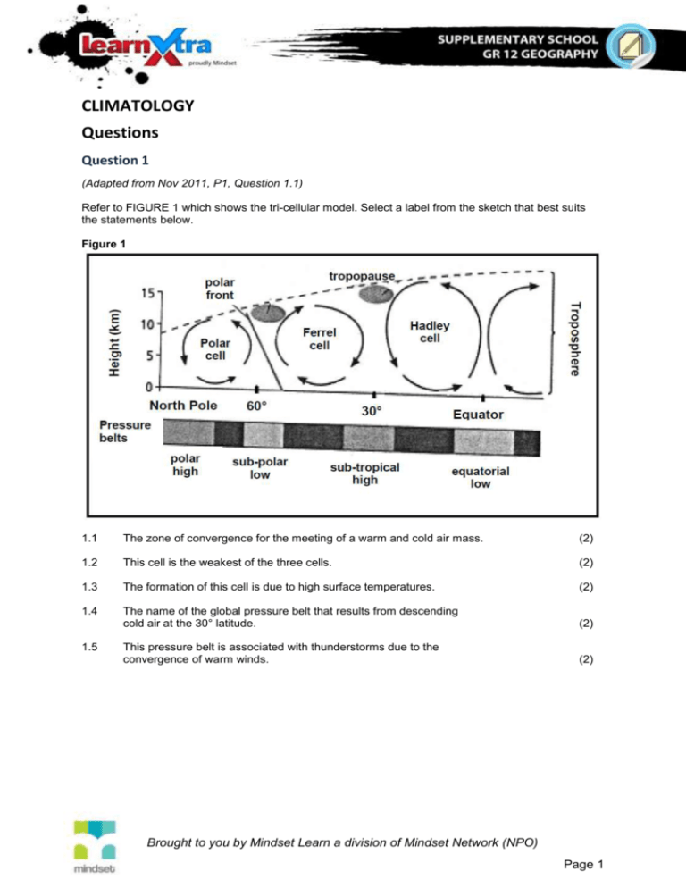
CLIMATOLOGY Questions Question 1 (Adapted from Nov 2011, P1, Question 1.1) Refer to FIGURE 1 which shows the tri-cellular model. Select a label from the sketch that best suits the statements below. Figure 1 1.1 The zone of convergence for the meeting of a warm and cold air mass. (2) 1.2 This cell is the weakest of the three cells. (2) 1.3 The formation of this cell is due to high surface temperatures. (2) 1.4 The name of the global pressure belt that results from descending cold air at the 30° latitude. (2) This pressure belt is associated with thunderstorms due to the convergence of warm winds. (2) 1.5 Brought to you by Mindset Learn a division of Mindset Network (NPO) Page 1 Question 2 (Adapted from Nov 2011, P1, Question 2.1) Refer to FIGURE 2 which shows air movement in a valley. Choose the correct word(s) from those given in brackets. Figure 2: 2.1 The valley wind labelled A is a/an (katabatic/anabatic) wind. (2) 2.2 This wind occurs during the (day/night) in valleys. (2) 2.3 It is also referred to as a/an (upslope/downslope) wind. (2) 2.4 The zone labelled B is the (thermal belt/frost pocket). (2) 2.5 The form of precipitation experienced at C is (frost/snow). (2) Brought to you by Mindset Learn a division of Mindset Network (NPO) Page 2 Question 3 (Adapted from Nov 2011, P1, Question 1.3) Refer to FIGURE 3 which captures the path and effect of tropical cyclone Yasi. Figure 3 CYCLONE YASI STRIKES AUSTRALIA Category-five cyclone tears roofs, pubs and houses, topples trees and sends power cables crashing on to roads. The residents of Australia are assessing the damage after cyclone Yasi, the largest tropical storm to strike Australia since Europeans first settled there, created winds of 280 km/h and waves more than 9 m high. Thousands of the 400 000 people living in the path of the 500 km wide cyclone spent a sleepless night in hot and crowded emergency evacuation centres set up in primary schools and shopping centres deemed strong enough to withstand the cyclone and avoid storm surges up to 8 m high. On Mission Beach power cables crashed on to the roads and mature trees and palms were toppled by surging winds but local residents also reported an unusual half-hour in the eye of the storm. 'It's the strangest thing to go outside and see the stars and there is no wind for half an hour.' 3.1 On what date did cyclone Yasi strike the coast of Australia? (1 x 2) (2) 3.2 Name TWO conditions that would have favoured the development of Yasi. (2 x 2) (4) 3.3 What evidence from FIGURE 1.3 suggests that cyclones are common in Australia? (1 x 2) (2) Explain what you understand by a category-five cyclone. (2 x 2) (4) 3.4 Brought to you by Mindset Learn a division of Mindset Network (NPO) Page 3 3.5 Refer to the statement 'local residents reported an unusual half-hour in the eye of the storm'. (a) Why do they describe the weather conditions in the eye as unusual? (b) Explain what causes the unusual conditions in the eye. (2 x 2) (4) (1 x 2) (2) 3.6 What is the local name for tropical cyclones in Australia? (1 x 2) (2) 3.7 Why do you think Australia would have an efficient emergency programme ready to handle natural hazards? (1 x 2) (2) Question 4 (Adapted from Nov 2011, P1, Question 2.3) Study the synoptic weather map in FIGURE 4 and answer the questions below. Figure 4: 4.1 Name the anticyclone labelled B. (1 x 2) (2) 4.2 Give a reason why pressure systems B and C are known as anticyclones. (1 x 2) (2) 4.3 A group of students must go on a field trip to Durban on the day presented by this synoptic weather map. What temperature will they experience on the day of their field trip? (1 x 2) (2) 4.4 Briefly describe how the front labelled D is formed. (2 x 2) (4) 4.5 Name the weather system labelled A. (1 x 2) (2) 4.6 In which general direction does the weather system A move? (1 x 2) (2) 4.7 Is weather system A likely to influence the weather conditions of Cape Town within the next 24 hours? Explain your answer. (2 x 2) (4) Brought to you by Mindset Learn a division of Mindset Network (NPO) Page 4 4.8 Of what importance are weather systems such as A to farming in the Western Cape area in winter? (1 x 2) (2) Question 5 (Adapted from Nov 2011, P1, Question 1.4) FIGURE 5 is a cartoon that highlights issues of climate change and its effects. Figure 5: 5.1 What do you understand by the term climate change? (1 x 2) (2) 5.2 Explain how it is possible for flooding to be linked to petrol use. (2 x 2) (4) 5.3 Sustainable measures need to be taken to address the challenges associated with flooding. Write a single paragraph (approximately 12 lines) discussing possible solutions that local municipalities can employ to reduce the effects of flooding. (6 x 2) (12) Brought to you by Mindset Learn a division of Mindset Network (NPO) Page 5

