INTEGRATED SAFEGUARDS DATA SHEET ADDITIONAL
advertisement
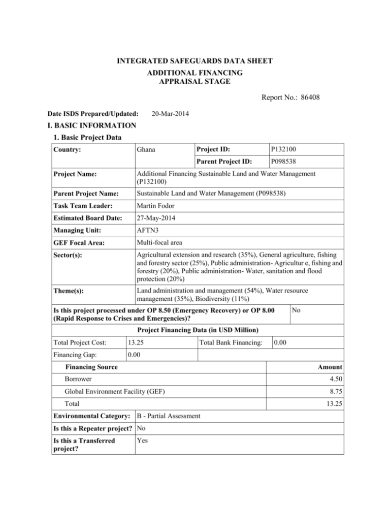
INTEGRATED SAFEGUARDS DATA SHEET ADDITIONAL FINANCING APPRAISAL STAGE . Report No.: 86408 . Date ISDS Prepared/Updated: 20-Mar-2014 I. BASIC INFORMATION 1. Basic Project Data Country: Ghana Project ID: P132100 Parent Project ID: P098538 Project Name: Additional Financing Sustainable Land and Water Management (P132100) Parent Project Name: Sustainable Land and Water Management (P098538) Task Team Leader: Martin Fodor Estimated Board Date: 27-May-2014 Managing Unit: AFTN3 GEF Focal Area: Multi-focal area Sector(s): Agricultural extension and research (35%), General agriculture, fishing and forestry sector (25%), Public administration- Agricultur e, fishing and forestry (20%), Public administration- Water, sanitation and flood protection (20%) Theme(s): Land administration and management (54%), Water resource management (35%), Biodiversity (11%) Is this project processed under OP 8.50 (Emergency Recovery) or OP 8.00 (Rapid Response to Crises and Emergencies)? No Project Financing Data (in USD Million) Total Project Cost: 13.25 Financing Gap: 0.00 Total Bank Financing: Financing Source Amount Borrower 4.50 Global Environment Facility (GEF) 8.75 Total 13.25 Environmental Category: B - Partial Assessment Is this a Repeater project? No Is this a Transferred project? . 0.00 Yes . 2. Project Development Objective(s) A. Original Project Development Objectives - Parent Project Development Objective is: To (a) demonstrate improved sustainable land and water management practices aimed at reducing land degradation and enhancing maintenance of biodiversity in selected micro-watersheds, and (b) strengthen spatial planning for identification of linked watershed investments in the Northern Savannah region of Ghana. Key Indicators for PDO: - Area of land in selected micro-watersheds under new sustainable land and watershed management (SLWM) technologies (ha); - Management effectiveness according to METT score in Gbele Resource Reserve and Wuru Kayero and Wahabu Wiasi corridor sites (score, disaggregated); - Pre-feasibility studies conducted for new large-scale multipurpose water storage investments (number) . B. Current Project Development Objectives - Parent Revised Project Development Objective is: to expand the area under sustainable land and water management practices in selected watersheds Key Indicators for PDO: - Land area where sustainable land and water management practices have been adopted as a results of the project (ha); - Land users adopting sustainable land management practices as a result of the project (number) - Management Effectiveness Tracking Tool score in Gbele Resource Reserve and Wuru Kayero, Wahabu Wiasi, Sumboru Bechausa and Gbele-Mole corridor sites (score 0-100); - Direct project beneficiaries (number), of which female (percentage). . C. Proposed Project Development Objectives - Additional Financing (AF) Revised Project Development Objective is: to expand the area under sustainable land and water management practices in selected watersheds Key Indicators for PDO: - Land area where sustainable land and water management practices have been adopted as a results of the project (ha); - Land users adopting sustainable land management practices as a result of the project (number) - Management Effectiveness Tracking Tool score in Gbele Resource Reserve and Wuru Kayero, Wahabu Wiasi, Sumboru Bechausa and Gbele-Mole corridor sites (score 0-100); - Increase in the amount of biomass in the intervention area (ton/ha); - Direct project beneficiaries (number), of which female (percentage). . . 3. Project Description The Sustainable Land and Water Management Project (SLWMP) is designed around three components: (1) Capacity building for integrated spatial planning, (2) Water and Land Management, and (3) Project management and coordination. The project supports a comprehensive landscape approach to sustainable land and watershed management at the community level with planning activities at the regional and district levels. Additional financing to the project will upscale and expand activities within the same component structure. Component 1 – Capacity Building for Integrated Spatial Planning - is currently undertaking activities that will lead to improved spatial planning to address land and water management needs. This is achieved through the implementation of the following: preparing an integrated spatial development framework; undertaking two pre-feasibility studies for large scale multi-purpose water storage investments; and supporting GIS capacity at the Savannah Accelerated Development Authority (SADA) headquarters in Tamale. The outputs of Component 1 will guide future water investments in Northern Ghana. This Component will receive no additional funding under the AF grant. Component 2 – Land and Water Management - will continue supporting activities related to the implementation of SLWM technologies such as Agro-forestry, rangeland management, conservation agriculture, small- scale water storage facilities, among others, which would lead to enhancement of the productivity of the soils, enhancement of ecosystem services and increase in agricultural productivity that would enhance the livelihood of the beneficiaries and reduce their poverty levels. The Project will support SLWM implementation in two new districts (Daffiama-Bussie-Issa and Mamprugu Moaduri), in addition to the current districts (Builsa South, Talensi, Bawku West, Kassena-Nanakna West, Wa East, Sissala East, Sissala West, and West Mamprusi). With introduction of the Additional Financing, the Component will have more specific focus on rangeland management activities, as one of the supported SLWM technologies. The activities on management of riparian and other biological corridors will expand in coverage and will now include two additional corridor sites (Sumboru Bechausa and Gbele-Mole), in addition to the two sites already supported (Wuru Kayero and Wahabu Wiasi). The Component will also include new SFM activities aimed at reducing pressures on gazetted forest estate and creating a contiguous management zone of the forests between Gbele Resource Reserve and Mole National Park. Component 3 – Project Management and Coordination - supports project coordination, monitoring, and supervision of the various stakeholders involved in the project implementation, including under Additional Financing. 4. Project location and salient physical characteristics relevant to the safeguard analysis (if known) The project activities are geographically limited to Kulpawn – Sissili – Red Volta watersheds of Northern Ghana. In particular, SWLM activities supported by the Project take place in the following districts of Northern Ghana: current districts - Builsa South, Talensi, Bawku West, Kassena-Nanakna West, Wa East, Sissala East, Sissala West, and West Mamprusi; and new districts under AF Daffiama-Bussie-Issa and Mamprugu Moaduri). The biodiversity and sustainable forest management activities will take place within the Western Biodiversity Corridor (including Gbele Resource Reserve; four Community Resource Management Areas of Wuru Kayero, Wahabu Wiasi, Sumboru Bechausa, and Gbele Mole; and eight Forest Reserves – Ambalara, Kulpawn Tributaries, Pudo Hills, Mawbia, Chiana Hills, Sissili North, Sissili Central, and Bepena Forest Reserves. The project location is within the northern savanna region of Ghana, and more specifically within the sub-watersheds of the main tributaries of the White Volta that flow into northern Ghana from Burkina Faso, and the wildlife corridors within them, particularly the corridor joining Gbele Resource Reserve with Mole National Park, and then linking these with Nazinga Reserve in Burkina Faso along the Sissili River. Most of the project area falls within the Guinea Savannah zone, although activities may extend into a small area of Sudan Savannah in the extreme northeast corner of the country. The Guinea and Sudan Savannah zones are both characterized by a unimodal rainfall regime lasting from April to October, although mean annual rainfall is higher in the Guinea Savannah zone (1000-1200 mm), than in the Sudan Savannah (900-1000 mm). The period between November and March is dry and characterized by the desiccating harmattan winds, rendering the zone prone to bush fires. The mean annual maximum temperature ranges from 33°C to 35°C with a minimum of about 22°C. The length of the growing period is 180-200 days for the Guinea savannah, and 150-160 days for the Sudan savannah. Most of the area consists of a gently rolling plain with average heights between 180 and 300 masl, overlying granitic and gneissic rocks. The soils of these areas, including ground-water laterites and savannah ochrosols, are moderately fertile but erosion is a serious problem. Due to challenging agricultural and climate conditions and limited transport access, poverty is concentrated in the north. Most inhabitants are food-crop producers, and the small scale family holding is the basic unit of production. Most individuals have user rights to land which is owned by traditional land owners (Tindanas). Livestock are mostly grazed on communal lands without restriction within a community. Cattle ownership is of importance to socio-economic status, and as a result most owners put an emphasis on herd size rather than quality. There is potential for conflict between settled agriculturists and itinerant pastoralists, mostly Fulani coming from outside of Ghana, although some pastoralists are employed by locals to tend their cattle. Suitable farming land is a major constraint, and increasing population pressure is leading to intensified and unsustainable cropping, as well as other activities such as game hunting and charcoal burning. Intensification without modification of traditional practices is leading to land degradation and soil erosion through depletion of nutrients and loss of vegetation cover (partly due to burning practices). Natural vegetation is also being lost through bushfires, illegal logging and encroachment of forest reserves. Reduced infiltration and siltation of rivers lessen water availability, which in turn increases sensitivity to erosion. All of the north is at high to severe risk of land degradation, and the associated social vulnerability may well be most severe there because: (i) the north is also prone to severe flooding which is not only exacerbated by land degradation, but also reduces the area of reliable agricultural land; (ii) extreme poverty restricts access to alternative livelihoods or more resilient production systems; and (iii) the northern savannah is likely to be one of the regions most impacted by climate change. The Western Biodiversity Corridor Corridor extends over 143 km of natural vegetation between Nazinga Game Ranch in the north to Mole National Park in the south, covering portions of the Upper East and Upper West Regions, encompassing the sub-watersheds of the main tributaries of the Sissili and Kulpawn Rivers that flow into northern Ghana from Burkina Faso. The corridor has a perimeter of approximately 865 km and a surface area of about 4,786 km2. The Gbele Resource Reserve is one of the eighteen Wildlife Reserves (Protected Areas) in Ghana. It is the only gazetted Protected Area (PA) in the Upper West Region and a representative sample of the Guinea Savannah Woodland Vegetation. The Reserve was established under the Wildlife Reserves (Amendment) Regulation of 1975 (L.I. 1022). Geographically, the reserve is located between latitude 10° 22' and 10° 44' N and longitude 2° 03' and 2° 12' W and covers a total area of about 565 km2 with a perimeter of about 125 km. It is about the third largest protected area in the country after Mole and Digya National Parks. The Gbele Resource Reserve provides a fairly good example of unmodified Guinea Savannah habitat, with a large number/variety of woody and other species and a grass layer 3 m tall during the rainy season. The fruits of sheanut and dawadawa trees, many species of grasses, used for thatch, brooms and mats, medicinal plants and other edible plant and fruits are important to local people. Gbele Resource Reserve also has a rich bird fauna, and a study in 2005 showed that there are about 194 bird species in the reserve. The reserve contains a number of large ungulates and primates, but densities are lower than the nearby Mole National Park, and many of the most charismatic species, such as large carnivores, elephant, and buffalo are absent or extremely rare. The wildlife corridors and other remaining semi-natural habitat areas have a similar composition, but represent various levels of degradation, particularly from hunting, cutting of trees for wood fuel, grazing, and over-burning. The target forest reserves - Ambalara, Kulpawn Tributaries, Pudo Hills, Mawbia, Chiana Hills, Sissili North, Sissili Central, and Bepena Forest Reserves - are remote savanna woodlands with watershed protection and production functions under low intensity forest management regime. Ambalara FR and Kulpawn Tributaries Forest Reserves, together with Gbele Resource Reserve, form a forested structure of the landscape in the Kulpawn and Sissili Rivers Watersheds. . 5. Environmental and Social Safeguards Specialists on the Team Franklin Kuma Kwasi Gavu ( AFTN3 ) Felix Nii Tettey Oku ( AFTN3 ) . 6. Safeguard Policies Triggered? Explanation (Optional) Environmental Assessment OP/BP 4.01 Yes While most SLM activities are not expected to generate any significant adverse environmental and social impacts, some activities may result in site-specific and small-scale consequences if no appropriate mitigation measures are incorporated in sub-project design. An Environmental Analysis and Management Plan (EAMP) has been developed and is in place to guide mitigation of potential identified risks. Natural Habitats OP/BP 4.04 Yes The project will operate in and around natural habitats. The project is not expected to have any adverse effects on these natural habitats. Forests OP/BP 4.36 Yes The project will operate in and around forests inside and outside protected areas. The project is not expected to have any adverse effects on these forests. All activities within the forest reserves are guided by the Forest Management Plans. Pest Management OP 4.09 Yes Introduction of improved farming systems could encourage increased use of pesticides as farmers strive to increase agricultural production, even though the Project will not finance these. A simple Pest Management Plan is incorporated into the EAMP to explain how integrated pest management techniques will be included within those SLM technologies that may present some risk in this regard. Physical Cultural Resources OP/BP 4.11 No This policy is not triggered and the project will not finance any activities that affect Physical Cultural Resources Indigenous Peoples OP/BP 4.10 No The Project does not affect Indigenous Peoples Involuntary Resettlement OP/BP 4.12 Yes No land acquisition or involuntary resettlement is envisaged and no new government protected areas are being established. However, watershed management activities in CREMAs will be community driven, and OP 4.12 has been triggered and a Resettlement Policy Framework was prepared. Safety of Dams OP/BP 4.37 No The Project does not support construction or maintenance of dams Projects on International Waterways OP/BP No 7.50 The Project does not support activities on international waters Projects in Disputed Areas OP/BP 7.60 The Project does not support activities in disputed areas No . II. Key Safeguard Policy Issues and Their Management A. Summary of Key Safeguard Issues 1. Describe any safeguard issues and impacts associated with the proposed project. Identify and describe any potential large scale, significant and/or irreversible impacts: Although five (5) safeguards policies have been triggered, the potential negative social and environmental impacts of activities are expected to be minimal and localized. In general, environmental and social impacts are expected to be highly positive as the overall aim is to improve land, water and natural habitat management through technologies which benefit participating communities and individuals. In order to be included in the menu of options for application during the project, an SLM technology first needs to be judged to have a clear (and potentially quantifiable) environmental benefit, which will be denoted by its score on an environmental services index. OP/BP 4.01 (Environmental Assessment). An Environmental Analysis and Management Plan (EAMP) has been developed and is in place to guide mitigation of potential identified risks. While most SLM activities are not expected to generate any significant adverse environmental and social impacts, some activities may result in site-specific and small-scale consequences if no appropriate mitigation measures are incorporated in sub-project design. E.g.: (i) Care must be taken to avoid introducing species through SLM techniques that could become invasive or adversely impact soil water balance. Species will be carefully selected for on farm integration based on experience from other similar environments. (ii) Introduction of improved farming systems could encourage increased use of inorganic fertilizers. SLM technologies will therefore incorporate integrated fertility management. (iii) SLM technologies linked to dry season irrigation have the potential to increase water extraction, thus affecting downstream flows. The project will only support interventions that credibly improve overall hydrological services, improving efficiency of irrigations systems and establishing local regulations and enforcement by water users associations. (iv) Fire control can damage natural systems and be counterproductive if applied overly rigidly. The project will therefore support fire reduction and management to more closely approximate natural fire ecologies, rather than outright fire suppression. The EAMP describes the processes to ensure all these considerations are adequately incorporated in project activities, and also defines a negative list of activities that cannot be supported under the project to avoid unintended environmental impact. It was disclosed publicly in Ghana and the Bank’s Infoshop (on 30 July, 2010); it was also re-disclosed during preparation of the Additional Financing, on March 17, 2014. OP/BP 4.04 (Natural Habitats) and OP/BP 4.36 (Forests). The project will operate in and around natural habitats and in forests inside and outside protected areas. The project is not expected to have any adverse effects on forests and other natural habitats, on the contrary the aim is to improve community-based natural habitat management, including through fire management, improving management of Gbele Resource Reserve and target forest reserves as well as improving the productive quality of agricultural land, which should reduce pressures for unsustainable exploitation. The Project will support improved forest management through assessment and diagnostic studies and updated of the Forest Management Plans (FMPs) for the eight target forest reserves. Existing FMPs for the forest reserves are publicly disclosedy at the District and Regional Offices of the Foresty Commission in Upper West and Upper East Regions; they were disclosed in the World Bank Infoshop on March 20, 2014. OP/BP 4.09 (Pest Management). Introduction of improved farming systems could encourage increased use of pesticides as farmers strive to increase agricultural production, even though the Project will not finance these. A simple Pest Management Plan i s, therefore, incorporated in to the EAMP to explain how integrated pest management techniques will be included within those SLM technologies that may present some risk in this regard. OP/BP 4.12 (Involuntary Resettlement). No land acquisition or involuntary resettlement is envisaged and no new government protected areas are being established. However, watershed management activities in CREMAs will be community driven, and OP 4.12 has been triggered and a Resettlement Policy Framework was prepared. With the variety of SLM options that will be available, there are potentials for access to resources to be restricted, possibly resulting in negative impact on livelihoods as the result of community-level choices. Restrictions of access to natural resources are possible through the establishment of CREMA management systems. The process framework describes the community based participatory process by which sub-projects will be prepared and implemented, what mitigation measures will apply and the grievance redress process. In some cases, communities and tindanas (customary landowners) may determine to set aside as a protective riverine buffer, or community woodlots, requiring tenant farmers to vacate. In such cases, community action will make available other suitable land available for lease to the affected farmers. A broad social assessment was carried out during preparation, and a more detailed social baseline will be established in project areas during implementation. The RPF has been prepared and disclosed publicly in Ghana and the Bank’s Infoshop on July 31, 2010; it was also re-disclosed during preparation of the Additional Financing, on March 17, 2014. 2. Describe any potential indirect and/or long term impacts due to anticipated future activities in the project area: No long-term adverse impacts were identified in the prepared safeguards instruments, the EAMP, the RPF, and the FMPs. 3. Describe any project alternatives (if relevant) considered to help avoid or minimize adverse impacts. Not relevant. 4. Describe measures taken by the borrower to address safeguard policy issues. Provide an assessment of borrower capacity to plan and implement the measures described. Ghana has developed institutional capacity for relevant safeguards policies in various sectoral ministries with the satisfactory implementation of safeguards instruments under previous Bank operations, including related projects such as the Community-Based Rural Development Project and the Northern Savanna Biodiversity Conservation project, implemented through the same front-line agencies as involved in this project. The Ministry of Environment, Science, Technology, and Innovation (the Project’s Implementing Agency) through the Environment Protection Agency (EPA), oversees national environmental safeguards policies and has acquired experience of implementing first phase of SLWMP since 2011. EPA is one of the key project agencies implementing parts of the project, and involved through planning, implementation and monitoring and quality assurance of SLM activities, in addition to overseeing environmental and social due diligence. The EPA has cleared the EAMP and RPF, on behalf of the Government of Ghana. MESTI, with support from the EPA, will be responsible for ensuring appropriate inclusion of safeguards procedures in project manuals, reviewing investment plans for compliance and monitoring of safeguards performance overall. Districts and the Forestry Commission offices implementing activities on the ground will be responsible for implementation of safeguards measures reflected in the safeguards documents and various sections of the project implementation manual (PIM). The EPA & SADA will ensure that all project-supported prefeasibility or other planning studies of new large-scale water storage or flood protection investments will include due attention to the potential project specific and cumulative environmental impacts. 5. Identify the key stakeholders and describe the mechanisms for consultation and disclosure on safeguard policies, with an emphasis on potentially affected people. During the preparation of the original Project, consultations meetings were organized with District representatives, NGOs and local communities during preparation of the parent project. During the consultations all applicable Project procedures were presented and discussed extensively, including the applicable safeguard policies and review procedures. Community activities, including those proposed under this AF, will be developed and approved through inclusive consultative processes for both micro-watershed and CREMA planning. The project will not fund any investment that is not acceptable to the majority of villagers involved, or SLWM agreements not acceptable to all land owners and farmers directly affected. The EAMP and RPF, prepared with public consultation, were publicly disclosed in July 2010 through the Bank InfoShop. They were also re-disclosed during preparation of the Additional Financing in March 2010. The reports are also publiclly available from MESTI/EPA in Accra. . B. Disclosure Requirements Environmental Assessment/Audit/Management Plan/Other Date of receipt by the Bank 27-Apr-2010 Date of submission to InfoShop 30-Jul-2010 For category A projects, date of distributing the Executive Summary of the EA to the Executive Directors "In country" Disclosure Resettlement Action Plan/Framework/Policy Process Date of receipt by the Bank 27-Apr-2010 Date of submission to InfoShop 31-Jul-2010 "In country" Disclosure Pest Management Plan Was the document disclosed prior to appraisal? Yes Date of receipt by the Bank 27-Apr-2010 Date of submission to InfoShop 30-Jul-2010 "In country" Disclosure If the project triggers the Pest Management and/or Physical Cultural Resources policies, the respective issues are to be addressed and disclosed as part of the Environmental Assessment/Audit/or EMP. If in-country disclosure of any of the above documents is not expected, please explain why: . C. Compliance Monitoring Indicators at the Corporate Level OP/BP/GP 4.01 - Environment Assessment Does the project require a stand-alone EA (including EMP) report? Yes [ X ] No [ ] NA [ ] Yes [ X ] No [ ] NA [ ] Are the cost and the accountabilities for the EMP incorporated in the Yes [ X ] credit/loan? No [ ] NA [ ] ] If yes, then did the Regional Environment Unit or Sector Manager (SM) review and approve the EA report? OP/BP 4.04 - Natural Habitats Would the project result in any significant conversion or degradation Yes [ of critical natural habitats? ] No [ X ] NA [ If the project would result in significant conversion or degradation of Yes [ other (non-critical) natural habitats, does the project include mitigation measures acceptable to the Bank? ] No [ ] NA [ X ] Does the EA adequately address the pest management issues? Yes [ X ] No [ ] NA [ ] Is a separate PMP required? Yes [ ] No [ X ] NA [ ] If yes, has the PMP been reviewed and approved by a safeguards specialist or SM? Are PMP requirements included in project design?If yes, does the project team include a Pest Management Yes [ ] No [ NA [ X ] OP 4.09 - Pest Management ] Specialist? OP/BP 4.12 - Involuntary Resettlement Has a resettlement plan/abbreviated plan/policy framework/process Yes [ X ] framework (as appropriate) been prepared? No [ ] NA [ ] Yes [ X ] No [ ] NA [ ] Has the sector-wide analysis of policy and institutional issues and constraints been carried out? Yes [ X ] No [ ] NA [ ] Does the project design include satisfactory measures to overcome these constraints? Yes [ ] No [ ] NA [ X ] Does the project finance commercial harvesting, and if so, does it include provisions for certification system? Yes [ ] No [ X ] NA [ ] Have relevant safeguard policies documents been sent to the World Yes [ X ] Bank's Infoshop? No [ ] NA [ ] Have relevant documents been disclosed in-country in a public place Yes [ X ] in a form and language that are understandable and accessible to project-affected groups and local NGOs? No [ ] NA [ ] Yes [ X ] No [ ] NA [ ] Have costs related to safeguard policy measures been included in the Yes [ X ] project cost? No [ ] NA [ ] Does the Monitoring and Evaluation system of the project include the monitoring of safeguard impacts and measures related to safeguard policies? Yes [ X ] No [ ] NA [ ] Have satisfactory implementation arrangements been agreed with the borrower and the same been adequately reflected in the project legal documents? Yes [ X ] No [ ] NA [ ] If yes, then did the Regional unit responsible for safeguards or Sector Manager review the plan? OP/BP 4.36 - Forests The World Bank Policy on Disclosure of Information All Safeguard Policies Have satisfactory calendar, budget and clear institutional responsibilities been prepared for the implementation of measures related to safeguard policies? . . III. APPROVALS . Task Team Leader: Name: Martin Fodor Approved By: Acting Sector Manager: Name: Sanjay Srivastava Date: March 28, 2014
