Year 9 Earthquakes – Notes and Revision Questions Name
Year 9 Earthquakes – Notes and Revision Questions Name: _______________________________
1.
Structures of the Earth:
a.
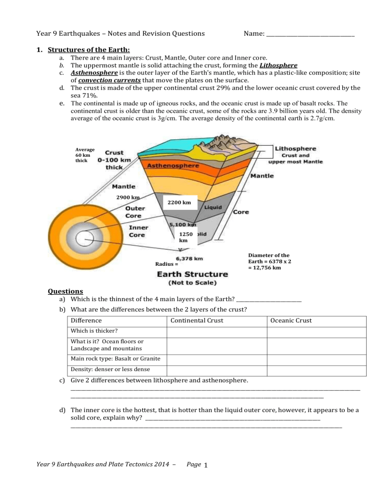
There are 4 main layers: Crust, Mantle, Outer core and Inner core. b.
The uppermost mantle is solid attaching the crust, forming the Lithosphere c.
Asthenosphere is the outer layer of the Earth's mantle, which has a plastic-like composition; site of convection currents that move the plates on the surface. d.
The crust is made of the upper continental crust 29% and the lower oceanic crust covered by the sea 71%.
e.
The continental is made up of igneous rocks, and the oceanic crust is made up of basalt rocks. The continental crust is older than the oceanic crust, some of the rocks are 3.9 billion years old. The density average of the oceanic crust is 3g/cm. The average density of the continental earth is 2.7g/cm.
Average
60 km thick
2900 km
2200 km
1250 km
Radius =
Diameter of the
Earth = 6378 x 2
= 12,756 km
Questions
a) Which is the thinnest of the 4 main layers of the Earth? _________________________ b) What are the differences between the 2 layers of the crust?
Difference
Which is thicker?
What is it? Ocean floors or
Landscape and mountains
Main rock type: Basalt or Granite
Density: denser or less dense
Continental Crust Oceanic Crust c) Give 2 differences between lithosphere and asthenosphere.
_______________________________________________________________________________________________________________
_________________________________________________________________________________________________ d) The inner core is the hottest, that is hotter than the liquid outer core, however, it appears to be a solid core, explain why? ___________________________________________________________________
________________________________________________________________________________________________________
Year 9 Earthquakes and Plate Tectonics 2014 – Page
1
2.
Tectonic Plates:
a) The lithosphere is not a continuous layer of rocks, rather it consists of at least 10 large pieces called tectonic plates. b) There are 50 smaller tectonic plates too. c) Each plate consists of the oceanic crust, continental crust and the outermost layer of solid mantle. d) Over long periods of time, the plates also change in size as their margins are added to, crushed together, or pushed back into the
Earth's mantle. These plates are from 80 to 400 km thick. e) Underneath the Lithosphere, the mantle is semi-liquid, with magma moving around by means of convection current. f) The Plate Tectonics Theory states that the lithosphere is divided into a number of crustal plates, each of which moves on the plastic asthenosphere more or less independently to collide with, slide under, or move past adjacent plates.
Questions:
a) How many major tectonic plates are shown in the above diagram? _________ b) Which is the largest tectonic plate? ________________________ c) Which plate boundary has a name known as “Ring of Fire”? Why?
____________________________________________________________________________________________
____________________________________________________________________________________________ d) Name 6 countries or places where they are at the tectonic boundaries.
____________________________________________________________________________________________
____________________________________________________________________________________________
____________________________________________________________________________________________
Year 9 Earthquakes and Plate Tectonics 2014 – Page
2
3.
Three main types of plate boundaries: a) Divergent boundary:
When two plates move away from each other.
When they move away from each other, it creates magma from the mantle.
It causes cracks into the oceanic crust.
The divergent plate boundaries are mostly on the ocean floors, eg. The Mid-Atlantic Ridge
b) Convergent Plate Boundary:
they are locations where lithospheric plates are moving towards one another.
When continental and oceanic plates collide the thinner and more dense
“Denser” oceanic plate is overridden by the thicker and less dense continental plate.
The oceanic plate is forced down into the mantle in a process known as
"subduction".
The end of oceanic plates actually melts and form magma.
The plate collisions that occur in these areas can produce earthquakes, volcanic activity and formation of mountain ranges.
Around 75% of the world's seismic energy is released at the edge of the Pacific, where the thinner Pacific plate is forced beneath thicker continental crust along 'subduction zones'.
c) Transform boundary
a plate that slides and past each other horizontally.
Eg. San Andreas fault in California.
Questions:
a) Label the diagrams with the correct types of boundary.
“Less
Dense” b) Which type of boundary forms high mountains?
_________________________________________ c) What is the meaning of Subduction?
______________________________________________________
______________________________________________________
___________________________________________________________ d) In the convergent boundary between an oceanic and a continental plate, give a reason why the oceanic plate moves down rather than the continental plate?
___________________________________________________________________________________________________
___________________________________________________________________________________________________
e)
Plate boundaries where two plates are moving apart from one another, and new plate material is being formed as molten rock rises to fill the gap between them, are called
________________________ boundary.
Year 9 Earthquakes and Plate Tectonics 2014 – Page
3
f) Label the structures: Give a title for this image.
continental crust, oceanic crust, ocean, magma, subduction, volcano, earthquake,
Lithosphere, asthenosphere
4.
The movement of tectonic plates
a.
The lithosphere in form of over 10 large pieces of tectonic plates, actually 'floats' on the asthenosphere, like ice on water. b.
Nuclear reaction inside the core generates a lot of heat. Because the earth is very hot inside, a current of heat flows from the core to the crust. c.
Hotter magma near the core is less dense and rises up and the colder magma near the crust
(denser) sinks down, this is the convection current of the molten magma. d.
When the magma cools down more, the convection current descends again and goes to the inner earth. There the temperature increases and the current rises again. This goes on and on. e.
When the magma comes at a weaker part of the crust, for example at a volcano, magma comes above the earth's surface. f.
The convection current along the bottom of the crust causes the moving of the tectonic plates. This is called plate tectonics. g.
The movement of these plates goes very slowly. The bumping of two tectonic plates causes an earthquake.
Questions:
a.
Why does the inside of the Earth get very hot? ______________________________________________ b.
Briefly describe the convection current that leads to the tectonic plates to move.
___________________________________________________________________________________________________
___________________________________________________________________________________________________ c.
What will be formed as a result of all different movement of these tectonic plates?
___________________________________________________________________________________________________
Year 9 Earthquakes and Plate Tectonics 2014 – Page
4
5.
Faults and Folds:
a.
A fault = A fracture in the Earth's crust along which the rocks on one side are displaced relative to those on the other. b.
A fold = A bend in layers of rock. c.
These are the results of the crust’s movement. d.
Many Landforms are/were formed as results of folds and faults.
6.
Differences between faults and tectonic plates:
A fault is simply a plane along which two masses of rock move relative to one another. A plate boundary is a fault in which the opposite sides are different plates. All plate boundaries involve faults, but not all faults are at plate boundaries (for example, the New Madrid fault zone in the middle of the North
American plate).
7.
What causes an Earthquake?
a.
An earthquake is caused by a sudden slip on a fault. b.
The tectonic plates are always slowly moving, but they get stuck at their edges due to friction. c.
When the stress on the edge overcomes the friction, there is an earthquake that releases energy in waves that travel through the earth's crust and cause the shaking that we feel. d.
Earthquake = A sudden ground motion or vibration produced by a rapid release of stored-up energy. e.
Earthquake Focus = where the earthquake originated from, usually underground on the fault zone. The ground ruptures at the focus, then seismic waves radiate outward in all directions. f.
Epicentre = the point on the earth's surface vertically above the focus of an earthquake. g.
Seismic waves = are waves of energy that travel through the Earth's layers, and are a result of an earthquake, explosion, or a volcano eruption. h.
The effects of an earthquake depend on many factors, such as the distance from the epicentre and the local ground conditions, population, time of the day, building height and structures etc. i.
When the epicenter of a large earthquake is located offshore, the seabed may be displaced sufficiently to cause a tsunami. Earthquakes can also trigger landslides, and occasionally volcanic activity. j.
Earthquakes occur all the time all over the world, both along plate boundaries and along faults.
Eg. New Zealand, Japan, India, Turkey, Indonesia, Mexico, China, Iran. k.
There are about 500,000 earthquakes recorded worldwide every year. About 1000 have a magnitude of 5 or more. l.
Aftershock = a series of small tremors occurring after a major earthquake.
Questions: a.
What is an Earthquake?
_________________________________________________________________________________________________________
__________________________________________________________________________________________________________. b.
What is the difference between focus and epicenter of an earthquake?
__________________________________________________________________________________________________________. c.
Australia is located in the middle of the Australian Plate and yet there are some Earthquakes in
Australia. What may be the cause of these Earthquakes?
__________________________________________________________________________________________________________. d.
Why do Earthquakes occur frequently in New Zealand?
__________________________________________________________________________________________________________. e.
What may occur after an earthquake that causes more damages?
____________________________________________________________________________________________________
Year 9 Earthquakes and Plate Tectonics 2014 – Page
5
8.
How do Earthquakes be measured?
a) The power of an earthquake is measured using a seismometer or seismograph. A seismometer detects the vibrations caused by an earthquake. It plots these vibrations on a seismogram. b) The strength, or magnitude, of an earthquake is measured using the Richter scale. The Richter scale is numbered 0-10. Each bigger number is double the amount of energy. c) Label the diagram with Time difference, P waves, S waves,
Surface waves, Amplitude d) Seismogram = The paper record of an earthquake's motion.
Today, digital files are replacing the traditional paper seismograms. e) Seismology is the study of earthquakes and seismic waves that move through and around the earth. A seismologist is a scientist who studies earthquakes and seismic waves. f) Seismic waves are the waves of energy caused by the sudden breaking of rock within the earth or an explosion
(in an Earthquake). They are the energy that travels through the earth and is recorded on seismographs. g) There are several different kinds of seismic waves, and they all move in different ways. The two main types of waves are body waves and surface waves. h) Body waves can travel through the earth's inner layers, but surface waves can only move along the surface of the planet like ripples on water. i) There are 2 main types of Body Waves: (can travel through the earth’s interior) j) P (Primary) Waves – first and faster to be detected; very high frequency.
They can pass through the interior solid and liquid (mantle and core). It pushes and pulls the rock it moves through like sound waves. P waves are also known as compressional waves, because of the pushing and pulling they do – Longitudinal Waves. k) S (Secondary) Waves –an S wave is slower than a P wave and can only move through solid rock, not through any liquid medium.
S waves move rock particles up and down, or side-to-side-perpendicular to the direction that the wave is traveling in – Transverse Waves.
Year 9 Earthquakes and Plate Tectonics 2014 – Page
6
l) Though surface waves arrive after body waves, it is surface waves that are almost entirely responsible for the damage and destruction associated with earthquakes. This damage and the strength of the surface waves are reduced in deeper earth. m) Seismic waves can also be used to determine the structure of the
Earth. n) Finding information of the time between the first P and first S waves as well as the Amplitude of the largest Surface wave. The
Magnitude and Distance from the epicenter can be determined. o) Location of Earthquakes - In order to determine the location of an earthquake, we need to have recorded a seismograph of the earthquake from at least three seismographic stations at different distances from the epicenter of the earthquake.
p) The Pacific Rim (which outlines the Pacific Ocean) records more earthquakes than anywhere else on
Earth – also called the Ring of Fire. q) In the east, this includes the countries of Japan, the Philippines, Indonesia, New Guinea and New
Zealand. In South America, all west coast countries (Chile, Peru, Ecuador,
Columbia) are at risk. The
Mediterranean and Middle East regions including the countries of Italy, Greece,
Turkey, Iran, and Pakistan have been plagued by substantial numbers of earthquakes. r) Ritcher Scale: A scale to measure the magnitude (size) of an earthquake, developed by Dr. Ritcher – a measure of the energy released by an earthquake. s) Mercalli Scale from I to XII – tells you how much damages an earthquake make!
It measures the intensity rather than the energy released as in Richter scale.
Year 9 Earthquakes and Plate Tectonics 2014 – Page
7
Questions: a) What are Seismic waves? Use a diagram to show different types.
_____________________________________________________________________________________________________________ b) What is the difference between seismograph and seismogram?
_____________________________________________________________________________________________________________ c) What time do seismologists need to know before determine the distance between a station to the epicenter?
________________________________ d) What is the minimal number of seismographic stations required to determine the location of the epicenter of an Earthquake? __________________ e) Which type of seismic wave causes the most danger? Why
_____________________________________________________________________________________________________________
_____________________________________________________________________________________________________________
9.
f)
The 1989 Newcastle earthquake ha
s a magnitude of 5.6. What tool was used to measure this value and which type of scale did it refer to?
_____________________________________________________________________________________________________________ g) Give two reasons why the death toll of earthquakes with the same magnitude vary so much.
_____________________________________________________________________________________________________________
_____________________________________________________________________________________________________________ h) What are the differences between Richter scale and Mercalli Scale?
_____________________________________________________________________________________________________________
_____________________________________________________________________________________________________________
Destructive Effects of Earthquakes
a.
Of the hundreds of thousands of earthquakes that occur every year, only one or two are likely to cause severe results. Destructive effects depend on earthquake magnitude, distance from epicenter, time of day, geology of area, type of building construction, duration of shaking and emergency preparedness. The most destructive earthquakes occur during working and school hours in densely populated areas. b.
Earthquake hazards include: c.
Ground Shaking - Causes the most damage and loss of life. Buildings on bedrock move as a unit with the ground and suffer the lower damage during an earthquake. Worst damage occurs to buildings on poorly consolidated material or water-saturated sediment. d.
Fire - Often more dangerous that the earthquake itself. Severed gas and water lines can lead to devastating fires. Valves can be installed to cut off lines from breaks. e.
Landslides - Seldom occur farther than 40-50 km from the epicenter, but can be the major cause of death in some earthquakes.
Year 9 Earthquakes and Plate Tectonics 2014 – Page
8
f.
Land Movements - Earthquakes can be accompanied by significant vertical and horizontal movement of the land surface. g.
Tsunami - A long high sea wave caused by an earthquake or other disturbance.
10.
Occurrence of a Tsunami:
a.
A tsunami is a large ocean wave that is caused by sudden motion on the ocean floor. b.
This sudden motion could be an earthquake, a powerful volcanic eruption, or an underwater landslide. c.
This earthquake pushes a large volume of water to the surface, creating waves. These waves are the tsunami. d.
In the deep ocean these waves are small. As they approach the coast these waves get bigger and more dangerous. Tsunami waves can cause tremendous damage when they reach land. e.
Can reach speeds up to 800 km/hr and heights up to 65 m. f.
The 2004 Indian Ocean earthquake was an undersea earthquake that occurred at on December 26,
2004, with an epicenter off the west coast of Sumatra, Indonesia, killing more than 225,000 people in eleven countries mainly as a result of the Tsunami induced by the Earthquake.
Tsunamis are initiated by a sudden displacement of the ocean, commonly caused by vertical deformation of the ocean floor during earthquakes.
When a tsunami approaches the shore, the water depth decreases, the front of the wave slows down, the wave grows dramatically, and surges on land.
Year 9 Earthquakes and Plate Tectonics 2014 – Page

