What are Topographic Maps?
advertisement

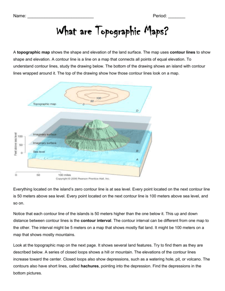
Name: ___________________________ Period: _______ What are Topographic Maps? A topographic map shows the shape and elevation of the land surface. The map uses contour lines to show shape and elevation. A contour line is a line on a map that connects all points of equal elevation. To understand contour lines, study the drawing below. The bottom of the drawing shows an island with contour lines wrapped around it. The top of the drawing show how those contour lines look on a map. Everything located on the island’s zero contour line is at sea level. Every point located on the next contour line is 50 meters above sea level. Every point located on the next contour line is 100 meters above sea level, and so on. Notice that each contour line of the islands is 50 meters higher than the one below it. This up and down distance between contour lines is the contour interval. The contour interval can be different from one map to the other. The interval might be 5 meters on a map that shows mostly flat land. It might be 100 meters on a map that shows mostly mountains. Look at the topographic map on the next page. It shows several land features. Try to find them as they are described below. A series of closed loops shows a hill or mountain. The elevations of the contour lines increase toward the center. Closed loops also show depressions, such as a watering hole, pit, or volcano. The contours also have short lines, called hachures, pointing into the depression. Find the depressions in the bottom pictures. Notice that some of the contour lines are bent into a V. Contour lines form a V on a map when they cross a valley. The V points up the valley. So if a river is flowing in the valley, the V points upstream. This is the direction from which the water is coming. Which direction do the creeks flow? If you wanted to climb most easily to the top of a mountain, which side would you choose? The map tells you. Notice in the drawing that one side of the mountain has a gentle slope and the other side has a steep slope. The topographic map shows this difference by the closeness of the contour lines. The closer the contour lines are to each other, the steeper the slope is. What is the elevation of the highest point of this island? The highest contour line is 275 meters, so the island is at least that high. Here are some other things to remember about contour lines. All contour lines eventually close, either on the map or beyond its borders. Contour lines never cross each other because one point cannot have more than one elevation. On most topographic maps, elevation is marked for every fifth contour line. 1. What type of landform is this map representing? 2. What is the contour interval of this map? 3. What do the short lines attached and pointing into the contour lines represent? 4. If you were going to climb the mountain shown in the diagram on the right, from which direction (North, East, South, or West) would you have the steepest climb? The map represents a region in the northeastern portion of the United States. 5. On which side of the lake does the land have the steepest slope? 6. What is the contour interval of this map? 7. According to the map, River Y is: a. The source of water for the lake b. At the same elevation as River X c. An outlet for the lake d. At a lower elevation than River X 8. Letters A through K are reference points on the map. Which points are located at the same elevation above sea level? 9. What is the contour interval of this map? 10. What is the highest elevation on this map? 11. What is the highest contour line? 12. What is the lowest contour line? 13. Which brook flows into Atwater Pond? 14. Which brook flows out of Atwater Pond? 15. How can you tell? 16. State the general direction in which Cottonwood Creek is flowing. 17. How do you know? 18. What is the contour interval? 19. What is the highest contour line? 20. What is the contour interval on the map of Bear Island 21. What is the contour interval on the map of Duck Island? 22. What do the markings at Point G on the map of Duck Island indicate? 23. What does the line that goes through point D on the map of Bear Island indicate? Match the contours on the left with the terrain on the right. 1. ______ 2. ______ 3. ______ 4. ______ 5. ______ 6. ______


