Link to assignment details
advertisement
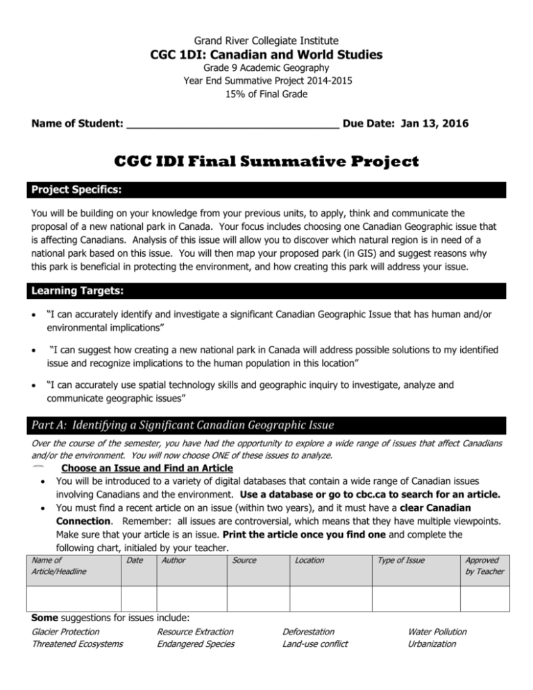
Grand River Collegiate Institute CGC 1DI: Canadian and World Studies Grade 9 Academic Geography Year End Summative Project 2014-2015 15% of Final Grade Name of Student: ________________________________ Due Date: Jan 13, 2016 CGC IDI Final Summative Project Project Specifics: You will be building on your knowledge from your previous units, to apply, think and communicate the proposal of a new national park in Canada. Your focus includes choosing one Canadian Geographic issue that is affecting Canadians. Analysis of this issue will allow you to discover which natural region is in need of a national park based on this issue. You will then map your proposed park (in GIS) and suggest reasons why this park is beneficial in protecting the environment, and how creating this park will address your issue. Learning Targets: “I can accurately identify and investigate a significant Canadian Geographic Issue that has human and/or environmental implications” “I can suggest how creating a new national park in Canada will address possible solutions to my identified issue and recognize implications to the human population in this location” “I can accurately use spatial technology skills and geographic inquiry to investigate, analyze and communicate geographic issues” Part A: Identifying a Significant Canadian Geographic Issue Over the course of the semester, you have had the opportunity to explore a wide range of issues that affect Canadians and/or the environment. You will now choose ONE of these issues to analyze. Choose an Issue and Find an Article You will be introduced to a variety of digital databases that contain a wide range of Canadian issues involving Canadians and the environment. Use a database or go to cbc.ca to search for an article. You must find a recent article on an issue (within two years), and it must have a clear Canadian Connection. Remember: all issues are controversial, which means that they have multiple viewpoints. Make sure that your article is an issue. Print the article once you find one and complete the following chart, initialed by your teacher. Name of Article/Headline Date Author Source Some suggestions for issues include: Glacier Protection Resource Extraction Threatened Ecosystems Endangered Species Location Deforestation Land-use conflict Type of Issue Approved by Teacher Water Pollution Urbanization Part B Article Summary and Analysis of Issue Article Summary. (Approximately 1 page typed) Print the whole article and complete an article summary using the format specified below. Page set up: The headline, the date, the author, the source, the place will appear at the top of your written summary. (Just as it did with your current event assignment). Write a summary of the article following the required format below. Review the marking rubric for more detail. Headline: Toxic spill: Without Warning to Local Residents Date: September 21, 2015 Required format: Author: Dr. Alena Thomas Source: Canadian Geographic Place: Williston Lake, B.C. First sentence: The issue in the article is.... Theme: Environmental Second sentence: The main people or groups involved are..... Body: (Discuss all points of view with detail. Use multiple paragraphs as needed). Creating a Sense of Place: o What is where? o Why There? o Why Care? (in short paragraphs, include all points of view). Conclusion: (Based on your issue, describe why a National Park may be a possible solution and explain how your park design relates to this issue. Also include the implications that your park may have to the local human population Part C: Design of Park Features to Help Address Your Issue Design and include three features that you will need to have in your new park design that best helps address your issue. Some examples may include: an education centre to learn more about an endangered species, or a board walk to help encourage people to stay off of sensitive ecological areas, etc. Each of these features will appear in the legend of your park map. You must have at least three. Explain each with a detailed paragraph in the chart below. Features in your park (i.e. water source, forest, education centre, wetland, boardwalk) 1) 2) 3) How is this feature related to the issue and why have you included it in the park? (detailed paragraph) Part D: ARCMAP ~ in GIS you will create a digital map of your new National Park. Application: This map will follow all mapping guidelines and will include the following: At least three layers of data (i.e. overlaying files that you are adding to illustrate features in your park). Some examples may include population density, cities, vegetation, existing national parks etc. Symbols representing each of your park features from part C above. Label important landmarks (i.e. cities, water systems, roadways etc) that exist in the area of your park Name for your park Legend which illustrates features in your park Three pictures with captions which illustrate the natural environment and/or issue in your National Park See instructions Attached. Submission Details Final Summative Projects are essential for course completion Your summative project must be word processed Please create a title page for your assignment that contains the following information: Name, Date, Course & Section, Teacher, School, Name of Park Checklist I have included the following (all in order): Title Page Part A: Printed article found on library database or CBC website with teacher approval chart Part B: Completed Article Summary (typed; 1 page in length) Part C: Completed Chart: Physical Geographic Park Features Part D: Completed Map – Printed Marking rubric for assignment Name and date on EACH page.
