grl29511-sup-0002-txts01
advertisement

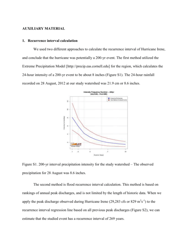
AUXILIARY MATERIAL 1. Recurrence interval calculation We used two different approaches to calculate the recurrence interval of Hurricane Irene, and conclude that the hurricane was potentially a 200-yr event. The first method utilized the Extreme Precipitation Model [http://precip.eas.cornell.edu] for the region, which calculates the 24-hour intensity of a 200-yr event to be about 8 inches (Figure S1). The 24-hour rainfall recorded on 28 August, 2012 at our study watershed was 21.9 cm or 8.6 inches. Figure S1. 200-yr interval precipitation intensity for the study watershed – The observed precipitation for 28 August was 8.6 inches. The second method is flood recurrence interval calculation. This method is based on rankings of annual peak discharges, and is not limited by the length of historic data. When we apply the peak discharge observed during Hurricane Irene (29,283 cfs or 829 m3s-1) to the recurrence interval regression line based on all previous peak discharges (Figure S2), we can estimate that the studied event has a recurrence interval of 269 years. Observed Annual Peak Discharge (1951-2010) Annual Peak Discharge (cfs) 25000 y = 5199.4ln(x) + 190.88 R² = 0.9272 20000 15000 10000 5000 0 0 10 20 30 40 50 60 Recurrence Interval (yr) Figure S2. Annual discharge vs recurrence interval regression for the sampling point. Recurrence interval R is calculated as (N+1)/M, where R is recurrence interval, N is total observation, and M is discharge rank in ascending order. 2. Sampling conditions Below table lists the sample numbers and hydrologic conditions of the six storm events monitored for this study as well as the number of monthly USGS samples that were collected from 1993-2001. As it can be clearly seen from the range of discharge covered by our samples and USGS samples, neither periodic sampling nor representative sampling for regular events can provide adequate data set for predicting change in water chemistry during extreme events (Table S1). Table S1. Sample numbers and the observed discharge range of each monitored during this study. Note that even the highest discharge seen from the regular event sampling (63.5 m-3 in May) is less than 10% of the maximum discharge observed during Hurricane Irene (27 Aug – 31 Aug). *Some post-storm samples were collected 5-8 hours after last samples in their auto-sampling program. Number of samples 16 May – 22 May 38 (DOC, TDN) Discharge range during sampling (in m3 s-1) 4.12 – 63.5 23 June – 27 June 18 (DOC, TDN) 1.37 – 4.43 4.5 18 July – 19 July 6 (DOC, TDN) 1.29 – 1.33 3 6 Aug – 10 Aug 20 (DOC, TDN) 0.99 – 1.17 4 2.5 – 829 3.5 27 Aug – 31 Aug 23 (DOC, TDN, DON) Sampling interval (in hr)* 3 23 Nov – 25 Nov 7 (DOC, TDN) 2.83 – 8.95 4 Baseflow samples 10 (DOC, TDN) 2.72 -9.83 N/A 43 (TDN, DON), 25 0.16 – 21.8 N/A USGS monthly samples (DOC) 3. Detailed description of the flux estimation model. a. Model 1 – This model simply interpolated between the 23 [DOC] and [DON] measurements made during Irene to assign a concentration for each fifteen minute interval flow measurement. The resulting concentrations were multiplied by the flow measurements then summed to yield the five day flux. This flux estimate is considered to be most accurate and serves as a reference to the other models. b. Model 2 – This model utilized LoadRunner with all available DOM concentrations except the values recorded during Hurricane Irene as data input. All sub-daily concentrations were converted into volume-weighted daily averages prior to running the model, and the resulting regression model calculated daily fluxes of both DOC and DON based on the observed daily average discharge. The premise of Model 2 and its data selection is in simulating a flux estimation for an extreme event with historic data only. The following table shows the estimated daily average concentrations of DOC and DON, and the daily discharge used for Model 2 Table S2. Daily discharge and estimated DOM concentrations used for Model 2. The concentrations are estimated by LoadRunner. 27 Aug, 2012 28 Aug, 2012 29 Aug, 2012 30 Aug, 2012 31 Aug, 2012 Avg. daily discharge in m3s-1 2.66 282 51.2 25.8 21.2 Estimated daily average [DOC] in mg C L-1 Estimated daily average [DON] in mg N L-1 1.23 1.89 1.62 1.52 1.50 0.081 0.06 0.074 0.078 0.078 c. Model 3 – Model 3 used a log-linear regression that expresses flux as a function of discharge, and incorporated all DOC and DON measurements made in 2011 and available through USGS. This model is based on more measurements as it includes all sub-daily concentrations, rather than the average daily values used in Model 2. However, Model 3 fails to take account for any seasonality in flux-discharge relationship. 4. DOM flux to Ashokan Reservoir Downstream from our sampling site, Esopus creek has an underground portal that connects Schoharie reservoir with Ashokan reservoir. The water from the portal has been suspected as a source of higher turbidity in downstream areas. Since our sampling site is upstream from the portal, our flux calculation does not account for all DOC fluxes into the reservoir. In addition to the 165 km2 of our forested study watershed, the reservoir also receives DOC flux from another 496 km2 of mostly forested watersheds. Although we do not have water chemistry data to predict the DOC flux from these areas and the portal, we here present a first order estimate of the total DOC flux to Ashokan Reservoir. The presented estimate was calculated by applying the per-area DOC flux of our study watershed to the entire catchment. Please note that this is a first-order estimate and only presented to portray the magnitude of the extreme DOC loading to receiving water bodies during Hurricane Irene. 5. Annual average discharge and DOM fluxes: 1993-2011 Figure S3. Annual average discharge and DOM fluxes for Esopus Creek, calculated by summing all daily fluxes given by LoadRunner (incorporating all available [DOM] data including the samples collected during Hurricane Irene)


