On the Road in the Lancaster area
advertisement
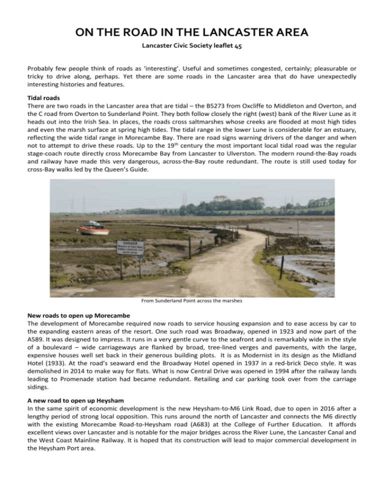
ON THE ROAD IN THE LANCASTER AREA Lancaster Civic Society leaflet 45 Probably few people think of roads as ‘interesting’. Useful and sometimes congested, certainly; pleasurable or tricky to drive along, perhaps. Yet there are some roads in the Lancaster area that do have unexpectedly interesting histories and features. Tidal roads There are two roads in the Lancaster area that are tidal – the B5273 from Oxcliffe to Middleton and Overton, and the C road from Overton to Sunderland Point. They both follow closely the right (west) bank of the River Lune as it heads out into the Irish Sea. In places, the roads cross saltmarshes whose creeks are flooded at most high tides and even the marsh surface at spring high tides. The tidal range in the lower Lune is considerable for an estuary, reflecting the wide tidal range in Morecambe Bay. There are road signs warning drivers of the danger and when not to attempt to drive these roads. Up to the 19th century the most important local tidal road was the regular stage-coach route directly cross Morecambe Bay from Lancaster to Ulverston. The modern round-the-Bay roads and railway have made this very dangerous, across-the-Bay route redundant. The route is still used today for cross-Bay walks led by the Queen’s Guide. From Sunderland Point across the marshes New roads to open up Morecambe The development of Morecambe required now roads to service housing expansion and to ease access by car to the expanding eastern areas of the resort. One such road was Broadway, opened in 1923 and now part of the A589. It was designed to impress. It runs in a very gentle curve to the seafront and is remarkably wide in the style of a boulevard – wide carriageways are flanked by broad, tree-lined verges and pavements, with the large, expensive houses well set back in their generous building plots. It is as Modernist in its design as the Midland Hotel (1933). At the road’s seaward end the Broadway Hotel opened in 1937 in a red-brick Deco style. It was demolished in 2014 to make way for flats. What is now Central Drive was opened in 1994 after the railway lands leading to Promenade station had became redundant. Retailing and car parking took over from the carriage sidings. A new road to open up Heysham In the same spirit of economic development is the new Heysham-to-M6 Link Road, due to open in 2016 after a lengthy period of strong local opposition. This runs around the north of Lancaster and connects the M6 directly with the existing Morecambe Road-to-Heysham road (A683) at the College of Further Education. It affords excellent views over Lancaster and is notable for the major bridges across the River Lune, the Lancaster Canal and the West Coast Mainline Railway. It is hoped that its construction will lead to major commercial development in the Heysham Port area. The medieval, pre-toll road/A6 route into Lancaster from the south (Burrow Road) Before the A6 Before the current A6 was built in 1824, the main road south from Lancaster followed a higher route to the west of the A6 and West Coast Mainline Railway. It is today called Burrow Road and Highland Brow as it approaches Galgate. That this was a more important medieval road than most is shown by a greater width than would be needed just to service the farms and hamlets around. A Roman road very closely paralleled the medieval Burrow Road before entering Lancaster, under what is now the Royal Lancaster infirmary and Penny Street. A new 19th century road As commerce expanded in the 19th century, speedier roads were needed before the railway reached Lancaster in 1840. The current A6 south to Preston was opened in 1824 by the Garstang and Heiring Syke Trust. This was a toll road, the tolls paying for the road’s construction on a straighter, more level alignment than its predecessor, which allowed faster journeys. The toll house at Toll Bar Crescent in Scotforth (see below, ca. 1890) is now the site of a petrol station. The principle of toll roads largely disappeared in 20th-centry Britain although it has survived in parts of Europe, and has been used in the UK more recently for major bridges, tunnels and the M6 Toll Road around Birmingham. (Lancashire CC Lantern) After the A6 came the M6 When the A6 had became inadequate for the national north-south road traffic – Lancaster was a notorious bottleneck in the 1930s – what is now the M6 was built, planned by Lancashire County in the interwar period. The first section was around Preston and opened in December 1958, followed by the section bypassing Lancaster (now Junctions 33 to 35) in April 1960. It was the UK’s third stretch of motorway, the London to Birmingham M1 having opened in November 1959. The most impressive structure was the 400-feet (120-metres) bridge over the River Lune. At its centre is a graceful single arch of 230 ft (69m) built in two parallel sections of reinforced concrete. Junction 34, near the bridge, was built to a less-than-normal specification and was rebuilt, to open in 2016, with a new bridge to the west to link the M6 to the new Heysham link road. A road not to drive along Technically Nip Hill (left), in central Lancaster between China Street and St Mary’s Parade, is still a road. But it is so narrow, cobbled, twisting and steep that one really should not drive along it, though no notices prohibiting this are visible. It is a survivor from the many alleys and ginnels for handcarts and pedestrians that characterised medieval Lancaster. Roads worth driving along Finally some roads you should drive, just for their scenic value. The roads along the Lune Valley, on either the south side (the A683) or the quieter north side. Many of the roads around Silverdale and Arnside. Littledale Road, from Little Fell Road (east of Lancaster) to Caton. Private roads The Haverbreaks estate in Lancaster is an example of an area where the houses are serviced by a private road – that is, one not maintained by the local council but by the residents who pay for its upkeep through their Residents Association. Other examples include The Grove in Bowerham and Eden Park in Scotforth. Text – Gordon Clark. Photographs – Gordon Clark unless otherwise acknowledged. Published by Lancaster Civic Society (©2015). www.lancastercivicsociety.org citycoastcountryside.co.uk

