Topic A – Village Settlers
advertisement
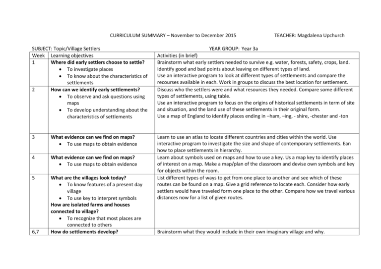
CURRICULUM SUMMARY – November to December 2015 SUBJECT: Topic/Village Settlers Week Learning objectives 1 Where did early settlers choose to settle? To investigate places To know about the characteristics of settlements 2 How can we identify early settlements? To observe and ask questions using maps To develop understanding about the characteristics of settlements 3 What evidence can we find on maps? To use maps to obtain evidence 4 What evidence can we find on maps? To use maps to obtain evidence 5 What are the villages look today? To know features of a present day village To use key to interpret symbols How are isolated farms and houses connected to village? To recognize that most places are connected to others How do settlements develop? 6,7 TEACHER: Magdalena Upchurch YEAR GROUP: Year 3a Activities (in brief) Brainstorm what early settlers needed to survive e.g. water, forests, safety, crops, land. Identify good and bad points about leaving on different types of land. Use an interactive program to look at different types of settlements and compare the recourses available in each. Work in groups to discuss the best location for settlement. Discuss who the settlers were and what resources they needed. Compare some different types of settlements, using table. Use an interactive program to focus on the origins of historical settlements in term of site and situation, and the land use of these settlements in their original form. Use a map of England to identify places ending in –ham, –ing, - shire, -chester and -ton Learn to use an atlas to locate different countries and cities within the world. Use interactive program to investigate the size and shape of contemporary settlements. Ean how to place settlements in hierarchy. Learn about symbols used on maps and how to use a key. Us a map key to identify places of interest on a map. Make a map/plan of the classroom and devise own symbols and key for objects within the room. List different types of ways to get from one place to another and see which of these routes can be found on a map. Give a grid reference to locate each. Consider how early settlers would have traveled form one place to the other. Compare how we travel various distances now for a list of given routes. Brainstorm what they would include in their own imaginary village and why. To recognize that settlements have specific features and are located in response to physical features and human choice Use checklist of items to include in their village. Create a map of and imaginary village. Present their map to the rest of the class.
