Annex to the voluntary agreement
advertisement
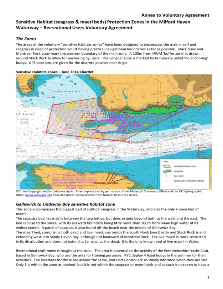
Annex to Voluntary Agreement Sensitive Habitat (seagrass & maerl beds) Protection Zones in the Milford Haven Waterway – Recreational Users Voluntary Agreement The Zones The areas of the voluntary “sensitive habitats zones” have been designed to encompass the main maerl and seagrass in need of protection whilst having practical navigational boundaries as far as possible. Stack buoy and Montreal Rock buoy mark the western boundary of the main zone. A 100m from HWM ‘buffer zone’ is drawn around Stack Rock to allow for anchoring by users. The Longoar zone is marked by temporary pellet ‘no anchoring’ buoys. GPS positions are given for the discrete patches near Angle. Sensitive Habitats Zones – June 2014 Chartlet ©Crown Copyright and/or database rights. Chart reproduced by permission of Her Majesty’s Stationary Office and the UK Hydrographic Office (www.ukho.gov.uk). Provided under special licence from Natural Resources Wales. Gelliswick to Lindsway Bay sensitive habitat zone This zone encompasses the biggest bed of subtidal seagrass in the Waterway, and also the only known bed of maerl. The seagrass bed lies mainly between the two jetties, but does extend beyond both to the west and the east. The bed is close to the shore, with its seaward boundary being little more than 200m from mean high water at its widest extent. A patch of seagrass is also found off the beach near the middle of Gelliswick Bay. The maerl bed, comprising both dead and live maerl, surrounds the South Hook (west) jetty and Stack Rock island extending west into Sandy Haven Bay, although not landward of Montreal Rock. The live maerl is more restricted in its distribution and does not extend as far west as the dead. It is the only known bed of live maerl in Wales Recreational craft move throughout the zone. The area is essential to the activity of the Pembrokeshire Yacht Club, based in Gelliswick Bay, who use the area for training purposes. PYC deploy 4 fixed buoys in the summer for their activities. The locations for these are always the same, and Port Control are routinely informed when they are laid. Only 1 is within the zone as marked, but it is not within the seagrass or maerl beds and as such is not seen to have a 1 Annex to Voluntary Agreement detrimental effect and so will be allowed within this Agreement to remain. It should be noted that allowance is made in the Agreement for temporary race marks. A floating pontoon has been placed in the centre of the bay during the summer by PCC in the past, but this has not been provided for the last 2 years and is unlikely to reappear (if it does arrangements will be made to ensure that this is not located within the seagrass). The area around Stack Rock is popular as an anchorage for anglers. A buffer zone of 100m around the island allows for continued use. Longoar Bay sensitive habitat zone This zone is solely for the protection of a small bed of seagrass of variable density (leading to patchiness). This is really the only zone within which recreational anchoring is currently known to occur due to it being one of the few (if not the best) sheltered anchorages in this part of the Waterway. Frequency of anchoring is not thought to be great, and is mostly restricted to fine summer days. Vessels that anchor within the seagrass itself tend to be small (often power) craft rather than the bigger sailing boats as there is a restricted depth of water. Allowance is made for close anchoring to the beach in the north of the bay. The provision of visitor buoys (along the lines of those provided by Natural Resources Wales within the Skomer Marine Nature Reserve to protect the seagrass bed in North Haven) on the outer edge of the zone would be a useful facility to users, and this will be explored during the winter of 2013. Angle Point and Ellen’s Well sensitive habitat zone This zone, rather than comprising one ’block’, actually consists of a few discrete patches of seagrass. From west to east, the GPS positions are as follows: Patch 1 – 51deg 41.41min N, 5deg 5.02min W Patch 2 – 51deg 41.41min N, 5deg 4.91min W Patch 3 – 51deg 41.41min N, 5deg 4.85min W Patch 4 – 51deg 41.36min N, 5deg 4.61min W Positions are approximate mid points of patches having approx. diameters of 50m. None of these patches overlap with the area used for recreational moorings and occasional anchoring, which lies to the east of the lifeboat slip and is at least 100m outside the MLW line. However, local fishermen do use the area for lobster cages and prawn pots. They will be provided with seagrass positions to avoid on a voluntary basis. Rationale for the creation of the sensitive habitat zones Further information on where the protection zones have come from and the need for them can be found at www.pembrokeshiremarinesac.org.uk/english/special/inlets_c.htm In brief, the maerl and seagrass beds within the Milford Haven waterway are within the Pembrokeshire Marine Special Area of Conservation (SAC) which is protected by European and UK law. They are currently in unfavourable condition; mooring and anchoring activity can contribute to their deterioration. The law requires proactive management in order to help improve the condition of these seabed habitats and prevent any further deterioration by taking necessary measures to safeguard them for the future. Promulgation of the Agreement MHUA will strive to inform all its members about the Agreement and advise them to comply on a voluntary basis. The Port of Milford Haven will assist in promulgation of the agreement. The agreement will be sent to all mooring holders when issuing mooring licenses in the spring of 2015. The Water Ranger will endeavour to raise awareness with users (both local and visitor) on an ad hoc basis. The SAC Officer will strive to: 2 Annex to Voluntary Agreement Incorporate the Agreement into the annual Leisure Guide issued by the Port of Milford Haven (for 2015 – an insert could perhaps be produced for 2014); Formulate and help to implement an awareness raising campaign to publicise the Agreement with all users (including event(s), information flyers, posters and website links etc.). Monitoring and Review To help inform the effectiveness of the Agreement in achieving conservation gain for the maerl and seagrass habitats within the protection zones, monitoring of the seabed itself and of any co-located activities is required. Ecological monitoring of the maerl and seagrass is undertaken by Natural Resources Wales and is constrained by annual budgets. At the very least, extent of the beds should be surveyed. Activity monitoring will ultimately be a mixture of; Information provided by users themselves (most likely from relevant Clubs and Associations). Information from Port of Milford Haven (registered moorings etc.) Water Ranger observations and reports (ad hoc) This agreement will take effect from the start of the 2014 season and will be kept under review. Further information Further information in support of this project can be found at: www.pembrokeshiremarinesac.org.uk/english/special/inlets_c.htm The SAC Officer is also involved in seagrass-friendly mooring development, and seagrass impacts research. If you have any specific queries, or can contribute in any way to this project please contact Sue Burton, Pembrokeshire Marine SAC Officer, Tel: 01646 696108, email: sacofficer@pembrokeshiremarinesac.org.uk by Sue Burton, Pembrokeshire Marine SAC www.PembrokeshireMarineSAC.org.uk 2014 3
