Central Corridor/Piedmont Region
advertisement
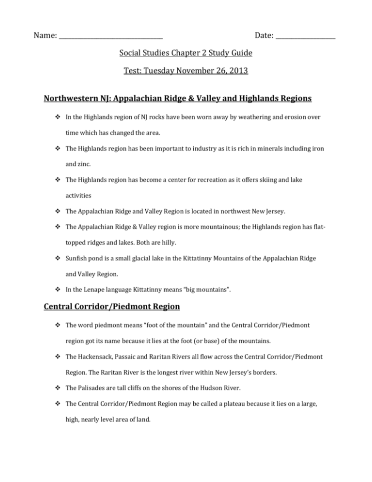
Name: _________________________________ Date: ___________________ Social Studies Chapter 2 Study Guide Test: Tuesday November 26, 2013 Northwestern NJ: Appalachian Ridge & Valley and Highlands Regions In the Highlands region of NJ rocks have been worn away by weathering and erosion over time which has changed the area. The Highlands region has been important to industry as it is rich in minerals including iron and zinc. The Highlands region has become a center for recreation as it offers skiing and lake activities The Appalachian Ridge and Valley Region is located in northwest New Jersey. The Appalachian Ridge & Valley region is more mountainous; the Highlands region has flattopped ridges and lakes. Both are hilly. Sunfish pond is a small glacial lake in the Kittatinny Mountains of the Appalachian Ridge and Valley Region. In the Lenape language Kittatinny means “big mountains”. Central Corridor/Piedmont Region The word piedmont means “foot of the mountain” and the Central Corridor/Piedmont region got its name because it lies at the foot (or base) of the mountains. The Hackensack, Passaic and Raritan Rivers all flow across the Central Corridor/Piedmont Region. The Raritan River is the longest river within New Jersey’s borders. The Palisades are tall cliffs on the shores of the Hudson River. The Central Corridor/Piedmont Region may be called a plateau because it lies on a large, high, nearly level area of land. Many of New Jersey’s largest cities are in the Central Corridor/Piedmont region including Paterson, Newark, Elizabeth, Jersey City, and New Brunswick. Over 50% of New Jersey’s population lives in the Central Corridor Piedmont region. Elizabeth has become an industrial city. It has grown as a transportation center as boats traveled between New York City and there. Transport expanded with railway lines and port facilities for cargo ships. Paterson was the first planned industrial city in the United States. Atlantic Coastal Plain The Atlantic Coastal Plain region covers the largest portion of the state (three fifths of the state). The entire Atlantic Coastal Plain is a lowland area where water is a key feature. A barrier island is formed by waves depositing ridges of sand. The Inner Coastal Plain has fertile farmland. The very fertile soil is due to the Delaware River. Farms are able to produce many different types of fruits and vegetables due to the fertile soil. The Outer Coastal Plain has salt marshes, pine forests and sandy beaches. Fresh water lies below the Pinelands in one of the country’s largest reservoirs. Congress created the New Jersey Pinelands National Reserve to protect the fresh water in the Pinelands area. The population density in the Inner Coastal Plain is much higher (more people live there). The Outer Coastal Plain is a greater tourist attraction. Many towns along the Jersey Shore are resort towns. Visitors love the sandy beaches and boardwalks that have rides, food and games. Many of these resort towns have hotels, restaurants, theaters and shops. A major resort town on the Jersey Shore, Atlantic City, has casinos and many other attractions. The Pinelands is the largest area of open space in the Middle Atlantic region of the United States. There are pine, cedar and oak forests, cedar swamps and slow moving streams stretching over the one of the country’s largest fresh water reservoirs. Other topics: Suburban, Urban and Rural Areas o A suburb is a community at the edge of or near a city. Usually people have more space between their houses, there are parks and some commercial centers (shopping malls). Many people who live in suburbs commute to urban areas. Maplewood is a suburb and many people who live here commute to New York. o Generally an area with a low population density (few people living there) is rural. o An urban area has the characteristics of a city. Many people live in these areas (high population density) often in apartments and close together. Urban Areas are industrial with many job opportunities. Elevation maps (Be able to read one)
