Ex4Soln
advertisement
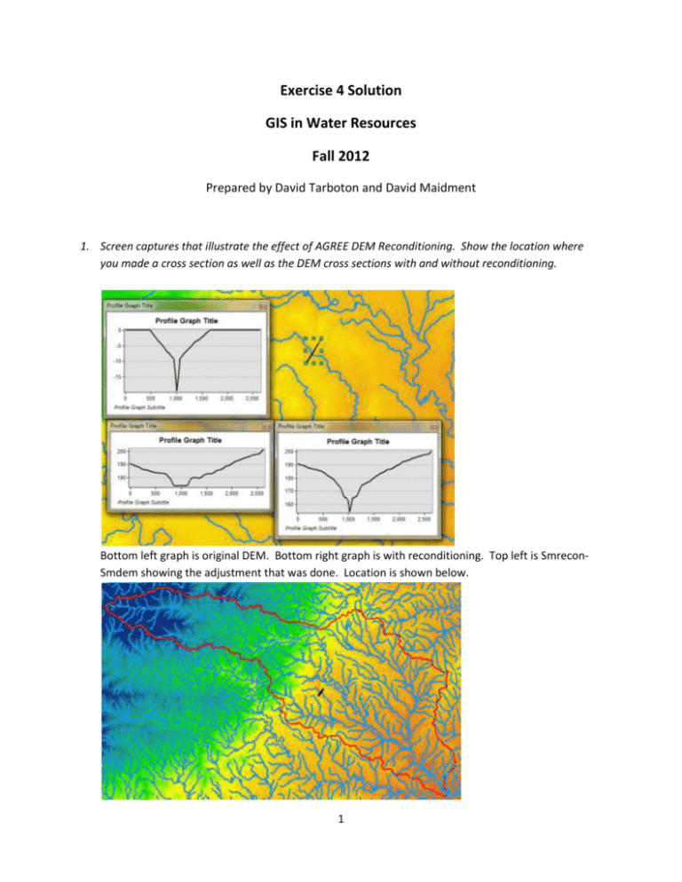
Exercise 4 Solution GIS in Water Resources Fall 2012 Prepared by David Tarboton and David Maidment 1. Screen captures that illustrate the effect of AGREE DEM Reconditioning. Show the location where you made a cross section as well as the DEM cross sections with and without reconditioning. Bottom left graph is original DEM. Bottom right graph is with reconditioning. Top left is SmreconSmdem showing the adjustment that was done. Location is shown below. 1 2. Number of stream grid cells in FlowLineReclas and estimates of channel length and drainage density. Opening the attribute table of FlowLineReclas gives the number of stream grid cells as 241928. This is over a total number of grid cells of 11581224+241928 = 11823152. (This could also have been obtained from number of rows and columns 4334*2728). Assuming a length of each grid cell of 30 m (per the instructions), L = 241928 * 30 = 7.257 x 10⁶ m. Cell size is 30 m x 30 m = 900 m2. Area = 11823152 * 900 = 10.64 x 10⁹ m2 Drainage density = L/Area = 7.257 x 10⁶ /10.64 x 109 = 0.000682 m-1 = 0.682 km-1. Note. This is actually not a very good estimate. The Feature to Raster function identifies any grid cell occupied be even a small length of flowline as on the raster, resulting in "fat" streams that sometimes have a stair step pattern. The result when multiplied by cell size is an over-estimate. This over-estimation could have been reduced if we had used the "Thin" tool. 3. Volumes of earth removed estimated from (a) layer properties of diff and (b) from estimates of channel length and cross section area. Comment on the differences. a) The raster calculation smdem - smrecon was performed and the average of the resultant grid is 2.779 m. This applies to a 900 m2 area, representing a removal volume of: 2.779 * 900 * 11823152 = 29.57 x 10⁹ m3. b) The cross section area of the swath removed during reconditioning is 1/2*1000 * 10 + 30 * 10 = 5300 m2. 2 Therefore volume removed is: 5300 * 7.257 x 106 = 38.46 x 10⁹ m3. This is more than the estimate in (a) above due to the overestimate of length reflected in the above. There is also a small discrepancy due to the area of DEM with elevation values not filling the full grid which was used in the above calculations. [Any set of numbers close to these that have used reasonable approximations and justified methodology is acceptable] 4. Make a screen capture of the attribute table of fdr and give an interpretation for the values in the Value field using a sketch. Following is the attribute table of FDR. The values should be interpreted according to the figure at the right and the count gives the number of grid cells with each flow direction value. 5. Report the drainage area of the San Marcos basin in both number of 30 m grid cells and km2 as estimated by flow accumulation. 3 The area of the San Marcos basin is 3911496 grid cells = 3911496 * 900 = 3. 520 x 109 m2 = 3520 km2 6. Report the name of the most downstream HUC 12 subwatershed in the San Marcos Basin. Report the area of the most downstream HUC 12 subwatershed determined from flow accumulation, from the ACRES attribute and from Shape_Area. Convert these area values to consistent units. Comment on any differences. Following is the output from identify on the most downstream HUC 12 subwatershed. The name of most downstream HUC 12 subwatershed: Smith Creek-San Marcos River 4 Note that this is within the Lower San Marcos HUC 10, but the HUC 12 name is Smith Creek-San Marcos. Area draining in to most downstream HUC is: 3745870 grid cells = 3745870 * 900 = 3.371 x 10⁹ m2. Taking the difference with the area leaving this HUC 12 subwatershed, I get (3.520 - 3.371) x 109 m2= 0.149 x 10⁹ m2 = 0.149 x 10⁹ /4047 = 36820 acres. This compares well with the 36726 acres reported in the ACRES attribute. The Shape_area for this subwatershed of 0.1486 x 10⁹ m2, agrees with this. 5 7. Describe (with simple illustrations) the relationship between StrLnk, DrainageLine, Catchments and CatchPoly attribute and grid values. What is the unique identifier in each that allows them to be relationally associated? 6 8. A layout showing the stream network and catchments attractively symbolized with scale, title and legend. The symbology should depict the stream order for each stream. 9. Indicate the field in the gages table that is associated with values in the wshedG. Give the area in number of grid cells and km2 of each gauge subwatershed. Add these as appropriate to give the total area draining to each gauge and compare to the DA_SQ_MILE values from the USGS for these gauges. The field OBJECT_ID defines the subwatershed zones for each gage. This is because I selected OBJECTID as the pour point field when running Snap Pour Point (following the instructions on page 30) 7 The number of cells associated with each subwatershed is shown in the Attribute table for the WshedG grid as given below. To associate these cell counts with the appropriate gage, I used the following join on the gages table. 8 Note that I used the OBJECTID field in the Gages table and joined this on to the Value field on the wshedG value attribute table because OBJECTID's from Gages were written as grid values in wshedG. I then exported the joined table to a .txt file (its comma delimited), opened it in Excel and deleted unwanted columns. The cell size on the grids being used for this solution is 30m, so the area of each subwatershed in square km = number of cells * (900/1000000). The areas of the watersheds for the gages are found by summing the areas of the subwatersheds for all upstream area draining to that gage. To help with figuring out which areas flow to which gages, the colors in the map are shown in the spreadsheet below. The Watershed areas were reported in square miles (The conversion used 1.609344 km in a mile). The resulting differences between the DEM-delineated areas and those in the gage feature class DA_SQ_Mile field are small, as can be seen from the table below. (This is an embedded object so if reading online you can click to see formula's) 9 OBJE CTID 1 2 3 4 5 6 7 8 SITE_NO 08171000 08171300 08170500 08172400 08172500 08173000 08172000 08173500 DA_SQ_ STATION_NM MILE Blanco Rv at Wimberley, TX 355 Blanco Rv nr Kyle, TX 412 San Marcos Rv at San Marcos, TX 48.9 Plum Ck at Lockhart, TX 112 Plum Ck nr Lockhart, TX 189 Plum Ck nr Luling, TX 309 San Marcos Rv at Luling, TX 838 San Marcos Rv at Ottine, TX 1249 Count 1022117 164930 141649 319408 211916 366431 1087003 309029 SubWshed Area (km2) 919.91 148.44 127.48 287.47 190.72 329.79 978.30 278.13 ObjID's of all upstream Watershed Color (inclusive) Area (mi2) Difference Beige 1 355.18 -0.18 Green 1,2 412.49 -0.49 Dark blue 3 49.22 -0.32 Orange 4 110.99 1.01 Light blue 4,5 184.63 4.37 Crimson 4,5,6 311.96 -2.96 Med blue 1,2,3,7 839.44 -1.44 Brown 1,2,3,4,5,6,7,8 1258.78 -9.78 (This is an embedded object so if reading online you can click to see formula's) 10. A table giving for each USGS gauge the number of upstream stream links, the total length of upstream stream links, the total upstream area, drainage density (total length/total area), number of downstream links along path to outlet, distance to outlet along the streams. To define a geometric network in ArcGIS lines as well as nodes may be input. We will build a network from the DrainageLine feature class and a single node that is to be a sink at the outlet. To ensure that we have a point right on the outlet we use Feature Vertices to Points with the DANGLE option to create a feature class with a point at the end point (each dangling point) of the network then we select and export the one at the downstream outlet as OutletSink. The network was then built using the instructions on pages 30-38. There is one tricky part and that is the editing of the OutletSink attribute table to have an AncillaryRole value of 2, which corresponds to Sink. This is most easily done by opening the Attribute table of OutletSink and editing the value to a numeric value of 2. This is not intuitive. You just have to know that 2 corresponds to sink. The operations using the Attributes editor that opens on the right I could not make work reliably and sometimes it is hard to even get them to appear. Once you have the table AncillaryRole attribute value set to 2 you can (while still editing, because setting direction is regarded as an editing operation) click on the Set Flow direction button and this should process the network to make all edges flow towards the OutletSink point which is the designated outlet. With arrows pointed down each link the network is ready for analysis and you can stop editing. To be able to determine catchment area as well as channel length for upstream networks I wanted to include catchment area as an attribute of DrainageLine. This is a bit tricky because of the Many to One relationship between catchment polygon features and drainage line features illustrated on page 11 above. I therefore used the Dissolve tool with the following inputs. Note that I selected grid_code as the Dissolve_Field. This results in combining all separate shapes that have the same grid_code. I also chose to aggregate Shape_Area using the SUM to get the sum of shape area's. This turned out to be redundant as the system actually computed a new Shape_Area that is equivalent. 10 The result is: Note that there are now 434 shapes corresponding to the number of links. I then used the following join on the DrainageLine attribute table to associate these areas with DrainageLine features. 11 Note that grid_code was used as the join field. I then successively placed an edge flag on the edge associated with each USGS stream gauge and performed a trace upstream to select the upstream part of the network. 12 I then used statistics of selected Shape_Length and Shape_Area to determine the number of links, total length and drainage area of the network draining to each gauge. These were recorded in the table below. I then performed a trace downstream and used statistics of selected Shape_Length to determine the distance to the outlet along the streams. Following are screen grabs of the statistics results. Blanco Rv at Wimberley, Tx (upstream) Blanco Rv at Wimberley, Tx (downstream) Blanco Rv nr Kyle, TX (upstream) 13 Blanco Rv nr Kyle, TX (downstream) San Marcos Rv at San Marcos, TX (upstream) San Marcos Rv at San Marcos, TX (downstream) Plum Ck at Lockhart, TX (upstream) 14 Plum Ck at Lockhart, TX (downstream) Plum Ck nr Lockhart, TX (upstream) Plum Ck nr Lockhart, TX (downstream) Plum Ck nr Luling, TX (upstream) 15 Plum Ck nr Luling, TX (downstream) San Marcos Rv at Luling, TX (upstream) San Marcos Rv at Luling, TX (downstream) San Marcos Rv at Ottine, TX (upstream) 16 San Marcos Rv at Ottine, TX (downstream) (As a check) Total Total Total Drainage Number of length DA_SQ_ links upstream upstream upstream Density SITE_NO STATION_NM MILE upstream (km) area (km2) area (mi 2) (km-1) 08171000 Blanco Rv at Wimberley, TX 355 135 358.50 924.1 356.8 0.388 08171300 Blanco Rv nr Kyle, TX 412 151 430.58 1074.1 414.7 0.401 08170500 San Marcos Rv at San Marcos, TX 48.9 13 62.80 128.4 49.6 0.489 08172400 Plum Ck at Lockhart, TX 112 30 138.97 299.05 115.5 0.465 08172500 Plum Ck nr Lockhart, TX 189 54 219.94 479.6 185.2 0.459 08173000 Plum Ck nr Luling, TX 309 86 375.07 809.2 312.4 0.464 08172000 San Marcos Rv at Luling, TX 838 289 961.35 2190.7 845.8 0.439 08173500 San Marcos Rv at Ottine, TX 1249 404 1442.5 3260.8 1259.0 0.442 Number of Distance links on to outlet path downstre downstream am (km) 37 170.31 31 144.67 30 128.37 25 90.91 20 73 16 62.88 13 59.59 10 38.04 (This is an embedded object so if reading online you can click to see formula's) Note that length and area results are over-estimates relative to the USGS gauge because the network trace includes the entire link including the gauge. 11. A layout illustrating the longest flow path in the San Marcos watershed and giving the length in km. Screen shot giving longest path length along downstream trace 17 18 12. A screen capture that shows the watershed delineated by the online tool. 13. A table giving the minimum elevation, Maximum elevation and Area determined from the Online tool. Compare the area to what you obtained from the DEM in this exercise. Information from Watershed Delineated Online Area Area from this exercise Min Elevation Max Elevation 3507.6 x 106 m2 3520 x 106 m2 79 m 618 m 19
