IVATF.2.IP.006.5.en
advertisement
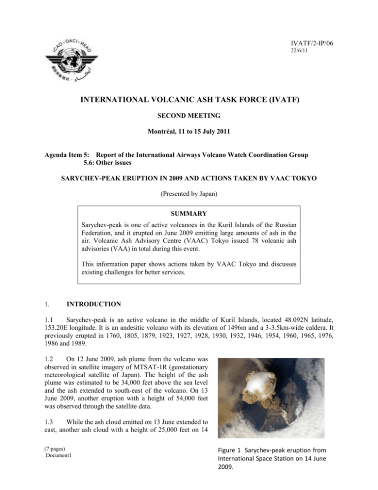
IVATF/2-IP/06 22/6/11 INTERNATIONAL VOLCANIC ASH TASK FORCE (IVATF) SECOND MEETING Montréal, 11 to 15 July 2011 Agenda Item 5: Report of the International Airways Volcano Watch Coordination Group 5.6: Other issues SARYCHEV-PEAK ERUPTION IN 2009 AND ACTIONS TAKEN BY VAAC TOKYO (Presented by Japan) SUMMARY Sarychev-peak is one of active volcanoes in the Kuril Islands of the Russian Federation, and it erupted on June 2009 emitting large amounts of ash in the air. Volcanic Ash Advisory Centre (VAAC) Tokyo issued 78 volcanic ash advisories (VAA) in total during this event. This information paper shows actions taken by VAAC Tokyo and discusses existing challenges for better services. 1. INTRODUCTION 1.1 Sarychev-peak is an active volcano in the middle of Kuril Islands, located 48.092N latitude, 153.20E longitude. It is an andesitic volcano with its elevation of 1496m and a 3-3.5km-wide caldera. It previously erupted in 1760, 1805, 1879, 1923, 1927, 1928, 1930, 1932, 1946, 1954, 1960, 1965, 1976, 1986 and 1989. 1.2 On 12 June 2009, ash plume from the volcano was observed in satellite imagery of MTSAT-1R (geostationary meteorological satellite of Japan). The height of the ash plume was estimated to be 34,000 feet above the sea level and the ash extended to south-east of the volcano. On 13 June 2009, another eruption with a height of 54,000 feet was observed through the satellite data. 1.3 While the ash cloud emitted on 13 June extended to east, another ash cloud with a height of 25,000 feet on 14 (7 pages) Document1 Figure 1 Sarychev-peak eruption from International Space Station on 14 June 2009. IVATF/2-IP/06 -2- June moved to west. The ash clouds spread such a wide area that many airplanes were forced to change their routes or obliged to return. 2. ACTIONS TAKEN BY VAAC TOKYO 2.1 VAAC Tokyo is responsible for issuing VAAs of volcanoes in the north-western pacific region, including Kamchatka, Kuril Islands, Japan and Philippines. Sarychev-peak is one of the volcanoes for which VAAC Tokyo should issue VAAs. 2.2 It issued the first VAA for Sarychev-peak at 0649 UTC on 12 June 2009, and issued following VAAs every 6 hours while ash clouds were observed in satellite imagery. From 0852 UTC 16 June, it issued VAAs every 3 hours to inform ATM on current status of ash cloud more frequently. 2.3 Sakhalin Volcanic Eruption Response Team (SVERT) monitors volcanoes of the Central and Southern Kuril Islands. However, no ground observation was available for Sarychev-peak. Since ground-based and airborne observation was not available at that time, space-based observation (satellite) was the only source of the status of ash clouds. 2.4 VAAC Tokyo could monitor almost all parts of volcanic ash clouds during the eruption as far as they were in its area of responsibility, because they were on the middle latitude area and cumulonimbus or other meteorological clouds, which might obstacle to detect ash clouds, were not dominant at that time. 2.5 Some part of volcanic ash clouds from Sarychev-peak extended east beyond the end of MTSAT monitoring area. VAAC Anchorage and VAAC Washington generously took over responsibility of monitoring these ash clouds as well as issuing VAA for them. 2.6 To detect and track ash clouds, split window technique (Prata, 1989) is applied in most of VAACs. This technique uses the difference of two infrared windows. -3- IVATF/2-IP/06 Figure 2 ― Temperature of Blackbody (TB) difference between 2 infrared rays 2.7 MTSAT has two infrared channels, one has window of 10.3-11.3 micrometers (IR1) and the other has 11.5-12.3 micrometers (IR2). The former wavelength ray is absorbed by quarts-silicon particles such as volcanic ash, rather than the latter one. In case of thin Cirrus, it is vice versa (Fig. 2). Therefore if ash clouds are dominant in the air, IR1-IR2 value is negative. Fig. 3 shows a snapshot of volcanic ash in a split image. In VAAC Tokyo, negative value (volcanic ash) is shown as white, which indicated existence of volcanic ash clouds. IVATF/2-IP/06 -4- Figure 3 ― Ash clouds from Sarychev-peak in an MTSAT-1R split image on 16 June 2009 2.8 Once they were not observed in the satellite imagery, VAAC Tokyo stopped issuing VAAs on the volcano at 0252 UTC on 23 June. After that, small ash plume was observed June 24 and July 27. VAAC Tokyo issued VAAs upon these ash clouds, found it didn't last long. 2.9 Since VAAC Tokyo could monitor and follow ash clouds emitted from the volcano during a series of eruption, the term OBS VA CLD (observed volcanic ash clouds) in every VAA described the area covered by volcanic ash clouds actually observed by the satellite. It should be noted that it is not always true. In the report of the 2nd meeting of IAVWOPSG, it is described as follows. 5.4.8 [...] The group noted that during the Grimsvötn eruption in Iceland (November 2004), the extent of the ash cloud had been almost entirely based on estimations (except for in the immediate vicinity of the volcano). To cater for such cases, the group agreed that Element 13 of the volcanic ash advisory (entitled "OBS ASH CLOUD") could also be based on an estimation. […] 2.10 FCST VA CLD (forecast volcanic ash clouds) in every VAA indicated the area of future volcanic ash position estimated by numerical calculation. VAAC Tokyo ran its dispersion model every time after it determined current area of volcanic ash. Initial condition of volcanic ash was set as it is seen in the satellite imagery. 2.11 VAAC Tokyo measures the height of the top of ash clouds by using equivalent blackbody temperature (TBB) derived from infrared imagery. As clouds drift upward, the temperature becomes as same as that of surrounding air. In infrared satellite image, the lower the temperature of clouds is, the brighter they are seen. By measuring the brightest point of the ash clouds and comparing with the temperature-height relation derived from grid point value (GPV), the highest point of the ash clouds can -5- IVATF/2-IP/06 be estimated. However, TBB method is not applicable for well dispersed volcanic ash because the top of the ash cloud is obscure and its height tends to be underestimated. 2.12 The gravity of fine ash particle is weak. It takes several days for an ash particle of micrometer in diameter to fall 10 kilometres height. The more particles of ash are small, the longer they remain their height. Although ash clouds have been dispersed well and the height of the clouds looks lower, fine ash particles probably remain its height. Therefore, VAAC Tokyo had reported height of ash clouds as the highest value which was measured at the beginning of eruption, until the clouds dissipated and could not be seen on satellite imagery. Figure 4 ― Current volcanic ash information based on MTSAT-1R monitoring 2.13 Figure 4 above shows ash clouds distribution at 0459 UTC, 16 June 2009. About 36 hours had passed since left part of the cloud observed on satellite imagery, and it extends west, covered Sakhalin and eastern part of Russia. Figure 5 below shows an ash cloud layer observed from an airplane from Frankfurt to Tokyo around 0300 UTC, 16 June 2009, at the edge of the estimated cloud. It reported that the cloud was seen at the height of 30,000 feet. It means that the estimated position and height of the ash cloud was appropriate on satellite imagery. -6- IVATF/2-IP/06 Figure 5 ― Ash layer (between arrows) seen from an airplane (at red-cross point on Figure 4) 3. DISCUSSION 3.1 Monitoring ash clouds via satellite image has several difficulties: Limited coverage; since geostationary satellites sit above the equator, they cannot monitor high latitude areas. More than 60 degrees latitude area cannot be seen well because of the projection angle of scanners. That is a great disadvantage for monitoring ash clouds from volcanoes located high latitude areas, e.g. Iceland and northern Kamchatka. Polar-orbit satellite may cover such high latitude area, however, its special and time monitoring windows are very limited compare to that of geostationary satellites. Difficulty of ash cloud detection; in some cases, cumulonimbus and/or cirrus can be seen as volcanic ash clouds. As ash clouds disperse, it is getting difficult to discriminate ash clouds from meteorological clouds. Continuous monitoring is essential to detect and track volcanic ash. Uncertainty of lower part of ash clouds; because satellites observe ash clouds from the top, the lower part of ash clouds is uncertain from satellite data. Existence of ash in the lower part is crucial for taking off and landing of airplanes. 3.2 Despite the above-mentioned difficulties, space-based observation can monitor considerably wide area compared with ground and in-situ (airborne) observation, and can detect ‘actual’ volcanic ash clouds. Therefore, it is the only reliable way to monitor wide-spread volcanic ash clouds. 3.3 Tokyo VAAC reports current VAA clouds according to 'observed' ash clouds via satellite, based on a principle that visible ash always includes ash concentration area. However, if invisible ash is still hazardous to airplanes, we cannot apply satellite observation for monitoring current status of volcanic ash clouds. On the contrary, if visible ash area is much larger than ash concentration area, informing ash areas based on satellite image is overreacting. If latter case is true, we have to develop -7- IVATF/2-IP/06 a method to extract true ash concentration area from visible ash in a satellite image. In this regard, it is very essential to determine the definition of ash concentration area. 3.4 To forecast future position of ash clouds, it is important to develop a dispersion model which can start from any state of ash and forecast future state of ash accurately. VAAC Tokyo runs its dispersion model from observed volcanic ash, not simply from initial state of the eruption. It enables us to make forecast considering actual status of current ash clouds. However, the result of forecast tends to be overestimated compared with actual monitoring result of 6, 12, 18 hours later. 3.5 The ICAO North Atlantic Systems Planning Group (NAT SPG), at its forty-first meeting in 2005, had expressed concern regarding the length of volcanic ash advisories which could inundate airground voice channels. In this regard, VAAC Tokyo uses less than 8 points to depict observed/forecast ash clouds in its VAA. However, the less the number of points is, the less accurate the area of ash clouds would be illustrated. It is also important to find an appropriate number of points which are both sufficiently portray the shape of ash clouds and not causing communication disruption 4. ACTION BY THE IVATF 4.1 The IVATF is invited to note the contents of this information paper. — END —

