SOL 1.2b North American Regions
advertisement
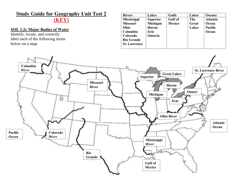
Study Guide for Geography Unit Test 2 (KEY) SOL 1.2c Major Bodies of Water Identify, locate, and correctly label each of the following terms below on a map. Rivers Mississippi Missouri Ohio Columbia Colorado Rio Grande St. Lawrence Lakes Superior Michigan Huron Erie Ontario Gulfs Gulf of Mexico Columbia River Lakes The Great Lakes Oceans Atlantic Ocean Pacific Ocean St. Lawrence River Great Lakes Superior Missouri River Huron Ontari o Michigan Erie Ohio River Atlantic Ocean Pacific Ocean Colorado River Mississippi River Rio Grande Gulf of Mexico SOL 1.2c Significance of Major Bodies of Water in North America ___J___ Gulf of Mexico A Inland port cities grew in this area ___B___ Columbia River B Explored by Lewis and Clark ___E___ Mississippi River ___D__ Atlantic Ocean ___I___ Pacific Ocean __H___ Ohio River __A___ Great Lakes C Connects the Great Lakes to the Atlantic D Served as an ocean highway between Europe and North America E The most famous river in America and used to transport farm and industrial goods F Carved the Grand Canyon and was explored by the Spanish G Forms the border with Mexico __C___ St. Lawrence River H Known as the gateway to the West __F___ Colorado River I The Earth's largest ocean and an early exploration destination __G__ Rio Grande ___k___ Missouri River J Provided the French and Spanish with exploration routes to Mexico K Longest river in North America and used to transport farm and industrial goods SOL 1.2b North American Regions Identify, locate, and correctly label each of the following terms below on a map. Appalachian Mountains Basin and Range Canadian Shield Coastal Plain Coastal Range Great Plains Interior Lowland Rocky Mountains Color the regions on the map to match the chart on the right. F H E D G C A B SOL 1.2B Use the choices below to answer the following questions. You will use two answers twice. (A) (B) (C) (D) Coastal Range Appalachian Mountains Rocky Mountains Great Plains (E) (F) (G) (H) Interior Lowlands Canadian Shield Basin and Range Coastal Plain __A__ 1. Rugged mountains located along the Pacific Coast that stretch from Canada to California. __H__ 2. Found along the Atlantic Coast and Gulf of Mexico. __F__ 3. Wrapped around the Hudson Bay in a horseshoe shape. __D__ 4. Located west of the Interior Lowlands and east of the Rocky Mountains. __B__ 5. The Blue Ridge Mountains are part of this region which is east of the Interior Lowlands. __C__ 6. Located west of the Great Plains and provide the tallest mountains in the United States. __B__ 7. Contains the oldest mountain range in the United States, west of the Coastal Plain. __E__ 8. Rolling flat land with many rivers including a large part of the Mississippi River and found east of the Great Plains. __G__ 9. Contains Death Valley and is east of the Sierra Nevada and Cascade Mountains. __C__10. Contains the Continental Divide which determines the directional flow of rivers. (It ranges from Alaska to Mexico with high elevations.)
