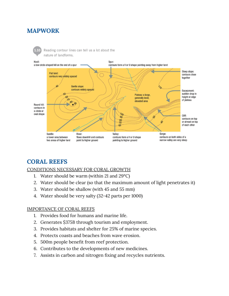
MAPWORK CORAL REEFS CONDITIONS NECESSARY FOR CORAL GROWTH 1. Water should be warm (within 21 and 29°C) 2. Water should be clear (so that the maximum amount of light penetrates it) 3. Water should be shallow (with 45 and 55 mm) 4. Water should be very salty (32-42 parts per 1000) IMPORTANCE OF CORAL REEFS 1. Provides food for humans and marine life. 2. Generates $375B through tourism and employment. 3. Provides habitats and shelter for 25% of marine species. 4. Protects coasts and beaches from wave erosion. 5. 500m people benefit from reef protection. 6. Contributes to the developments of new medicines. 7. Assists in carbon and nitrogen fixing and recycles nutrients. 8. Corals consume particulate matter in water which contributes to water filtration. 9. Creates sand on beaches as it provides sediments from its skeletons. TYPES OF REEFS 1. Fringing Reefs 2. Barrier Reefs 3. Atolls Fringing Reefs ● Found in many Caribbean islands including Barbados, Antigua, Tobago and St. Lucia. ● They are called fringing because they are found directly offshore from continents, providing a 'fringe' around the land. ● They lie close to the shore extending outwards from the mainland. ● They grow near the coastline around islands and continents. ● Separated from the shore by narrow, shallow lagoons. ● Outer edge grows rapidly due to splashing waves Barrier Reefs ● Far less common than fringing reefs. ● The Great Barrier Reef in Australia is the largest and most famous barrier reef in the world. ● The world’s second largest barrier reef is found off the coast of Belize, known as the Belize Barrier Reef, and is over 300 km long. ● They have narrow gaps at several places to allow the water from the enclosed lagoon to return to the open ocean. ● They are parallel to the coastline but are separated by deep wide lagoons. ● They may be several kilometres from shore. Atolls ● Found most often in the Pacific Ocean. ● There are four known atolls in the Caribbean Sea, three found off the coast of Belize. ● An atoll is a roughly circular reef system surrounding a large central lagoon. ● Rings of coral that create protected lagoons are usually located in the middle of the sea. ● Atolls usually form when islands surrounded by fringing reefs sink into the sea or the sea level rises around them. The fringing reefs continue to grow and eventually form circles with lagoons inside. THREATS TO CORAL REEFS Natural ● Large and powerful waves from hurricanes and cyclones can break apart or flatten large corals. ● Increased sea surface temperatures, decreased sea level, and increased salinity from altered rainfall can result in weather patterns. ● Fish, marine worms, barnacles, crabs, snails and sea stars all pray on the inner tissues of coral polyps. Man ● Pollution from land and marine sources ● Fishing Industry ● Aquarium and jewellery trade ● Tourism ● Global warming: coral bleaching RIVERS ● In the upper course of the river, most of its energy is used to overcome friction. ● The river uses its energy to overcome friction, transport its load and erode its course. ● A river begins depositing its load when it starts losing energy. ● A river transports its load by ○ Solution: dissolved material is removed, soluble load is never deposited. ○ Suspension: insoluble, small and light particles float in the river and are deposited in the lower course. ○ Saltation: sediments bounce along the river’s course. ○ Traction: large rocks and boulders are dragged along the river beds. ● Energy increases when there is a decrease in gradient. ● A large load encourages a river to deposit. ● A decrease in volume because of a prolonged drought leads to the deposition of sediments. FEATURES FORMED BY UPPER COURSE 1. V-shaped valley : The river's load vertically erodes the riverbed which forms a steep v shaped valley. It is further eroded when soil and loose rocks are added to the load. It is formed in the upper course of the river. 2. Interlocking spurs: The river meanders around the high hillsides which creates spurs which alternate on each side of the river. It is formed in the upper course. 3. Potholes: The river's currents circularly rotate the pebbles which erodes the riverbed leading to a circular depression. It is formed in the upper course. 4. Rapids: Areas in the river where the water is turbulent due to an increase in gradient or where the river flows over alternating soft and hard rocks. It is formed in the upper course. 5. Waterfalls: It is formed when there is a change in gradient in the course of the river due to the river flowing over an area of hard rock then followed by an area of soft rock, a fault line creating an escarpment, glaciation leaving a tributary hanging above the valley, the uplift of a land forming a steep drop at the end of a plateau, or lava crossing the path of a river. it is formed in the upper or lower course. 6. Gorges: the soft rock erodes, leaving the hard rock hanging and eventually collapsing. The fallen rock crashes into the plunge pool and the process is repeated, forming a steep sided gorge. It is formed in the upper course. FEATURES FORMED BY THE MIDDLE COURSE 1. Meander- A large bend in a river caused by lateral erosion (through hydraulic action and abrasion). The water on the outside of the bend travels fastest and erodes away to form a river cliff . The water on the inside of the bend travels slowest and deposits material to form a slip off slope 2. Oxbow lake - Formation - The outside of the meanders have the quickest water and are eroded by hydraulic action and abrasion. - The outside of the meanders move closer together narrowing the ‘neck’ in between. - Eventually (usually during a flood) the river cuts straight across the neck following the quickest route - After this the river slows down by the old bend and deposits material cutting off a oxbow lake FEATURES FORMED BY THE LOWER COURSE 1. Floodplain- Flat and wide area prone to annual flood cycle. Covered by aluminium/silt, may have small hills on terraces, formed when meanders move due to erosion and deposition across the valley floor 2. Levees- Raised banks along the river. 3. Deltas- Formed if waves and tide cannot carry all the material away. Formation: -A river carrying sediments reaches a sea or lake -It loses energy and deposits material -Sediments may be sorted and the heaviest material is deposited first - Over time more sediments is added -If tide is strong enough the sediments will be washed away and if not it will build up a land mass (delta) at the mouth 4. Braided channel- When a river divides for various distances into 2 and more channels. The channels are separated by islands of sediments called bars. BBraiding occurs when a river carries a large load or when volume of water in the river changes rapidly from season to season ECONOMIC ACTIVITIES: Fishing FISHING IN BELIZE Commercial Fish Species 1. Lobster 2. Conch 3. Finfish 4. Shrimp (aquaculture) 5. Sea cucumbers Importance of the Industry 1. 3% of national GDP in 2015. 2. Belize’s fishing industry supports approximately 15,000 people in Belize, with almost 20% of those being licensed commercial fishers. 3. Lobster is Belize’s primary fisheries commodity that generates over BDZ$30 million 4. Belize’s economy depends on healthy marine resources via a) tourism; since marine attractions are the backbone of our tourism product, and b) commercial fishing in terms of jobs, food security and national export commodities. 5. Fishery products were the third largest foreign exchange earner. 90% of the lobster, conch and shrimp produced in Belize are sold directly to foreign markets, mostly to the United States. ($37.2 million dollars in 2018) Areas with an abundance of fish ● The shallow coastal waters are rich in nutrients washed into the sea by rivers, e.g., Belize River, draining from Belize into the Caribbean Sea ● Mangrove swamps, seagrasses and coral reefs are important breeding and feeding grounds and nurseries for fish, shrimp, conch and lobster. ● Mangroves- fish and shrimp. ● Coral reefs- economically important fish and invertebrate species. Many commercially important fish species, like grouper, snapper, and lobster, depend on coral reefs for food and shelter. ● Seagrasses- fish, conch and lobster for feeding and breeding. Adult fish that hide in the coral reef during the day and venture out at night to feed, take advantage of the rich source of food that exists in the seagrass. Fishing Organisations ● More than half of Belize fishermen are members of an established fishing cooperative in Belize. ● Many fishermen are unlicensed, particularly in southern Belize. ● There are five established and functional fishermen cooperatives: Northern and National Cooperative and The other three smaller cooperatives sell their product to either Northern or National. ● The Belize Fishermen's Cooperative Association (BFCA) is the representative body for the cooperatives, except for Northern. ● They keep watch over the fisheries laws and regulations and influence changes for the protection and preservation of the industry as well as foster and maintain closer cooperation among the cooperatives. Problems Facing Belize’s Fishing Industry ● Overfishing, coastal development, climate change, and coral bleaching are creating habitat damage to key fishery habitats in Belize. ● Piracy and illegal fishing ● Economic constraints Solutions To The Problems ● Managed access to fishing resources ● Monitoring using new technology ● Marine Protected Areas ● Aquaculture DEFINITIONS Weathering: Weathering is the breakdown and decomposition of rocks in the place of their origin. Erosion: Erosion is the breakdown and decomposition of rocks and its removal. Primary Sector: The primary industry is the growing, extracting or collection of raw materials from the Earth or sea, for example: fishing, mining and forestry. Secondary Sector: The secondary industry produces goods from the natural products within the primary sector. Tertiary Sector: The tertiary industry includes companies that provide services such as entertainment, financial, and retailers ROCK CYCLE ● ● ● ● ● The Rock Cycle is a group of changes. Igneous rock can change into sedimentary rock or into metamorphic rock. Sedimentary rock can change into metamorphic rock or into igneous rock. Metamorphic rock can change into igneous or sedimentary rock. This recycling of rocks is called the rock cycle. Igneous Rock ● A rock formed by the cooling and crystallisation of magma (molten rock) at or below the Earth's surface. ● These form when molten rock cools and solidifies. Crystals form on cooling and the rocks are called crystalline rocks. Some igneous rocks, e.g., basalt, have cooled quickly and they contain small crystals. Others, eg. granite has cooled slowly, and they contain large crystals. ● There are two main types of igneous rocks: ○ Plutonic: These have solidified deep in the crust and they are seen on the surface only after being exposed by prolonged erosion. Examples includediabase, diorite, gabbro, granite, pegmatite, and peridotite. ○ Volcanic: These have been poured on to the earth’s surface where they are called lava. Sedimentary ● A rock formed as a result of the weathering process, either by compaction and cementation of rock mineral fragments, or the precipitation of dissolved minerals. ○ There are three different types of sedimentary rocks: ● Clastic- form from clasts, or pieces of other rock. Examples includebreccia, conglomerate, sandstone, siltstone, and shale. ● Organic (biological) - form from hard, biological materials like plants, shells, and bones that are compressed into rock. Examples include- chalk, coal, diatomite, some dolomites, and some limestones. ● Chemical- form from chemical precipitation. A chemical precipitate is a chemical compound—for instance, calcium carbonate, salt,—that forms when the solution it is dissolved in, usually water, evaporates and leaves the compound behind. Limestone is formed when water evaporates leaving behind calcium carbonate crystals that build up over time. Examples include- chert, some dolomites, flint, limestones, and rock salt. Metamorphic ● These rocks form as existing rocks are subjected to intense heat and/or pressure, usually over long periods of time. ● These are formed from rocks whose structure and appearance have been changed by heat or by pressure or by both. ● Any rock can be changed into a metamorphic rock. ● Examples of metamorphic rocks are slate, marble, and graphite. SOIL CREEP ● The movement of soil down the slope under the influence of gravity. ● As the soils move downslope, a series of steps can be formed giving the surface a ripple appearance. ● Can lead to: fences breaking, bases of trees turning downwards, telegraph pole tilting, cracks forming in the road and soil accumulating behind walls. LIMESTONE
