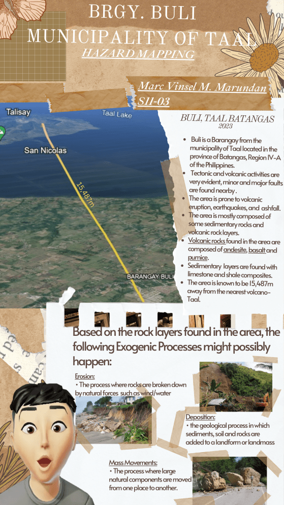
BRGY. BULI MUNICIPALITY OF TAAL HAZARD MAPPING Marc Vinsel M. Marundan S11-03 BULI, TAAL BATANGAS 2023 7m ,48 15 Buli is a Barangay from the municipality of Taal located in the province of Batangas, Region IV-A of the Philippines. Tectonic and volcanic activities are very evident, minor and major faults are found nearby . The area is prone to volcanic eruption, earthquakes, and ashfall. The area is mostly composed of some sedimentary rocks and volcanic rock layers. Volcanic rocks found in the area are composed of andesite, basalt and pumice. Sedimentary layers are found with limestone and shale composites. The area is known to be 15,487m away from the nearest volcanoTaal. Based on the rock layers found in the area, the following Exogenic Processes might possibly happen: Erosion: • The process where rocks are broken down by natural forces such as wind/water Deposition: • the geological process in which sediments, soil and rocks are added to a landform or landmass Mass Movements: • The process where large natural components are moved from one place to another. As seen from the map , The Municipality of Taal is prone to: Ground Shaking Earthquake-Induced Landslide Rain-Induced Landslide Ashfall Volcanic Eruptions The Area is set as Intensity VIII by PHIVLOCS, Indicating that the area is highly destructive ground shaking. However, the area is SAFE from major landslides, as the area is lying low and there are no higher grounds that could potentially erode. Because the area is nearby Taal Volcano which is an active volcano, and if the tectonic plates continue to move, these Endogenic processes will most likely continue: Vulcanism: • The process of eruption of magma from the beneath the Earth’s surface Plutonism: •The formation of intrusive igneous rock by solidification of magma beneath the earth's surface. Earthquakes: • The sudden release of strain energy in the Earth's crust, resulting in waves of shaking that radiate outwards from the earthquake source, mostly because of volcanic and tectonic activities. IF THE EVENTS MENTIONED ABOVE OCCURS, RESIDENTS OF THE AREA MUST: Prepare Emergency Kits Containing: Flashlight Canned Foods Documents Money Clothes Radio Batteries Water Whistle Create Plan For Readiness: Residents must plan an escape or emergency route Familiarize nearby Evacuation Facilities Watch the news Stay alert about the surroundings This Hazard Mapping aims to inform people of the area to be aware of the possible events that might happen in their location. By doing so, the community is educated and equipped with readiness in case these natural disasters occur. Hence, accidents are less likely to occur because everyone is provided with Emergency Readiness and Disaster Response. REFERENCES: Deposition (geology). (2021, February 8). Wikipedia. https://en.wikipedia.org/wiki/Deposition_(geology)#:~:text=Deposition%20is%20the%20geological%20process ownload Emergency kit png graphic clipart design for free. (n.d.). Vecteezy. Retrieved October 27, 2023, from D https://www.vecteezy.com/png/24295782-emergency-kit-png-graphic-clipart-design Graniczny, M. (n.d.). Exogenic Geological Processes As a Landform-Shaping Factor. Geology and Ecosystems, 171–181. https://doi.org/10.1007/0-387-29293-4_14 Hauber, E., Mège, D., Platz, T., & Broz̆ P. (2017, August 23). Endogenic Processes. Springer International Publishing. https://pure.mpg.de/pubman/faces/ViewItemOverviewPage.jsp? itemId=item_3069074_1#:~:text=Endogenic%20processes%20in%20geology%20are Sign in - Google Accounts. (n.d.). Accounts.google.com. Retrieved October 27, 2023, from https://dlsl.instructure.com/groups/179094/discussion_topics/469334?module_item_id=1118547 Wikipedia Contributors. (2019, March 2). Earthquake. Wikipedia; Wikimedia Foundation. https://en.wikipedia.org/wiki/Earthquake


