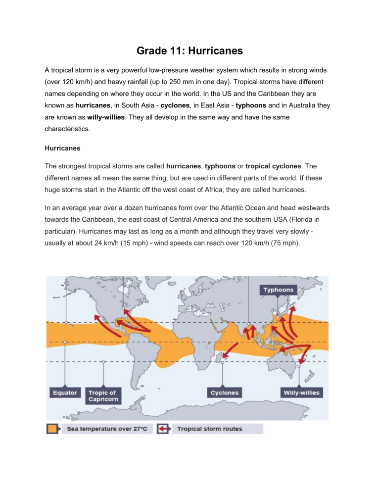
Grade 11: Hurricanes A tropical storm is a very powerful low-pressure weather system which results in strong winds (over 120 km/h) and heavy rainfall (up to 250 mm in one day). Tropical storms have different names depending on where they occur in the world. In the US and the Caribbean they are known as hurricanes, in South Asia - cyclones, in East Asia - typhoons and in Australia they are known as willy-willies. They all develop in the same way and have the same characteristics. Hurricanes The strongest tropical storms are called hurricanes, typhoons or tropical cyclones. The different names all mean the same thing, but are used in different parts of the world. If these huge storms start in the Atlantic off the west coast of Africa, they are called hurricanes. In an average year over a dozen hurricanes form over the Atlantic Ocean and head westwards towards the Caribbean, the east coast of Central America and the southern USA (Florida in particular). Hurricanes may last as long as a month and although they travel very slowly usually at about 24 km/h (15 mph) - wind speeds can reach over 120 km/h (75 mph). Structure, features and the development of tropical storms In appearance, a tropical storm is like a huge whirlpool - a gigantic mass of revolving moist air. Tropical storms are between 482-644 kilometres wide and 6-8 kilometres high. They move forward at speeds of 16-24 km/h, but can travel as fast as 65 km/h. The Coriolis force caused by the rotation of the Earth causes the tropical storm to spin. The central part of the tropical storm is known as the eye. The eye is usually 32-48 km across. It is an area of light wind speeds and no rain. It contains descending air. Large towering cumulonimbus clouds surround the eye. These are caused by warm moist air condensing as it rises. This leads to very heavy rainfall and wind speeds of up to 320 km/h. How hurricanes form Hurricanes need a lot of heat to form and a sea surface temperature of at least 26°C, which is why they usually occur over tropical seas. They also need to be between 5 and 20° north or south of the Equator. It works like this: 1. When this warm and wet air rises, it condenses to form towering clouds, heavy rainfall. It also creates a low pressure zone near the surface of the water. 2. Rising warm air causes the pressure to decrease at higher altitudes. Warm air is under a higher pressure than cold air, so moves towards the ‘space’ occupied by the colder, lower pressure, air. So the low pressure ‘sucks in’ air from the warm surroundings, which then also rises. A continuous upflow of warm and wet air continues to create clouds and rain. 3. Air that surrounds the low pressure zone at the centre flows in a spiral at very high speeds - anti-clockwise in the northern hemisphere - at speeds of around 120 km/h (75 mph). 4. Air is ejected at the top of the storm – which can be 15km high – and falls to the outside of the storm, out and over the top, away from the eye of the storm. As this happens, it reduces the mass of air over the ‘eye of the storm’ - causing the wind speed to increase further. Some ejected air also cools and dries, and sinks through the eye of the storm, adding to the low pressure at the centre. 5. The faster the winds blow, the lower the air pressure in the centre, and so the cycle continues. The hurricane grows stronger and stronger. 6. Seen from above, hurricanes are huge circular bodies of thick cloud around 450 km (300 miles) wide. The cloud brings heavy rain, thunder and lightning. 7. In the centre is the eye of the hurricane, about 45 km across (30 miles) across. Often there will be no clouds in the eye. Seen from below it will seem calmer, with a circle of blue sky above. The eye is formed because this is the only part of the hurricane where cold air is descending. 8. In the northern hemisphere, the prevailing easterly tropical winds tend to steer hurricanes toward land - although their course is unpredictable. As hurricanes move inshore, their power gradually reduces because their energy comes from sucking up moist sea air. Lifecycle of a Hurricane Given the destruction the storm unleashes, it's easy to think of a hurricane as a kind of monster. It may not be a living organism, but it does require sustenance in the form of warm, moist air. And if a tropical disturbance continues to find enough of this "food" and to encounter optimal wind and pressure conditions, it will just keep growing. It can take anywhere from hours to days for a tropical disturbance to develop into a hurricane. But if the cycle of cyclonic activity continues and wind speeds increase, the tropical disturbance advances through three stages: 1.) Tropical depression: wind speeds of less than 38 mph 2.) Tropical storm: wind speeds of 39 to 73 mph 3.) Hurricane: wind speeds greater than 74 mph Between 80 and 100 tropical storms develop each year around the world. Many of them die out before they can grow too strong, but around half of them eventually achieve hurricane status. Hurricanes vary widely in physical size. Some storms are compact, with only a few bands of wind and rain trailing behind them. Other storms are looser -- the bands of wind and rain spread out over hundreds or thousands of miles. Hurricane Floyd, which hit the eastern United States in September 1999, was felt from the Caribbean islands to New England. Once a hurricane has formed and intensified, the only remaining path for the atmospheric juggernaut is dissipation. Eventually, the storm will encounter conditions that deny it the warm, moist air it requires. When a hurricane moves onto cooler waters at a higher latitude, gradient pressure decreases, winds slow, and the entire storm is tamed, from a tropical cyclone to a weaker extratropical cyclone that peters out in days. That important supply of warm, moist air also vanishes when the hurricane makes landfall. Condensation and the release of latent heat diminishes, and the friction of an uneven landscape decreases wind speeds. This causes winds to move more directly into the eye of the storm, eliminating the large pressure difference that fuels the storm's awesome power. Hurricane Categories Hurricanes can unleash incredible damage when they hit. With enough advance warning though, cities and coastal areas can give residents the time they need to fortify the area and even evacuate. To better classify each hurricane and prepare those affected for the intensity of the storm, meteorologists rely on rating systems. Australian meteorologists use a slightly different scale to classify hurricanes. While the Australian scale of cyclone intensity also ranks storms by wind speed and damage on a scale of 1 to 5, it covers both hurricanes and tropical storms. Hurricane Damages Over the course of millennia, hurricanes have cemented their reputation as destroyers. Many people even frame them as the embodiment of nature's power or acts of divine wrath. The word "hurricane" itself actually derives from "Hurakan," a destructive Mayan god. No matter how you choose to sum up or personify these powerful acts of nature, the damage they inflict stems from several different aspects of the storm. Hurricanes deliver massive downpours of rain. A particularly large storm can dump dozens of inches of rain in just a day or two, much of it inland. That amount of rain can create flooding, potentially devastating large areas in the path of the hurricane's fierce center. In addition, high sustained winds within the storm can cause widespread structural damage to both man-made and natural structures. These winds can roll over vehicles, collapse walls and blow over trees. The prevailing winds of a hurricane push a wall of water, called a storm surge, in front of it. If the storm surge happens to coincide with high tide, it causes beach erosion and significant inland flooding. The hurricane itself is often just the beginning. The storm's winds often spawn tornadoes, which are smaller, more intense cyclonic storms that cause additional damage. You can read more about them in How Tornadoes Work. The extent of hurricane damage doesn't just depend on the strength of the storm, but also the way it makes contact with the land. In many cases, the storm merely grazes the coastline, sparing the shores its full power. Hurricane damage also greatly depends on whether the left or right side of a hurricane strikes a given area. The right side of a hurricane packs more punch because the wind speed and the hurricane's speed of motion complement one another there. On the left side, the hurricane's speed of motion subtracts from the wind speed. This combination of winds, rain and flooding can level a coastal town and cause significant damage to cities far from the coast. In 1996, Hurricane Fran swept 150 miles (241 km) inland to hit Raleigh, N.C. Tens of thousands of homes were damaged or destroyed, millions of trees fell, power was out for weeks in some areas and the total damage was measured in the billions of dollars. The impacts of climate change on tropical storms Climate change could lead to more locations being affected by tropical storms. Warmer seas could cause the source areas (the areas where the storms would form) to extend further north and south of the equator. It's unclear whether climate change will increase or decrease the number of hurricanes, but climate models predict that their intensity may increase. The following factors may play a part in increasing their impact: ● warmer ocean surface temperatures and higher sea levels ● wind speeds potentially increasing 2-11 percent ● rainfall rates during these storms are projected to increase by about 20 percent In addition, sea level rise is likely to make tropical storms more damaging with increases in coastal flooding and subsequent storm damage along coasts. Low-lying coastal communities where the population density is high and the income level low are most at risk. More people living in coastal communities in the future will mean that more people will be affected. Tropical storm case study Hurricane Sandy Hurricane Sandy, a tropical storm occurring in October 2012, started life off the coast of West Africa. It travelled north-west across the Atlantic Ocean through countries such as Cuba, Haiti and The Bahamas in the Caribbean before hitting the east coast of the USA. It led to a wide range of impacts. Impacts Economic ● Hurricane Sandy was the second most costly hurricane on record, causing $71 billion in damages. In New York City, economic losses are estimated at exceeding $18 billion. ● Buildings, cars, people's possessions and business stock were lost. ● More than 18,000 flights were cancelled leading to disruptions in business, tourism and trade. ● Crops were lost resulting in loss of earnings for farmers. Social ● At least 286 people were killed either directly or indirectly by Hurricane Sandy. There were 147 direct deaths: 72 in the USA and the rest mainly in the Caribbean, including 54 in Haiti and 11 in Cuba. ● Power failure at New York University Langone Medical Centre led to the evacuation of all 215 patients to other hospitals. ● People were highly stressed and anxious. In the longer term, many people could be affected psychologically by the loss of family and friends. ● More than 8.5 million homes and businesses were left without power. ● In Washington DC and other cities, many supermarkets ran out of essentials such as bottled water and batteries as people prepared for the worst. ● The New York City marathon was cancelled resulting in a loss of income for many businesses. Environmental impacts ● 346,000 houses were damaged or destroyed in New Jersey and 305,000 damaged or destroyed in New York. ● Makeshift shanty towns in Haiti were washed away. ● Fallen trees and flooded vegetation affected animals' habitats. ● In areas such as New York and New Jersey, untreated sewage was washed into public drinking water, threatening human health. ● More than 70 percent of crops, including bananas and maize, were destroyed in the south of Haiti. ● Roads, train lines and other transport infrastructure became unusable due to flooding, resulting in disruptions to travel and trade. ● Approximately 10 metres of beach was lost in some parts of New Jersey, (making it narrower) exposing the coast to further erosion and impacting wildlife. Responses The responses to Hurricane Sandy were very varied. In poorer countries like Haiti there was insufficient prediction, planning or protection and at the time the country was still trying to recover from an earthquake in 2010. This tropical storm set the country back further in terms of its development. In contrast to this, the USA, a richer country, invested more in tropical storm prediction, planning and protection. By using satellite images and other weather instruments The National Hurricane Centre in Miami predicted and monitored the path of Hurricane Sandy. The Centre was able to issue warnings to the local authorities and general public and this helped reduce the impact of Hurricane Sandy. Steps taken to minimise damage ● the President of the USA, Barack Obama, and the authorities appealed to people to stay calm and out of harm's way ● the police evacuated hundreds of thousands of people from low-lying coastal areas most vulnerable to Hurricane Sandy ● schools and public transport services closed down and many flights were cancelled ● people temporarily relocated to evacuation centres such as schools and community centres In the long term, governments will need to develop strategic plans to prepare for tropical storms. Investments made in flood prevention and coastal protection schemes such as sea walls will be essential. Careful consideration needs to be given to the use of land particularly in low-lying areas. Local people and emergency service teams will need training in how to respond to tropical storm events, ensuring a coordinated and planned response. This should reduce the impact of tropical storms on people and the environment.
