main form-eqp7200-22-surface-facility-location-and-environmental-impact-assessment-michigan
advertisement
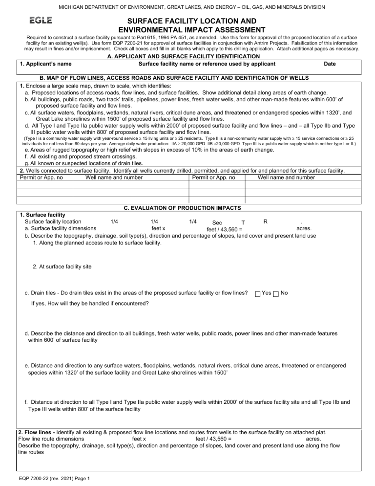
MICHIGAN DEPARTMENT OF ENVIRONMENT, GREAT LAKES, AND ENERGY – OIL, GAS, AND MINERALS DIVISION SURFACE FACILITY LOCATION AND ENVIRONMENTAL IMPACT ASSESSMENT Required to construct a surface facility pursuant to Part 615, 1994 PA 451, as amended. Use this form for approval of the proposed location of a surface facility for an existing well(s). Use form EQP 7200-21 for approval of surface facilities in conjunction with Antrim Projects. Falsification of this information may result in fines and/or imprisonment. Check all boxes and fill in all blanks which apply to this drilling application. Attach additional pages as necessary. 1. Applicant’s name A. APPLICANT AND SURFACE FACILITY IDENTIFICATION Surface facility name or reference used by applicant Date B. MAP OF FLOW LINES, ACCESS ROADS AND SURFACE FACILITY AND IDENTIFICATION OF WELLS 1. Enclose a large scale map, drawn to scale, which identifies: a. Proposed locations of access roads, flow lines, and surface facilities. Show additional detail along areas of earth change. b. All buildings, public roads, ‘two track’ trails, pipelines, power lines, fresh water wells, and other man-made features within 600’ of proposed surface facility and flow lines. c. All surface waters, floodplains, wetlands, natural rivers, critical dune areas, and threatened or endangered species within 1320’, and Great Lake shorelines within 1500’ of proposed surface facility and flow lines. d. All Type I and Type IIa public water supply wells within 2000’ of proposed surface facility and flow lines – and – all Type IIb and Type III public water wells within 800’ of proposed surface facility and flow lines. (Type I is a community water supply with year-round service ≥ 15 living units or ≥ 25 residents. Type II is a non-community water supply with ≥ 15 service connections or ≥ 25 individuals for not less than 60 days per year. Average daily water production: IIA ≥ 20,000 GPD IIB <20,000 GPD Type III is a public water supply which is neither type I or II.) e. Areas of rugged topography or high relief with slopes in excess of 10% in the areas of earth change. f. All existing and proposed stream crossings. g. All known or suspected locations of drain tiles. 2. Wells connected to surface facility. Identify all wells currently drilled, permitted, and applied for and planned for this surface facility. Permit or App. no Well name and number Permit or App. no Well name and number C. EVALUATION OF PRODUCTION IMPACTS 1. Surface facility Surface facility location 1/4 1/4 1/4 R . Sec T a. Surface facility dimensions feet x acres. feet / 43,560 = b. Describe the topography, drainage, soil type(s), direction and percentage of slopes, land cover and present land use 1. Along the planned access route to surface facility. 2. At surface facility site c. Drain tiles - Do drain tiles exist in the areas of the proposed surface facility or flow lines? Yes No If yes, How will they be handled if encountered? d. Describe the distance and direction to all buildings, fresh water wells, public roads, power lines and other man-made features within 600’ of surface facility e. Distance and direction to any surface waters, floodplains, wetlands, natural rivers, critical dune areas, threatened or endangered species within 1320’ of the surface facility and Great Lake shorelines within 1500’ f. Distance at direction to all Type I and Type IIa public water supply wells within 2000’ of the surface facility site and all Type IIb and Type III wells within 800’ of the surface facility 2. Flow lines - Identify all existing & proposed flow line locations and routes from wells to the surface facility on attached plat. Flow line route dimensions feet x feet / 43,560 = acres. Describe the topography, drainage, soil type(s), direction and percentage of slopes, land cover and present land use along the flow line routes EQP 7200-22 (rev. 2021) Page 1 3. Residentially zoned areas Yes No Is the location of the proposed surface facility in an area zoned residential prior to January 8, 1993?. 4. Hydrogen Sulfide Yes No Will the surface facility receive hydrocarbons with a hydrogen sulfide (H2S) concentration greater than 300 ppm? If so, the distance requirements of R324.1106 and R324.1126 apply. If the facilities are associated with production from Class II and Class III/IV (H2S) wells and an exception to the 600’ setback is sought, please include a completed EQP 7241 with this application. If the production facilities are located in an area zoned residential prior to January 8, 1993, then the applicant must provide written notification from the zoning authority that it does not object to their location OR the applicant must petition the supervisor of wells for a variance from the requirement pursuant to R324.506(b) 5. Method of brine disposal Dedicated flow line to Transported by tanker. Other disposal well, permit number 6. Method of transporting hydrocarbons past the point of sale Oil sold through transmission line Gas sold through transmission line Oil transported by tanker for sale Gas flared on site (production restrictions may apply) Other __________________________________________________________________________________________________ D. MITIGATION OF IMPACTS FROM PRODUCTION Detail measures to be taken to protect environmental and/or land use values. Consider berming, screening, access road location, odor and noise control. Identify additional permits to be sought E. ADDITIONAL PERMITS F. SOIL EROSION AND SEDIMENTATION PLAN Enclose Soil Erosion and Sedimentation Plan (Form 7200-18) which addresses each surface facility and flow line route identified in this application. (REFER TO REQUIREMENTS UNDER PART 91, 1994 PA 451.) G. ALTERNATE WELL AND SURFACE FACILITY LOCATIONS Were alternate surface locations considered for this surface facility? No, alternate sites did not seem necessary or more desirable Yes, the following locations were considered Why were they rejected in favor of the proposed location? H. SECONDARY CONTAINMENT PLANS Attach secondary containment construction plans for surface facility pursuant to R324.1002(2) I. CERTIFICATION “I state that I am authorized by said applicant to prepare this document. It was prepared under my supervision and direction. The facts stated herein are true, accurate and complete to the best of my knowledge.” Name and title (printed or typed) Authorized Signature OIL, GAS, AND MINERALS DIVISION USE ONLY This surface facility is approved for construction as described OGMD Signature Date Date OGMD Surface facility name or reference ___________________________________________________________________________ Submit to the OGMD Area Geologist and appropriate District Office email. Cadillac: EGLE-OGMD-Records-Cadillac@michigan.gov Kalamazoo: EGLE-OGMD-Records-Kalamazoo@michigan.gov Saginaw Bay: EGLE-OGMD-Records-SaginawBay@michigan.gov Gaylord: EGLE-OGMD-Records-Gaylord@michigan.gov Lansing: EGLE-OGMD-Records-Lansing@michigan.gov SE Michigan: EGLE-OGMD-Records-SEMichigan@michigan.gov If you need this information in an alternate format, contact EGLE-Accessibility@Michigan.gov or call 800-662-9278. EGLE does not discriminate on the basis of race, sex, religion, age, national origin, color, marital status, disability, political beliefs, height, weight, genetic information, or sexual orientation in the administration of any of its programs or activities, and prohibits intimidation and retaliation, as required by applicable laws and regulations. Questions or concerns should be directed to the Nondiscrimination Compliance Coordinator at EGLENondiscriminationCC@Michigan.gov or 517-249-0906. This form and its contents are subject to the Freedom of Information Act and may be released to the public. EQP 7200-22 (rev. 2021) page 2
